


![Request for Information – Potential [Placeholder for Prize]](https://assets.science.nasa.gov/dynamicimage/assets/science/psd/solar/2023/09/s/solarsystem_0.jpg?w=1024)


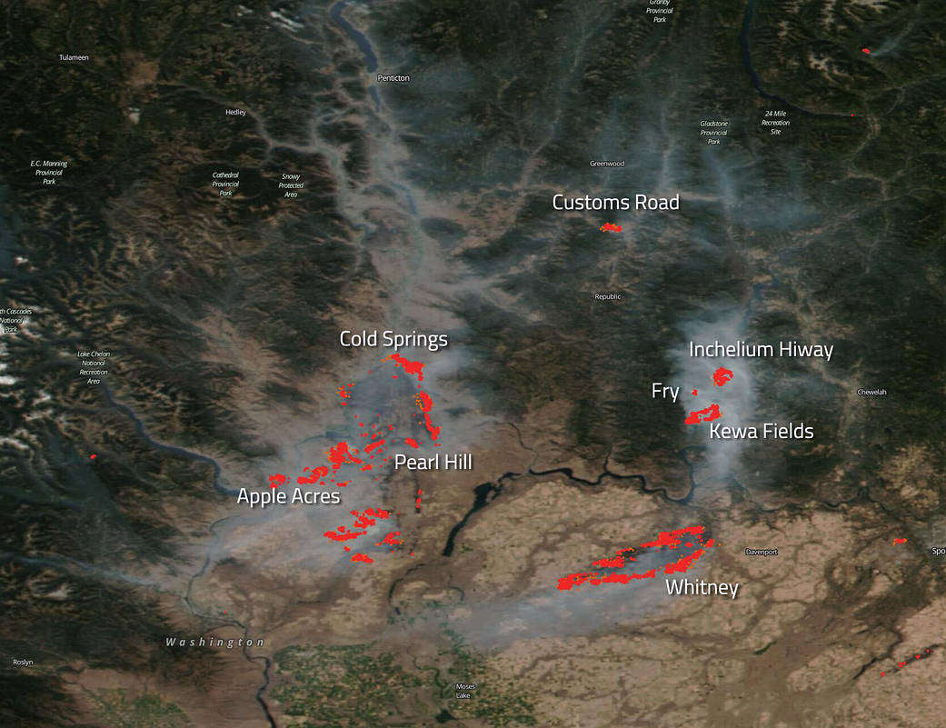
NOAA/NASA’s Suomi NPP satellite focused on the fires in Washington state and took aim at the “ring of fire” in northern Washington in this image taken on Sep. 8, 2020. The startling true-color image of fires in the northern part of Washington state reveals the area around the Lake Roosevelt National Recreation Area is currently encircled by at least eight fire incidents. The fires that create the “ring of fire” include the following: Customs Road, Inchelium Complex (includes Fry and Kewa Fields), Whitney, Apple Acres, Pearl Hill, and Cold Springs. All of these fires began on Sep. 7, 2020, but the cause is currently unknown and under investigation. The light gray colored smoke from these fires has combined to create a giant “smoke ring” as seen from space.
The Customs Road fire at the top of the ring is located just south of the Canadian border and that fire has consumed 600 acres with 0% containment as of Sep. 9, 2020. This fire is exhibiting extreme fire behavior and evacuations are being carried out. Extreme fire behavior is defined as a fire that exhibits at least one of the following behaviors: high rate of spread, prolific crowning (movement of fire through the tops of trees), spotting (fire producing embers that land and create new fires), presence of fire whirls (a whirlwind induced by a fire and often composed of flame or ash), a strong convection column (rising column of gases, smoke, fly ash, particulates, and other debris produced by a fire). Evacuations and evacuation notices are commencing.
The Inchelium Complex (consisting now of the Inchelium, Fry, and Kewa Fields fires) is 8,000 acres in size, with 20% containment. This fire is exhibiting active fire behavior meaning it is actively spreading. Evacuations are also taking place around this complex.
The Whitney fire has consumed 130,000 acres since it began and is 0% contained. It is exhibiting extreme fire behavior and there have been evacuations made due to the fire.
The Apple Acres fire is 6,300 acres and is 36% contained. It is exhibiting moderate fire behavior which is defined as: “A fire with a fast continuous rate of spread that will consume stem material up to 2 inches in diameter.”
The Pearl Hill fire is at 174,000 acres and is 10% contained. This fire was split off from the Cold Springs fire and is also exhibiting moderate fire behavior. Evacuations and evacuation notices have been issued due to this fire.
The Cold Springs fire is 163,000 acres with 0% containment and is exhibiting extreme fire behavior with evacuations and evacuation notices in place.
All of these fires discussed above are currently under full suppression tactics by firefighters.
Weather concerns include continuous, strong winds which have expanded large fire perimeters and threatening several communities. Overnight humidities recovered well in northeast Washington while on the east side of the Cascades overnight humidities were single digits in some areas.
NASA’s satellite instruments are often the first to detect wildfires burning in remote regions, and the locations of new fires are sent directly to land managers worldwide within hours of the satellite overpass. Together, NASA instruments detect actively burning fires, track the transport of smoke from fires, provide information for fire management, and map the extent of changes to ecosystems, based on the extent and severity of burn scars. NASA has a fleet of Earth-observing instruments, many of which contribute to our understanding of fire in the Earth system. Satellites in orbit around the poles provide observations of the entire planet several times per day, whereas satellites in a geostationary orbit provide coarse-resolution imagery of fires, smoke and clouds every five to 15 minutes. For more information visit: https://www.nasa.gov/mission_pages/fires/main/missions/index.html
NASA’s Earth Observing System Data and Information System (EOSDIS) Worldview application provides the capability to interactively browse over 700 global, full-resolution satellite imagery layers and then download the underlying data. Many of the available imagery layers are updated within three hours of observation, essentially showing the entire Earth as it looks “right now.” Actively burning fires, detected by thermal bands, are shown as red points. Image Courtesy: NASA Worldview, Earth Observing System Data and Information System (EOSDIS). Caption: Lynn Jenner with information from the Northwest Interagency Coordination Center.