


From Earth orbit to the Moon and Mars, explore the world of human spaceflight with NASA each week on the official podcast of the Johnson Space Center in Houston, Texas. Listen to in-depth conversations with the astronauts, scientists and engineers who make it possible.
On Episode 260, Dr. Robert Green and Dr. David Thompson discuss how the Earth Surface Mineral Dust Source Investigation on the International Space Station is helping solve the mysteries of dust on Earth. This episode was recorded on August 9, 2022.
![]()
Transcript
Gary Jordan (Host): Houston, we have a podcast! Welcome to the official podcast of the NASA Johnson Space Center, Episode 260, “Mysteries of Dust.” I’m Gary Jordan and I’ll be your host today. On this podcast we bring in the experts, scientist, engineers, and astronauts, all to let you know what’s going on in the world of human spaceflight. Dust is really everywhere on Earth. In our own lives, we may think of hazy skies that eventually just go away, but these tiny particles can have a big impact on the planet’s climate. One experiment that launched to the International Space Station on SpaceX’s 25th cargo resupply mission is taking a whole new look at Earthly dust. The Earth Surface Mineral Dust Source Investigation, or EMIT, is making history by studying the composition of surface mineral dusts around the entire world. Joining us from NASA’s Jet Propulsion Laboratory to talk about EMIT, we have Dr. Robert Green and Dr. David Thompson. Robert Green is the principal investigator of EMIT. For more than 25 years his research has used advanced imaging spectrometer instrumentation to test hypotheses and pursue scientific investigations and applications research on Earth and throughout the solar system. David Thompson is a senior research scientist at the Jet Propulsion Laboratory and the California Institute of Technology. His research advances the algorithms and practice of imaging spectroscopy for characterizing Earth and other planetary bodies. He’s an instrument scientist for NASA’s EMIT and has a long history on the programming end of spectroscopy. David’s technologies have been fielded in four continents, three oceans, three Earth-orbiting spacecraft, and twice to the surface of Mars. Rob and David will clear the dust off the mysteries of EMIT and reveal how we’ll soon be able to better understand more about our home planet. Here we go; enjoy.
[Music]
Host: Rob and David, thank you so much for coming on Houston We Have a Podcast.
Robert Green: Hello, this is Rob Green. I’m very pleased to join you today.
David Thompson: And this is David Thompson. It’s a pleasure to be here.
Host: Great. This is such an interesting experiment. There’s a lot of stuff going on in the International Space Station, but this one is looking at the Earth in a very unique way. And I just wanted to start, I think before we really get into the experiment, with a little bit about yourselves, because this is a very interesting area of study, it seems very specific, and I wonder just sort of what led you to it. Rob, if we can start with you, just sort of what, how your career sort of led you to studying, of all things, dust on the surface of Earth.
Robert Green: Sure. Glad to chat about that. It goes back actually to my master’s degree at Stanford University, where I got very interested in spectroscopy of the Earth system. It was just becoming a field that was being applied with a new set of instruments called imaging spectrometers. And that actually drew me to JPL, to work with the very first imaging spectrometer and a follow-on spectrometer, and it turns out a series of spectrometers that we’ve used to answer questions on Earth and across the solar system, but specifically on EMIT it was realizing we had this experimental technology of imaging spectroscopy and talking with my colleagues at the USGS (United States Geological Survey) realizing there is this gap in knowledge about the mineral source regions that, when encountering high winds, those minerals are emitted or launched into the atmosphere where they interact throughout the Earth system, and realizing there was a gap in knowledge of what the, the source region mineralogy were and that if we could get at that we could really address a suite of science questions and specifically the ones that EMIT tackles, which is related to climate, a direct radiator forcing heating, cooling of our planet, locally, globally, and regionally.
Host: So I mean, what was originally that, that drew you to, to EMIT specifically and, and to the, to this area of study? You know, there’s a lot of different things that are affecting the climate. You know, you could talk about CO2 (carbon dioxide) emissions, you can talk about a lot of different things but, but this one seems very specific. Was it, was it sort of a mix of maybe the mineralogy, geology and then Earth science that sort of drew you to this world that you found most fascinating, or maybe a gap in the knowledge that you just wanted to explore?
Robert Green: Yes. I’m an Earth scientist, experimentalist by nature, and have been involved with a range of, of studies across the Earth system. So it was realization that here was an opportunity to test a hypothesis to advance science, with the, the technology and the experimental method that I’ve specialized in which is imaging spectroscopy, and they came together perfectly. There’s a huge gap in knowledge: currently the Earth’s mineral dust source regions are characterized by 5,000 — only 5,000 — mineral analyses for the entire planet Earth. And we had an opportunity with NASA technology from the International Space Station to update that with a billion direct observations of the surface mineralogy via imaging spectroscopy. So once that narrative and, and opportunity to test hypotheses and move science forward became clear, that’s when we pulled the science team together and we wrote this compelling proposal, which was reviewed in a competitive sense and selected to be implemented.
Host: Excellent, excellent. I want to dive into that as well, too, a little later in this podcast, just how, how, how EMIT came to be. But David, we’ll go to you for a second, too, because I, I want to understand a little bit about what led you to, to this world, and then ultimately, how your world’s collided with, with you and Rob to, to eventually start studying this?
David Thompson: Sure. Well, I came to this world by a rather circuitous route, actually. I started off in the field of machine learning and artificial intelligence doing data science related things throughout grad school. In Carnegie Mellon I studied robotics, mostly in the context of planetary exploration. And in that domain, you really can’t escape spectrometers, they’re everywhere. These are the instruments that are really fundamental for understanding the composition of planetary bodies. If you’re rolling over the surface of Mars with a rover or looking at distant exoplanets, everything is a spectrometer, practically. And so, I, I became acquainted with the, this technique pretty early, but it was always from a data science perspective, always from trying to interpret the data, look at patterns in the data and understand from a mathematical perspective how we can make these measurements accurately. And then I, when I came to JPL I, everybody started talking to me about imaging spectroscopy, for which JPL at that time and, and currently, is still very famous for. JPL originated the technique early in the 80s and since then it has really refined and perfected it. And so, I, I was introduced to these fantastic new data sets where, now I just wasn’t looking at a single spectrum, I had a whole image where every pixel in the image was a full spectrum of data, and these are just incredibly rich, powerful objects, almost magical in their power for understanding the world around us. And, and so I became enamored with them, and came to meet Rob who at that point was spearheading JPL imaging spectroscopy development, and came to the EMIT mission through that. So since then I’ve been working on advancing the measurement technique, bringing to bear all of these tools of statistics and computer science on these really rich, fantastic data sets, and have added to that the physics understanding, I think, that is, that is so critical for interpreting these data.
Host: Very interesting. Now imaging spectrometers, this is something that, that I want to focus on for just a little bit. You, you talked about these opening up a whole new world. And I want to understand, Robert, maybe we’ll go to you for a little bit, is just, you know, there’s, it’s, it’s a world of looking at things, all of these different aspects of science, just in, in a different way. So, when, when it came to, when it came to this mineral dust and, and that sort of thing, and, and really just some of the, some of your other work as well — we can even dive into a little bit of your other work — when you, when you started applying this imaging spectrometer, spectrometers to and studying some of these things, some of these things in your, in your career, what was, I think maybe the most fascinating or, or the most surprising in terms of what they revealed and the stories that they told, that was maybe promised in some of the early uses of this technology?
Robert Green: Sure, pleased to; it, it is one of my passions. I would say spectroscopy is one of the most important exploratory methods discovered by humanity. And again, it goes back to [Joseph von] Fraunhofer in Germany who used a spectrometer to answer some questions. But what, what we do when we measure a spectrum of reflected light, which is the area I’ll be speaking about, is we measure the light that’s interacted with matter, in some sense. In this case of EMIT, we look at light that’s originated from the Sun, it’s passed through the Earth’s atmosphere, it’s interacted with minerals and other materials on the surface, and up to our instrument. And, and we measure that light, and we notice that the light we measure is different than the light that left the Sun. And it’s different because the fingerprints of the molecules and particles it’s interacted with have, have taken bits and pieces — in some cases added bits and pieces — to the spectrum we got to measure. And, and then we can look at the spectrum we measured and invert or derive those materials: we have to derive the atmosphere and compensate for it; if there’s vegetation we have to assess it and remove it. And then we get to the mineral signatures and there we see the signatures to the mineral molecules on the surface. So it’s an incredibly powerful technique. And that’s the core, is we’re looking at the fingerprints of matter that has interacted with that light signal that we got to measure. And just briefly, I’ve seen it shift paradigms again and again. I was involved with the Moon Mineralogy Mapper, which was launched in 2008, and a year and a day after launch, we had the cover of the journal Science with the discovery of hydroxylene water compounds on the illuminated surface of the Moon, which was thought not to be possible; the Moon gets up to 400 Kelvin. The, just an example that we captured the spectrum that included the signature region of hydroxylene water, and we saw it in places no one expected; that was extraordinary. Another quick one on our planet is methane. We deal with comparably core spectral resolution imaging spectrometers, five and ten nanometers. The conventional wisdom, you would never be able to look at gases in the Earth atmosphere in any useful way with these measurements. But we did. We overflew gas fields, petroleum extraction fields in California and, and, and methane seeps in the Santa Barbara Channel. And we saw, we were very sensitive, in fact, to point source emissions, where the concentrations are high. And now JPL is building an instrument called the Carbon Plume Mapper for space to map methane point sources and help us mitigate that. So those are two examples, water on the Moon, methane point sources, which the conventional wisdom was this wasn’t going to be possible with the kind of spectroscopy we were using, and yet we’ve shown that in fact it is possible and it’s incredibly powerful. So those are just a couple examples.
Host: Very powerful examples, too. What you’re talking about is using this technology to look at something just in a, in a new way. And I think the idea is you just take that technology, and you look at it with the expectation that you might be surprised that you might find something there that, that you didn’t really expect, or maybe even know to look for, or maybe, and Rob, you can maybe help clarify this, is did you maybe have an idea of what you were looking for while looking for it or was it really just, let’s see what we find?
Robert Green: We did have an idea in both cases. With the Moon, we thought we might see evidence of hydroxyl up near the permanently shadowed regions, just a fleeting example. There are permanently shadowed craters on the Moon where the hypothesis that Sun never gets into them, if you were going to have water or ice that’s where it would be. So we, we knew we should be looking; but we found is the hydroxyl signature extends to tremendously low latitudes, almost to the equator, perhaps, of the Moon, and that was completely unexpected. And in the case of methane, we knew methane was a molecule interacting in our spectrum and its signature would be there, but the conventional wisdom is you needed much finer spectral resolution — and you do, to get to lower precisions — but we discovered that the point source, the place where the methane is coming out of the gas pipeline leak or, or whatever, that in a localized region the concentration are high enough for us to have really wonderful sensitivity to map these point sources. And it’s those, quote, “super emitters” that if we can get a handle on now and mitigate, we can actually turn some tenth of a C off the current trend in global temperature rise. Now, we’ve diverged far from EMIT, but that’s a quick answer.
Host: But the idea, I, exactly, we’re, we’re sort of giving an understanding of what the technology is inside EMIT and why it’s important to, and we’ll, we’ll investigate that a little further, but, but that’s, what’s being revealed to me doing this deeper dive into spectroscopy. And David, I think when, when you’ve talked about your early fascination with it, that seems, it seems to me that that’s really it is, is looking at things a little bit differently and, and finding these, and maybe coming up with a hypothesis ahead of time like Rob was mentioning, but maybe finding some things. And I wonder, I think maybe, get, I’m trying to feel that sense of excitement that maybe you feel, and, and I think what I can maybe relate to moreso is, if you’re, if you’re parsing through these data and you see, and you’re, you’re, you’re seeing this, this new way of looking at something through spectroscopy, and you have that moment where something is revealed to you, the thing that you were looking for, or maybe the thing that you were not looking for, can you talk about, maybe you have some, some story of parsing through data on one of your earlier experiments where you found something and that, and that emotion that, that, that came to, to surface while you were looking at just, just pieces of data, but just through, through this, this new lens?
David Thompson: Oh yeah. No, absolutely. I think, well I, I should say first that I think both of Rob’s examples, methane and water on the Moon, sort of exemplify the nature of, of imaging spectroscopy and that these really rich data sets where even a single image can be a sub, the subject of its own investigation, and you can continue studying that image for years and discovering new things about it that you didn’t know before, just because of the richness of that data. We’re measuring a wavelength regime from the ultraviolet out through the shortwave infrared. So we’re capturing most of the Sun’s energy that is incident on the surface, that’s reflected back to the sensor and available to it. And in that wavelength range we’re sensitive to hundreds, thousands of different physical and chemical processes on the Earth’s surface and in the atmosphere, all of which leave these distinctive fingerprints and modulations on the spectra that we receive. So even in a single spectrum, you know, a few hundred numbers worth of illumination values at the sensor, you know, that’s the, the potential for a year of exploration to try and model and understand all the processes that gave rise to that single measurement. Now that’s just one pixel of a single image that we acquire. So, now it gives you a feel for just how rich these, these data sets are, and how many different processes we are, we’re sensitive to. And I think for me this was driven home in — I’ll, I’ll talk actually about the methane case that Rob was describing — so for a while we had studied methane exclusively in images after the fact, but it was thought that by actually loading this, this, loading this, this software onto the aircraft itself as we were flying over these methane fields, we could be a little bit more dynamic in our, in our mission planning. So we could actually fly over a field, identify the specific plumes and, you know, the, the facilities that were leaking, and then quickly text a ground team that could go out with a separate instrument to corroborate that measurement and give us for the first time a real ground truth validation of these remote measurements that we were making. And so this involved actually me flying around in an aircraft debugging software on the sensor, in real-time, while we were trying to get the thing to run; this happened for a few weeks while we did test flights. And then finally game day came. We flew out to Four Corners, New Mexico, where we’d identified a large-scale methane hotspot from space, but the sensor could only tell us that it was in the approximate vicinity of Four Corners, it couldn’t actually identify whether it was coming from an anthropogenic source or a geologic seep or anything like that. So through this campaign we overflew a couple of coal mines, turned on the sensor and immediately saw these beautiful methane plumes streaming across the scene as we were flying overhead. And we didn’t even know if it would work or not, you know, until we tried it, but there you go, and immediately we were able to text the ground team to go out with a thermal camera and, and see the plumes from the ground and confirm that, yes indeed, these detections that we were making were, were very real. And so this is just one of many examples where, you know, imaging spectroscopy surprised us with, with its power.
Host: Amazing, amazing. What a moment. I want to, I want to take that and, and what we’re learning about spectroscopy and its importance, and sort of fold that into this new, this new topic, which, which would be more so on the dust. Now, we’re going to talk about EMIT and what we’re looking at is dust and from what, from understanding, just talking to you gentlemen a little bit ahead of this, we’re, it’s, it’s a very particular thing that we’re looking at when it comes to dust. Rob, if you can just sort of give us an overview of what it is exactly this area of study, studying dust on the planet? There’s dust everywhere, it’s blowing all over the place. So if you can give us an understanding of, of why this is being studied, what its impact is on the planet, and then we’ll fold into exactly what it is EMIT is looking at?
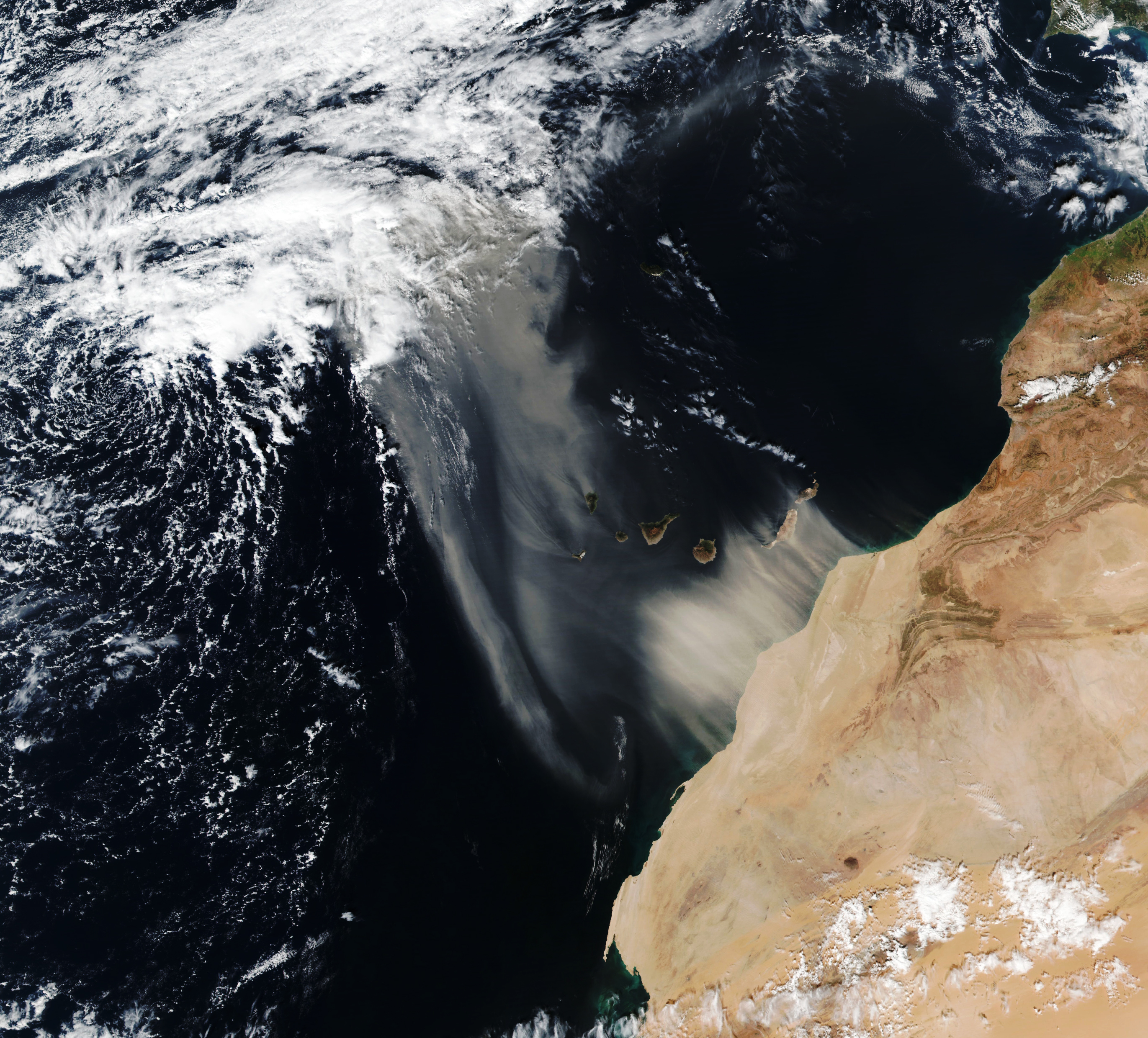
Robert Green: OK, terrific. So in the arid land regions of our planet under conditions of high winds, surface mineral dust — the little particles left over from rocks being ground up to various alluvial processes, typically — are, are launched into the atmosphere, and then when they enter the atmosphere they begin to interact immediately. They absorb or scatter light, which heats or cools the atmosphere in that region; they play a role in cloud formation, the condensation nuclei; they actually change the chemistry of the atmosphere, which enables other atmospheric processes. So right off, surface connected to atmosphere. Then, as they’re deposited: if they’re deposited in, in oceans they become nutrients and can cause algal blooms affecting aquatic ecosystems; if they [are] deposited in terrestrial ecosystems — in rainforest, for example, at South America — they can be key nutrients there as well, playing a role in those ecosystems; if those dust particles land on snow, they accelerate melting and that has huge impacts for local albedos, brightness or darknesses of the surface, but maybe as importantly water resources — how fast that snowpack melts in California, where I live, has a big impact on how much water come from Sierra Nevadas that that society can, can use or not use. The same is true for Colorado and in many other parts of the world that rely on that. And then if they land where we live, they can be a visibility hazard; there can be all sorts of consequences to visibility. And in fact their particulate nature and chemical composition á la mineralogy can have a toxicity impact. For example, there are dust regions in California where the dust particles are made of naturally-occurring asbestos, which you could imagine would be a bad thing to, to breathe. So those are just, so the mineral dust cycle is throughout the Earth system, it connects the surface geology to the atmosphere, to the solar energy absorb, to the aquatic ecosystem, to the terrestrial ecosystem, to the snow hydrology, and to the area that, that humanity lives. So it’s, it’s just the most extraordinary cycle, and then we discovered there was a gap in knowledge, people don’t understand what the composition of the source regions are.
Host: So what does that mean then? So, so we have this, you, you’re talking about a, a greater understanding of what’s happening and how dust is affecting, you talked about how dust, you know, affects certain ecosystem is, how, how it travels. But, but, what, what exactly was that, that lack of knowledge that maybe you needed to investigate? What, what would that reveal to you?
Robert Green: OK. So the other thing that’s going on in the scientific community, there are these spectacular Earth system models. These are models that attempt to model the entire Earth system that you can then run forward and backward — you know, if CO2 changes, if methane changes, all sorts of things to assess what’s happening now on our planet, and what the certainty of that is — these get folded into the IPCC (International Panel on Climate Change), for example — and to look into the future, what might happen under various scenarios. So the dust cycle is part of that, as it must be given all the parts of the Earth system it interacts with. We discovered in early conversations when thinking about this with our colleagues who are Earth system modelers — Natalie Mahowald, Ron Miller, Paul Ginoux — that there, that the current Earth system models use a database that is traced to simply 5,000 mineral analyses, where the minerals have been collected from a location on planet Earth and analyzed for what minerals are there. Then they’ve used various interpolation methods to take those 5,000 samples and make estimates of what the mineralogy is for the entire surface of planet Earth. That’s a big leap, 5,000 to the entire surface of the Earth. They’re not even sampled uniformly. So we realized, and then those models weren’t giving the predictions that were expected, so that, that was evidence that the models weren’t validated, that they weren’t doing as well as they needed to, to, to pursue the science questions that, that wanted to be pursued. So that was the germ of the idea that we could address this, and we could address this hugely by going from, again, 5,000 to a state where we could have a billion direct observations of, uniformly, of the arid land regions of our planet. And that is the focus of the EMIT mission. And also, it’s focused very much on the direct radiator forcing effect, affecting climate, even though our data we expect to be used for a wide range of other science objectives.
Host: So, David, you’re presented with this, with this big problem when it comes to gathering data and you have to design an instrument and the, and the challenge is, hey, we only have 5,000 samples. we need to have a lot more than that. How are we going to cover a lot of ground? So, can you tell us about the story of, of this idea of where, where do we put the imaging spectroscopy and then how the International Space Station eventually came up as a, as a good place for that?
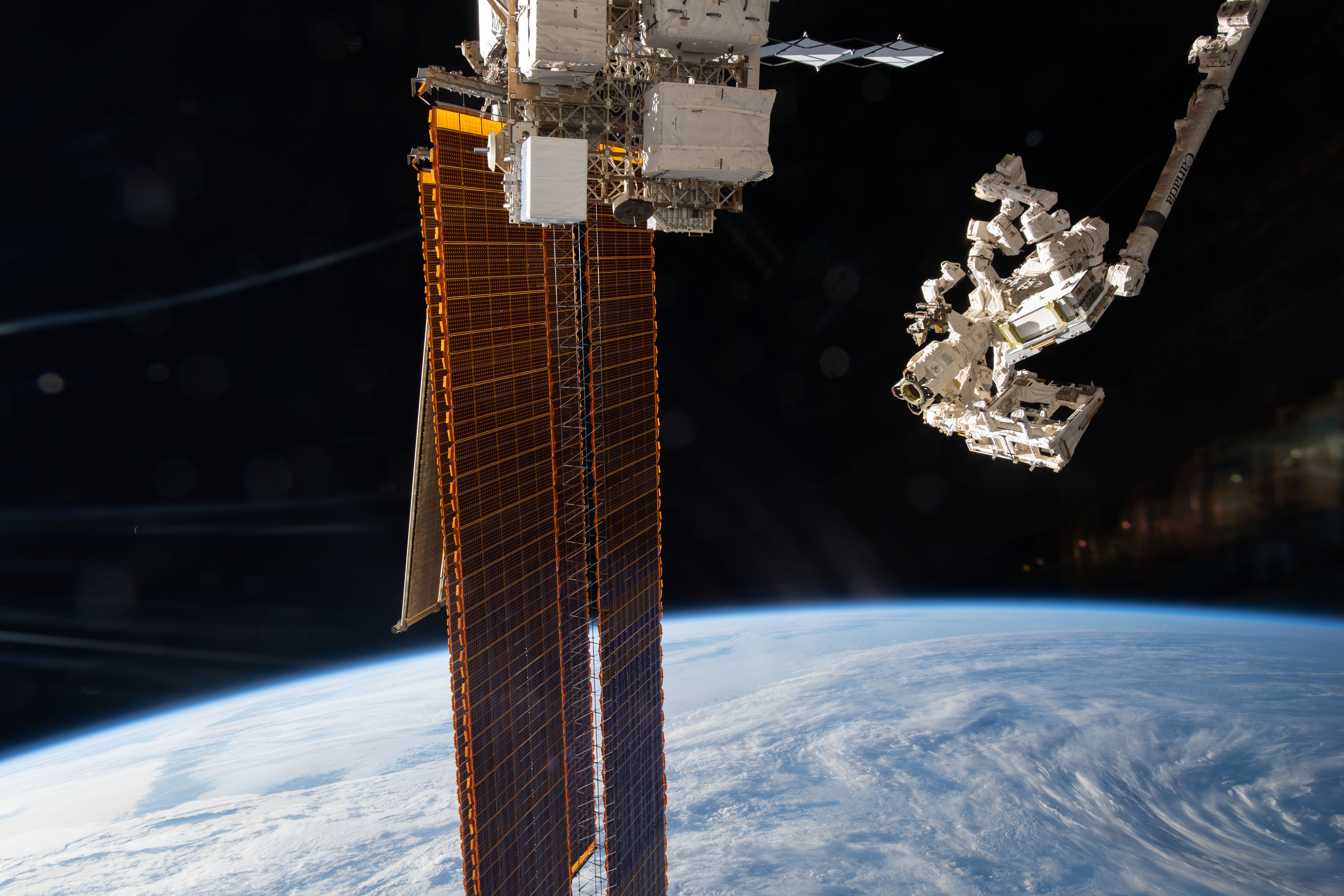
David Thompson: Sure. Well, of course, if you want to cover a lot of terrain on planet Earth, the easiest way to do that is from orbit, and a variety of different orbits that you can use…some are more challenging to reach than others. But it turns out that the International Space Station was a perfect match for the EMIT objectives, and the reason is that most of these dust-forming regions are arid, mid-latitude regions; that is, they concentrate around the Equator, and the ISS with its inclined orbit also covers this area of the globe, so it passes over these mid-latitude regions. And in fact, we discovered that based on our best estimates of where the mineral dust was coming from, we would be able to overfly all of those regions from the ISS. And of course, the ISS has lots of other advantages as a platform: it provides power, it provides data. And this really was a perfect match. So the instrument was originally designed in order to plug into the ISS and take advantage of these resources. And in turn, of course, we’d be downlinking data through the International Space Station, all of that existing infrastructure that would let us command the instrument more effectively and then recover the data.
Host: So what, what sorts of things that, did you work on that eventually led you to, you talked, it was, it was Robert actually that, that mentioned submitting a proposal about “here’s our idea for, we’re going to put this thing on the International Space Station”; talk about some of the work that you’ve done before that eventually led to the success of accepting the proposal from, from your design of the instrumentation to the confidence that NASA had that, you know, you could put it on the International Space Station, and this is, this would work and that your, your, your objectives and your goals were sound and that sort of thing. Talk about the approach that eventually led you to confidence in submitting to NASA and, and them saying yes.
David Thompson: Yeah. And it began far before our first proposal to the Earth Venture Instrument Program, which is the instrument program that ultimately funded EMIT to go to the space station. By the time we wrote the proposal, imaging spectroscopy was a mature technology. It had been tested many times before on a variety of different airborne platforms. And this is pretty typical of NASA instruments. Before you are able to put it into space, you first have to demonstrate, using some proxy, that you can do reasonable remote sensing. So there were, there’s a long history of campaigns for mineralogy, and many other objectives as well, using imaging spectrometers developed at JPL, that flew on a variety of different platforms. The high-altitude ER-2 aircraft that NASA flies, flew back and forth across California for many years, actually, doing geology and many other investigations as well. And we’ve worked with a variety of partners. The USGS for a long time has been our “boots on the ground” doing mineral validation campaigns, and then using these geologic data for their own purposes. And so there’s a long history of publication record, both in the journal literature and various conferences, that imaging spectroscopy works for studying the Earth surface and for minerals on, on the planet. And so we had good confidence, the algorithms were mature, and we’d been, had demonstrated that before we wrote the first proposal. And it didn’t go in the first time, actually: we wrote a proposal a couple years before and it was actually selected. So, as with all of these things, it takes time and refinement to make the ideas better and more precise. And the instrument evolved too. So initially, after selection, we had the concept that there would be a mirror that would allow us to point around at different targets; that was determined that that, that it was more efficient to just maintain a nadir-pointed perspective and that we’d be able to cover the entire terrain that we wanted to using that much simpler instrument. So the instrument design evolved as well, even after selection. But we are left now today in 2022 with quite a capable instrument, actually, and the first initial data that we’re getting is, is really quite promising. So it’s living up to our expectations as far as making these accurate measurements from space.
Host: Interesting. Yeah. Let’s dive into the design just, just a tad more, David, is, you, you talked about the, talking about a diff — couple different approaches to how exactly you’re going to get this imaging spectrometer on the International Space Station, and eventually there was one that met your needs and you talked about, you talked about a significant level of confidence in the instrument. Can you talk about just the, its design and how you get — I mean, you talked about you, you have some interesting areas of study that, that EMIT needs to look at, and you mentioned it gets to look at all of them. So how exactly is, is the design of EMIT that, that allows you to, to do that?
David Thompson: Yeah, well, there are a couple of different parameters that we need to consider in designing an instrument to meet these science objectives. So we start with a target, which is mineralogy on the surface. We want to be able to measure the distinct mineral absorption features to a given level of precision, because we decided as a science team that this is the accuracy we need, a 2% change in the relative depth of an absorption feature, in order to significantly advance our understanding for these, these Earth system models. So we began with this target, and then from there we could discern what kind of spectrometer we would need to build in terms of the, the signal-to-noise ratio that would be required, that is the, the sensitivity to subtle changes in surface reflectance that we would need to be able to measure. And so that gives us the approximate dimensions of the spectrometer and the optical layout, the kind of detector we would need, for instance. We knew that we needed to measure the wavelength range out into the shortwave infrared, because many of the minerals that we were interested in have distinctive unique signatures in that wavelength range. So that necessitated a cryogenic system that would be able to cool the detector cold enough that we would be able to measure those longer wavelengths. And then of course another dimension of the design that we worked on was the coverage that I alluded to before. So in order to cover all of these dust-forming regions of the world, we need a perspective that is the ISS orbit, and we need an instrument with a swath wide enough that we can collect enough data with each pass to ensure that that area is covered in a reasonable amount of time. And reasonable for our, in our case was a year of operations, and we hoped to be able to cover the key mineral dust-forming areas of the Earth long before that, that year is up.
Host: Very good. OK. So, yeah, you know, obviously it took a lot of work to get to, to that point. Did you by chance get to actually go to the launch and see all of your hard work and this thing that you’ve been dedicating so much time to actually leave the planet and head towards the space station?
David Thompson: Yep. Indeed, the entire team went down to see the launch. A couple of times, actually: the launch was initially delayed due to a challenge they had with the, the launch vehicle, but that was remedied and in the end we all got to see it launch on Bastille Day this year. It was absolutely spectacular, a twilight launch, the setting Sun illuminating the rocket plume as it launched off into space. We could see the exhaust illuminated and, it was truly spectacular. Of course, it was a little hair raising as well because that was our baby on top of that rocket, you know, that we’d spent years developing and, and refining and, and there it was on top of a controlled bomb, but it, it all’s well, and we arrived at the space station and, and were successfully installed. So it just went as smoothly as could be asked.
Host: Yeah, it was in the unpressurized trunk of SpaceX, right? It was, that’s where it was.
David Thompson: That’s right, yep.
Host: OK. So it had to be removed. Now, now, Rob, talk about the, the process of, yeah, removing this thing from the trunk, getting it installed, and that emotion that you felt whenever you started seeing the data come through, this thing, this thing was up and running, the science was beginning.
Robert Green: Yes. It, it was quite a remarkable process and that’s, again, one of the, the joys of the International Space Station, there are, there are wonderful steps along the way from launch to when you get plugged in, turned on, and get first light, more steps than you have in a typical mission maybe to Mars or to the Moon, for example. So I thoroughly enjoyed that. So again, we arrived at the space station in the trunk safely, that was step one. Then we wanted to wait until the solar beta angle, which is a description of how the Sun would land on EMIT when it was being transferred from the trunk to its site, was in a favorable regime. So we, we paused for a few days there, survival heaters EMIT was safe in the trunk. Then the conditions became right, and, and we were all glued to the Internet watching the arm reach back, grab EMIT, and then ever so slowly, I think this took about 60 hours, move deliberately, carefully planned, exquisitely planned, to its installation site. Along the way we had to pause again for the night and people to, to, to take a break, and so we connected another grapple to EMIT to provide extra power to make sure it was warm. There was a, a double grapple period while we waited for that to happen, the beautiful pictures of EMIT above the Earth, in this pause. Then we continued from that site the next morning to be installed, and, and we watched ourselves get loaded into the ELC (ExPRESS (Expedite the Processing of Experiments to Space Station) Logistics Carrier) – ELC Site 8 — ELC-1 Site 8 — and, and then ratcheted in. And then we got very quick feedback when it was powered on, that yes, we were seeing telemetry, we were seeing power and we were seeing high-rate data and we would see that we could command it. So that was just amazing. Those are things you got to have; if any of those aren’t true, there’s, there’s a problem…Houston. And so then we had to do the next steps, a little bit of decontamination, drive off any water that might be there that would frost up our cryocooler when it was turned on. So we, we waited a little while with heaters on to drive away the water; finished that. Then we had to take the next major step, which is take our instrument cold. It has to get down, the detector wants to get down to 160 Kelvin for us to see those wavelengths in the 2.5 or the shortwave infrared region. So we knew it was cold. And then we said, OK, where’s our first chance for illumination? It turns out it was in western Australia. And so, we knew the instrument was commanded to collect those data sets and subsequent ones; we had to wait, we knew it, the data were collected, they’re stored on the ISS, they have to come down to Huntsville and then moved over to JPL. And so I guess it was probably about 10 o’clock in the morning the next day, the first data were collected on the 28th of, of July, that we, we saw the first raw data sets, and they were exactly what I’d hoped. We had the image, and we had the spectrum. And all the spectrum was there with all the fingerprints of the Earth system, the ones we could easily see, which tend to be dominated by the atmosphere in the first order but even vegetation. So again, there was a tear in my eye that this was the culmination for me of more than 30 years, not just EMIT but the preceding years in this field of imaging spectroscopy, and the honor to, to lead this effort, to get this class of instrument looking at our planet for this important science and the other science it can enable.
Host: What an emotional time. Yeah. I mean, I, I just, I, I was, I was with you just with, on the emotion of, I, for me, I don’t know how you were, but as you were describing the 60 hours of this slow and careful maneuver of this very precious cargo, just hoping that, you know, everything went smoothly until it was installed, I mean, I was thinking about, like, 60 hours of basically white knuckling it, you know? I don’t know how you felt, but, you know, this is, this is your precious hardware that’s floating through space, and you mentioned like cool pictures and stuff, but how was that: was it, was it a tense 60 hours or was it very focused 60 hours?
Robert Green: I would say the competence of the teams that run the ISS and run the arm are so extraordinary that I really wasn’t concerned that, that…I was just reveling in it, and I continue to as it sends the data down. So again, there’s important touchstones; absolutely, if something isn’t what you expect, that’s an issue. This team, the team — JPL and, and the ISS team — will work the issue, and, and I had just this incredible confidence. So again, I wasn’t so concerned, but I was aware of what we were going through. The things needed to work right. I was pleased every step along the way, but boy, the team that built EMIT and the team that had taken care of it, which includes SpaceX getting it up there, is just magnificent. So again, maybe, I wouldn’t say I was foolish but I was always, I’m an optimistic guy too, so, I was always optimistic but realizing, you know, things don’t always go well, but we had the teams to address any glitches. And I won’t say there, there was a couple glitches along the way, but the team just focused on it and solved them. We built an instrument that has some resiliency as well. So, I was just thrilled when each checkpoint was cleared. And in fact we cleared almost all of them a little ahead of schedule, which was again, further evidence of, of the teams that are involved in this process. They’re excellent.
Host: Well, I’m, I’m, I’m glad to be talking to you so, so soon after you, you started getting your, that data from the, the first set of data from western Australia. This is only a couple of weeks after that — you said, I think it was July 28. So talk about, you know, you said, you said you had a tear come to your eye, you wiped it away, and it seems like it was time to buckle down and really get to the science and the measurements. And from what you, from what you alluded to in, in the beginning of our conversation here, it’s, it’s, it’s, you’ve been doing a lot, just a lot over these past couple of weeks.
Robert Green: Yeah. I want to hand it off to David because he is the, he is many contributions but the algorithms that take these raw data, which I can look at and I used to be able to write code that could process, he developed the algorithm, so he can talk maybe a little bit about what we quickly did with that first light data, which are raw data. It’s unprecedented to go to raw data to higher level products in hours, and have them, I will argue, look as good as they did that we could have the release with NASA elsewhere of the first light EMIT image cube, and radiant spectrum. But I guess I would, I would love David to speak about, a little bit more about that.
Host: Oh absolutely. Please take it away, David.
Robert Green: He was at the heart of it.
David Thompson: Sure. Well, just to set the stage, so EMIT operations, it actually begins with a period, but even before operations there’s a period called [i]n-orbit checkout or, IOC, and this’ll last about maybe a month after the installation, after EMIT is initially turned on and starts collecting data. So this is our time to take our own calibration measurements from space, to check out the instrument and all its different capacities, to make sure that we’re ready to begin the formal operations that will result in our, in our science objectives being met. So this is, this is our time now, as we’re speaking today, to test out the instrument and make sure that it’s functioning as we intended. And it really begins with a stable instrument. So, and JPL for a long time has been maturing the technologies of building an instrument that’s stable, that’s spectrally uniform, meaning it’s accurate across the entire field of view of the instrument, that it produces good, accurate spectra. So if you don’t have that, then all of the subsequent analysis are for naught, right? And we verified this in the laboratory when we still had EMIT here at the laboratory we would measure it by shining controlled stimulus into the instrument and then seeing how that hit the focal plane array, seeing that, the signals that the instrument would produce, to build up models of how the instrument responded to incoming illumination, and this is called the calibration process. So we would figure out what’s called the wavelength calibration, so what, what specific wavelength each channel of the instrument was sensitive to, and then a radiometric calibration, how the focal plane array responded to light, how sensitive it was to photons. And so these different aspects of calibration were rough-drafted during our laboratory measurements. And then, and then we let the instrument go. And there was a period where it sat in storage, where it was launched on a rocket, where it was floated through space, and the question on our minds when it was first turned on was, would the instrument have shifted, would our initial laboratory measurements hold? And so, as Rob said, when we first got our first light image and we saw a beautiful radiant spectrum, it was immediately apparent that yes, the instrument was completely stable, that it was more or less exactly as we had measured it in our laboratory. And that’s really what allowed us to produce those early products as quickly as we did, because the instrument was solid and because the, the measurements that we made before could be carried along. Now, of course, we’ll be making refinements. And so, the next couple of weeks will involve looking at different objects on the surface of the Earth, where we know a little bit about what we should be seeing, so that we can make adjustments in our, in our calibration to refine our understanding of how the instrument’s responding now that it’s on the space station. And so this, this process will continue. We’ll be refining the, the methods by which we produce what’s called the radiant spectrum, which is our, our measurement of illumination at the sensor. And then Rob alluded to the, the process by which that measurement is then analyzed in order to infer properties of the Earth’s surface, so we need to use that radiance, the incident illumination at the aperture, to estimate what the atmospheric state is, because we’re sensitive to all of that. As, as we discussed earlier in the methane conversation, all of the different constituency of the atmosphere leave their fingerprints on that spectrum, so we need to account for that as well. And that’s what gives us our, our measurement of the surface reflectance, roughly speaking the fraction of incident illumination of the surface that’s reflected back towards the sensor, and that’s where all of our interesting mineral features live. So the, the next subsequent stage of analysis after that is to look at the surface reflectant spectrum to figure out the abundance of various minerals that are on the surface within that pixel that EMIT is, is measuring. And that’s what allows us to create the mineral maps that will ultimately feed the Earth system models and give them updated estimates of surface mineralogy.
Host: And how long this is, this is going to be a pretty lengthy process, I assume, right? You’re going to have to, once, once you get to that point where you have that confidence in your instrumentation that you know, you’re going to be getting some, some really good data and, and you can have confidence in your instrument, how long is the process of actually measuring of, of, of day in, day out operations and generating those maps?
David Thompson: Yeah, well, I, I expect, I, I should say, actually, we already have pretty good confidence that EMIT is, is well-calibrated and is producing accurate data. There are always refinements that one can make; it’s kind of like tuning an instrument, right, and you want to keep updating it over time for every subtle shift because we’re very sensitive to even very, very tiny, you know, micron-level shifts in the focal plane array over time. So we’ll be, we’ll be tracking that very closely but it already looks very good. And then, of course, EMIT will start the process of science operations, measuring Earth’s mineral dust-forming regions whenever the ISS flies over, and that’s slated to take probably, well, several months actually, anywhere from four to six months, depending on cloud cover, in order to cover the entire dust-forming regions of the globe, at least once everywhere that we care about. Obviously, we can’t see through clouds, so that’s really the unknown in the equation: how many clouds will we encounter? But whenever there’s a clear sky we’ll be able to map that mineralogy and it will be, we’ll have that in our, in the bag thereafter. So that’s really what dictates how long it will take to finish the measurements.
Host: And then anything after is just sort of a nice to have, right, because you, six months, it’s not like you’re going to be flicking the switch on the off button quite, you know? If you, if you have the chance to continue to gather data and maybe fill in some of those gaps, just in case there’s too much cloud coverage, like, I’m assuming you can just keep going?
David Thompson: Absolutely, we’ll want to continue refining our measurements, taking validating measurements of places that we’ve already observed. There are a variety of different other objectives that other scientists might choose to pursue using the EMIT data, so I’m hoping that they can continue to use EMIT data products after our key mission objectives have been achieved. That’s obviously without, outside the purview of our own project but it, EMIT will be good for a lot of other things besides mineral dust.
Host: So as the, you know, all of your hard work, David, on the, on the instrument, right, I, I asked, you know, your level of confidence in the instrument and you said, oh, we’re, we’re pretty confident in the instrument, but I wonder is it because you had that sigh of relief whenever you’d actually did the initial checkouts, the on-orbit checkouts and it was as you expected, so I’m, I’m assuming you have had that sigh of relief of, all right, it’s working, we did it, but it’s, at this point you just mentioned, you know, just a, a couple of tweaks and refinements as you would normally do, but seems like you’ve gotten past what, what I assume to you, in your role in this, in this investigation is probably one of the more stressful events?
David Thompson: Yeah. We’re certainly over the threshold where we can say that EMIT is functioning as advertised, and we’ll be able to, to make those, those final tune-ups and, and get it working to perfect — we’re all kind of perfectionists here so we want to make sure that the data is accurate as possible. Fortunately, the planet is, given us all these beautiful calibration objects. The atmosphere with its gas absorption features gives us known wavelength positions of these features that we can calibrate against. And there are other parts of the surface that we can, we can use to calibrate other aspects of the system. So we’ll continue to use these, this physics knowledge of what we should be seeing in the atmosphere and on the surface to tweak our calibration as we go, but we’ve started with a very stable instrument. So, I don’t expect to have to update very much over the course of the mission.
Host: Very good. Now, Robert, as a principal investigator for this, you’re, I’m, I’m assuming you’re going into this with maybe some expectations, maybe some hopes, you know, as, as you’re going into the operations, actually starting to gather data and cover the whole area of Earth that is part of your objective. That is, you know, you, you really, this, this instrument is able to fill in the gaps of, of, what David mentioned is really everywhere you want to cover. So, as a principal investigator going into this, going into these next couple of months of data gathering, what are your hopes, what are your ambitions, what are your hypotheses of, of what you, what you expect and, and anticipate from this experiment?
Robert Green: Yeah, I’m just so excited to begin to look at the mineral maps that we produce and peel back this unknown of what is there, what’s coming off the Sahel, southern Sudan, other parts of Africa and Australia, South America, United States; what are those source regions? And then working closely with my colleagues on the science team who are running the Earth system models and starting to work our measurements in to close that gap and to increase the fidelity of the output. I’m just so excited. Every image that comes down is just spectacular — even ones with clouds, all that cloud, that’s amazing, look at those signatures. You know, David has done some work on understanding where clouds, or liquid water or ice; that’s revealed in the spectroscopy. While that’s not the focus of EMIT, we do get cloud images so we can look at that. But again, the surface mineralogy, the nature of this magical planet we live on, and in this case what minerals are at the surface and, and how are they likely to be in play as they get blown into the atmosphere and interact throughout their system, that’s what I’m, I’m looking forward to. Every day I get up, we have meetings every day on what’s going on with EMIT, what data, you know, David, and, and another colleague, Phil Brodrick, almost always have something to show about what we’ve seen in the latest data sets coming down as we’re in this early phase. And it’s incredibly exciting.
Host: Do you think that these data that you’re gathering, you talked about filling in the gaps of knowledge of, you know, surface mineralogy and, and, exactly what you’re looking at, you’re, you’re getting, you’re getting a lot of data across the whole Earth, and I wonder, you know, you may have some hypotheses going into it on, on, on how that can contribute to our overall under, overall understanding of the planet and climate science and, and all of these different things. But do you think there’s a chance that maybe these data can be available to other scientists to, so that they can maybe take that and run with some idea that maybe we haven’t even thought of yet? Do you think that these, that what, what EMIT is doing is going to contribute to a greater understanding of our planet in ways, maybe, we even haven’t even expected yet?
Robert Green: Absolutely. This will be the first data set of its class, and its kind for our planet. Now we’re not wall to wall, but we’re getting a big chunk of the planet with the highest quality spectra that have ever been measured, and that’s a benchmark: our planet is changing, so the sooner we get that data set, the better. Another point, from the very beginning in the EMIT proposal, was clear: we were required to make sure all the EMIT measurements and products were available to all scientists and interested parties who wanted to access those. So let me emphasize, all the EMIT data are going into NASA’s Land Processes DAAC (Distributed Active Archive Center) where anyone listening to this can access and download, but they aren’t there quite yet because we have to get valid products into the DAAC, but all EMIT measurements will be available for investigators to pursue whatever avenue they think that is worth pursuing. So we’re absolutely committed, and that’s actually part of NASA’s new thrust in open science; they, and, the Earth Science Division and the Science Mission Directorate at NASA, have a strong priority to make sure that our algorithms and everything we do with EMIT, our calibration, is accessible by everyone so they can learn from it and they possibly can help us improve it. So we’re absolutely working to make sure our measurements and our approach to processing those measurements are open to everybody to examine and take advantage of as we all try to move forward our understanding of this planet.
Host: So David, is that a task that maybe you have to really, really own? I know that you worked a lot on the actual, you know, instrumentation and the, and the, the software behind how the, how these data are coming in, but ultimately this has to be something that’s, that’s packaged and delivered and accessible to, as, as Rob is mentioning, to so many different scientists that may want to get their hands on this. So, so how are you approaching that? Taking, taking these data, there’s, and there’s going to be a lot, and, and organizing it, putting it together, displaying it in a fashion that that can be used by the science community?
David Thompson: Yeah, it’s a great question, and I think we can divide that into two parts. There’s the data itself, which will be handled by the, the NASA digital archive, and so we have a lot of help there from our colleagues at the archive to help format the data and distribute in a user-friendly format. And then there’s the code on the other side; Rob talked about us making our algorithms open as well. And here I think EMIT really differs from a lot of the missions that have come before. We’re pretty progressive, actually, in our use of open source, to the point where we’ve actually developed our code, when the EMIT mission was still in formulation and development, in an open-source environment, meaning that any university student who wanted to could go on to GitHub and download our entire science data system in whatever state it was in and try and reproduce that analysis on their own with all the associated data. So this is quite radical, actually, and has really helped us. So it wasn’t actually a burden at all. We did of course need to do some documentation so that our code was actually usable and legible to people who weren’t a part of the team, but it helped us far more than it was a burden in that other folks were able to use our code for other purposes; we’ve talked about other imaging spectrometers for airborne campaigns and other kinds of campaigns that could use these same algorithms in their data, which we consider to be best of class. And they’ve found things that we wouldn’t have found, so there are minor issues and bugs that other folks have found because we had more eyes on that code base, more people using it in a broader user community contributing. We are able to actually move forward much more quickly, I think, than otherwise. And it also benefits, I think for EMITs legacy, the eventual use of this code by other potential space missions and other individuals who want to use it for their own end. So it really is the property of everybody, all of the taxpayers who funded EMIT algorithm development, and we want it to be accessible to those people.
Host: I wanted to, I want to sort of end with, with a certain idea about why we do what we do, because I, you’re both, seem very passionate about this and very excited, right, and I think I’m catching you at just the right time, right, because it’s just that, you know, you’ve, you’ve already made these, these maneuvers and the data’s going to be coming in real soon; of course you got to make those tweaks but this is just a very exciting time. But if you pull back and think about the opportunities that, that NASA’s bringing to the science community to, to have the opportunity to, you know, get the funding to build such an instrument and put it on a place like the International Space Station in low-Earth orbit, and observe, and continue to do science and observe things, I think both of you maybe have a, have a good understanding bi, standing being in this world as to why we do what we do, why we, why we go to space, why we study different planets and, including our own, and, and, and add to the scientific community these data that, that can contribute to a better understanding of, of the, of Earth and, and even different planets, right, both of you have, have studied, not just the, not just the Earth, have, have, have studied other planetary bodies in the solar system, and I wonder what sort of drives you. Rob, if we can start with you: just sort of, if you think about what drives you and, and what inspires you to, to continue to pursue some of the things that you’re pursuing, and why you think it’s important?
Robert Green: Yeah. So, great…two parts that…why it inspired me. I guess, I grew up in a family with a scientist as a father, so I, I’ve been always clear that the scientific method is amazing in what it’s allowed us to move forward in our entire society and the technology that we’re all taking advantage of, including this one. Build on science and, and discoveries of testing hypotheses, trying to falsify them, then showing that we can’t falsify this one so let’s use it to go forward. That goes on forever. And right now we’re in an amazing age in, in space science in particular, where we can look outward to exoplanets with spectrometers, we can look through our solar system with spectrometers and other tools, and then we can look at our planet, which is just rich with spectral signatures that offer a host of new science hypotheses to test, whether it’s related to biodiversity, algal blooms, snow albedo, mineral dust, methane in the atmosphere. That, we do better as a society when we have evidence to base decisions on, and so science in some sense is a way to collect evidence, test, make sure it’s real evidence, and then make good decisions going forward. So I’m inspired at all those levels, but clearly discovery, seeing something for the first time that no one, in some cases, expected — water at low latitudes on the Moon, methane point sources, you know, as David described, it was his, his algorithms that did it in Four Corners — that’s inspiring. And then of course, the benefit to society is that we have good new information to make good new decisions as we go forward. And of course that’s incredibly fulfilling as well.
Host: Amazing. David I’ll pass to you for the same, for the same question, sort of what inspires you when, and how your perspective on why, what we do is important?
David Thompson: Sure. Well, I’d first echo everything that Rob said. I agree that information has this power to help humanity in an apolitical way. It’s just a uniformly good thing to have more information about how our, our planet functions, particularly in this age. So I think that’s critically important for me, but I also see a shift underway in the way that we look at the planet. Computers have become powerful enough that they can start to be partners in this exploration of Earth and other planets. And these, information machines, including imaging spectrometers, are now being deployed along with the help of, of powerful computers to measure our planet in dramatically new ways. And we’ve seen this reflected as well in a shift in priorities for the coming decade: NASA has slated a new Earth system observatory, that includes an imaging spectrometer component, called the Surface Biology and Geology investigation. And this will be an imaging spectrometer similar to EMIT, but that will cover the entire Earth terrestrial area and coastal aquatic zones every, every two weeks or so. And so, dramatic new data sets that will open new eyes on our planet, new forms of understanding. So this is just one aspect of this fundamental shift that I see in the way that we are observing our planet from space, and I want to be a part of that.
Host: [Laughter] That’s what I love about the, the scientific community, I get to have a lot of, a lot of you guys on the podcast, and it’s just, it seems like you always, you always want more, in like a very positive way, you know; it’s just like, there, we’re contributing, we’re learning a lot, but there’s always more, you know, we can, we, there’s more to do. And that level of excitement and that level of passion in the continuous pursuit of, of more knowledge and more science is just, is just inspiring to me, and I hope it is to our listeners as well. Rob and David, thank you so much for coming on Houston We Have a Podcast; this was very enlightening to learn about EMIT and everything that’s going on. And having you both on and, and your, your wild expertise in spectroscopy and some of the things that you’re contributing to this mission, wishing you the best of success and, and all the great things that EMIT is going to bring the scientific community. Thanks for coming on.
David Thompson: Thank you so much.
Robert Green: It’s been a tremendous pleasure.
[Music]
Host: Hey, thanks for sticking around. Really a pleasure talking with Rob and David today about EMIT, and learned a lot about what they’re doing and how we’re studying the Earth, that perspective from the International Space Station, some great stuff. You could check out more at NASA.gov/ISS to check out this experiment and many of the others that are happening aboard the orbiting complex. Of course, we are one of many NASA podcasts across the whole agency. You can check them all out at NASA.gov/podcasts; it’s there that you can find our entire collection. We even have other collections that we’ve split up into different episodes — we have a space station collection if you want to check out more of some of the research, we dive into a lot of specific experiments that are happening aboard the space station in many of our episodes. And you can check them all out, again, in no particular order. On social media, you can talk to us on the NASA Johnson Space Center pages, Facebook, Twitter, and Instagram. Just use the hashtag #AskNASA on your favorite platform to submit an idea or ask a question for the show, just make sure to mention it’s for us at Houston We Have a Podcast. This episode was recorded on August 9, 2022. Thanks to Will Flato, Pat Ryan, Heidi Lavelle, Belinda Pulido, and Jaden Jennings. And of course thanks again to Rob and David for taking the time to come on the show. Give us a rating and feedback on whatever platform you are listening to us on and tell us what you think of our podcast. We’ll be back next week.