


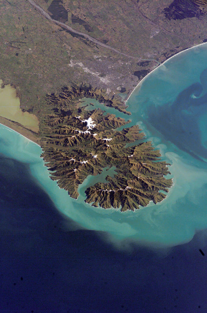
During its tenure aboard the International Space Station, Expedition 13 passed a major milestone: as of late August 2006, more than one quarter of a million images of Earth had been taken from the ISS. The rate at which Expedition 13 photographed the Earth was record-setting, as the crew passed the 200,000 image mark less than two months before. The 250,000th image is this oblique view of the city of Christchurch, New Zealand. The oblique view provides a sense of perspective and accents topography, in contrast to nadir (directly downwards) views.
Snow highlights the peaks of the Banks Peninsula to the southeast of the city. The peninsula has a radically different landscape compared to the adjoining, flat Canterbury Plains, where Christchurch (gray patch to the north) is located. The Banks Peninsula is formed from the overlapping cones of the extinct Lyttelton and Akaroa volcanoes. Subsequent erosion of the cones formed the heavily dissected terrain visible in the image, and sea level rise led to the creation of several harbors around the Peninsula. Erosion continues unabated today, as evidenced by the apron of greenish blue, sediment-laden waters surrounding the Banks Peninsula.
Other interesting features in the image include the braided Waimakariri River to the north-northwest of the city, and the greenish brown waters of Lake Ellesmere at image left. The coloration of the water is due both to its shallow depth (1.4 meters on average, or about 4.5 feet) and its high concentrations of nitrogen and phosphorus, which fertilizes the growth of large amounts of green algae.Image credit: NASA