


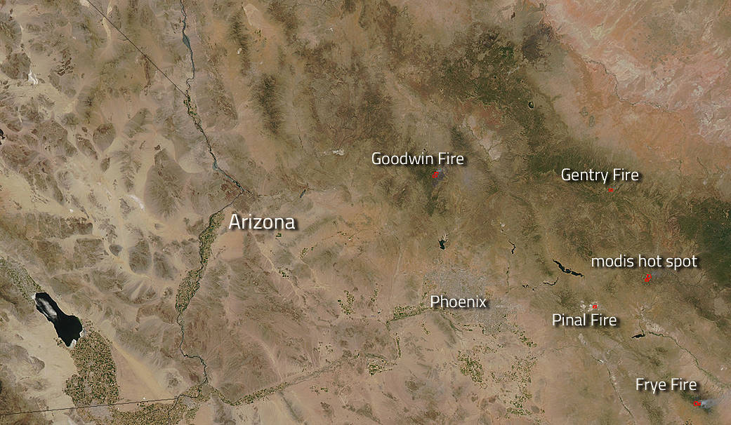
Wildfires have been plaguing the southwestern United States with hot, dry weather, high winds and lightning strikes. The interesting point to note in this image is the “modis hot spot” highlighted area. This is a spot on the ground that the MODIS instrument aboard both the Aqua and Terra satellites has recognized as having temperatures higher than the background. When accompanied by plumes of smoke, as in this image, such hot spots are diagnostic for fire. This tool is essential in helping firefighters pinpoint and target wildfires, especially in remote areas where they may not have even been reported. The earlier they can begin to fight the fire, the more quickly the fire can be contained and extinguished.
The Goodwin fire has been burning since June 24 and its cause is still under investigation. This fire is the only fire on this map that was not caused by a lighting strike. There are 752 personnel fighting this fire which is at present 25% contained. Several areas around the fire have been evacuated for the safety of the residents. Current weather conditions are slightly higher in humidity but winds still continue to plague firefighters and spread fire.
The Gentry fire began with a lightning strike on June 28 and has already grown to 100 acres. The fire is in the Black Mesa Ranger District of the Apache-Sitgreaves National Forests in Navajo County. The fire is being fueled by dead and down vegetation and brush. There are 50-60 personnel assigned with moderate growth potential forecasted.
The Pinal fire began back on May 8 with a lightning strike and has grown to 7,193 acres. It is located 6 miles south of Globe, Arizona and is 95% contained. The forecast for the area is for hot, dry weather for the near future. Fuel moisture remains critically low. Smoke and possible flames are probable within the fire’s perimeter until the area receives significant moisture.
The Frye fire is the largest of the fires at 39,993 acres in size. This fire began on June 7 with a lightning strike on the north and south sides of Mt. Graham. Over 790 personnel are assigned to this fire and it is currently 45% contained. Hot and dry weather will continue over the fire through Saturday with increasing wind speeds on Saturday. Wind is a factor that often plagues firefighters because of its ability to aid the spread of fire quickly, often changing direction and putting firefighters at risk.
NASA’s Aqua satellite collected this natural-color image with the Moderate Resolution Imaging Spectroradiometer, MODIS, instrument on June 29, 2017. NASA image courtesy Jeff Schmaltz LANCE/EOSDIS MODIS Rapid Response Team, GSFC. Caption by Lynn Jenner with information from Inciweb and the U.S. Wildfire Activity Public Information map.