


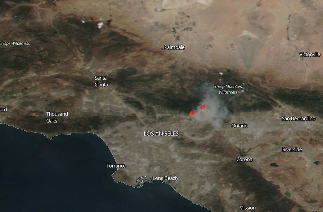
Extreme heat and dry conditions contributed to the start of the Reservoir Fire and Fish Fires located just north of Los Angeles. The Reservoir blaze began on June 20, 2016 at approximately 11 a.m. and the start of the fire is still under investigation. Currently, the fire is 2,400 acres with 0% containment and 234 personnel are on scene. San Gabriel Canyon is being evacuated along with the communities of Mountain Cove, Camp Williams, and Glendora Mountain Road. The main fuel is chaparral, brush, and short grass. Extreme fire behavior has been reported with long-range spotting and uphill runs. Structures are threatened and as such evacuations (as noted above), road and area closures are in effect.
The Fish Fire began at approximately the same time as the Reservoir Fire. It was noted as being 2,500 acres in size in the National Interagency Fire Center’s (NIFC) daily report for June 21 with 376 personnel currently battling the blaze. The NIFC for fires is managing the Fish fire located two miles northeast of Azusa, CA. The current fuel feeding the fire is chaparral, brush, and tall grass. Extreme fire behavior has been noted with spotting and running. Numerous structures threatened and mandatory evacuations for road, area and trails are in effect.
The smoke from the fires can be seen clearly in the Los Angeles area and could pose health hazards as the fires grow. The smoke released by any type of fire (forest, brush, crop, structure, tires, waste or wood burning) is a mixture of particles and chemicals produced by incomplete burning of carbon-containing materials. All smoke contains carbon monoxide, carbon dioxide and particulate matter or soot and is hazardous to breathe.
NASA’s Aqua satellite collected this natural-color image with the Moderate Resolution Imaging Spectroradiometer, MODIS, instrument on June 20, 2016, 2013. Actively burning areas, detected by MODIS’s thermal bands, are outlined in red. NASA image courtesy EOSDIS MODIS Rapid Response Team, GSFC. Caption by Lynn Jenner with information from NIFC and Inciweb