


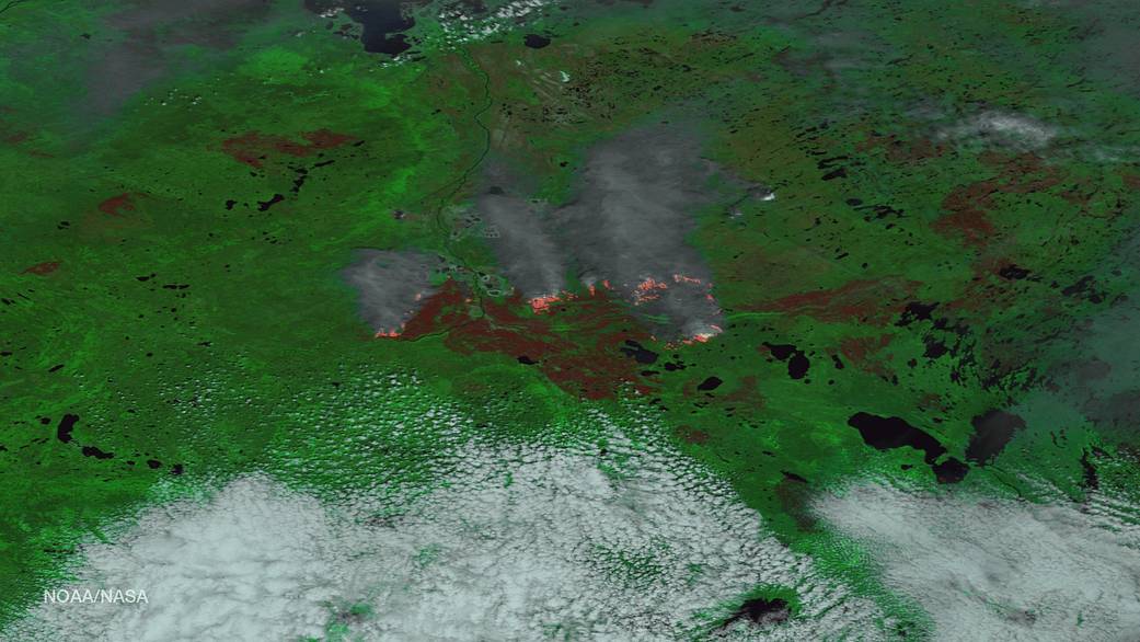
Clear skies during the Suomi NPP satellite’s pass over the Fort McMurray Fire area show the blaze is still raging in the Canadian Province of Alberta. The Alberta Ministry of Agriculture and Forestry reports that the wildfire is now estimated to be over 522,892 hectacres in size (or 1,292,094 acres– an area larger than the entire state of Rhode Island). There are currently 1,267 wildland firefighters, 57 helicopters, and 186 pieces of heavy equipment being used to battle the blaze, with more expected to arrive over the next few days. In total, the province plans to add an additional 1,000 firefighters over the next two weeks.
This enhanced image, taken by the Suomi NPP satellite on May 24, 2016, uses multiple channels on its VIIRS instrument, including visible and thermal imagery, to distinguish cloud, smoke, land, and areas of active fires. The fire’s thermal signature is so strong, and the burned area so large, that it is easily detected by the satellite’s sensors, 512 miles above the Earth’s surface.
For the most recent Fort McMurray Fire update, visit The Alberta Ministry of Agriculture and Forestry.
This image was taken by the Suomi NPP satellite’s VIIRS instrument around 2035 UTC on May 24, 2016. Credit: NOAA/NASA Caption information: Canadian Wildland Fire Information System