


Satellite View of Remnants of Post-Tropical Cyclone Niala
Post-Tropical Cyclone Niala faded under a hostile atmospheric environment and an infrared satellite image shows the torn-apart storm’s remnants southwest of Hawaii.
NOAA’s Central Pacific Hurricane Center (CPHC) issued the final bulletin on Niala at 0300 UTC (11 a.m. EDT on Sept. 28). At that time the center was about 405 miles south of Honolulu, Hawaii and moving to the west-northwest. Niala ceased to qualify as a tropical cyclone.
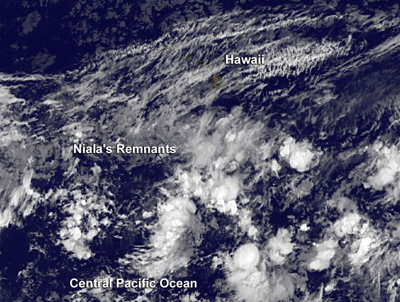
NOAA’s GOES-West satellite provided an infrared image of the remnant clouds associated with what was once Tropical Cyclone Niala. In the image, the remnants appear as shapeless clouds covering a large area southwest of Hawaii, although an area of thunderstorms persisted around post-tropical/remnant low. The image was taken on September 29, 2015 at 1200 UTC (8 a.m. EDT/2 a.m. HST).
CPHC said that hostile shear environment is expected to prevent re-development in this area for the next few days.
Rob Gutro
NASA’s Goddard Space Flight Center
Sep. 28, 2015 – NASA’s RapidScat Spots Tropical Storm Niala’s Waning Winds
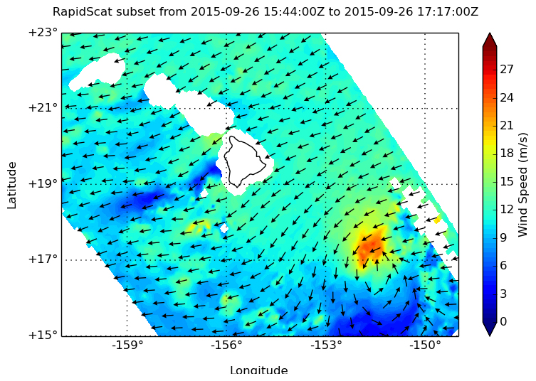
The RapidScat instrument saw the strongest winds in the Central Pacific Ocean’s Tropical Storm Niala were on the northwestern side, facing the Big Island of Hawaii while the rest of the storm was below tropical-storm strength.
At 1 p.m. EDT on September 26 the International Space Station (ISS) passed over Tropical Storm Niala. The RapidScat instrument that flies aboard ISS identified the strongest area of sustained winds in the northwestern quadrant of the storm at a rate of 24 meters per second (53.6 mph/86.4 kph). Sustained winds around the rest of the system were a lot weaker, near 9 meters per second (20 mph/32 kph) or less.
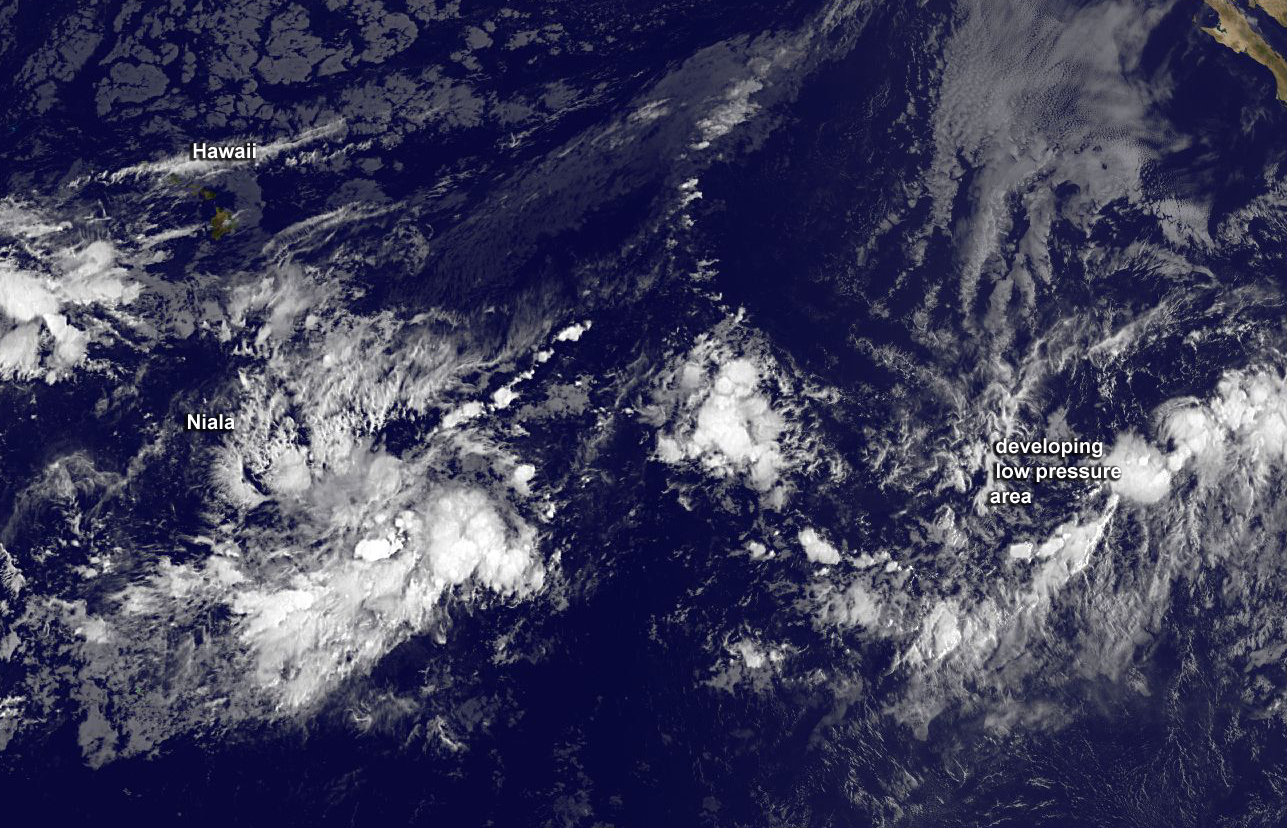
By Sept. 28 at 11 a.m. EDT, when NOAA’s GOES-West satellite captured an infrared image of the storm south of the Big Island of Hawaii, Niala had weakened to a tropical depression. To the east of Niala is a developing tropical low pressure area.
The National Hurricane Center said that environmental conditions are expected to be conducive for development of that system, and a tropical depression is likely to form later this week while the low moves east-northeastward to northeastward.
At 11 a.m. EDT (5 a.m. HST/1500 UTC) on September 28, the center of Tropical Depression Niala was located near latitude 15.0 north and longitude 156.8 west. That puts the center of Niala about 440 miles (710 km) south of Honolulu, Hawaii and about 850 miles (1,370 km) east of Johnston Island.
The depression was moving toward the west-southwest near 8 mph and is expected to continue in that general direction for the next day. Maximum sustained winds were near 35 mph (55 kph) and additional weakening is expected during the next couple of days.
NOAA’s Central Pacific Hurricane Center expects Niala to weaken to a remnant low later in the day on September 28.
Rob Gutro
NASA’s Goddard Space Flight Center
Sep. 25, 2015 – NASA Sees Wind Shear Affecting Tropical Storm Niala
NASA’s Aqua satellite saw wind shear was affecting newborn Tropical Storm Niala as it continued moving through the Central Atlantic Ocean.
Despite wind shear, Tropical Depression 6C formed about 500 miles southeast of Hilo, Hawaii at 11 p.m. EDT on September 24, 2015. By 11 a.m. EDT, the depression strengthened into a tropical storm and was renamed Tropical Storm Niala.
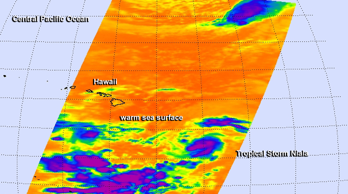
On Sept. 24 at 7:47 a.m. EDT the Atmospheric Infrared Sounder or AIRS instrument aboard NASA’s Aqua satellite provided an infrared look at developing Tropical Depression 6C. AIRS data showed that northwesterly vertical wind shear was pushing clouds and strongest storms with coldest cloud tops to the southeast of the center. Cloud top temperatures were as cold as -63 Fahrenheit/-53 Celsius, indicative of strong storms with the potential for heavy rain. The AIRS infrared data also showed that the system was moving through warm waters near 28 to 29 Celsius (82.4 to 84.2 Fahrenheit) which helped it strengthen into a depression and later into a tropical storm.
NOAA’s Central Pacific Hurricane Center noted that the most recent guidance from University of Wisconsin-CIMSS and ships for current vertical wind shear in the vicinity of Niala, suggest that there is moderate shear of about 15 knots (17.2 mph/27.8 kph) from the northwest.
At 5 a.m. EDT (0900 UTC) on September 25 the center of Tropical Storm Niala was located near latitude 15.1 north and longitude 150.1 west. That’s about 490 miles (790 km) southeast of Hilo, Hawaii. Maximum sustained winds are near 35 knots (40 mph/65 kph) and gradual intensification is expected during the next two days.
NOAA’s Central Pacific Hurricane Center noted that Niala was moving toward the northwest near 7 mph (11 kph). TD6C is expected to gradually turn toward the west-northwest then west on Saturday, September 26 and pass far south of the Big Island of Hawaii.