


Satellite Sees Remnants of Tropical Depression Javier
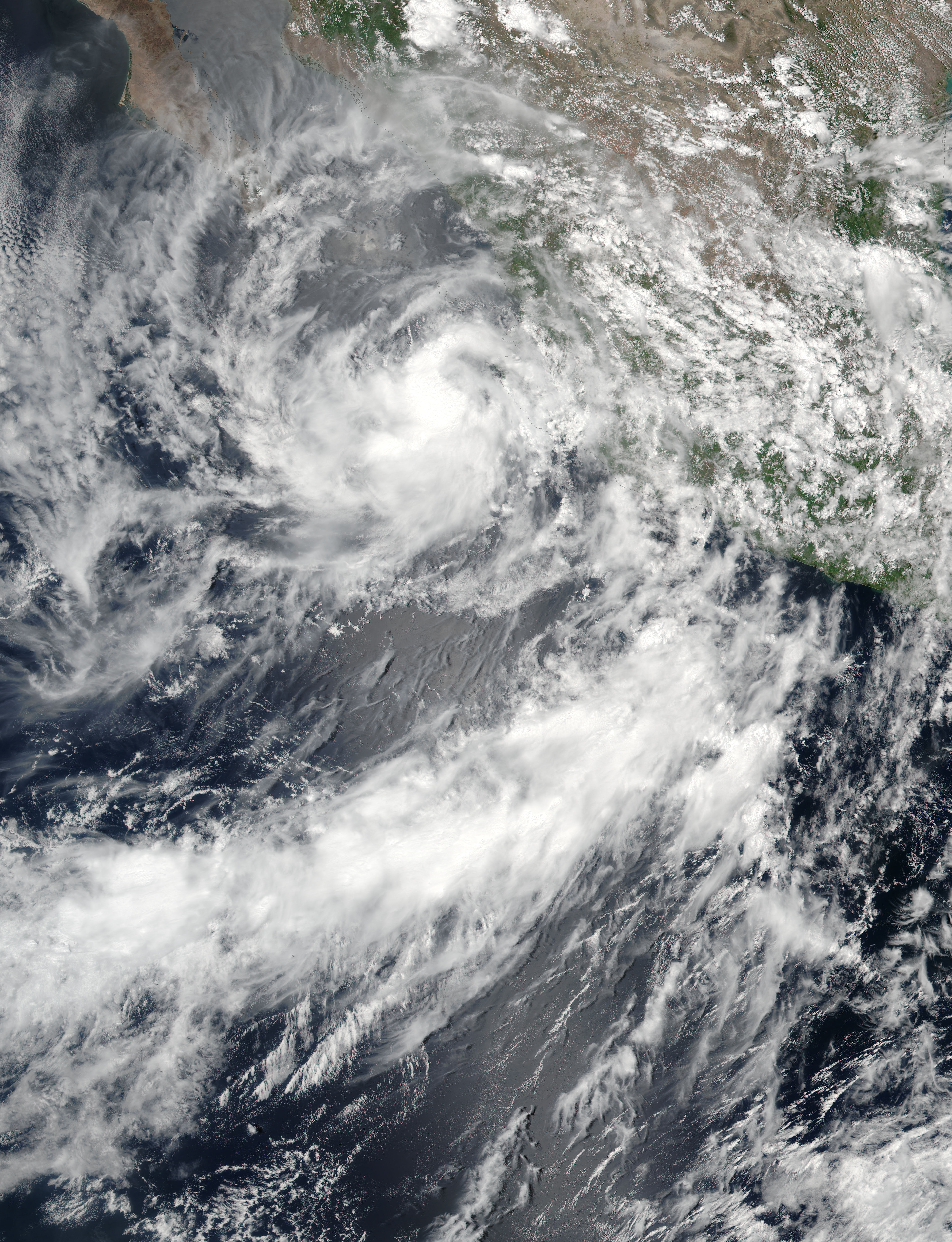
Tropical Depression Javier weakened to a remnant low-pressure area on Aug. 9 at 5 p.m. EDT (2100 UTC). NOAA’s GOES-West satellite showed the remnants over Baja California, Mexico, and the Gulf of California.
The National Hurricane Center (NHC) noted in the Eastern Pacific discussion on Aug. 10 that “Satellite-derived winds and surface observations indicate winds in the vicinity of Javier have decreased to 15 knots or less. The same satellite-derived wind imagery indicates winds between 23 to 28.7 mph (20 to 25 knots/37 to 46.3 kph) over the northern Gulf of California, north of 25 degrees north latitude.”
A NOAA GOES-West infrared image of the remnants of Javier in the Gulf of California was taken on Aug. 10, 2016, at 8:30 a.m. EDT (1230 UTC). The GOES-West image showed very weak storms over Baja California and the Gulf. The remnant low of Javier is currently located north of Cabo San Lazaro, Mexico.
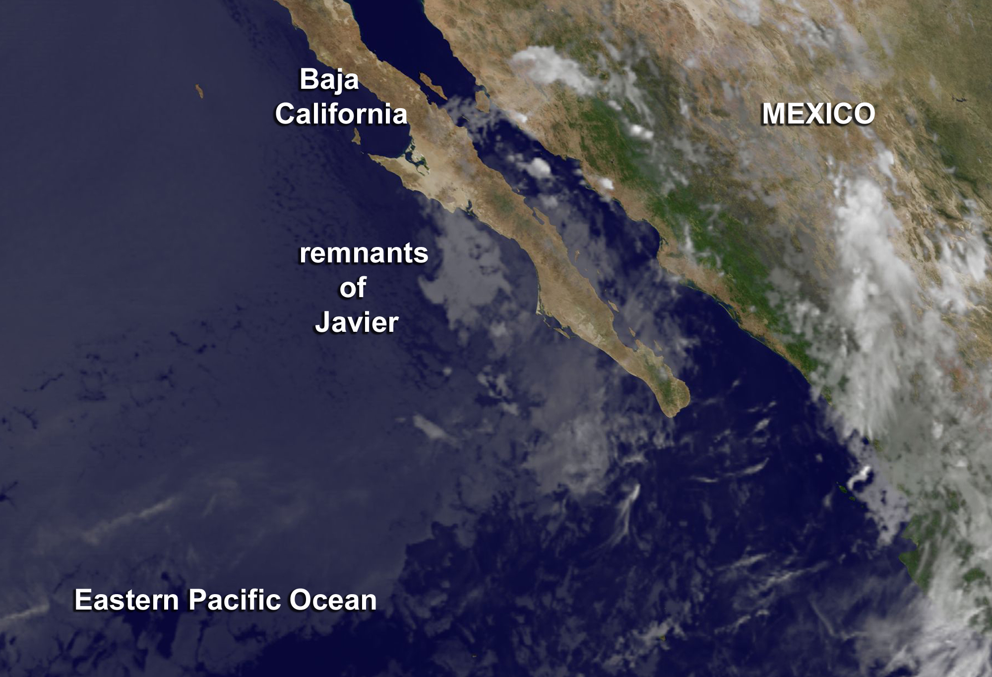
The GOES image was generated at the NASA/NOAA GOES Project at NASA’s Goddard Space Flight Center in Greenbelt, Maryland.
Javier’s remnants are expected to produce storm rainfall of 2 to 4 inches over Baja California Sur and northwestern Mexico through Thursday morning, Aug. 11, with maximum rainfall totals as much as 8 inches.
NHC noted that moisture partially related to Javier has spread into Arizona and New Mexico, where 2 to 4 inches of rain, with isolated amounts of up to 8 inches, are possible through Thursday. The remnant low will continue to weaken as it moves to the north-northwest along the southern Baja California peninsula for the next day or so until it dissipates.
By Rob Gutro
NASA’s Goddard Space Flight Center, Greenbelt, Md.
Aug. 9, 2016 – NASA Spots Tropical Storm Javier at Southern Tip of Baja California
When Tropical Storm Javier was closest to the southern tip of Baja California, Mexico, NASA-NOAA’s Suomi NPP satellite passed overhead from space and provided a look at the storm’s extent. Today, Aug. 9, Javier has weakened to a depression.
On Aug. 8 at 4 p.m. EDT (20:00 UTC) the Visible Infrared Imaging Radiometer Suite (VIIRS) instrument aboard NASA-NOAA’s Suomi NPP satellite captured this visible light image of Tropical Storm Javier near the southern tip of Baja California, Mexico. The image showed the center of Javier just southeast of the Baja, while a fragmented band of thunderstorms were dropping heavy rainfall over land.
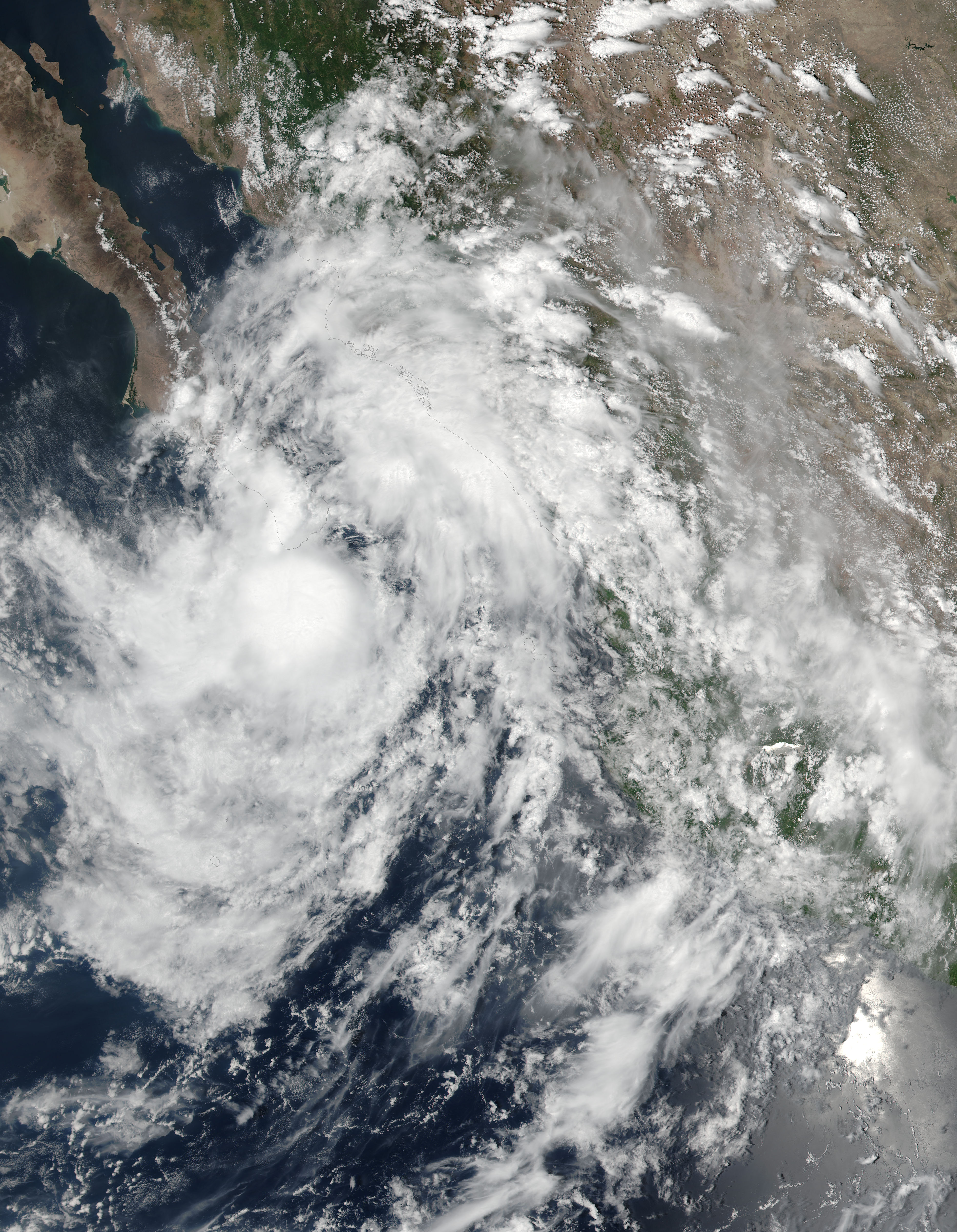
By Aug. 9 at 8 a.m. EDT (1200 UTC), the government of Mexico discontinued the tropical storm warning and tropical storm watch for the Baja California peninsula as Javier moved to the northwest and away from land.
At 8 a.m. EDT (1200 UTC) the center of Tropical Depression Javier was located near 23.4 degrees north latitude and 110.6 degrees west longitude. That’s about 50 miles (85 km) northwest of Cabo San Lucas, Mexico. Javier is moving toward the northwest near 6 mph (9 kph), and the National Hurricane Center (NHC) said this general motion is expected to continue through Wednesday.
Maximum sustained winds have decreased to near 35 mph (55 kph) with higher gusts. Tropical-storm-force winds extend outward up to 45 miles (75 km) from the center.
On the forecast track, the center of Javier is expected to move near or over Baja California Sur through Wednesday. Additional weakening is expected during the next couple of days, and Javier is forecast to become a remnant low within the next day or so.
By Rob Gutro
NASA’s Goddard Space Flight Center, Greenbelt, Md.
Aug. 8, 2016 – NASA Sees Tropical Storm Javier Form in the Eastern Pacific
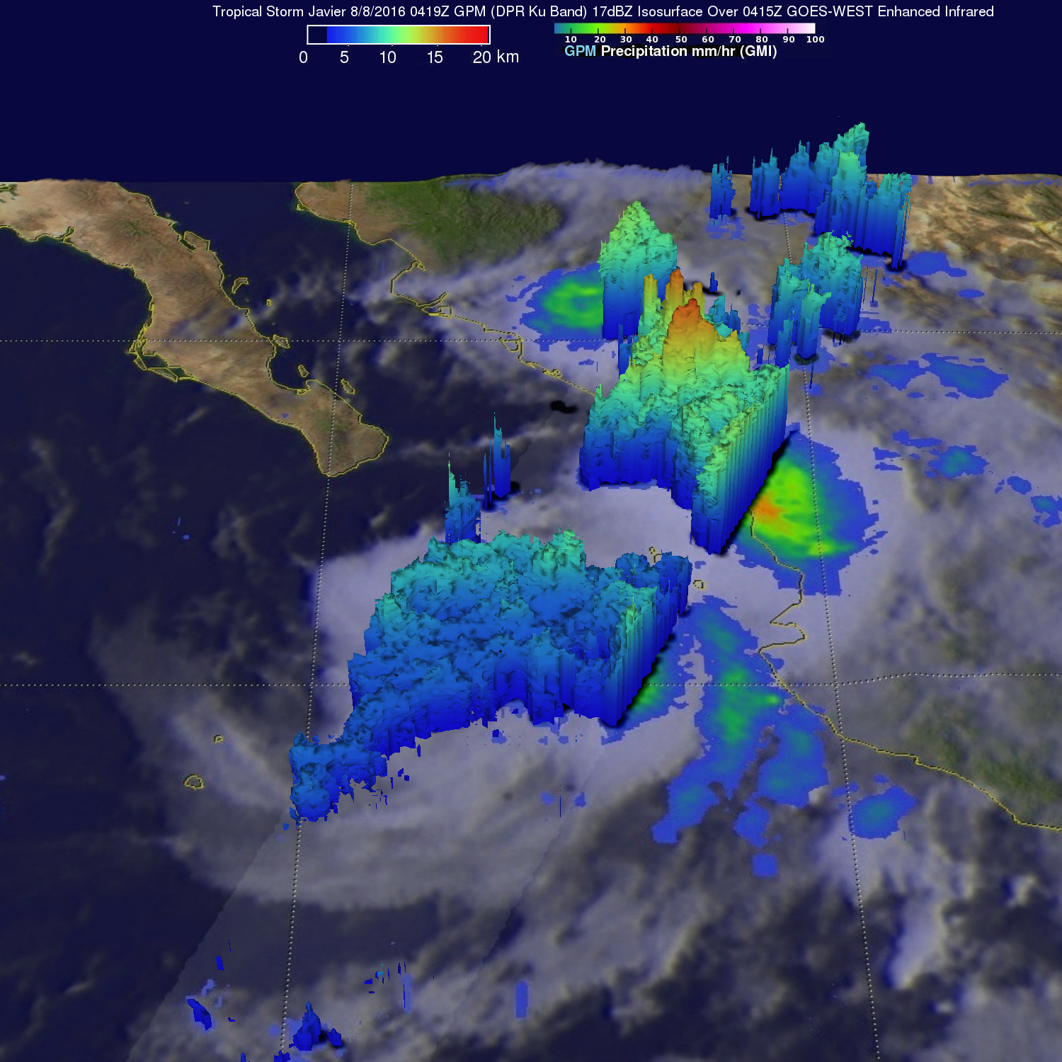
Tropical Storm Javier formed on Aug. 7, 2016 in the Eastern Pacific Ocean off Mexico’s western coast. Javier formed partially from the remnants of Hurricane Earl. NASA’s Global Precipitation Measurement core satellite found that Javier contained heavy rain. On Aug. 8, Javier triggered hurricane and tropical storm warnings.
Landslides caused by heavy rainfall from the remnants of Hurricane Earl caused the reported deaths of at least 39 people in eastern Mexico. That kind of rainfall was now seen in Tropical Storm Javier.
The Global Precipitation Measurement mission, or GPM core observatory satellite, flew above Tropical Storm Javier on Aug. 8, 2016 at 12:19 a.m. EDT (0419 UTC). Rainfall was analyzed using GPM’s Microwave Imager (GMI) and Dual-Frequency Precipitation Radar (DPR) instruments. Those data showed that Javier was producing heavy rainfall both near the center of the tropical storm and also near Mexico’s coast northeast of Javier. Rain was measured by DPR falling at a rate of over 4.1 inches (103 mm) per hour near Javier’s center of circulation. Precipitation was also calculated by GPM’s GMI to be coming down at a rate of almost 2.4 inches (60 mm) per hour near Mazatlán, Mexico.
The National Hurricane Center expects that heavy rainfall to affect warning areas. Javier is expected to produce total rain accumulations of 3 to 6 inches over coastal parts of the Mexican states of Sinaloa and southern Sonora into Baja California Sur with possible isolated maximum amounts of 10 inches through Wednesday morning.
GPM’s Radar (DPR Ku band) found that storm tops’ heights were highest near Mexico’s coast. Three-dimensional measurements of precipitation near Javier’s center showed storm tops were above 8.1 miles (13 km) while tall storms near Mexico’s coast reached altitudes above 10.5 miles (17 km). GPM is a joint mission between NASA and the Japanese space agency JAXA.
On Aug. 8, the National Hurricane Center posted a hurricane warning from Los Barriles to Todos Santos, Mexico. A hurricane watch is in effect from Todos Santos to Cabo San Lazaro. In addition, a tropical storm warning is in effect for Los Barriles to San Evaristo and Todos Santos to Cabo San Lazaro. A tropical storm watch is in effect for San Evaristo to Loreto Cabo San Lazaro to Puerto San Andresito.
At 11 a.m. EDT (1500 UTC), the center of Tropical Storm Javier was located near 22.0 degrees north and 109.2 degrees west longitude. That’s about 75 miles (125 km) southeast of Cabo San Lucas, Mexico. Javier is moving toward the northwest near 10 mph (17 kph), and this motion with a decrease in forward speed is expected through Tuesday. On the forecast track, the center of Javier is forecast to pass near or over the southern tip of the Baja California peninsula later today, and move near the west coast of Baja California Sur tonight and Tuesday. Maximum sustained winds are near 50 mph (85 kph) with higher gusts. Some strengthening is possible while Javier passes near the extreme Baja California peninsula.
For updated forecasts, visit the NHC website: www.nhc.noaa.gov
Hal Pierce/Rob Gutro
NASA’s Goddard Space Flight Center, Greenbelt, Md.