


On Thursday, NASA released the first data maps from its new instrument launched to space earlier this year, which now is successfully transmitting information about major air pollutants over North America. President Biden and Vice President Harris believe that all people have a right to breathe clean air. Data from the TEMPO mission will help decision makers across the country achieve that goal and support the Biden Administration’s climate agenda — the most robust climate agenda in history.
From its orbit 22,000 miles above the equator, NASA’s TEMPO, or Tropospheric Emissions: Monitoring of Pollution, is the first space-based instrument designed to continuously measure air quality above North America with the resolution of a few square miles.
“Neighborhoods and communities across the country will benefit from TEMPO’s game-changing data for decades to come,” said NASA Administrator Bill Nelson. “This summer, millions of Americans felt firsthand the effect of smoke from forest fires on our health. NASA and the Biden-Harris Administration are committed to making it easier for everyday Americans and decisionmakers to access and use TEMPO data to monitor and improve the quality of the air we breathe, benefitting life here on Earth.”
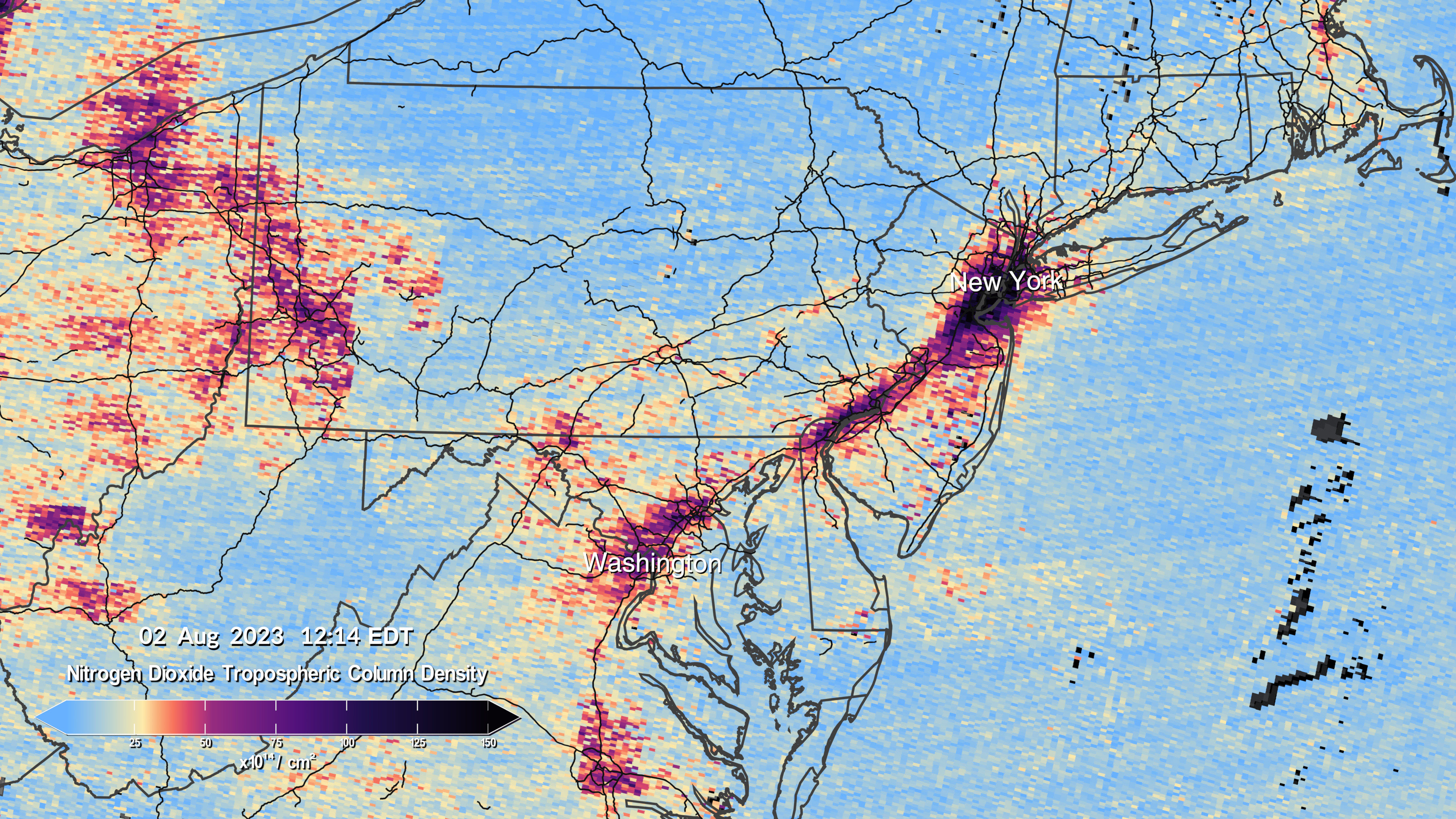
 This pair of images shows nitrogen dioxide levels over the DC/Philadelphia/New York region at 12:14 and 4:24 p.m. on August 2, as measured by TEMPO.Credits: Kel Elkins, Trent Schindler, and Cindy Starr/NASA’s Scientific Visualization Studio
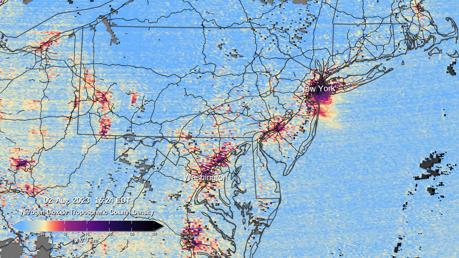
Observations by TEMPO will significantly improve studies of pollution caused by rush-hour traffic, the movement of smoke and ash from forest fires and volcanoes, and the effects of fertilizer application on farmland. In addition, TEMPO data will help scientists evaluate the health impacts of pollutants and aid in the creation of air pollution maps at the neighborhood scale, improving understanding of disparities in air quality within a community. Data will be shared with partner agencies that monitor and forecast air quality, such as the Environmental Protection Agency and the National Oceanic and Atmospheric Administration.
Launched in April aboard a Maxar Intelsat 40e satellite on a SpaceX Falcon 9 rocket, TEMPO makes hourly daytime scans of the lower atmosphere over North America from the Atlantic Ocean to Pacific coast and from roughly Mexico City to central Canada. The primary instrument is an advanced spectrometer that detects pollution normally hidden within reflected sunlight.
The science mission is a collaboration between NASA and the Smithsonian Astrophysical Observatory (SAO) in Cambridge, Massachusetts.
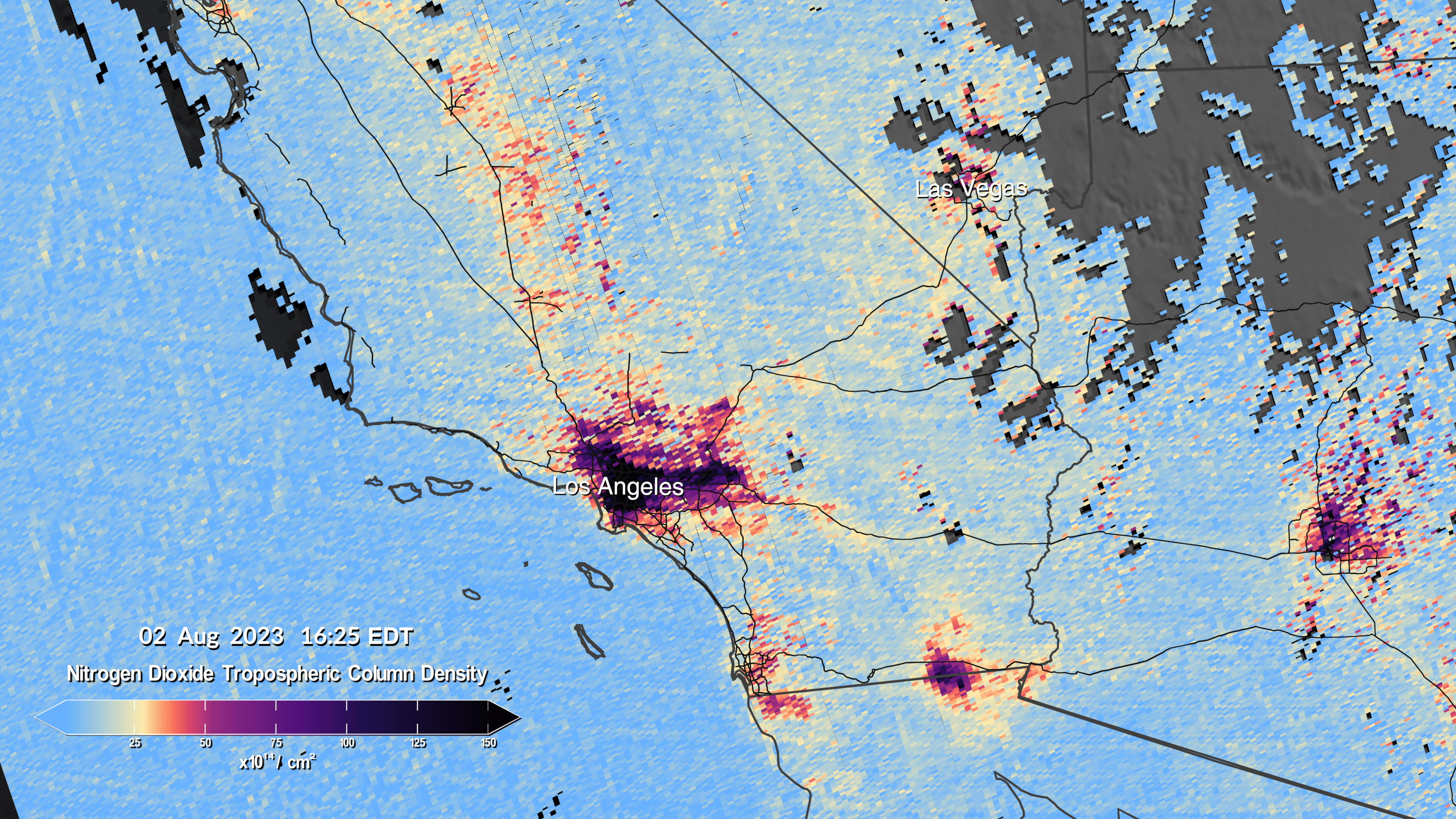
The first pollution maps released by NASA from the mission show concentrations of nitrogen dioxide gas from pollution around cities and major transportation arteries of North America. TEMPO measures sunlight reflected and scattered off Earth’s surface, clouds, and atmosphere. Gases in the atmosphere absorb the sunlight, and the resulting spectra are then used to determine the concentrations of several gases in the air, including nitrogen dioxide.
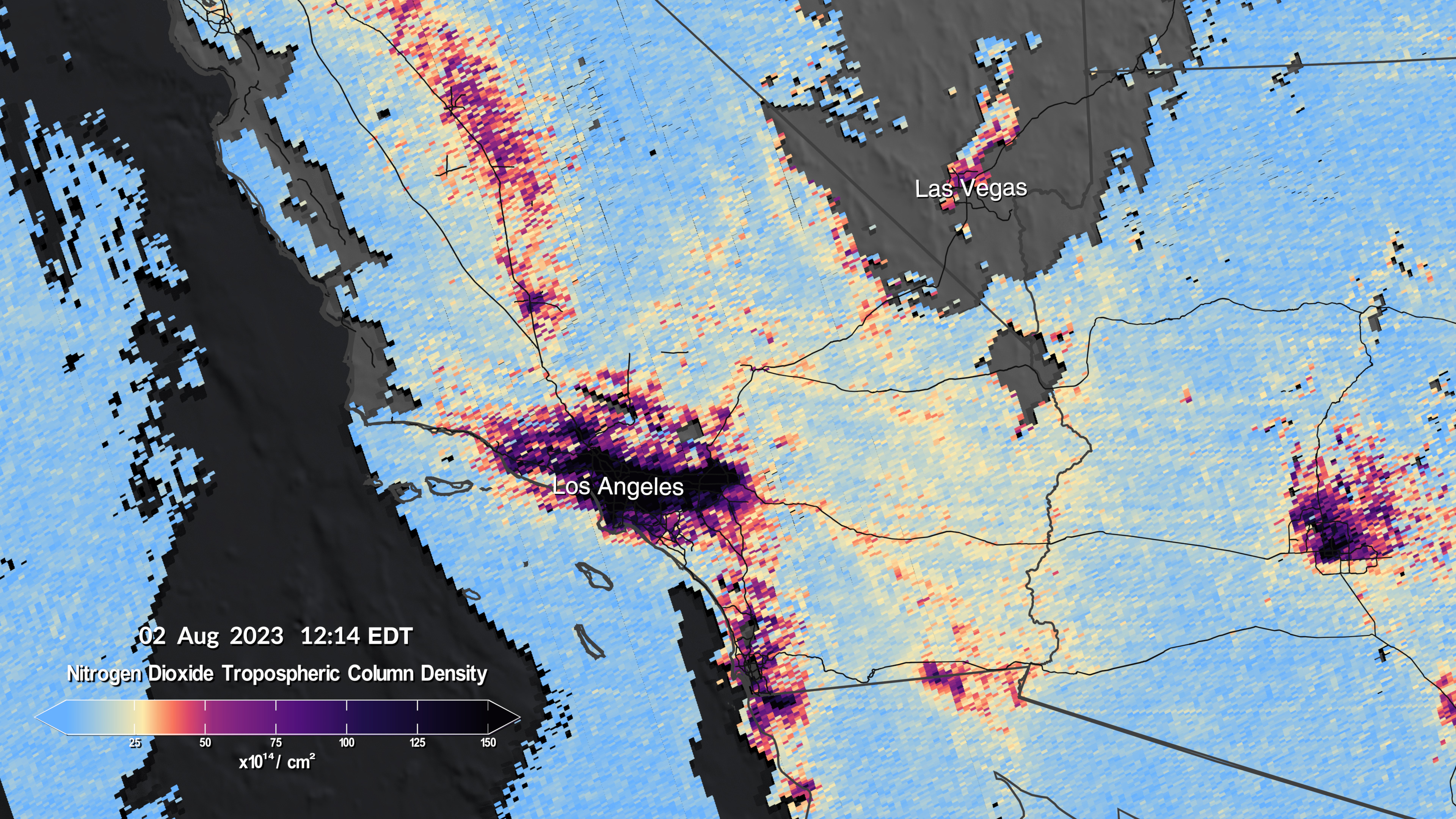
 This pair of images shows nitrogen dioxide levels over Southern California at 12:14 and 4:24 p.m. on August 2, as measured by TEMPO.Credits: Kel Elkins, Trent Schindler, and Cindy Starr/NASA’s Scientific Visualization Studio
The visualizations show six scans made between 11:12 a.m. and 5:27 p.m. EDT on Aug. 2. Closeup views focus on the southwestern U.S. from Los Angeles to Las Vegas; from central and eastern Texas to New Orleans; and the Interstate 95 corridor between New York and Washington. The data were gathered during TEMPO’s “first light” period from July 31 to Aug. 2, when mission controllers opened the spectrometer to look at the Sun and Earth and start a variety of tests and solar calibrations.
“TEMPO is beginning to measure hourly daytime air pollution over greater North America,” said Kelly Chance, SAO senior physicist and TEMPO principal investigator. “It measures ozone, nitrogen dioxide, formaldehyde, aerosols, water vapor, and several trace gases. There are already almost 50 science studies being planned that are based around this new way to collect data.”
The TEMPO instrument was built by Ball Aerospace and integrated with the Maxar-built Intelsat 40e. Since launch, teams from NASA, Ball Aerospace, and SAO have been checking and calibrating the satellite’s systems and components. The instrument will begin full operations in October, collecting hourly daytime scans, the first instrument to observe pollution over North America in this way.
“We are excited to see the initial data from the TEMPO instrument and that the performance is as good as we could have imagined now that it is operating in space,” said Kevin Daugherty, TEMPO project manager at NASA’s Langley Research Center in Hampton, Virginia. “We look forward to completing commissioning of the instrument and then starting science research.”
TEMPO is part of NASA’s Earth Venture Instrument program, which includes small, targeted science investigations designed to complement NASA’s larger research missions. The instrument also forms part of a virtual constellation of air pollution monitors for the Northern Hemisphere which also includes South Korea’s Geostationary Environment Monitoring Spectrometer and ESA’s (European Space Agency) Sentinel-4 satellite.
For more information on NASA’s Earth science research, visit:
-end-
Karen Fox/Katherine Rohloff
Headquarters, Washington
202-358-1100
karen.fox@nasa.gov / katherine.a.rohloff@nasa.gov
Charles Hatfield
Langley Research Center, Hampton, Virginia
757-864-2509
charles.g.hatfield@nasa.gov