


A Georgia-based company called Cybercorps LLC plans to offer real-time agricultural data for farmers, resource managers, first responders, and other interested user groups with the help of a patented NASA technology. Cybercorps has signed a license agreement with NASA for the Compact Thermal Imager (CTI), a technology developed at NASA’s Goddard Space Flight Center in Greenbelt, Maryland.
The technology, conceived at Goddard by CTI Principal Investigator Murzy Jhabvala, is small enough to fit on a cube satellite, or CubeSat, a type of miniaturized satellite whose size is measured in units of 10 square centimeters that plays a growing role at NASA for science missions and technology demonstrations. Though tiny in size, CTI can provide high-resolution information about crop health and soil conditions by measuring surface temperature. After collecting more than 15 million images of Earth during a successful demonstration on the International Space Station in 2019, the instrument is now ready for commercial use.
“Technologies like CTI were developed for research purposes, but they often have additional applications outside of pure science,” said Eric McGill, a senior technology manager with the Strategic Partnerships Office at Goddard. “In this case, infrared imaging can play an important role in monitoring crop health and helping members of the agricultural community yield better harvests.”
The CubeSat that will carry CTI will capture thermal images while pointed at Earth’s surface. Farmers and other interested customers can subscribe to Cybercorps’ service to access the thermal imaging data, which can be used to evaluate the health of agricultural and aquatic ecosystems. In combination with more traditional techniques, this bundle of information could help farmers optimize fertilizer treatments and watering schedules.
“This instrument is very versatile,” said Compton Tucker, a senior Earth scientist at Goddard and co-investigator for CTI. “As a new technology, it has tremendous usage potential in biomass burning and crop surface temperature.”
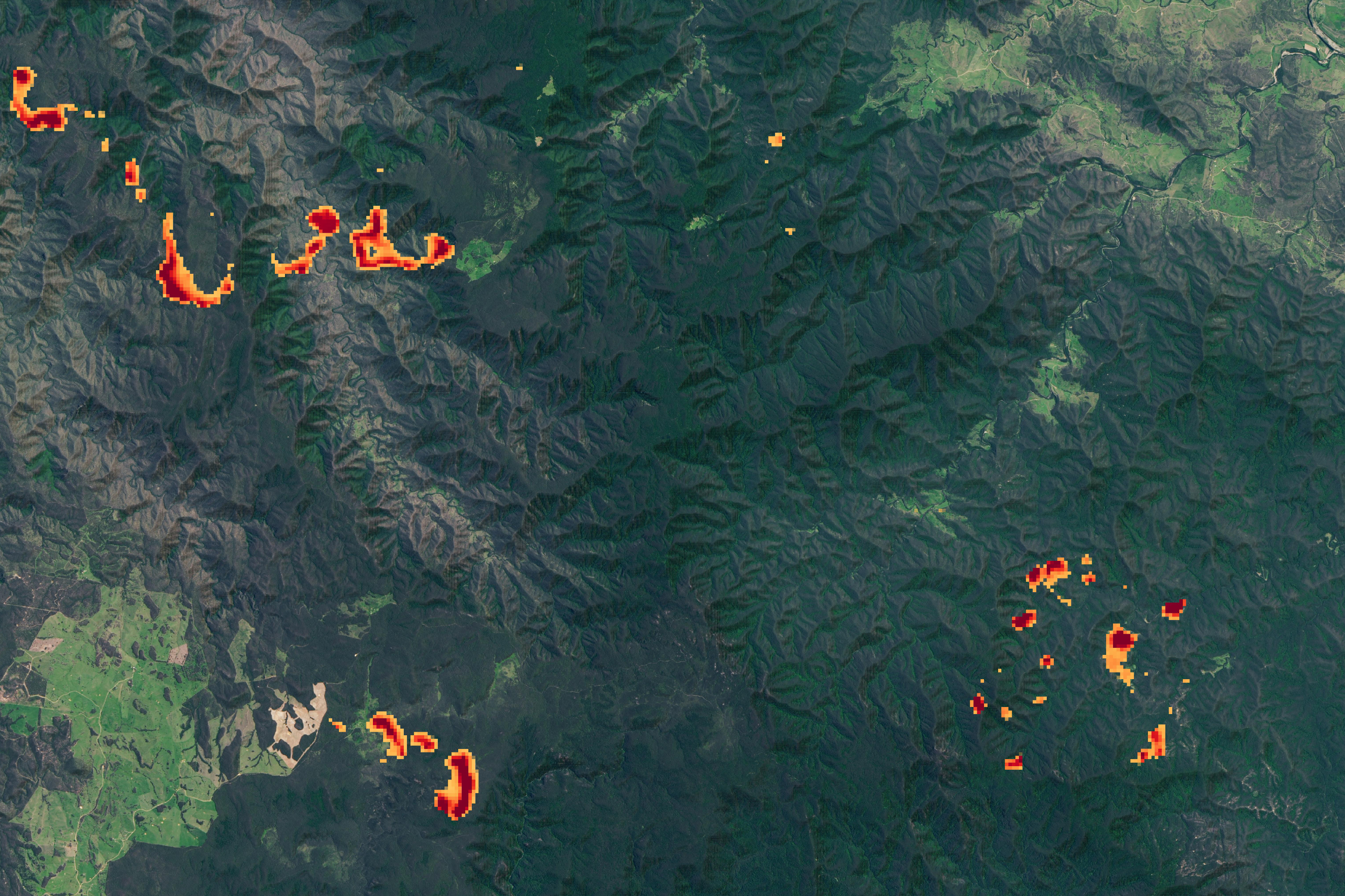
In addition to CTI’s agricultural applications, Tucker said the technology can help detect wildfire activity by distinguishing between high combustion areas and less hot, smoldering sections of land. For firefighters on the ground, this data could guide them to actively burning areas. CTI provides precise spatial resolution of around 262 feet (80 meters) per pixel, improving on older instruments that provided less detailed resolution at 3,280 feet (1 kilometer) per pixel.
Cybercorps will take advantage of CTI’s ability to measure surface temperature. Plants need sufficient water to complete photosynthesis, and surface temperature provides a key data point in determining how much irrigation is needed to prevent crop death.
“Our company’s core components are research, education, and commercialization, so the space camera subscription project spans all three of our objectives,” said Kevin Howard, chairman and founder of Cybercorps.
In addition to commercializing its service, Cybercorps plans to include students in the development of this project. The company will participate in the NASA International Space Apps Challenge, which takes place Oct. 2-4.
“This is our first license agreement with NASA, and we’re really excited about the opportunity to collaborate with Goddard on this,” Howard said.
CTI was installed on the space station in 2019 as part of the Robotic Refueling Mission 3, with the goal of qualifying Strained Layer Superlattice (SLS), an advanced detector technology. SLS is an improved version of the detector technology that is part of the thermal infrared sensor on Landsat 8 and the upcoming Landsat 9. CTI instrument development was supported and funded by NASA’s Earth Science Technology Office (ESTO) under the Sustainable Land Imaging Technology program.
To learn more about NASA’s Technology Transfer program and space technologies available for license, please visit:
Banner Image: Wheat fields close to harvest sit under a cloudy sky at the Marc Arnusch Farms, in Keenesburg, Colorado, on June 19, 2020. Credit: USDA Photo by Lance Cheung
By Amy Klarup
NASA’s Goddard Space Flight Center, Greenbelt, Md.