


Data Products
| Products | Data Frequency | Algorithm |
|---|---|---|
| Top-of-Atmosphere Reflectance Brightness Temperature Solar Zenith/Azimuth Angles Satellite View Zenith/Azimuth Angles | 10-minute 10-minute Fixed | Wang et al. (2020) Yamamoto et al. (2020) |
| Cloud Mask Aerosol Optical Depth Surface Reflectance Surface BRDF | 10-minute 10-minute 10-minute Daily | Lyapustin et al. (2018) Wang et al. (2022) |
| Land Surface Temperature Surface Solar Radiation | 10-minute/Hourly 10-minute/Hourly | Yu et al. (2010) Duffy et al. (2021) Liang et al. (2006) Li et al. (2023) |
Level 1G Products: Top-of-Atmosphere (TOA) Reflectance and Brightness Temperature
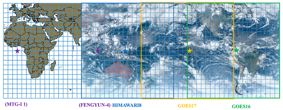
The GeoNEX TOA products provided radiometrically calibrated BRFs (reflective bands), brightness temperatures (emissive bands), and pixelwise Sun angles at every time step, all of which were correctly registered to the common tiled grid in the geographic projection. The true-color image shown above is created based on TOA BRFs from Himawari 8 AHI, GOES 17 ABI, and GOES 16 ABI. The pseudo “green band” of the ABI instrument is generated from the red, the blue, and the near-infrared bands with linear weights of 0.483, 0.457, and 0.060, respectively. The thin gray lines indicate coastlines and the boundaries of the GeoNEX tiles. We expect to derive similar MTG/FCI L1G products to fill up the missing coverage over Europe and Africa in late 2023 or early 2024.
Level 2 Products: Surface BRDF and Reflectance
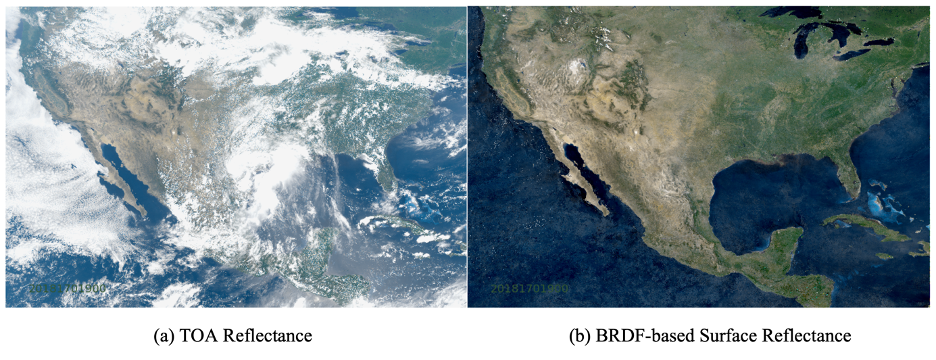
We adopt the Multi-Angle Implementation of Atmospheric Correction (MAIAC) algorithm to exploit the high temporal resolutions of the latest geostationary satellite sensors (e.g., GOES-16/17 ABI, Himawari 8/9 AHI, and Geo-KOMPSAT 2A/AMI) in deriving surface reflectance (SR), atmospheric aerosol optical depth (AOD), and the corresponding BRDF model parameters. The algorithm is developed based on Green’s functions and BRDF-specific radiative transfer model as well as its framework for time-series processing. It dynamically maintains a set of variables that “memorize” the surface properties at each grid cell from the preceding time steps and use them for the up-coming processing. Therefore, we can even combine the prior knowledge of surface BRDF with cloudy-sky observations to predict the most likely “clear-sky” surface reflectance at given illumination-view geometries.
Level 3 Products: Surface Downward Solar Radiation
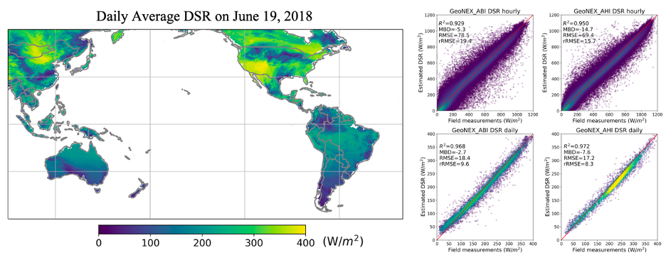
We employ a well-established physical-based lookup table (LUT) approach to create a data product of Downward Shortwave Radiation (DSR) and Photosynthetic Active Radiation (PAR) over both AHI and ABI coverage at an hourly temporal step with a 1 km spatial resolution. The DSR and PAR data are validated over in-situ measurement stations. The validation showed that the new GeoNEX DSR and PAR products have accuracy higher than other existing products, with root mean square error (RMSE) of hourly DSR achieving 74.3Wm−2 (18.0%), daily DSR estimation achieving 18.0 W m−2 (9.2 %), hourly PAR achieving 34.9 W m−2 (19.6 %), and daily PAR achieving 9.5 W m−2 (10.5 %).
Data Access
Level 1 data and gridded data products are available at the NASA Earth Exchange data portal, hosted by NASA’s Advanced Supercomputing. NASA-supported investigations under the ROSES 2019 “Earth Science Research from Operational Geostationary Satellite Systems” program element will, in addition, have access to tools, additional data, computing and support. For questions and/or issues with the data products, email support@nas.nasa.gov and include “GeoNEX” in the subject line.
GeoNEX users with NAS accounts can find the all data products on the Lustre file systems here /nex/datapool/geonex/.
Supporting datasets for any research and development of data products, such as MODIS products, Landsat, VIIRS, or any other relevant datasets, can also be found on the NAS file systems at /nex/datapool/
Global Grid System
All GeoNEX products are in a geographic coordinate system (i.e., latitude/longitude grid) with a spatial resolution of 0.01 x 0.01 degrees (visible/near infrared bands) or 0.02 x 0.02 degrees (shortwave/thermal Infrared bands).
The geospatial domain of the GOES ABI is the region from 60°N, 138°W to 60°S, 18°W. The domain of the Himawari AHI is the region from 60°N, 78°E to 60°S, 198°E. The regions are divided into 20×20 rectangular tiles, numbered from 0 to 19 in the vertical dimension. Each tile contains 600×600 (visible/near infrared bands) or 300×300 (shortwave/thermal infrared bands) pixels, representing 6° by 6°.
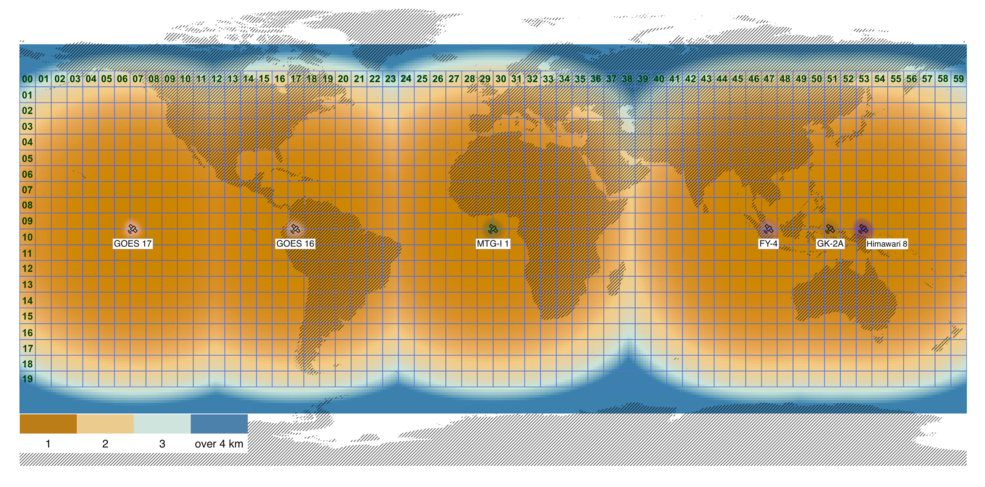
The temporal resolution of the products is every 15 minutes (for the full domain) or every 5 minutes (for the conterminous U.S.)
Example for 0.01×0.01 (1km) grid:
# Basic parameters
lat_0 = 60
lon_0 = -180
res_x = 0.01 # 0.02 for the 2km grid
res_y = 0.01 # 0.02 for the 2km grid
tile_xdim = 600 # 300 for the 2km grid
tile_ydim = 600 # 300 for the 2km grid
# Input information
hid = 14 # 0 – 59
vid = 5 # 0 – 19
x = 0 # column/sample, 0-(tile_xdim-1)
y = 0 # row/line, 0-(tile_ydim-1)
# Output formula
lat_ulcnr = lat_0 – (vid*tile_ydim + y)*res_y # upper-left corner latitude
lon_ulcnr = lon_0 + (hid*tile_xdim + x)*res_y # upper-left corner longitude
lat_cntr = lat_ulcnr – 0.5*res_y # center latitude
lon_cntr = lon_ulcnr + 0.5*res_x # center longitude
File Format
The data are organized by tile and date. The naming convention of the files is:
<Satellite/Sensor Code><ProductID>_<YYYYMMDD>_<HHMM>_GLBG_h<hid>v<vid>_<version>.hdf
<Satellite/Sensor Code>: HM08_AHI for Himawari 8 AHI, and GO16_ABI or GO17_ABI for GOES
<Product ID>: A two-digit number assigned to each GeoNEX product. Currently, only the Product ID of “05” is available, indicating “Top-of-Atmosphere Reflectance”
<YYYYMMDD>: Year-Month-Day, e.g., 20180501
<HHMM>: Hour-Minute (UTC time), e.g., 2030
<hid>, <vid>: Horizontal or Vertical Tile ID (0-19)
<version>: Product version code. It is currently “02”
Disclaimer
The data are considered provisional and subject to change. The data are provided as is without any warranty of any kind, either express or implied, arising by law or otherwise, including but not limited to warranties of completeness, non-infringement, accuracy, merchantability, or fitness for a particular purpose. The user assumes all risk associated with the use of, or inability to use, the data.