![Request for Information – Potential [Placeholder for Prize]](https://assets.science.nasa.gov/dynamicimage/assets/science/missions/a-step/FFR_Earth_Background_20251120%20.png?w=1024)


The JPL-led international team used the island as a stand-in for Venus to test radar technologies that will help uncover the planet’s ground truth.
With its crushing atmospheric pressure, clouds of sulfuric acid, and searing surface temperature, Venus is an especially challenging place to study. But scientists know that observing its surface can provide key insights into the habitability and evolution of rocky planets like our own. So to get a global perspective of Venus while staying well above its hellish atmosphere, NASA’s VERITAS (Venus Emissivity, Radio science, InSAR, Topography, And Spectroscopy) mission is scheduled to launch within a decade to survey the planet’s surface from orbit, uncovering clues about the nature of its interior.
To lay the groundwork for the mission, members of the international VERITAS science team traveled to Iceland for a two-week campaign in August to use the volcanic island as a Venus stand-in, or analog. Locations on our planet often are used as analogs for other planets, especially to help prepare technologies and techniques intended for more uninviting environments.
“Iceland is a volcanic country that sits atop a hot plume. Venus is a volcanic planet with plentiful geological evidence for active plumes,” said Suzanne Smrekar, senior research scientist at NASA’s Jet Propulsion Laboratory in Southern California and the VERITAS principal investigator. “Its geological similarities make Iceland an excellent place to study Venus on Earth, helping the science team prepare for Venus.”
The VERITAS mission will rely on a state-of-the-art synthetic aperture radar to create 3D global maps and a near-infrared spectrometer to distinguish between the major rock types on Venus’ surface. But to better understand what the spacecraft’s radar will “see” on the planet, the VERITAS science team would need to compare radar observations of Iceland’s terrain from the air with measurements taken on the ground.
From Air to Ground
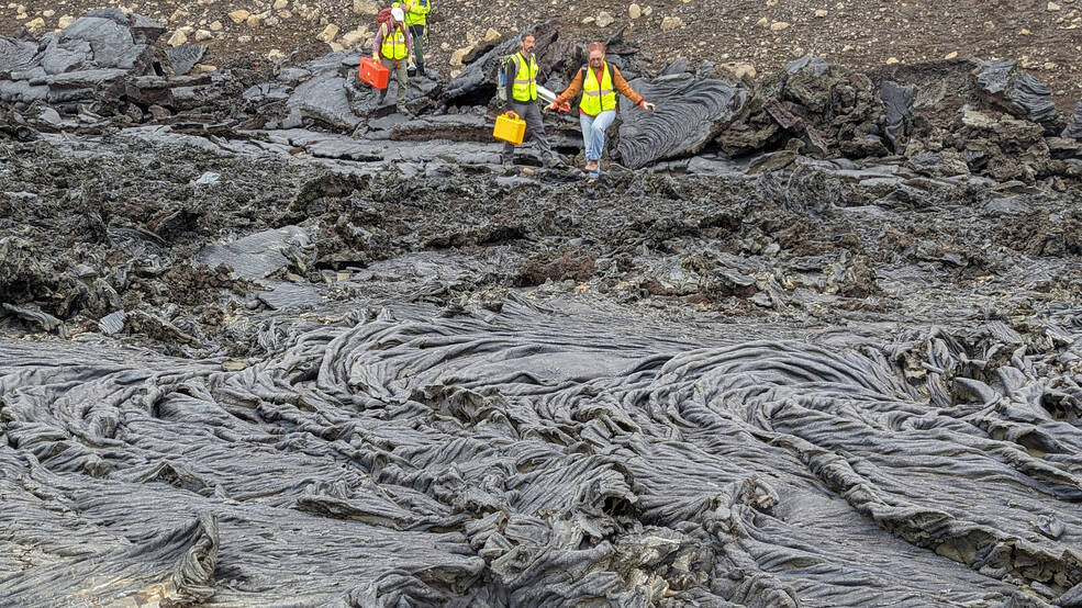
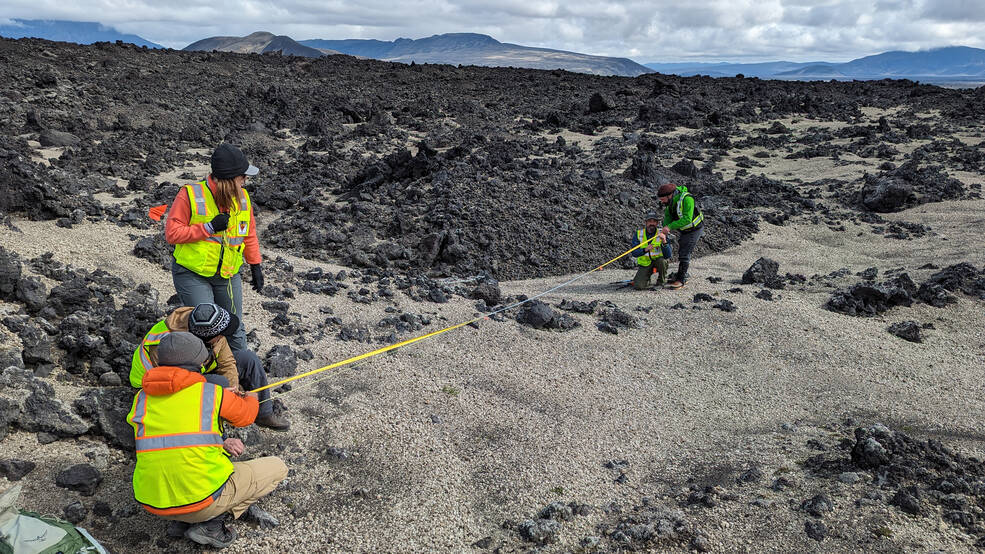
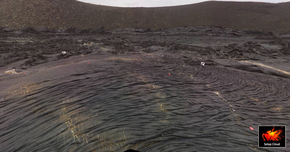
For the first half of the campaign, the VERITAS science team studied the Askja volcanic deposits and the Holuhraun lava field in the Icelandic Highlands, an active region featuring young rock and recent lava flows. For the second half, they traveled to the volcanically active Fagradalsfjall region on the Reykjanes Peninsula of southwestern Iceland. The barren and rocky landscapes of both resemble Venus’ surface, which is thought to be rejuvenated by active volcanism.
Nineteen scientists from the U.S., Germany, Italy, and Iceland camped and worked long hours to study the surface roughness and other properties of rocks in those regions, collecting lab samples as well. Meanwhile, flights led by the German Aerospace Center (Deutsches Zentrum für Luft- und Raumfahrt, or DLR) collected radar data from above.
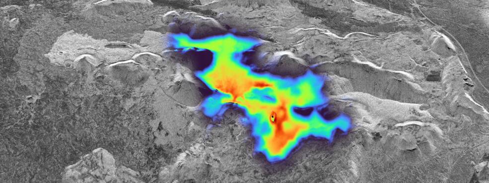
“The JPL-led science team was working on the ground while our DLR partners flew overhead to gather aerial radar images of the locations we were studying,” said Daniel Nunes, VERITAS deputy project scientist at JPL and Iceland campaign planning lead. “The radar brightness of the surface relates to the properties of that surface, including texture, roughness, and water content. We collected information in the field to ground-truth the radar data that we will use that to inform the science that VERITAS will do at Venus.”
Flying aboard DLR’s Dornier 228-212 aircraft about 20,000 feet (6,000 meters) above the ground, the synthetic aperture radar collected S-band (radio waves with a wavelength of about 12 centimeters, or 4.7 inches) and X-band (about 3 centimeters, or 1.2 inches) data. The shorter wavelength of X-band data – the radio frequency VERITAS will employ – enables the use of a more compact antenna than S-band, which was used by NASA’s Magellan mission to map nearly the entire surface of Venus in the early 1990s.
By observing the surface in both bands in Iceland, the science team will refine computer algorithms that will help VERITAS identify surface changes on Venus that have occurred since Magellan’s mission. Detecting changes over the last 40 years will allow them to identify key regions of geologic activity (such as active volcanoes) on Venus.
A key goal for the campaign was to also create a sample library of as many volcanic surface textures in Iceland as possible to better understand Venus’ range of eruption styles. A DLR field team also collected compositional information with a camera that emulates the Venus Emissivity Mapper (VEM) instrument the German Aerospace Center is building for VERITAS. This data will support the spectral library being created at the Planetary Spectroscopy Laboratory in Berlin.
“The different surface characteristics and features seen on Venus relate to volcanic processes, which relate back to the interior of Venus,” said Smrekar. “This data is going to be valuable to VERITAS to help us better understand Venus. It will also help the European Space Agency’s EnVision mission, which will study Venus’ surface with S-band radar, and the community at large that wants to understand radar observations of volcanic planetary surfaces.”
But the value of the two-week Iceland campaign went beyond science, providing a team-building opportunity that will resonate for years to come, said Nunes. “It was a great dynamic,” he added. “We pushed hard and helped each other out. From borrowing gear to driving to the study sites and buying supplies, everyone hustled to make it happen.”
More About the Mission
VERITAS and NASA’s Deep Atmosphere Venus Investigation of Noble gases, Chemistry, and Imaging (DAVINCI) mission were selected in 2021 under NASA’s Discovery Program as the agency’s next missions to Venus. VERITAS partners include Lockheed Martin Space, the Italian Space Agency, the DLR, and Centre National d’Études Spatiales in France. The Discovery Program is managed by the Planetary Missions Program Office at NASA’s Marshall Space Flight Center in Huntsville, Alabama, for the Planetary Science Division of NASA’s Science Mission Directorate in Washington.
Media Contacts
Ian J. O’Neill
Jet Propulsion Laboratory, Pasadena, Calif.
818-354-2649
ian.j.oneill@jpl.nasa.gov
Karen Fox / Alana Johnson
NASA Headquarters, Washington
301-286-6284 / 202-358-1501
karen.c.fox@nasa.gov / alana.r.johnson@nasa.gov
2023-133