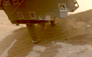
The rover has arrived at an area that may show evidence liquid water flowed on this part of Mars for much longer than previously thought.
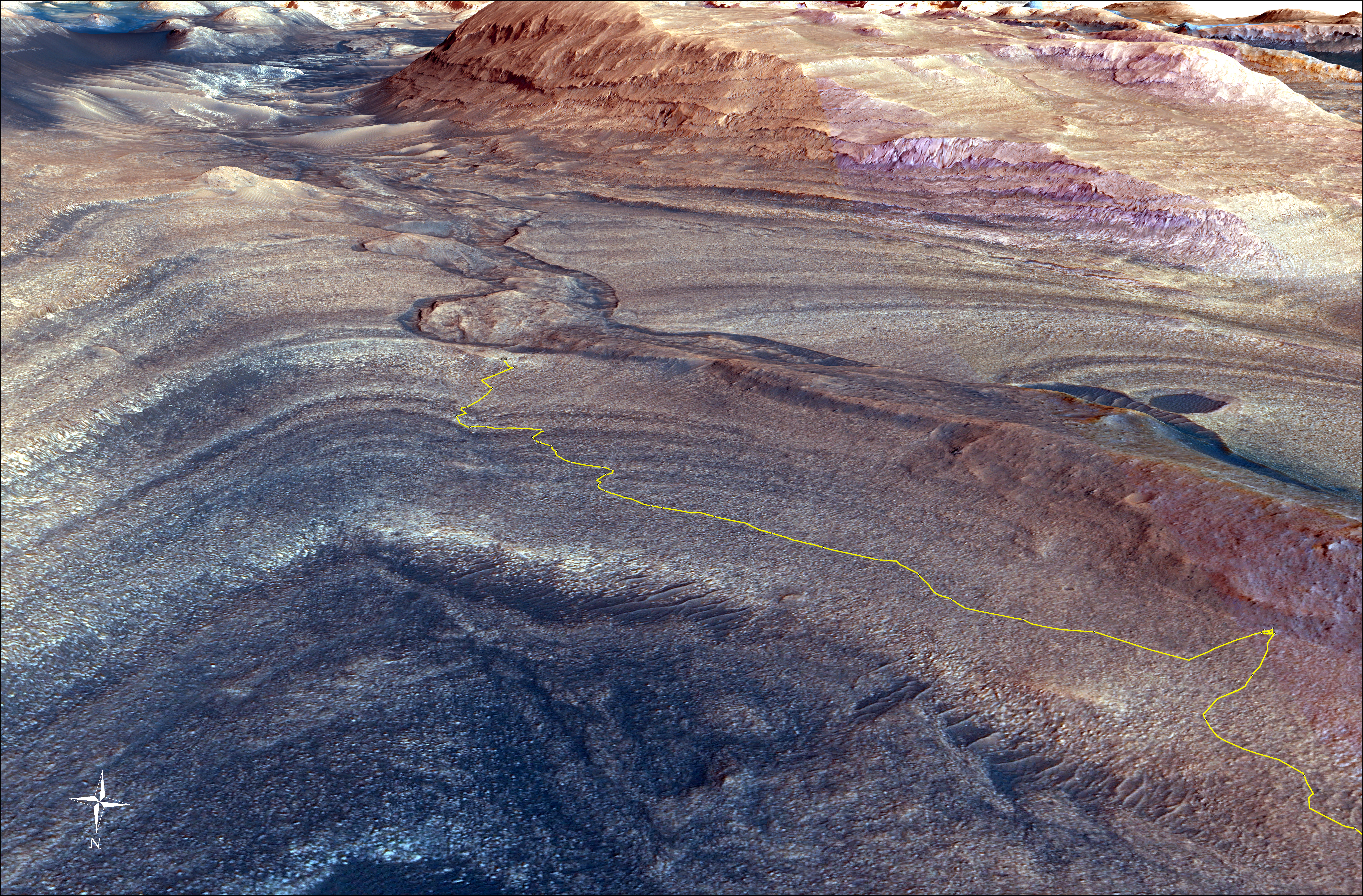
NASA’s Curiosity rover has begun exploring a new region of Mars, one that could reveal more about when liquid water disappeared once and for all from the Red Planet’s surface. Billions of years ago, Mars was much wetter and probably warmer than it is today. Curiosity is getting a new look into that more Earth-like past as it drives along and eventually crosses the Gediz Vallis channel, a winding, snake-like feature that – from space, at least – appears to have been carved by an ancient river.
That possibility has scientists intrigued. The rover team is searching for evidence that would confirm how the channel was carved into the underlying bedrock. The formation’s sides are steep enough that the team doesn’t think the channel was made by wind. However, debris flows (rapid, wet landslides) or a river carrying rocks and sediment could have had enough energy to chisel into the bedrock. After the channel formed, it was filled with boulders and other debris. Scientists are also eager to learn whether this material was transported by debris flows or dry avalanches.
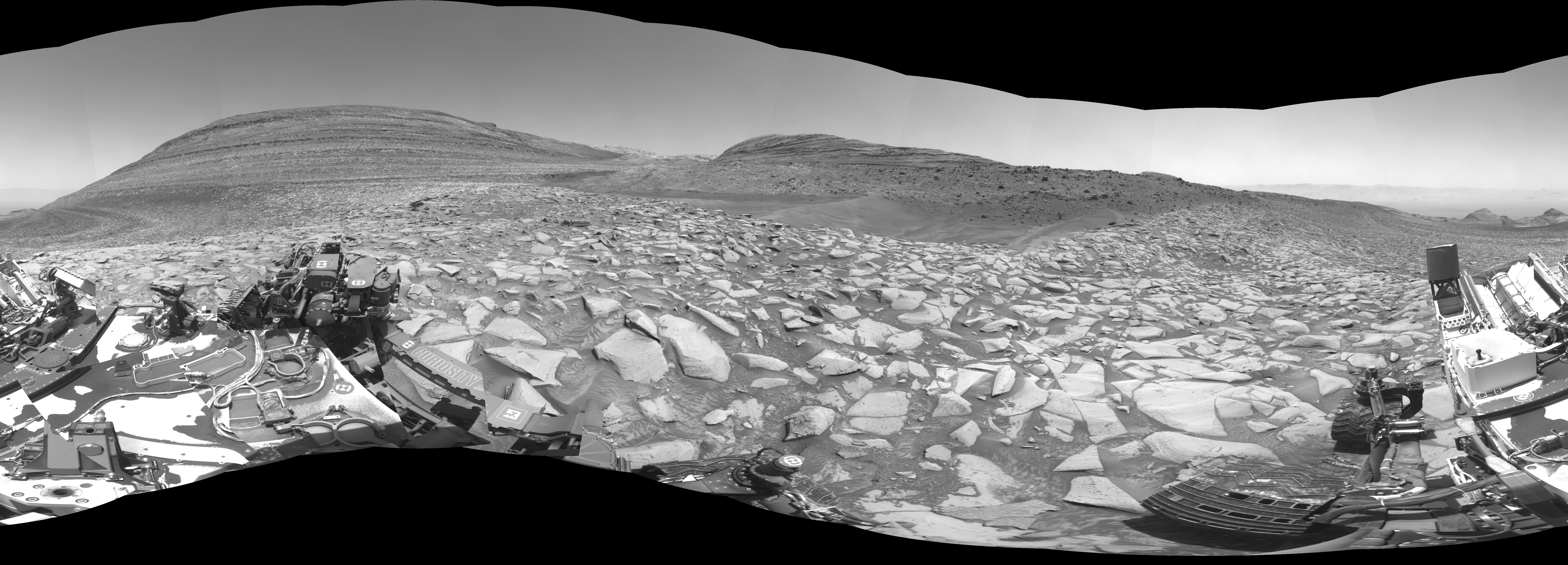
Credit: NASA/JPL-Caltech
Since 2014, Curiosity has been ascending the foothills of Mount Sharp, which stands 3 miles (5 kilometers) above the floor of Gale Crater. The layers in this lower part of the mountain formed over millions of years amid a changing Martian climate, providing scientists with a way to study how the presence of both water and the chemical ingredients required for life changed over time.
For example, a lower part of those foothills included a layer rich in clay minerals where a lot of water once interacted with rock. Now the rover is exploring a layer enriched with sulfates – salty minerals that often form as water evaporates.
Revising Mount Sharp’s Timeline
It will take months to fully explore the channel, and what scientists learn could revise the timeline for the mountain’s formation.
Once the sedimentary layers of lower Mount Sharp had been deposited by wind and water, erosion whittled them down to expose the layers visible today. Only after these lengthy processes – as well as intensely dry periods during which the surface of Mount Sharp was a sandy desert – could the Gediz Vallis channel have been carved.
Scientists think the boulders and other debris that subsequently filled the channel came from high up on the mountain, where Curiosity will never go, giving the team a glimpse of what kinds of material may be up there.
“If the channel or the debris pile were formed by liquid water, that’s really interesting. It would mean that fairly late in the story of Mount Sharp – after a long dry period – water came back, and in a big way,” said Curiosity’s project scientist, Ashwin Vasavada of NASA’s Jet Propulsion Laboratory in Southern California.
That explanation would be consistent with one of the most surprising discoveries Curiosity has made while driving up Mount Sharp: Water seems to have come and gone in phases, rather than gradually disappearing as the planet grew drier. These cycles can be seen in evidence of mud cracks; shallow, salty lakes; and, directly below the channel, cataclysmic debris flows that piled up to create the sprawling Gediz Vallis ridge.
Last year, Curiosity made a challenging ascent to study the ridge, which drapes across the slopes of Mount Sharp and seems to grow out of the end of the channel, suggesting both are part of one geologic system.
Viewing the Channel Up Close
Curiosity documented the channel with a 360-degree black-and-white panorama from the rover’s left navigation camera. Taken on Feb. 3 (the 4,086th Martian day, or sol, of the mission), the image shows the dark sand that fills one side of the channel and a debris pile rising just behind the sand. In the opposite direction is the steep slope that Curiosity climbed to reach this area.
The rover takes these kinds of panoramas with its navigation cameras at the end of each drive. Now the science team is relying on the navcams even more while engineers try to resolve an issue that is limiting the use of one imager belonging to the color Mast Camera, or Mastcam.
More About the Mission
Curiosity was built by JPL, which is managed by Caltech in Pasadena, California. JPL leads the mission on behalf of NASA’s Science Mission Directorate in Washington.
For more about Curiosity, visit:
News Media Contacts
Andrew Good
Jet Propulsion Laboratory, Pasadena, Calif.
818-393-2433
andrew.c.good@jpl.nasa.gov
Karen Fox / Alana Johnson
NASA Headquarters, Washington
301-286-6284 / 202-358-1501
karen.c.fox@nasa.gov / alana.r.johnson@nasa.gov
2024-034