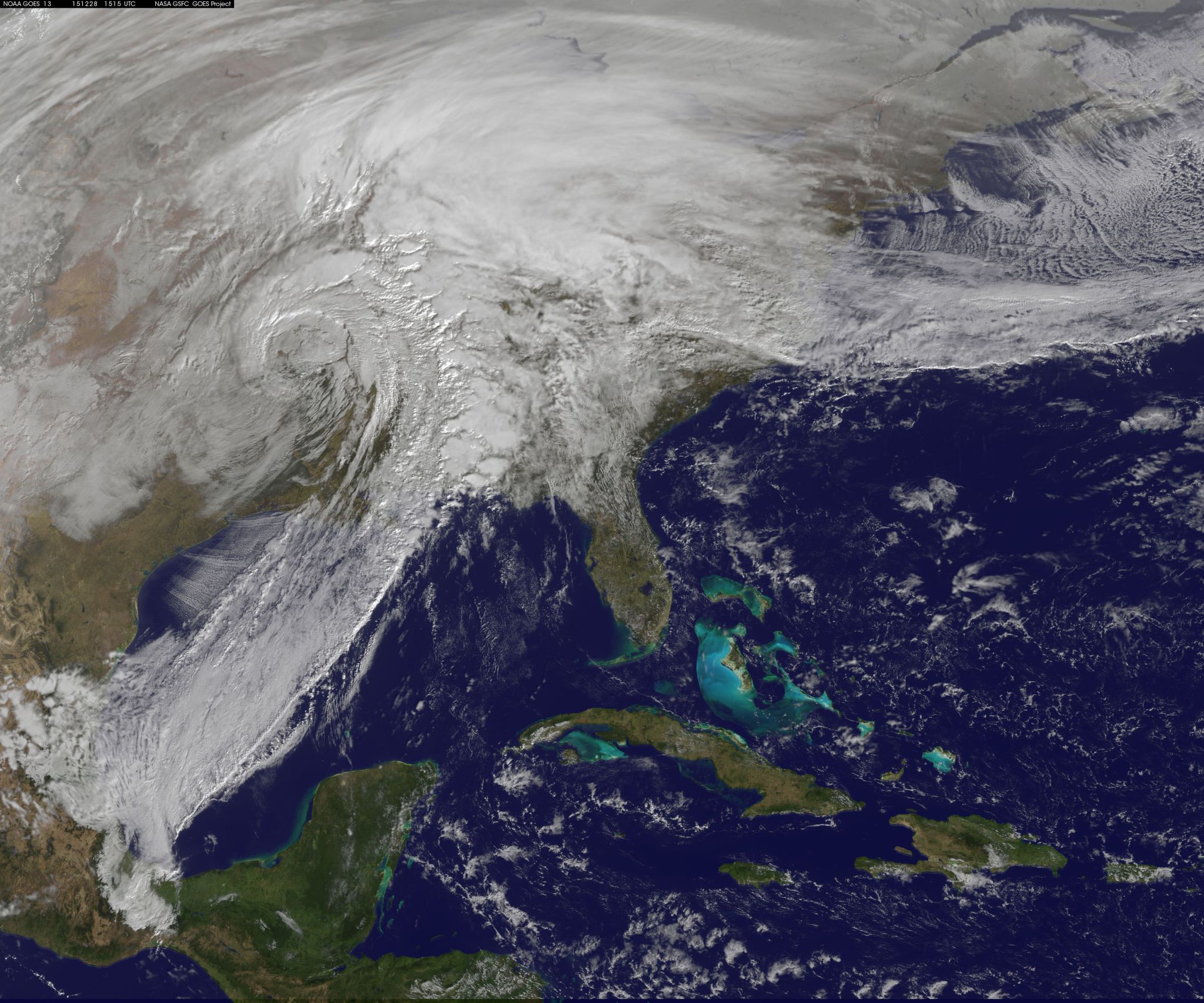
An animation of satellite imagery over the course of two days shows a massive low pressure system that generated severe weather in the southwestern and central U.S. bringing snow, heavy rainfall, flooding and tornadoes. The video, created by the NASA/NOAA GOES Project at NASA’s Goddard Space Flight Center in Greenbelt, Maryland, combined visible and infrared imagery from NOAA’s GOES-East satellite.
Credits: NASA/NOAA GOES Project
Download this video
The 30-second animation shows the movement of the massive storm system from Dec. 26 to early Dec. 28, 2015.
In the animation, during Dec. 26, clouds can be seen containing the line of severe thunderstorms that generated multiple tornadoes in the vicinity of Dallas. The National Weather Service reported an EF-4 tornado (175 mph winds) hit Garland, Texas, at about 6:45 p.m. (0045 UTC, Dec. 27 on the animation).
The storm system also generated heavy snow and flooding in parts of Texas, Oklahoma and New Mexico. Heavy rain fell in Missouri, Arkansas, Mississippi, Alabama and the Florida Panhandle.
The National Weather Service Forecast Office in Little Rock, Arkansas, noted that rain in northern and western Arkansas spread across the remainder of the state through the overnight hours of Dec. 27 and early on Dec. 28. By 12 a.m. CST on Dec. 28, rainfall of more than 6 inches had fallen in portions of the Ozark and Ouachita mountains (toward the Oklahoma border).
GOES-East also captured a still image on Dec. 28 at 9:45 a.m. EST (1445 UTC ) that showed the center of the low pressure area over Oklahoma. South of the low pressure center clouds associated with a cold front extending southward over the Gulf of Mexico, and severe storms are possible ahead of the front according to the National Weather Service. A stationary front extends east from the low’s center across the Tennessee Valley and the Carolinas bringing the potential for flash flooding. North and northeast of the low pressure area snow and freezing rains are expected through the heartland into the Great Lakes region and into New England.
The National Weather Service Weather Prediction Center (NWS NPC) in College Park, Maryland, said, “A major storm system will continue to bring a plethora of impacts including heavy snowfall, ice, heavy rainfall, flooding and severe weather today and tonight.”
On Dec. 28, flood and flash flood warnings, watches and advisories were in effect from northeast Texas, across the mid-Mississippi Valley into the Tennessee and Ohio River Valleys. In addition, Winter Storm Warnings and advisories extended from north-central Texas northeastward through the Midwest and the Great Lakes. Winter weather advisories and winter storm watches were issued for much of New England.
NWS NPC said, “The low pressure system will move toward the Great Lakes region on Tuesday shifting the winter storm threat into Upstate New York and New England.” For updated forecasts visit: www.weather.gov.
Rob Gutro
NASA’s Goddard Space Flight Center, Greenbelt, Md.

