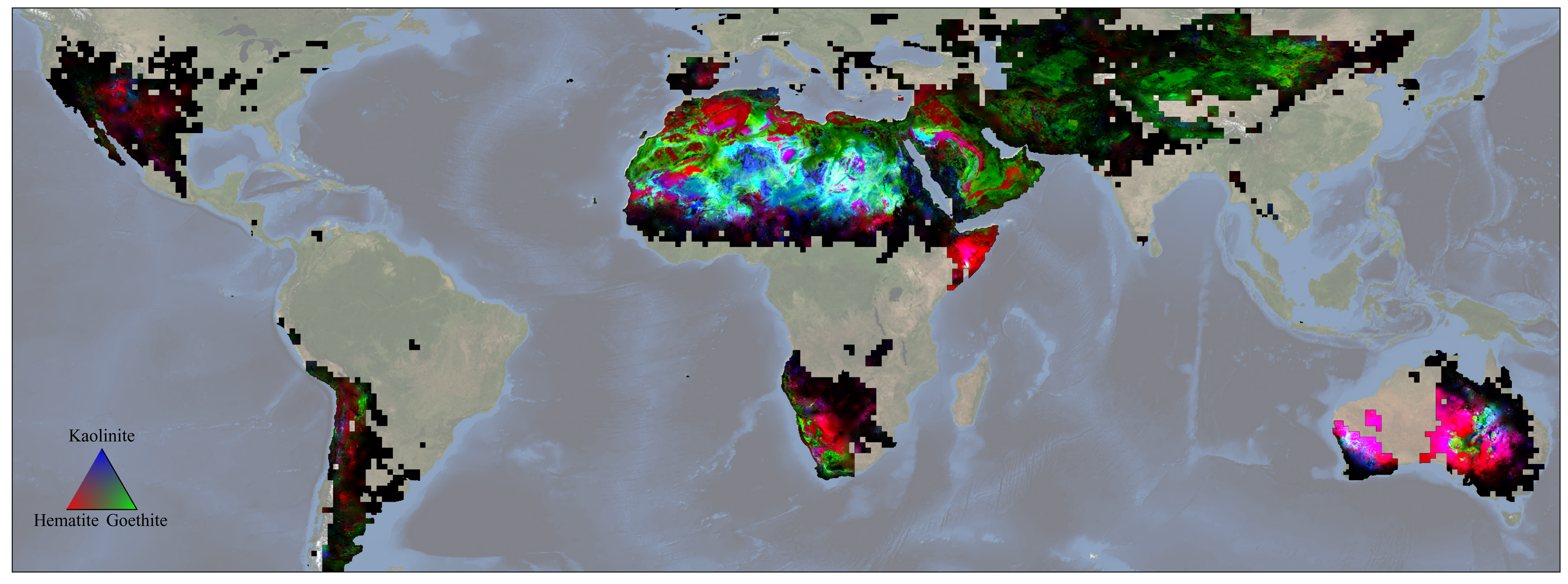
EMIT delivers first-of-a-kind maps of minerals in Earth’s dust-source areas, enabling scientists to model the fine particles’ role in climate change and more.
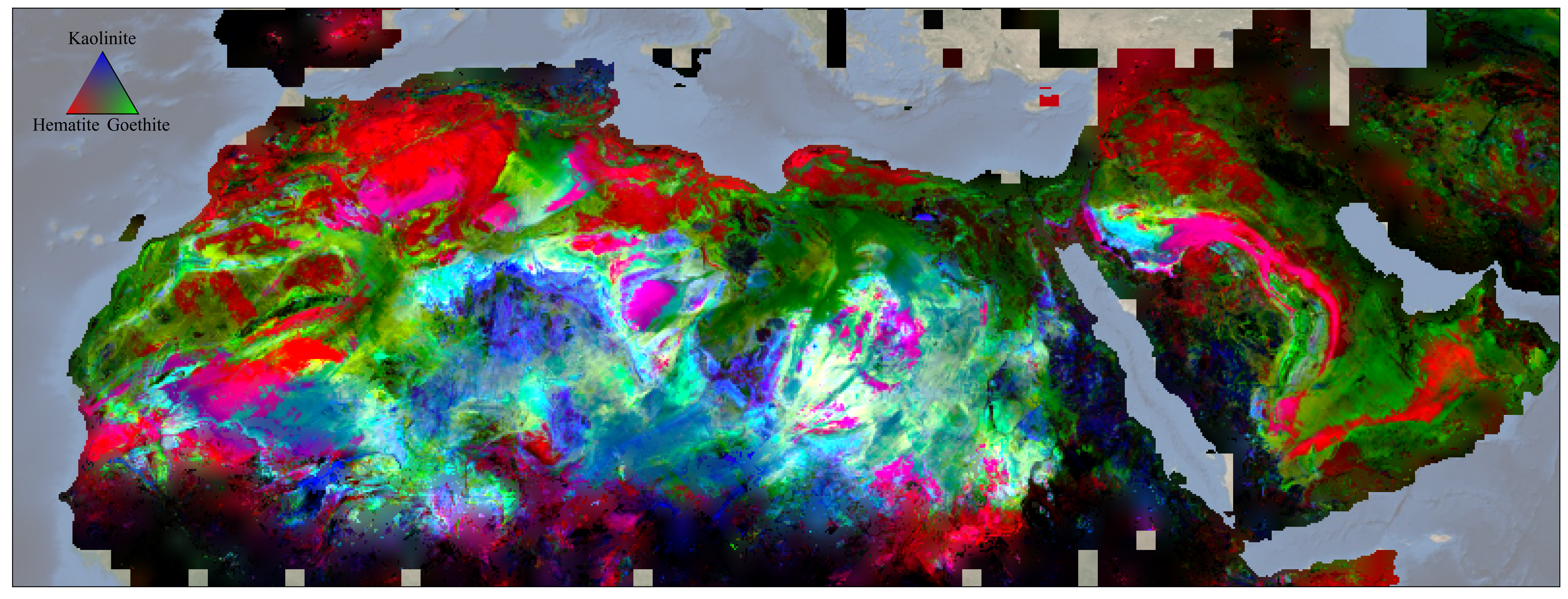
NASA’s EMIT mission has created the first comprehensive maps of the world’s mineral dust-source regions, providing precise locations of 10 key minerals based on how they reflect and absorb light. When winds loft these substances into the air, they either cool or warm the atmosphere and Earth’s surface, depending on their composition. Understanding their abundance around the globe will help researchers predict future climate impacts.
Launched to the International Space Station in 2022, EMIT – short for Earth Surface Mineral Dust Source Investigation – is an imaging spectrometer developed by NASA’s Jet Propulsion Laboratory in Southern California. The mission fills a crucial need among climate scientists for more detailed information on surface mineral composition.
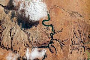
Surveying Earth’s surface from about 250 miles (410 kilometers) above, EMIT scans broad areas that would be impossible for a geologist on the ground or instruments carried by aircraft to survey, yet it does this while achieving effectively the same level of detail.
To date, the mission has captured more than 55,000 “scenes” – 50-by-50-mile (80-by-80-kilometer) images of the surface – in its study area, which includes arid regions within a 6,900-mile-wide (11,000-kilometer-wide) belt around Earth’s mid-section. Taken together, the scenes comprise billions of measurements – more than enough to create detailed maps of surface composition.
The mission has also demonstrated a range of additional capabilities in its 17 months in orbit, including detecting plumes of methane and carbon dioxide being emitted by landfills, oil facilities, and other infrastructure.
“Wherever we need chemistry to understand something on the surface, we can do that with imaging spectroscopy,” said Roger Clark, an EMIT science team member and senior scientist at the Planetary Science Institute in Tucson, Arizona. “Now, with EMIT, we’re going to see the big picture, and that’s certainly going to open some eyes.”
Dust and Climate
Scientists have long known that airborne mineral dust affects the climate. They know that darker, iron oxide-rich substances absorb the Sun’s energy and warm the surrounding air, while non-iron-based, brighter substances reflect light and heat, cooling the air. Whether those effects have a net warming or cooling impact, however, has remained uncertain.
Researchers have an idea of how dust travels through the atmosphere, but the missing piece has been the composition – the color, essentially – of the surface in the places dust typically originates, which until now was derived from fewer than 5,000 sample sites around the world. Based on billions of samples, EMIT’s maps offer much more detail.
“We’ll take the new maps and put them into our climate models,” said Natalie Mahowald, EMIT’s deputy principal investigator and an Earth system scientist at Cornell University in Ithaca, New York. “And from that, we’ll know what fraction of aerosols are absorbing heat versus reflecting to a much greater extent than we have known in the past.”
Dust and Ecosystems
Beyond harnessing EMIT’s mineral data to improve Earth climate modeling, scientists can use the information to study dust’s impact on the ecosystems where it lands. There’s strong evidence that particles settling in the ocean can spur phytoplankton blooms, which can have implications for aquatic ecosystems and the planet’s carbon cycle. Scientists also have shown that dust originating in the Andes of South America, as well as in parts of northern and sub-Saharan Africa, provides nutrients for rainforest growth in the Amazon basin.
EMIT data can enable researchers to pinpoint the sources of mineral dust and get a more detailed look at its composition, helping estimate the travel of key elements such as phosphorus, calcium, and potassium, which are thought to factor into this long-distance fertilization.
“EMIT could help us to build more intricate and finely resolved dust-transport models to track the movement of those nutrients across long distances,” said Eric Slessarev, a soil researcher at Yale University in New Haven, Connecticut. “That will help us to better understand the chemistry of soils in places very far from the dust-generating regions.”
A New Generation of Science
Aside from tracking 10 key minerals that are part of its primary mission, EMIT data is being used to identify a range of other minerals, types of vegetation, snow and ice, and even human-produced substances at or near Earth’s surface. And with vastly more measurements at their disposal, researchers will be able to find statistical relationships between surface characteristics and other features of interest.
For example, they might spot signals in EMIT data that correspond with the presence of rare-earth elements and lithium-bearing minerals, said Robert Green, a senior research scientist at JPL and EMIT’s principal investigator. This new information could be used to look for those substances in previously unknown places.
“To this point we simply haven’t known the distribution of surface minerals over huge swaths of the planet,” said Phil Brodrick, a JPL data scientist who spearheaded the creation of the mineral maps. With the EMIT data, “there will likely be a new generation of science that comes out that we don’t know about yet, and that’s a really cool thing.”
More About the Mission
EMIT was selected from the Earth Venture Instrument-4 solicitation under the Earth Science Division of NASA’s Science Mission Directorate and was developed at NASA’s Jet Propulsion Laboratory, which is managed for the agency by Caltech in Pasadena, California. The instrument’s data is available at the NASA Land Processes Distributed Active Archive Center for use by other researchers and the public.
To learn more about the mission, visit:
https://earth.jpl.nasa.gov/emit/
News Media Contacts
Andrew Wang / Jane J. Lee
Jet Propulsion Laboratory, Pasadena, Calif.
626-379-6874 / 818-354-0307
andrew.wang@jpl.nasa.gov / jane.j.lee@jpl.nasa.gov
2023-180