


Satellite Shows Blanca’s Remnant Moisture Over New Mexico Today

Today, June 10, the remnant moisture from Blanca is now over New Mexico where it is expected to generate some isolated to scattered thunderstorms. An image from NOAA’s GOES-West satellite saw clouds associated with those remnants.
The National Weather Service in Albuquerque, New Mexico noted in today’s Forecast Discussion, “Moisture associated with the remnants of hurricane Blanca will move over New Mexico today…bringing enhanced chances for rain to the northwest plateau and northern mountains.”
A GOES-West satellite image from June 10 at 12:45 UTC (8:45 a.m. EDT) showed clouds associated with the remnant moisture over New Mexico and Colorado. The image was created by NASA/NOAA’s GOES Project at NASA’s Goddard Space Flight Center in Greenbelt, Maryland.
In Albuquerque today, the National Weather Service forecast calls for mostly cloudy skies with isolated showers and thunderstorms, and a high near 88. The chance of precipitation is 20%. Further north in Santa Fe, there’s a 40% chance for showers and thunderstorms, mainly before 7 p.m. local time.
Rob Gutro
NASA Goddard Space Flight Center
June 09, 2015 – NASA Sees Blanca Blanking Out Over Baja

The remnants of former Hurricane Blanca are blanking out over the northern part of Mexico’s Baja California today, June 9. NOAA’s GOES-West satellite captured an infrared image of Blanca’s remnants revealing a disorganized storm. All watches and warnings have been dropped.
NOAA’s GOES-West satellite took an image of Blanca’s remnants as it continued moving over the northern Baja California peninsula on June 9 at 1245 UTC (8:45 a.m. EDT). The clouds associated with the remnants were over the northern Baja and over the northern portion of mainland Mexico. The western-most clouds appeared more “ghostly” because they were captured by infrared light as that area was still in darkness. The eastern extent of Blanca’s remnant clouds appear bright white from the sunlight of dawn.
At 5 a.m. EDT (0900 UTC), the center of Post-Tropical Cyclone Blanca was located near latitude 29.0 North, longitude 114.1 West. That’s about 160 miles (260 km) northwest of Santa Rosalia, Mexico. The remnants were moving toward the north near 12 mph (19 kph) and this motion is expected to continue today. Maximum sustained winds dropped to near 30 mph (45 kph) and Blanca is forecast to dissipate later in the day today, June 9.
In the National Hurricane forecast discussion, forecaster Lixion Avila noted that the center of Blanca is very difficult to locate. “The circulation is becoming rapidly disrupted by the effect of the high terrain, and the system has degenerated into a remnant low. Satellite and radar indicate that only a few patches of showers remain associated with the low. A general northward motion about 10 knots should continue until dissipation later today.”
NHC Forecaster Avila noted that moisture associated with the remnants of Blanca is expected to affect portions of the southwestern United States through June 9.
Rob Gutro.
NASA’s Goddard Space Flight Center
June 08, 2015 – NASA Sees Tropical Storm Blanca Weaken

NASA’s RapidScat instrument and NASA’s Terra and Aqua satellites showed the transition of Blanca from a hurricane to a tropical storm before it made landfall in Baja California. Today, June 8, Blanca was affecting Baja California, Mexico and a Tropical Storm Warning remained in effect from La Paz to Loreto and Santa Fe to Punta Abreojos. In addition, a Tropical Storm Watch was in effect from north of Loreto to Mulege.
On June 6 at 20:53 UTC (4:53 p.m. EDT), NASA’s AIRS instrument infrared data showed an impressive eye in Hurricane Blanca with strong storms circling the eye. At that time, Blanca was still a hurricane with maximum sustained winds near 120 mph (195 kph). Thunderstorms reached high into the troposphere and cloud tops had temperatures as cold as -63F/-52C. Research has shown storms with cloud tops that cold (and high) have the potential for dropping heavy rainfall.
The International Space Station (ISS)-RapidScat instrument measures surface winds over the ocean. The ISS-RapidScat instrument gathered surface wind data from Blanca on June 6 from 5:24 to 9:56 p.m. EDT and again on June 7 from 7:57 to 9:30 p.m. EDT. On June 6, RapidScat identified hurricane-force winds around the eye of the storm. By June 7, those winds were limited to the eastern quadrant of the storm as it approached landfall on the southern tip of Baja California, Mexico.
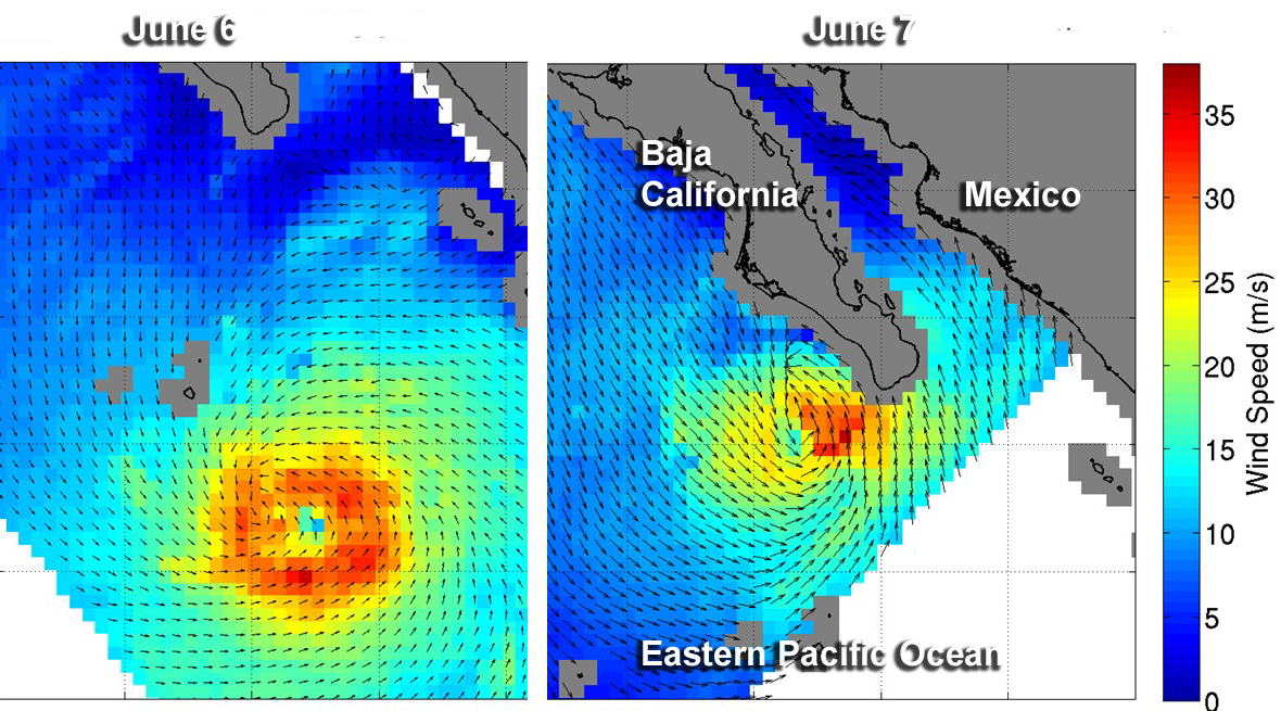
Also on June 7, the MODIS instrument aboard NASA’s Terra satellite captured a picture of the weakening Tropical Storm Blanca at 18:30 UTC (2:30 p.m. EDT). The image showed Blanca’s eye had disappeared and bands of thunderstorms still spiraled into the center from all quadrants.
At 11 a.m. EDT the center of Tropical Storm Blanca was located near latitude 25.1 North, longitude 112.0 West. Maximum sustained winds have decreased to near 40 mph (65 kph).
The National Hurricane Center (NHC) cited an unofficial weather station at Loreto, on the east coast of Baja California Sur, had recently reported a wind gust to 46 mph (74 kph).
The NHC said that Blanca was moving toward the north-northwest near 15 mph (24 kph), and this general motion is expected to continue through Tuesday. On the forecast track the center of Blanca will move near or over portions of the southern and central Baja California peninsula today through Tuesday.
Additional weakening is forecast during the next day or so, and Blanca is expected to degenerate into a remnant low by Tuesday, June 9. For local effects and updated forecasts, visit the NHC at www.nhc.noaa.gov.
Rob Gutro
NASA’s Goddard Space Flight Center
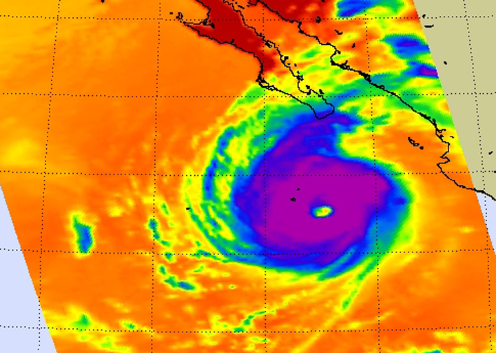
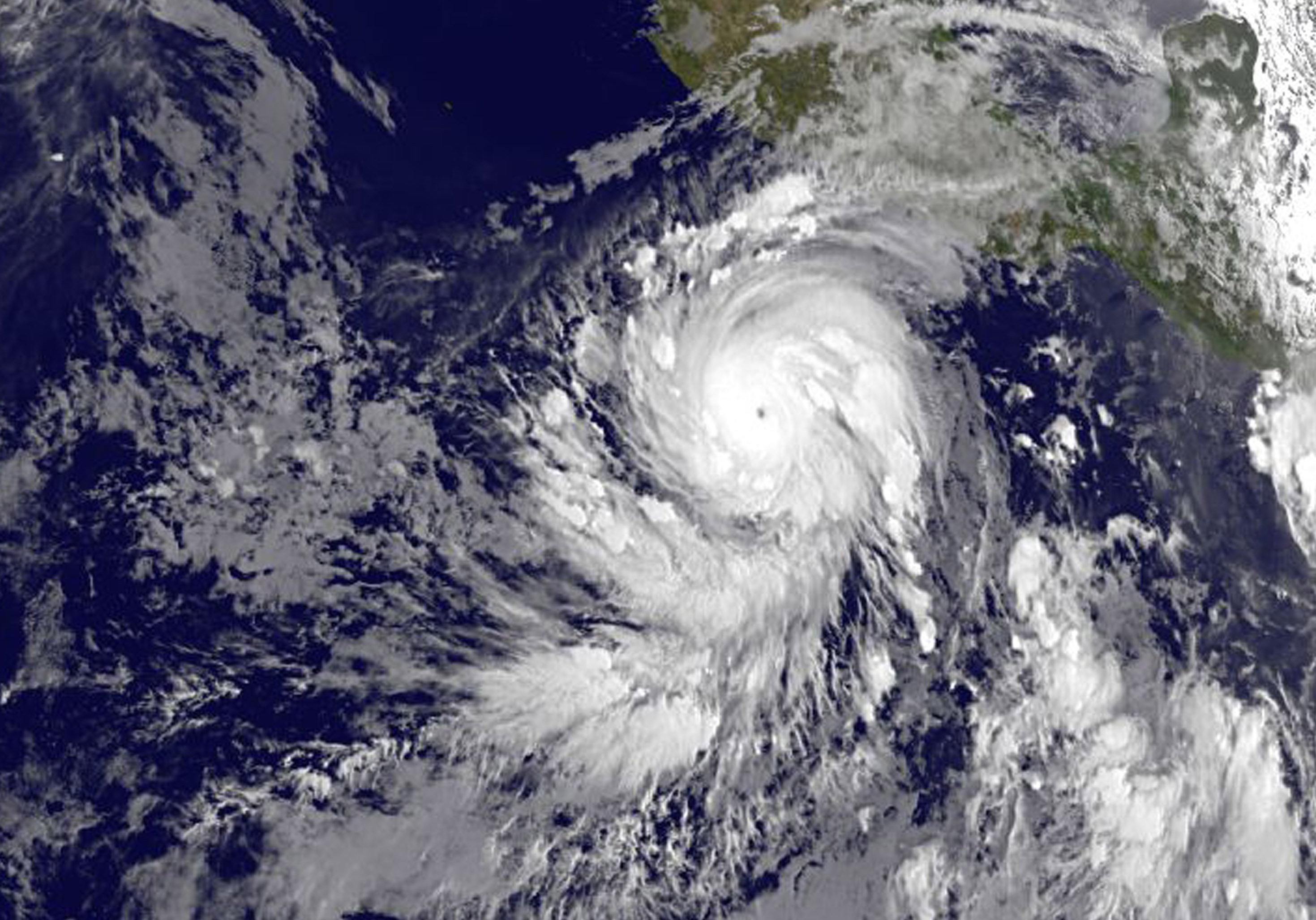
June 05, 2015 – NASA-NOAA’s Suomi NPP Satellite Gets Colorful Look at Hurricane Blanca

NASA-NOAA’s Suomi NPP satellite flew over Hurricane Blanca in the Eastern Pacific Ocean and gathered infrared data on the storm that was false-colored to show locations of the strongest thunderstorms within the storm.
The Visible Infrared Imaging Radiometer Suite or VIIRS instrument aboard the satellite gathered infrared data of the storm that was made into an image at the University of Wisconsin-Madison. The image was false-colored to show temperature. Coldest cloud top temperatures indicate higher, stronger, thunderstorms within a tropical cyclone. Those are typically the strongest storms with potential for heavy rainfall.
VIIRS is a scanning radiometer that collects visible and infrared imagery and “radiometric” measurements. Basically it means that VIIRS data is used to measure cloud and aerosol properties, ocean color, sea and land surface temperature, ice motion and temperature, fires, and Earth’s albedo (reflected light).
The VIIRS image from June 5 at 8:11 UTC (4:11 a.m. EDT) showed two areas of coldest cloud top temperatures and strongest storms were west-southwest and east-northeast of the center of Blanca’s circulation center.

On June 5 at 5 a.m. EDT (0900 UTC) Blanca’s maximum sustained winds were near 105 mph (165 kph) with higher gusts. The National Hurricane Center (NHC) forecast expects some strengthening during the next day or so. Weakening is forecast to begin by late Saturday.
At that time, NHC placed the center of Hurricane Blanca near latitude 14.3 North, longitude 106.2 West. That puts the center about 350 miles (560 km) south-southwest of Manzanillo, Mexico and about 640 miles (1,030 km) south-southeast of Cabo San Lucas, Mexico. The estimated minimum central pressure is 968 millibars (28.59 inches).
Blanca is moving toward the northwest near 10 mph (17 kph). A northwestward to north-northwestward motion at a similar forward speed is expected to continue through Saturday night.
Blanca has been stirring up surf along the coast of southwestern Mexico and will reach the Pacific coast of the Baja California peninsula and the southern Gulf of California later today, June 5. These swells are likely to cause life-threatening surf and rip current conditions.
On the forecast track, the center of Blanca will approach the southern Baja California peninsula on Sunday. NHC cautions that “Interests in the southern Baja California peninsula should monitor the progress of Blanca. A tropical storm or hurricane watch will likely be required for a portion of Baja California Sur later today.”
The NHC forecast track shows Blanca making landfall in the southeastern tip of Baja California on Sunday, June 7 and tracking north-northeast along the Baja California peninsula, for several days following.
Rob Gutro
NASA’s Goddard Space Flight Center
June 4, 2015 – Hurricane Blanca Now Appears Less Organized in NASA Infrared Light
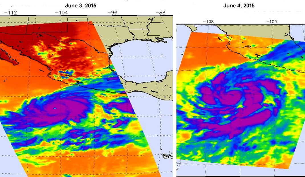
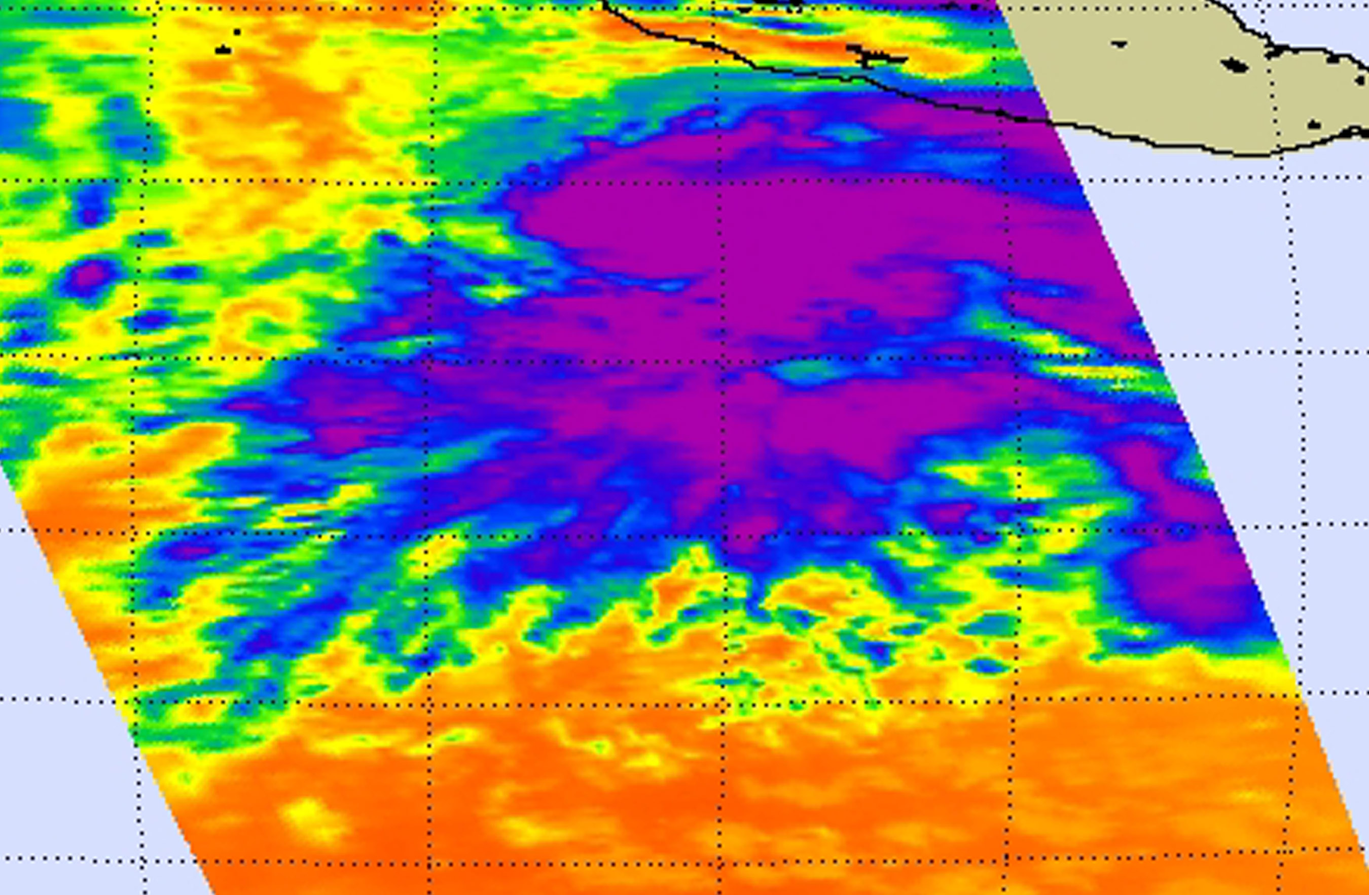
One of the instruments that flies aboard NASA’s Aqua satellite looks at tropical cyclones using infrared light. In a comparison of infrared data from June 3 and 4, images show that Hurricane Blanca had weakened and became less organized.
The Atmospheric Infrared Sounder or AIRS instrument that flies aboard NASA’s Aqua satellite measured cloud top temperatures in Blanca on June 3 at 20:17 UTC (4:23 p.m. EDT) when maximum sustained winds were near 140 mph (220 kph) with higher gusts. At the time, Blanca was a category 4 hurricane on the Saffir-Simpson Hurricane Wind Scale. The AIRS data showed a concentrated ring of powerful thunderstorms around a pinhole eye. Because infrared data measures temperature, AIRS saw that cloud top temperatures in the thunderstorms surrounding the tiny eye were as cold as -81.6F/-63.1C.
When Aqua passed over Blanca the following day, June 4 at 08:36 UTC (4:36 a.m. EDT) AIRS captured more information about the structure and cloud top temperatures. That satellite overpass showed that the bands of thunderstorms spiraling into the center had become fragmented and the pinhole eye that was visible on June 3 had disappeared from the AIRS image on June 4. At the time of the image, Blanca’s maximum sustained winds had dropped to 125 mph (205 kph). The 4 a.m. EDT discussion from the National Hurricane Center (NHC) noted “It is not clear whether the slight decrease in wind speed is a result of an eyewall replacement cycle, drier air wrapping into the circulation, or upwelling of cooler waters beneath the nearly stationary hurricane.”
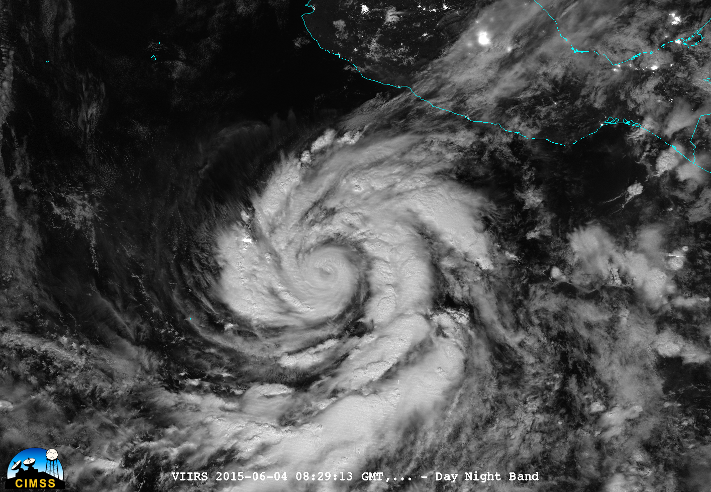
At 08:29 UTC (4:29 a.m. EDT), the VIIRS or Visible Infrared Imaging Radiometer Suite (VIIRS) instrument aboard NASA-NOAA’s Suomi satellite captured an infrared night-time picture of Hurricane Blanca several hundred miles west of the Mexican coast. The VIIRS image showed what appeared to be a cloud-filled eye and confirmed the bands of thunderstorms wrapping into it had become more fragmented.
On June 4, in the 11 a.m. EDT discussion, the NHC noted that “It appears that the combination of upwelling and an eyewall replacement cycle has resulted in significant weakening of Blanca during the past 18 hours or so. The eye is not as clear as it was yesterday, and the deep convection is no longer symmetric around what is left of the eye.”
Blanca is close enough to land to cause dangerous ocean swells. The National Hurricane Center cautioned that swells generated by Blanca will likely affect portions of the coast of southwestern Mexico during the next couple of days. These swells are likely to cause life-threatening surf and rip current conditions.
At 11 a.m. EDT (1500 UTC), the center of Hurricane Blanca was located near latitude 12.3 North, longitude 105.1 West. That places the center of Blanca about 465 miles (750 km) south of Manzanillo, Mexico, and about 795 miles (1,285 km) south-southeast of Cabo San Lucas.
Maximum sustained winds have decreased to near 110 mph (175 kph) with higher gusts. Blanca is moving toward the northwest near 3 mph (6 kph), and this general motion with an increase in forward speed is expected during the next 48 hours.
NHC noted that Blanca is forecast to re-strengthen some during the next 48 hours before starting to weaken again when it runs into increasing shear and cool waters as the storm approaches the Baja California peninsula. For the latest forecast updates, visit: www.nhc.noaa.gov.
Rob Gutro
NASA’s Goddard Space Flight Center
June 03, 2015 – Satellite Sees Hurricane Blanca Develop a Pinhole Eye
Tropical Storm Blanca strengthened into a hurricane while remaining almost stationary and about 400 miles west of the west coast of Mexico on June 3. NASA’s Terra satellite captured an image of Blanca before it strengthened, while NOAA’s GOES-West satellite saw the strengthening storm develop a pinhole eye.
Satellite data indicate that Blanca continues to rapidly strengthen as a small eye has become apparent in infrared imagery from NOAA’s GOES-West satellite during the early morning hours today, June 3.
Blanca hasn’t moved much in the last day but has continued to strengthen and during the early morning (local time) on June 3, the storm reached hurricane strength. Because of Blanca’s location and proximity to the coast, the National Hurricane Center cautions that swells generated by Blanca will begin affecting portions of the coast of southwestern Mexico during the next couple of days. These swells are likely to cause life-threatening surf and rip current conditions.

NOAA’s GOES-West satellite provided an infrared look at Blanca today, June 3 at 1200 UTC (8 a.m. EDT), after it strengthened into a hurricane today. The GOES image showed that Blanca had a tiny ‘pinhole” eye. Hurricane force winds extend outward up to 15 miles (30 km) from the center indicative of the tiny eye. Tropical storm force winds extend outward up to 90 miles (150 km). The estimated minimum central pressure is 964 millibars (28.47 inches).
At 5 a.m. EDT (0900 UTC), the center of Hurricane Blanca was located near latitude 12.6 North, longitude 104.7 West. That’s about 410 miles (655 km) south-southwest of Zihuatanejo, Mexico and 445 miles (701 km) south of Manzanillo, Mexico. The National Hurricane Center noted that Blanca is nearly stationary and is expected to move very little through tonight. The hurricane is forecast to accelerate toward the north-northwest on Thursday.
Satellite data indicate that the maximum sustained winds have increased to near 110 mph (175 km/h) with higher gusts. Rapid strengthening is forecast to continue, and Blanca is expected to become a major hurricane later today.
NHC forecaster Daniel Brown noted in the 5 a.m. EDT, June 3 discussion, “Rapid intensification is forecast to continue during the next 24 hours while Blanca remains over very warm water and in a low shear environment.”
The NHC forecast track takes Blanca on a northerly track and landfall on the southern tip of Baja California by Sunday, June 7 as a tropical storm. Residents of southern Baja California and mainland Mexico should begin preparations for Blanca’s arrival over the weekend.
Rob Gutro
NASA’s Goddard Space Flight Center
June 02, 2015 – NASA Looks at Tropical Storm Blanca’s Increasing Winds, Dropping Temperatures
Cooling cloud top temperatures and increasing winds are two indications that a tropical cyclone is organizing and strengthening. NASA’s Aqua satellite and the International Space Station’s RapidScat instrument helped meteorologists confirm those factors as Tropical Storm Blanca continues intensifying. In fact, the National Hurricane Center noted that environmental conditions are expected to allow Blanca to rapidly intensify to major hurricane status.
Blanca developed early Monday morning, June 1 and strengthened into a tropical cyclone later in the day.
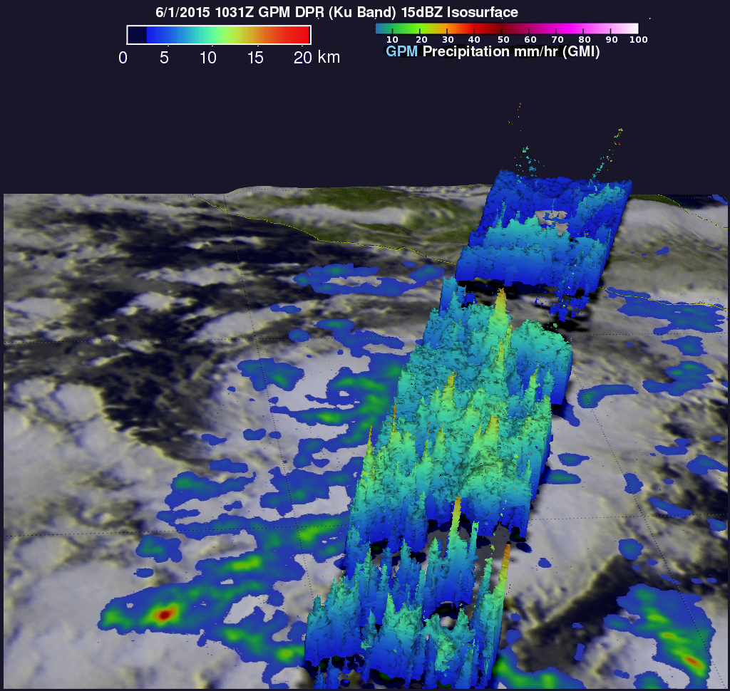
On June 1 at 10:31 UTC (6:31 a.m. EDT) data from the Global Precipitation Measurement (GPM) core observatory showed that several areas of intense rainfall were located east of Blanca’s center. Storm top heights were seen to frequently reach heights of over 15 kilometers (9.3 miles), indicating strong thunderstorms.
On June 1 at 20:29 UTC (4:29 p.m. EDT), the Atmospheric Infrared Sounder or AIRS instrument that flies aboard NASA’s Aqua satellite gathered infrared data on Blanca. AIRS data from this flyover showed that cloud top temperatures over a larger area were cooling, indicating there was more uplift in the atmosphere and cloud tops were extending higher into the troposphere (and were getting stronger). AIRS measured some very cold cloud tops near 210 kelvin (-81.6F/-63.1C) indicating very high, powerful thunderstorms with heavy rain.
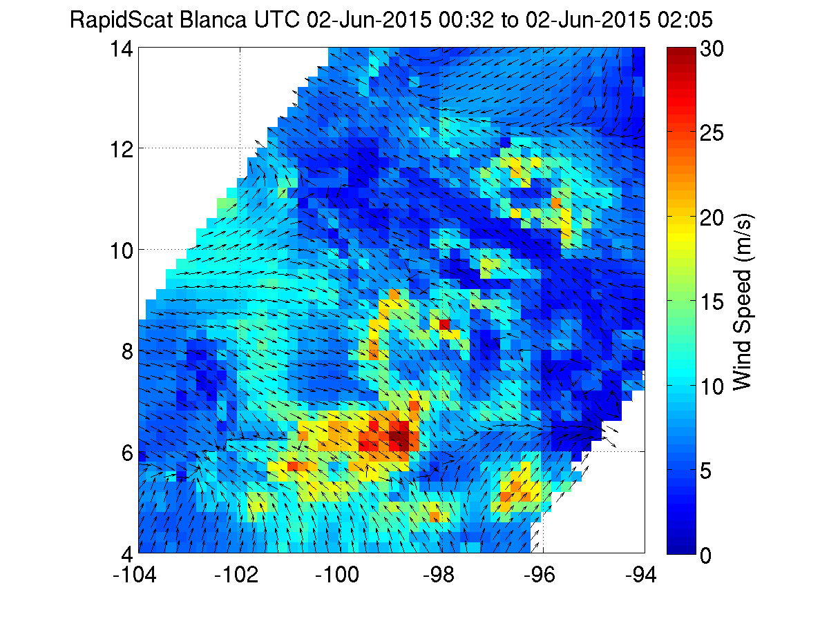
The International Space Station (ISS)-RapidScat instrument measures surface winds over the ocean. The ISS-RapidScat instrument gathered surface wind data today, Tuesday, June 2 from 00:35 to 2:05 UTC (June 1 from 8:35 p.m. EDT to 10:05 p.m. EDT). RapidScat identified the strongest winds in Blanca south of the center and as strong as 30 meters per second (67 mph/108 kph). Meanwhile, maximum sustained winds around the rest of Blanca’s center had increased from 45 (75 kph) to 50 mph (85 kph). Forecasters at the National Hurricane Center forecast those winds will continue to increase as Blanca strengthens into a hurricane.
The National Hurricane Center noted that the cloud pattern of Blanca has become a little better organized overnight with increased banding and very deep convection over the center.
At 5 a.m. EDT (9:00 UTC), the center of Tropical Storm Blanca was located near latitude 13.3 North and longitude 104.6 West. That puts Blanca’s center about 365 miles (585 km) southwest of Zihuatanejo, Mexico. Blanca was crawling toward the west near 1 mph (2 kph) and forecasters at the National Hurricane Center (NHC) expect a slow and erratic motion during the next couple of days. Blanca’s maximum sustained winds were near 50 mph (85 kph) with higher gusts.
The tropical storm is located in an environment that will enable rapid development over the next few days: low vertical wind shear, warm waters (over 26.6 C/80F) and a moist atmosphere. As a result, NHC forecasters expect rapid strengthening during the next couple of days. Blanca is forecast to become a major hurricane by Wednesday night or early Thursday.
Rob Gutro
NASA’s Goddard Space Flight Center
June 01, 2015 – NASA Sees Birth of Second Eastern Pacific Tropical Depression
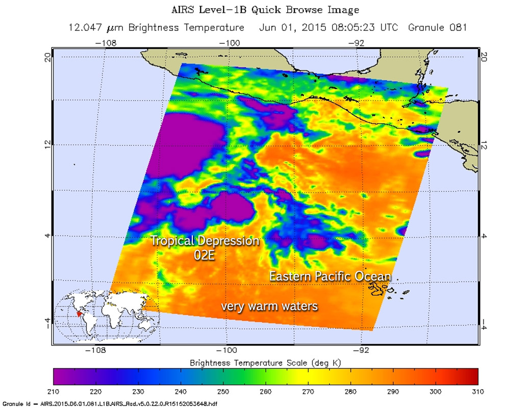
Less than a week after the first Eastern Pacific Ocean tropical cyclone was born, NASA’s Aqua satellite saw Tropical Depression 02E form to the east of Hurricane Andres.
Today, Monday, June 1, Hurricane Andres was a powerful category 4 hurricane on the Saffir-Simpson Scale and until today when Andres moved far enough away to stop suppressing the development of System 93E and allowed it to consolidate into Tropical Depression 02E (TD02E).
When NASA’s Aqua satellite passed over TD02E on June 1 at 8:04 UTC (4:04 a.m. EDT), the Atmospheric Infrared Sounder or AIRS instrument gathered data on the storm in infrared light. Infrared light shows temperature and measurement of cloud top temperatures provides valuable data on cloud heights. The higher the thunderstorms that make up a tropical cyclone, the colder they are, and the stronger the storm. In addition, stronger storms with temperatures at least as cold as -63F/-52C have the potential to drop heavy rainfall, which is what AIRS detected in the storms surrounding TD02E’s center.
At 5 a.m. EDT (0900 UTC), on June 1, the center of Tropical Depression Two-E was located near latitude 13.3 North, longitude 104.0 West. The National Hurricane Center (NHC) noted that the depression is moving toward the northwest near 6 mph (9 km/h). A slow west-northwestward to northwestward motion is expected today, followed by little motion tonight and Tuesday. Maximum sustained winds are near 35 mph (55 km/h) with higher gusts. The estimated minimum central pressure is 1006 mb (29.71 inches).
NHC forecasters said that TD02E is expected to become a tropical storm later in the day today, June 1.
Rob Gutro
NASA’s Goddard Space Flight Center