


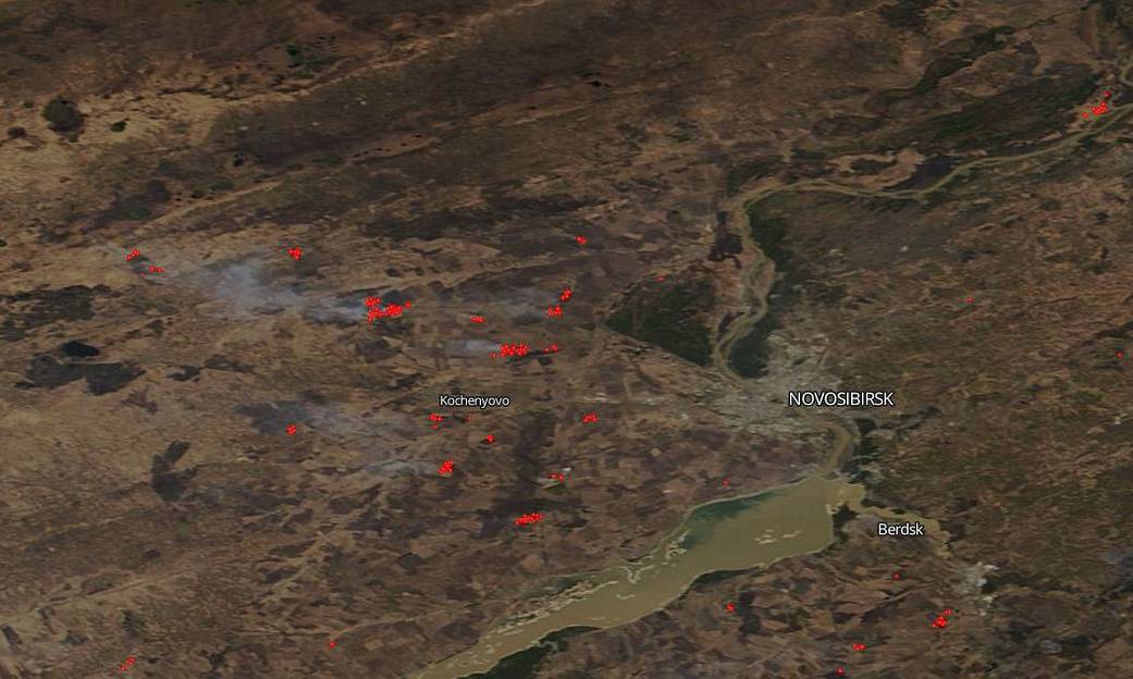
Wildfires in Siberia, Russia, are bringing even more misery to an area which is already on lockdown due to the coronavirus pandemic. On April 23, 2020, strong winds helped to push fires set by locals to dry grass out of control. The regions of Kemerovo and Novosibirsk among others have been the hardest hit to date. Nine Siberian regions have been affected by these wildfires. Clouds of smoke have swept across the Siberian landscape. This satellite image was collected on April 27, 2020 by the Terra satellite using its Moderate Resolution Imaging System (MODIS) instrument.
NASA’s satellite instruments are often the first to detect wildfires burning in remote regions, and the locations of new fires are sent directly to land managers worldwide within hours of the satellite overpass. Together, NASA instruments detect actively burning fires, track the transport of smoke from fires, provide information for fire management, and map the extent of changes to ecosystems, based on the extent and severity of burn scars. NASA has a fleet of Earth-observing instruments, many of which contribute to our understanding of fire in the Earth system. Satellites in orbit around the poles provide observations of the entire planet several times per day, whereas satellites in a geostationary orbit provide coarse-resolution imagery of fires, smoke and clouds every five to 15 minutes. For more information visit: https://www.nasa.gov/mission_pages/fires/main/missions/index.html
NASA’s Earth Observing System Data and Information System (EOSDIS) Worldview application provides the capability to interactively browse over 700 global, full-resolution satellite imagery layers and then download the underlying data. Many of the available imagery layers are updated within three hours of observation, essentially showing the entire Earth as it looks “right now.” Actively burning fires, detected by thermal bands, are shown as red points. Some of the red points may have smoke rising from them which is indicative for fire. Image Courtesy: NASA Worldview, Earth Observing System Data and Information System (EOSDIS). Caption: Lynn Jenner