


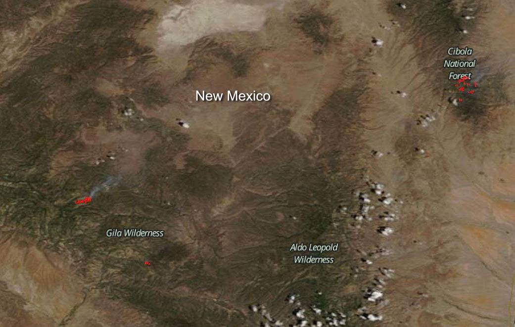
NASA’s Terra satellite peered down from space to capture an image of the three fires visible in New Mexico on July 01, 2020. The fires pictured in this image are the Cub Fire, the Good Fire and the Vics Peak fire.
The Cub fire is located about 1-mile northeast of Cub Mountain, near the West Fork of the Gila River in the Gila National Forest. The fire started on June 28, 2020 with a lightning strike. As of July 01, the fire is 385 acres in size and continues to burn within the boundary of the Whitewater-Baldy Fire scar from 2012. The fire is burning north towards the West Fork of the Gila River and east downhill on Cub Mountain. In the image this fire is located northwest of the Gila Wilderness.
The Good fire is located 1 1/2-miles southwest of Gila Cliff Dwellings National Monument and it began on June 28, 2020 also with a lightning strike, mostly likely from the same storm that started the Cub Fire. As of July 01 the fire is 17,200 acres and is 53% contained. The fire is burning in timber, tall grass, and brush. In the image this fire is located south of the Gila Wilderness.
For these two fires the local weather should: “begin transitioning to a more humid, and rainy period. A sub-tropical high over central Mexico will slowly drift north over the next week-over New Mexico and Arizona by this weekend. This will move moisture up into the area and allow it to persist through at least this weekend and probably into the beginning of next week. Low level moisture should be just enough to rule out dry lightning and give some potential decent rainfall around our fires. No significant large scale winds expected through the weekend-however storm environment over the next several days could lead to strong winds near storms,” according to local forecasters. This may bring needed relief to that area.
The Vics Peak fire began on June 15, 2020 also with a lightning strike. As of July 01, the fire has burned 10,624 acres and is 38% contained. The fire is burning near Vics Peak toward the southern end of the San Mateo Mountains in mixed conifer and ponderosa pine at the higher elevations, and pinyon/juniper and mountain mahogany at the mid-elevations, according to Inciweb. In this image it is located near the Cibola National Forest. The projected activity for this fire is: “moderate fire spread potential to high due to hot/dry weather, potential thunderstorms, increased winds and lower relative humidity along with possible aerial ignition operations in the wilderness” per Inciweb.
NASA’s satellite instruments are often the first to detect wildfires burning in remote regions, and the locations of new fires are sent directly to land managers worldwide within hours of the satellite overpass. Together, NASA instruments detect actively burning fires, track the transport of smoke from fires, provide information for fire management, and map the extent of changes to ecosystems, based on the extent and severity of burn scars. NASA has a fleet of Earth-observing instruments, many of which contribute to our understanding of fire in the Earth system. Satellites in orbit around the poles provide observations of the entire planet several times per day, whereas satellites in a geostationary orbit provide coarse-resolution imagery of fires, smoke and clouds every five to 15 minutes. For more information visit: https://www.nasa.gov/mission_pages/fires/main/missions/index.html
NASA’s Earth Observing System Data and Information System (EOSDIS) Worldview application provides the capability to interactively browse over 700 global, full-resolution satellite imagery layers and then download the underlying data. Many of the available imagery layers are updated within three hours of observation, essentially showing the entire Earth as it looks “right now.” Actively burning fires, detected by thermal bands, are shown as red points. Image Courtesy: NASA Worldview, Earth Observing System Data and Information System (EOSDIS). Caption: Lynn Jenner with information from Inciweb.