


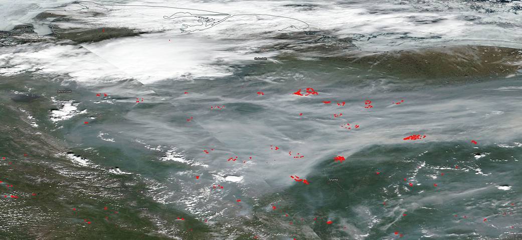
On June 21, 2020, NOAA/NASA’s Suomi NPP satellite using the VIIRS instrument (Visible Infrared Imaging Radiometer Suite) captured this natural-color image of fires that have broken out across the Siberian section of Russia. The red dots that are spread across the landscape in the image are where the satellite has detected temperatures significantly higher than surrounding area. That combined with the smoke rising is indicator for fire. The VIIRS instrument which collected this image is a 22-band radiometer which collects infrared and visible light data to observe weather, climate, oceans, nightlight, wildfires, movement of ice, and changes in vegetation and landforms. Suomi NPP is the first Earth-observing satellite to measure both global climate changes and key weather variables. Suomi NPP is managed by NASA, NOAA and the U.S. Department of Defense.
Many outlets, including NASA, have reported that temperatures in the northernmost climes have have been running much higher than usual and the Siberian town of Verkhoyansk may have hit a record setting temperature of 100 degrees Fahrenheit. That is about 36 degrees F higher than the average temperatures in that area for June. Combining rising temperatures with the peat, underbrush, and grass that grows across much of the Siberian tundra, fires are more likely to break out and to spread. This year the fire season began weeks earlier than usual and fires that have broken out have been larger and more dangerous than in past seasons. This hot weather and the overabundance of fuel will provide the elements to ensure these wildfires will continue throughout the season, most likely.
NASA’s satellite instruments are often the first to detect wildfires burning in remote regions, and the locations of new fires are sent directly to land managers worldwide within hours of the satellite overpass. Together, NASA instruments detect actively burning fires, track the transport of smoke from fires, provide information for fire management, and map the extent of changes to ecosystems, based on the extent and severity of burn scars. NASA has a fleet of Earth-observing instruments, many of which contribute to our understanding of fire in the Earth system. Satellites in orbit around the poles provide observations of the entire planet several times per day, whereas satellites in a geostationary orbit provide coarse-resolution imagery of fires, smoke and clouds every five to 15 minutes. For more information visit: https://www.nasa.gov/mission_pages/fires/main/missions/index.html
NASA’s Earth Observing System Data and Information System (EOSDIS) Worldview application provides the capability to interactively browse over 700 global, full-resolution satellite imagery layers and then download the underlying data. Many of the available imagery layers are updated within three hours of observation, essentially showing the entire Earth as it looks “right now.” Actively burning fires, detected by thermal bands, are shown as red points. Image Courtesy: NASA Worldview, Earth Observing System Data and Information System (EOSDIS). Caption: Lynn Jenner