


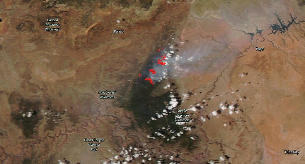
NASA’s Aqua satellite captured this image of the ongoing Mangum fire, twenty-four miles south of Fredonia, Ariz., on June 18, 2020. This fire began on June 08, 2020 and the origin of the fire is still under investigation. The fire has burned 54,845 acres and is 3 percent contained.
Yesterday, June 18, proved difficult as a change in wind direction moved the fire towards the east which provided all new fuel for the fire in the form of sage brush grassland and piñon-juniper. The change in wind direction also forced the evacuation of three residences. Forecasters are predicting a west to northwest wind today (Jun. 19), and as such, fire behavior will be active with the wind potentially pushing the fire southeastward. The North Rim of the Grand Canyon remains inaccessible. The smoke from the fire has also been settling inside the Grand Canyon and taking longer to dissipate throughout the day.

NASA’s satellite instruments are often the first to detect wildfires burning in remote regions, and the locations of new fires are sent directly to land managers worldwide within hours of the satellite overpass. Together, NASA instruments detect actively burning fires, track the transport of smoke from fires, provide information for fire management, and map the extent of changes to ecosystems, based on the extent and severity of burn scars. NASA has a fleet of Earth-observing instruments, many of which contribute to our understanding of fire in the Earth system. Satellites in orbit around the poles provide observations of the entire planet several times per day, whereas satellites in a geostationary orbit provide coarse-resolution imagery of fires, smoke and clouds every five to 15 minutes. For more information visit: https://www.nasa.gov/mission_pages/fires/main/missions/index.html
NASA’s Earth Observing System Data and Information System (EOSDIS) Worldview application provides the capability to interactively browse over 700 global, full-resolution satellite imagery layers and then download the underlying data. Many of the available imagery layers are updated within three hours of observation, essentially showing the entire Earth as it looks “right now.” Actively burning fires, detected by thermal bands, are shown as red points. Image Courtesy: NASA Worldview, Earth Observing System Data and Information System (EOSDIS). Caption: Lynn Jenner with information from Inciweb and the Mangum Official Fire page on Facebook.