


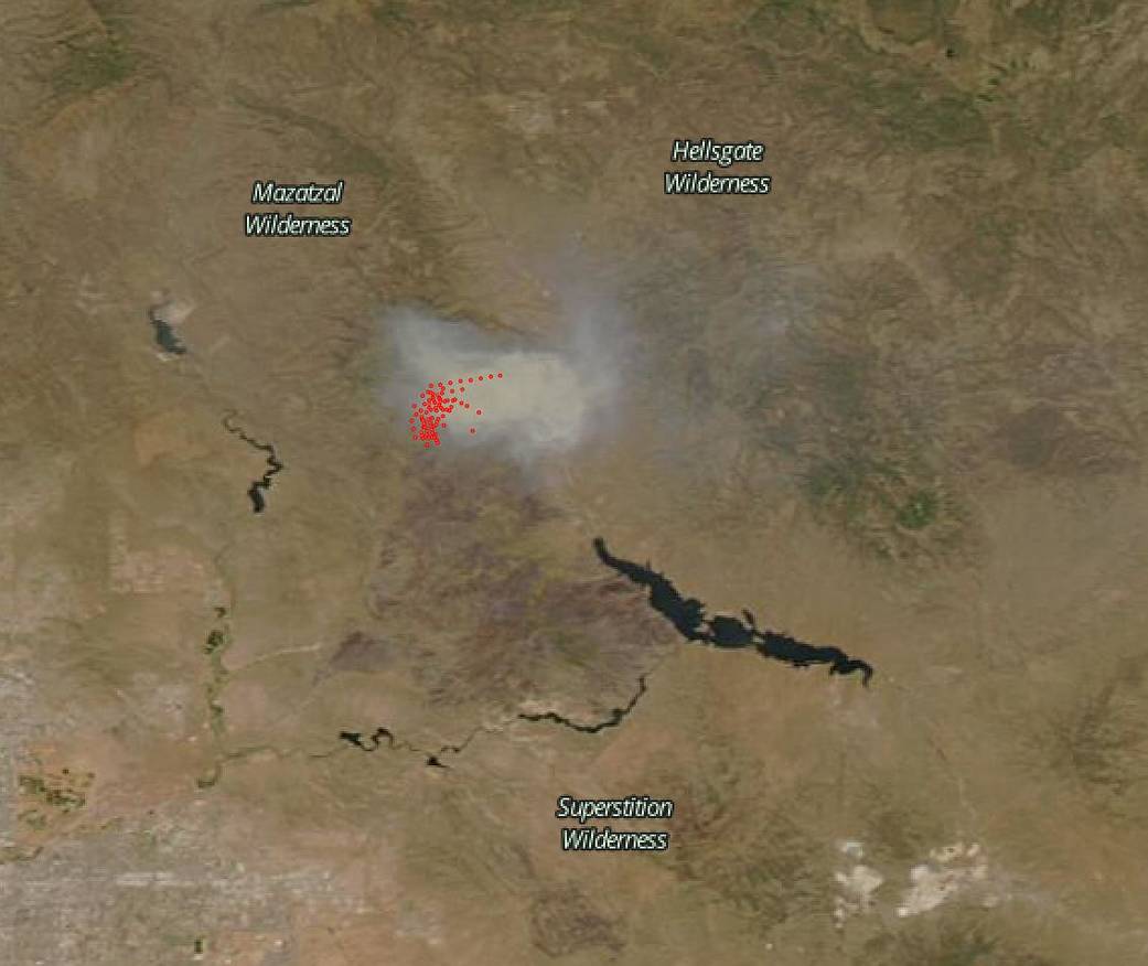
NASA’s Aqua satellite captured this satellite image of the Bush Fire in Arizona on June 21, 2020 with the MODIS (Moderate Resolution Imaging Spectroradiomater) instrument onboard. The Bush Fire is now the nation’s largest fire at present. This human-caused fire which began on June 13, 2020, is now one of the five largest fires in Arizona’s history. This fire has already consumed 184,674 acres, and 10,000 acres were consumed in an overnight period from Saturday to Sunday. The fire is 42 percent contained. The dark reddish-brown area in the image is the land that has been consumed by fire during the blaze.
From Inciweb: “Fire has grown to the North, East and South with un-burned islands that have the potential to ignite in the afternoon and evening hours. A new fire start is reported at 1,500 acres along I-17 North of New River. Reports of smoke impacts. This is being monitored and will report further if this becomes a larger or prolonged smoke impact.”

After a wet winter that allowed a large amount of underbrush and residual grass growth has now turned dry in the summer heat causing more fuel to be available for forest fires to take root and explode. There have already been 70 fires that have occurred in Arizona just this year. This fire season looks to be highly destructive if present conditions continue.
NASA’s satellite instruments are often the first to detect wildfires burning in remote regions, and the locations of new fires are sent directly to land managers worldwide within hours of the satellite overpass. Together, NASA instruments detect actively burning fires, track the transport of smoke from fires, provide information for fire management, and map the extent of changes to ecosystems, based on the extent and severity of burn scars. NASA has a fleet of Earth-observing instruments, many of which contribute to our understanding of fire in the Earth system. Satellites in orbit around the poles provide observations of the entire planet several times per day, whereas satellites in a geostationary orbit provide coarse-resolution imagery of fires, smoke and clouds every five to 15 minutes. For more information visit: https://www.nasa.gov/mission_pages/fires/main/missions/index.html
NASA’s Earth Observing System Data and Information System (EOSDIS) Worldview application provides the capability to interactively browse over 700 global, full-resolution satellite imagery layers and then download the underlying data. Many of the available imagery layers are updated within three hours of observation, essentially showing the entire Earth as it looks “right now.” Actively burning fires, detected by thermal bands, are shown as red points. Image Courtesy: NASA Worldview, Earth Observing System Data and Information System (EOSDIS). Caption: Lynn Jenner with information from Inciweb.