


Fire season in Australia has been difficult for the entire continent and that includes New South Wales where three large bushfires have broken out. The New South Wales Rural Fires Service has this information about the three distinct fires.
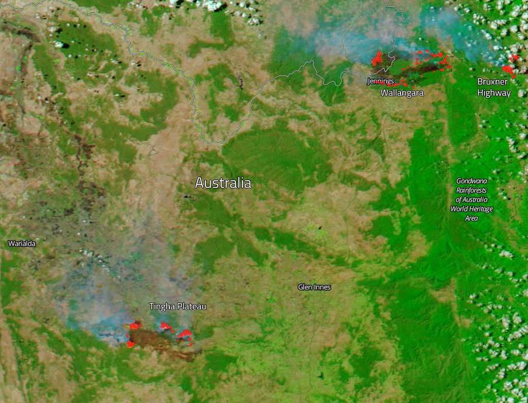
A bush fire is burning in Wallangarra/Jennings area, north of Tenterfield. It continues to burn on a number of fronts in this remote area, including in the area of Bald Rock National Park and the Boonoo State Forest, north of Tenterfield, between Mount Lindesay Road and Bruxner Highway. To date the fire has burned more than 28,700 ha (70,919 acres) and is being controlled. Over the coming days firefighters will take advantage of more favorable weather in an effort to control the fire.
The second bushfire which is quite near the Wallangarra area fire is the Bruxner Highway fire that is burning west of Tabulam. This bushfire is still being classified as “out of control.” Local news outlets have attributed this outbreak to a trash fire that was left unattended and began to burn out of control. This fire was set by a local resident during a complete fire ban. To date ten homes and many other buildings have been destroyed including horse stables at a local racecourse, along with the over 4000 ha (9884 acres) burnt in the Tabulam bushfire by late Thursday. An emergency warning remains in place for the Bruxner Highway fire as it creeps towards homes at Tabulam. Residents are being warned to prepare to leave and monitor the situation with firefighters on the ground.
The third bushfire that is being fought is the Tingha Plateau fire. This fire is burning in the Tingha, Old Mill and Stanborough area and has burned more than 22,708 ha (56,112 acres). It is currently being controlled by firefighters. Strong winds that were predicted to impact the fire have not been experienced and firefighters will undertake back burning when conditions are favorable. It should be noted that residents should continue to monitor the situation and take advice from firefighters on the ground.
NASA’s Earth Observing System Data and Information System (EOSDIS) Worldview application provides the capability to interactively browse over 700 global, full-resolution satellite imagery layers and then download the underlying data. Many of the available imagery layers are updated within three hours of observation, essentially showing the entire Earth as it looks “right now. This false-color NOAA/NASA Suomi NPP satellite image was collected on February 15, 2019 using the VIIIRS (Visible Infrared Imaging Radiometer Suite) instrument onboard. Actively burning fires, detected by thermal bands, are shown as red points. Image Courtesy: NASA Worldview, Earth Observing System Data and Information System (EOSDIS). Caption: Lynn Jenner with information from the New South Wales Rural Fire Service