


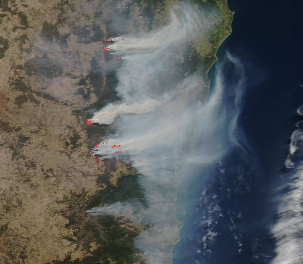
NASA’s Aqua satellite passed over the Australian state of New South Wales on September 12, 2019 and observed a huge swath of fires up and down the coast. The New South Wales Rural Fire Services Twitter account reports that: “At midday [Sep 12] there are 45 bush and grass fires burning across the state, with 14 uncontained. All fires are at Advice as firefighters and aircraft continue to work on containment.” The New South Wales Rural Fire Services website has listed these three fires as major and the site gives these statistics on each of the three bushfires:
- “The Bees Nest bush fire is burning north of Ebor and to the north west of Dorrigo. The fire is currently more than 86,950 hectares [214,858 acres] and is being controlled. The fire continues to burn on multiple fronts within the Guy Fawkes National Park, the Mount Hyland Nature Reserve and Nymboi Binderay National Park. The fire is burning close to homes and properties, Firefighters remain on scene to continue to protect properties in the area.
- The Kingsgate Red Range bush fire is on bush land approximately 15 kilometres east of Glen Innes, in the area of the Brother State Forest. The fire has burnt more than 2700 hectares [6,671 acres] and is out of control. The fire is currently burning within the Brother State Forest to the west of Newton Boyd. Firefighters continue to monitor the fire and have undertaken a number of backburns on the western edge of the fire. These burns will continue as conditions allow.
- The Long Gully Rd. bush fire is burning in bushland south of Drake, Tabulam and the Bruxner Highway. The fire has burnt more than 49,400 hectares [122,070 acres] and is being controlled. The fire is continuing to spread in a number of directions due to winds and local terrain. The fire continues to burn to the west of the Clarence River in the Girard State Forest. Firefighters are currently undertaking backburning in a number of areas across the fire ground, this will continue as conditions allow. People in the area may notice an increase of smoke and fire as these burns are undertaken.”
Bushfires are typically seen in the southern states of New South Wales and Victoria where the bushfire season runs from October to April. The difference this year is that hot and windy conditions have been unprecedented this early in the season and are the result of record winter warmth and little rainfall over the past two years putting the area into an ongoing drought. Friday and Saturday (Sep. 13/14) are expected to bring more unfavorable weather with hotter, drier and windier conditions.
NASA’s Earth Observing System Data and Information System (EOSDIS) Worldview application provides the capability to interactively browse over 700 global, full-resolution satellite imagery layers and then download the underlying data. Many of the available imagery layers are updated within three hours of observation, essentially showing the entire Earth as it looks “right now.” This satellite image was collected on September 12, 2019 with the Aqua satellite using the Moderate Resolution Imaging Spectroradiometer (MODIS) instrument. Actively burning fires, detected by thermal bands, are shown as red points. Image Courtesy: NASA Worldview, Earth Observing System Data and Information System (EOSDIS). Caption: Lynn Jenner with information from New South Wales Rural Fire Services.