


Australia is experiencing its hottest summer on record. Australia’s Bureau of Meteorology has declared this season has surpassed the previous hottest summer which was set six years ago in 2012-2013. During that summer the average temperatures were 1.28C above normal throughout the summer. In 2018-2019 the mean temperatures were at least 2C higher than normal. What is the outcome of such temperature rises other than the indication that global warming and climate change are both real? One thing that occurs during hotter temperatures are bushfires. This year the bushfire season in Australia has been particularly difficult. In the territory of Victoria, 19 bushfires are currently burning out of control. With the forecast of more thunderstorms in the territory, more bushfires could start with lightning strikes.
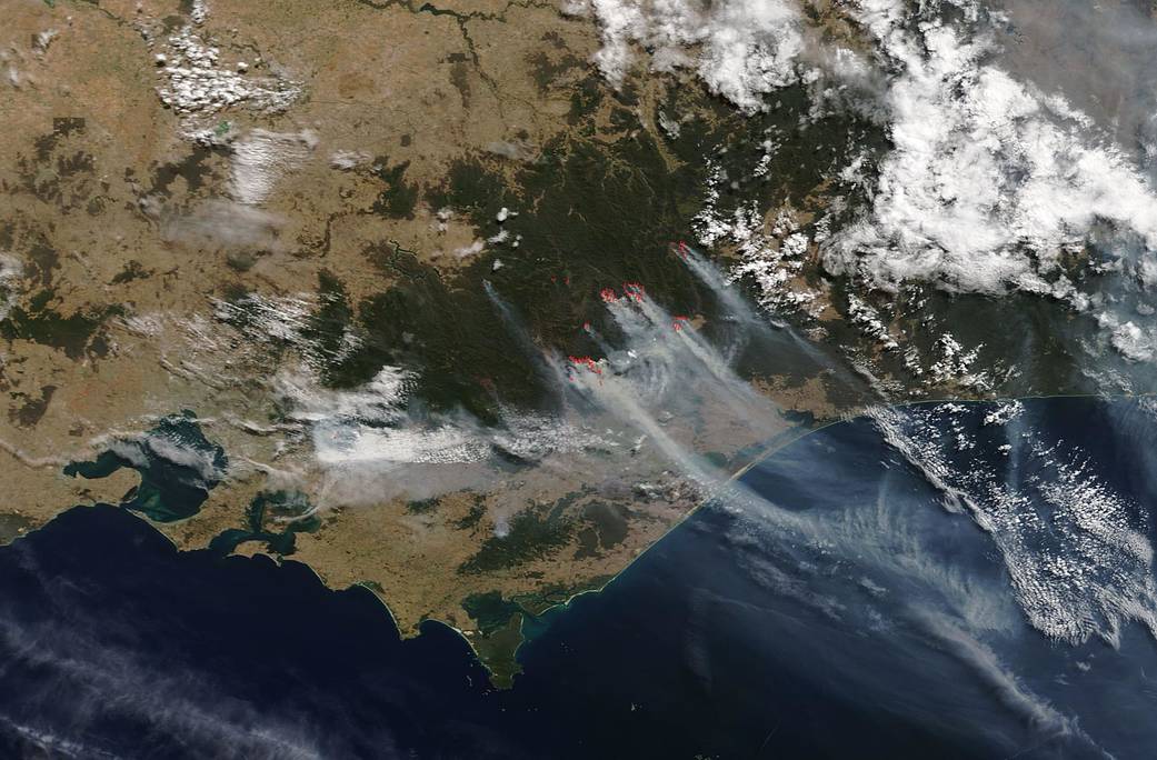
The fires in the Dinner Plain area which started on March 4, 2019, are the far right of the image and to the north. The Emergency Victoria website has the following information on this fire area:
- The Watch and Act message for Dinner Plain has been downgraded. There is no imminent danger to Dinner Plain.
- There is a bushfire centered 8Km South West of Dinner Plain at Mayford Tuckalong Spur that is not yet under control.
- This fire has grown to 1600 ha and is continuing to burn to the east of the Dargo High Plains road and has crossed the Dargo River to the west.
- The fire is traveling in a south easterly direction.
- Ground crews and aircraft are actively fighting this fire.
- The fire’s direction is being influenced by high altitude winds which may be different to what is experienced on the ground.
The Dargo fire which is seen in the image as the fire to the left of the Dinner Plain fire started on March 04, 2019. The fire spread so quickly that residents were told to seek shelter since it was too late to leave. A total fire ban has been declared across Victoria for Sunday. Weather forecasters are predicting more high temperatures without much relief. According to the Emergency Victoria website:
- There is one bushfire 1.6 km south west of Dargo and 2 other located north west of Dargo that are not yet under control.
- Fire behavior on the fire closest to Dargo has significantly reduced with rain falling across the fireground.
- The 2 fires north west of Dargo continue to burn towards each other, however progress has slowed significantly.
Another fire broke out in the Licola area which is the area to the left of the Drago fire on the image. It is 17,000 ha (42,000 acres) in size and is impacting the area around Mount Useful and the Avon River. Over 2,000 firefighters are battling the blazes at present. According to the Emergency Victoria website:
- The bushfire 3.5 km south east of Licola is not yet under control.
- This fire has progressed slowly to the north east and east.
- Ground crews and heavy machinery are working to build fire breaks around private property to the east and south east of Licola township.
Forecasters are predicting southwesterly winds and thunderstorm activities which could mean more bushfires in the alpine areas. The weather change could also bring rain or even snow to higher elevations but the amount of precipitation needed to drown the fires is unlikely. More likely is that these fires will be burning for quite some time until significant rainfall comes to the area.

NASA’s Earth Observing System Data and Information System (EOSDIS) Worldview application provides the capability to interactively browse over 700 global, full-resolution satellite imagery layers and then download the underlying data. Many of the available imagery layers are updated within three hours of observation, essentially showing the entire Earth as it looks “right now.” This Terra satellite image was collected on March 04, 2019. Actively burning fires, detected by thermal bands, are shown as red points. Image Courtesy: NASA Worldview, Earth Observing System Data and Information System (EOSDIS). Caption: Lynn Jenner with information from the Bureau of Meteorology and the Emergency Victoria website.