


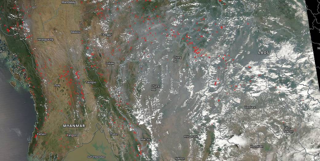
Fires across the expanse of Thailand, Myanmar, and Laos indicate that farmers are setting old fields ablaze in anticipation of the upcoming growing season. It is the location, widespread nature, and number of fires in this satellite image that suggest that these fires were deliberately set to manage land. Often farmers use fires to return nutrients to the soil and to clear fields of unwanted plants and detritus. While fire helps enhance crops and grasses for pasture, the fires also produce smoke that degrades air quality. In this image the smoke/haze from these fires reaches across the entire image covering several countries and is being carried eastward towards the Philippines.
The smoke released by any type of fire (forest, brush, crop, structure, tires, waste or wood burning) is a mixture of particles and chemicals produced by incomplete burning of carbon-containing materials. All smoke contains carbon monoxide, carbon dioxide and particulate matter (PM or soot). Smoke can contain many different chemicals, including aldehydes, acid gases, sulfur dioxide, nitrogen oxides, polycyclic aromatic hydrocarbons (PAHs), benzene, toluene, styrene, metals and dioxins. The type and amount of particles and chemicals in smoke varies depending on what is burning, how much oxygen is available, and the burn temperature.
NASA’s Earth Observing System Data and Information System (EOSDIS) Worldview application provides the capability to interactively browse over 700 global, full-resolution satellite imagery layers and then download the underlying data. Many of the available imagery layers are updated within three hours of observation, essentially showing the entire Earth as it looks “right now.” This natural-color satellite image was collected by the Moderate Resolution Imaging Spectroradiometer (MODIS) aboard the Aqua satellite on April 04, 2019. Actively burning fires, detected by thermal bands, are shown as red points. Image Courtesy: NASA Worldview, Earth Observing System Data and Information System (EOSDIS). Caption: Lynn Jenner