


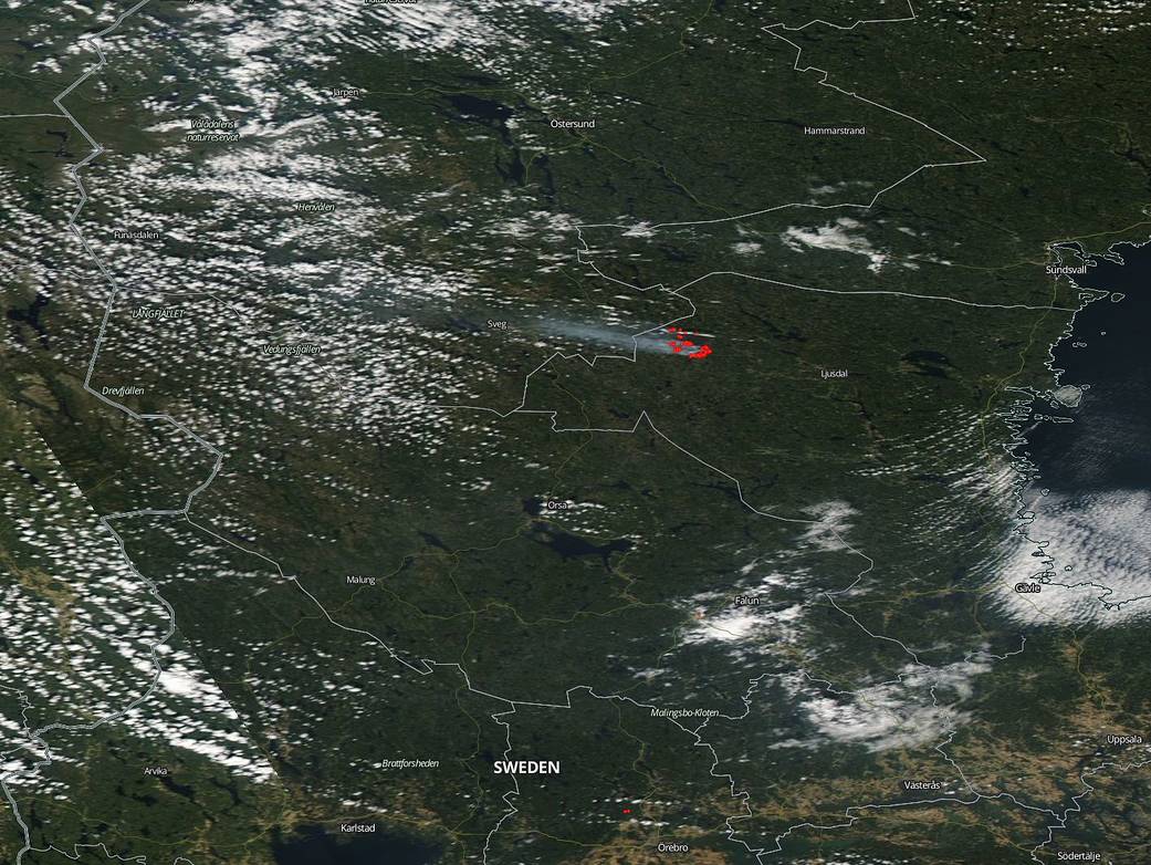
Sweden’s unusual weather pattern this summer has resulted in an unusual number of wildfires across the country as well as in an unusual area — the Arctic Circle. Normally this area sees temperate weather with plenty of showers throughout the summer. Not so this year with areas in Lapland seeing wildfires of unprecedented size and duration. Last year the city of Ljusdal, where the fires seen in this satellite image are located, had temperatures in July that ranged from daytime highs of 57F to 73F. This year the range has been much higher with most highs for the time period after July 10 being between 64F and 90F. But the most telling difference is the amount of rainfall. This year the area affected has seen almost no rain at all since the beginning of May. Lightning strikes are likely to become more frequent as more energy enters the atmosphere from a planet that continues to warm. Weather fronts are also lingering longer which makes their impacts more pronounced. Areas are seeing many more periods of drought and also periods of flooding. Weather is just becoming more extreme as Earth heats up.
As a result of high temperatures, extremely low humidity creating drought conditions, the trees and grasses dried out and became tinder. All the area needed was just one spark to set off the 60 plus wildfires that Sweden has been fighting this past month. These fires forced evacuations of three communities and disrupted rail service. France dispatched soldiers, Italy sent water bombing aircraft, while Denmark, Norway and Estonia also provided fire fighters and equipment.
Over the past weekend, much needed rain entered the area and helped out firefighters immensely. There were still 12 fires burning across the country after the rain but that does not negate the huge improvement over the previous week when between 30 and 70 fires were burning each day.
NASA’s Aqua satellite captured this image of the fire and smoke blowing from it on July 27, 2018 with the Moderate Resolution Imaging Spectroradiometer, MODIS, instrument. Images from the 28-20 were obscured by clouds which were the clouds that brought the much needed rain to the area. Actively burning areas (hot spots), detected by MODIS’s thermal bands, are outlined in red. Each hot spot is an area where the thermal detectors on the MODIS instrument recognized temperatures higher than background. When accompanied by plumes of smoke, as in this image, such hot spots are diagnostic for fire. NASA image courtesy of the NASA/Goddard Space Flight Center Earth Science Data and Information System (ESDIS) project. Caption by Lynn Jenner with information news sources in Sweden.