


![Request for Information – Potential [Placeholder for Prize]](https://assets.science.nasa.gov/dynamicimage/assets/science/psd/solar/2023/09/s/solarsystem_0.jpg?w=1024)


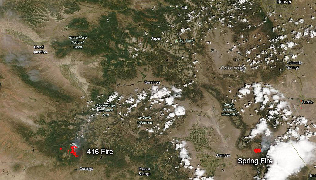
At least two large fires have taken up residence in Colorado and don’t look anxious to be put out any time soon. The 416 Fire located 13 miles north of Durango, Colorado, has been burning since June, 1, 2018, and has consumed 41,617 acres of timber brush, timber, and live fuels that are unseasonably dry due to prolonged drought in the area. The area has a red flag warning meaning that relief is not in sight so far. Fire activity continues to increase due to high temperatures, low humidity, gusty winds, and unstable atmosphere. Fuels under 10,000 feet in elevation are continuing to dry out after precipitation event in mid-June. Near critical fire weather conditions through most of next week. The cause of this blaze is unknown. No homes are currently under evacuation orders, but some residences remain under pre-evacuation notice. Structure protection is in place.
The “no evacuation orders” is not the case in Spring Fire that is just east of Fort Garland, Colorado and 160 miles south of Denver. This blaze began on Wednesday, June 27, and has already grown to 14,424 acres and is 0% contained. Structures have been destroyed and fire managers are not sure how many were compromised. The fire is located right near the Sangre de Cristo Mountains. Residents of about 350 homes were ordered to evacuate. Others have been told to prepare to leave, but officials were uncertain of the number. Evacuation orders were put in place for Forbes Park, a housing development started by multimillionaire Malcolm Forbes in the 1970s. These residences range from large homes to cabins.
Hot, dry and windy weather has raised the fire danger across much of Colorado, Utah, Nevada and Arizona.
NASA’s Aqua satellite captured this image of the fire and smoke blowing from it on June 28, 2018 with the Moderate Resolution Imaging Spectroradiometer, MODIS, instrument. Actively burning areas (hot spots), detected by MODIS’s thermal bands, are outlined in red. Each hot spot is an area where the thermal detectors on the MODIS instrument recognized temperatures higher than background. When accompanied by plumes of smoke, as in this image, such hot spots are diagnostic for fire. NASA image courtesy of the NASA/Goddard Space Flight Center Earth Science Data and Information System (ESDIS) project. Caption by Lynn Jenner with information from Inciweb and Costilla County Twitter feed.