


The United States is the middle of an unfortunate spate of natural disasters. In Texas the aftermath of Hurricane Harvey is causing widespread flooding, and in the western United States just the opposite–dry conditions and extreme heat–are causing widespread forest fires.
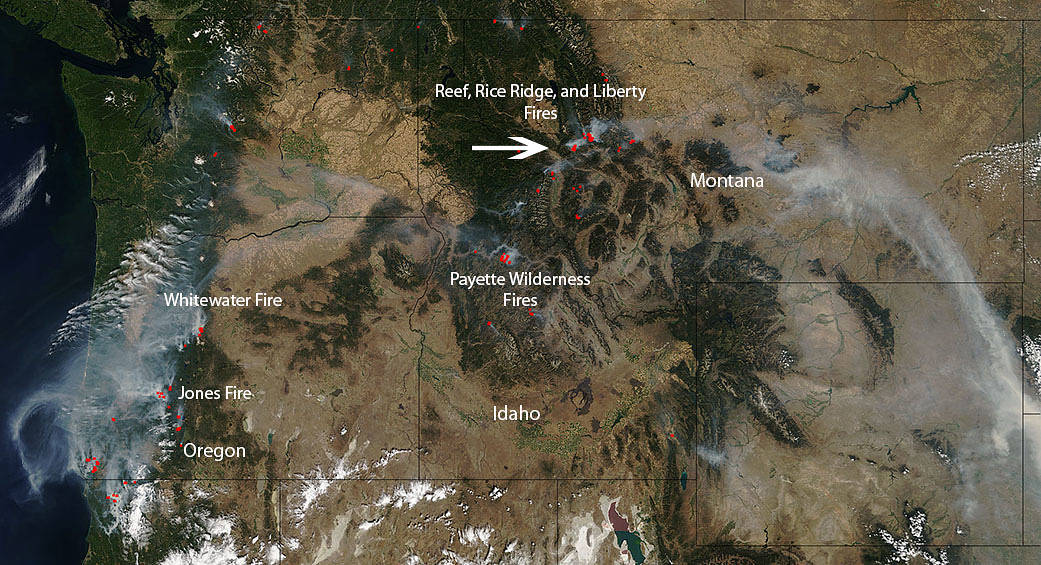
There are dozens of wildfires seen in this Terra satellite image taken on August 27, 2017. Several wildfires have been identified in the image and will be discussed in further detail.
In Oregon, the Whitewater and Jones fires are located in the upper and middle parts of the state. The Whitewater fire is burning in an area that is 13 miles east of Detroit, Oregon. It is currently 10,432 acres in size and was discovered on July 23, 2017. It is believed that the fire began as a lightning strike. The forecasted weather in the area is not conducive to optimal firefighting. Dry, hot and increasingly windy conditions can all lead to the spread of fire. The Jones fire is located in the Little Fall Creek watershed in the Willamette National Forest. This fire was also caused by a lightning strike and was discovered on August 10, 2017. The fire is currently 5,830 acres in size. The Jones fire also has weather concerns. A red flag warning is in effect until Monday evening due to hot, dry and unstable conditions. A weak weather system will move into the area Tuesday and Wednesday, bringing cooler temperatures and higher nighttime humidities which will hopefully help to quell fire activity.
In Idaho the Payette Wilderness fires consist of a series of fires that have broken out in the Payette National Forest. There are currently 12 fires that are under the Payette Wilderness fires listing. The total acreage covered by these fires is 31,036 fires with the Highline fire being the largest of the fires at 29,036 acres. The Highline fire began as a lightning strike on July 28, 2017 four miles north of the Chamberlain Basin. The approach to dealing with the Highline fire is to allow it to play out its natural ecological role in the Frank Church River of No Return Wilderness to the greatest extent possible while protecting the known values at risk and providing for firefighter and public safety. Increased fire activity throughout the Payette Wilderness fires is likely to increase as temperatures rise in the area.
In Montana the Reef fire was reported on August 13 and most likely began as a lightning strike. The incident is located near Count Peak in the Bob Marshall Wilderness on the Flathead National Forest and the fire is being managed for resource benefit including allowing the fire to play its natural ecological role, with consideration for public and fire fighter safety. The Rice Ridge fire was also caused by lightning and began on July 24. The fire is 27,863 acres in size currently. This fire is threatening the community of Seeley Lake and so an evacuation warning is in effect. The Liberty fire began on July 15 with a lightning strike and is 12,801 acres in size right now. Dry, hot conditions prevail in the area causing the fire activity to grow. The evacuation order for Seeley Lake is still in effect due to this and the Reef Ridge fires proximities.
NASA’s Terra satellite collected this natural-color image with the Moderate Resolution Imaging Spectroradiometer, MODIS, instrument. Actively burning areas, detected by MODIS’s thermal bands, are outlined in red. NASA image courtesy Jeff Schmaltz LANCE/EOSDIS MODIS Rapid Response Team, GSFC. Caption by Lynn Jenner with information from Inciweb.