


![Request for Information – Potential [Placeholder for Prize]](https://assets.science.nasa.gov/dynamicimage/assets/science/missions/a-step/FFR_Earth_Background_20251120%20.png?w=1024)


Ocean Sand, Bahamas
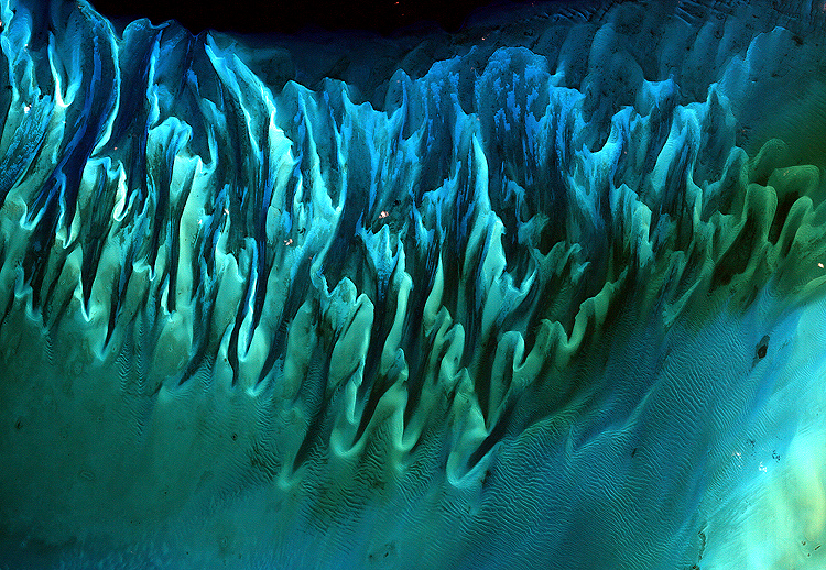
NASA image acquired January 17, 2001 Though the above image may resemble a new age painting straight out of an art gallery in Venice Beach, California, it is in fact a satellite image of the sands and seaweed in the Bahamas. The image was taken by the Enhanced Thematic Mapper plus (ETM+) instrument aboard the Landsat 7 satellite. Tides and ocean currents in the Bahamas sculpted the sand and seaweed beds into these multicolored, fluted patterns in much the same way that winds sculpted the vast sand dunes in the Sahara Desert. Image courtesy Serge Andrefouet, University of South Florida Instrument: Landsat 7 - ETM+ Credit: NASA/GSFC/Landsat NASA Goddard Space Flight Center enables NASA’s mission through four scientific endeavors: Earth Science, Heliophysics, Solar System Exploration, and Astrophysics. Goddard plays a leading role in NASA’s accomplishments by contributing compelling scientific knowledge to advance the Agency’s mission. Follow us on Twitter Join us on Facebook
- X
https://www.nasa.gov/image-detail/amf-gsfc_20171208_archive_e001879/
TakenApril 20, 2011
ProducerGSFC
Size750x518px
PIA NumberGSFC_20171208_Archive_e001879
