


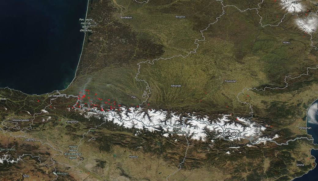
NOAA/NASA’s Suomi NPP satellite captured this image of fires across the Spain-France border near the Pyrenees Mountains. Grayish-white smoke drifts away from the fire areas toward the northwest. The problem with the image is that wildfires in this area at this time of year are quite unusual according to the Copernicus Emergency Management System’s (EMS) website which tracks fire activity across Europe. The site referenced authorized “stubble-burnings” which may have gotten out of control due to high winds. To illustrate how unusual this kind of fire activity is a comparison between 2018 and 2019 shows that only 360 ha (889 acres) on average is usually burned in this area from Jan 1 – Feb. 22. 2019 shows a dramatic increase to 17,465 ha (43,157 acres) burned to date. That is an increase of a factor of 48.5. Certainly climate change is aiding in this increase since higher temperatures lead to plants and trees releasing more moisture which leads to drier forests overall, so that a spark can lead to an inferno in no time. High winds also contribute to the spread of fire. Time will tell if this is an anomaly or this is the future going forward of forest fires in this area.
NASA’s Earth Observing System Data and Information System (EOSDIS) Worldview application provides the capability to interactively browse over 700 global, full-resolution satellite imagery layers and then download the underlying data. Many of the available imagery layers are updated within three hours of observation, essentially showing the entire Earth as it looks “right now.” NASA’s Suomi NPP satellite collected this natural-color image using the VIIRS (Visible Infrared Imaging Radiometer Suite) instrument on February 21, 2019. Actively burning areas, detected by MODIS’s thermal bands, are outlined in red. Image Courtesy: NASA Worldview, Earth Observing System Data and Information System (EOSDIS). Caption: Lynn Jenner with information from the Copernicus EMS site and fire news feed on that site.