


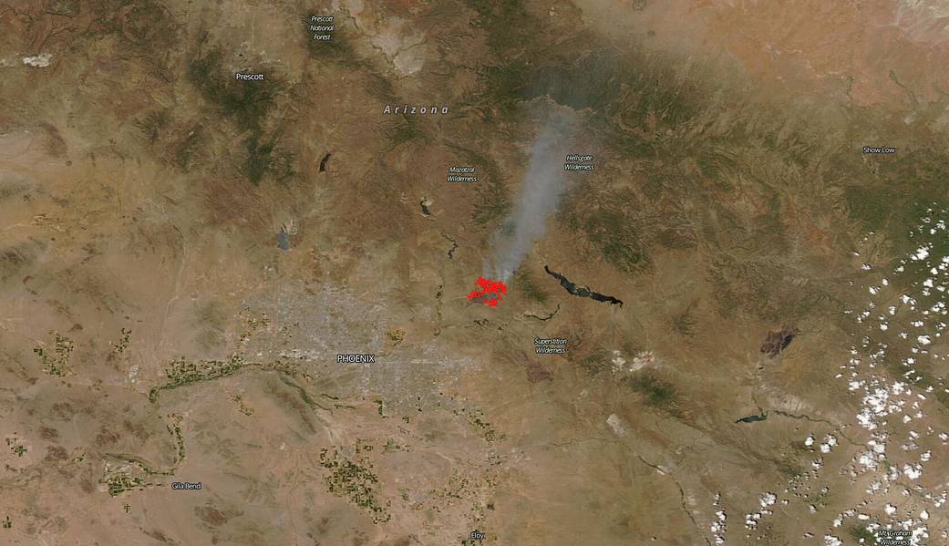
NASA’s Aqua satellite captured an image of the Bush Fire which began on Saturday, June 13 at 2:00 pm (MDT) within the Tonto National Forest into the Four Peaks Wilderness in Arizona. The Aqua image was captured by the MODIS (Moderate Resolution Imaging Spectroradiometer) instrument on June 14, 2020. As of June 15, 2020, the fire has burned 14,371 acres and is at 0% containment. The fire growth is being caused by hot, dry, windy conditions as well as an abundance of fuel including tall grass and brush. Officials in the area have put some nearby communities on notice that they are in pre-evacuation status.
Weather forecasts for the impacted area continue to be hot, dry and windy. Inciweb reports on June 15, 2020, that: “Resources on the fire include 11 engines, 3 hotshot crews, 2 helicopters, and 1 air attack. Multiple airtankers are available as needed. Firefighters and air support will continue to focus on building containment lines. No structures have been damaged. Infrastructure protection for State Highway 87, powerlines, private property, and sensitive recreation and heritage resources continue to be priorities for firefighting efforts. Smoke will continue to be seen in the east Phoenix metropolitan valley, with heavy smoke impacting the Tonto Basin and Roosevelt Lake areas, along with recreation sites along the lower Salt River.”
NASA’s satellite instruments are often the first to detect wildfires burning in remote regions, and the locations of new fires are sent directly to land managers worldwide within hours of the satellite overpass. Together, NASA instruments detect actively burning fires, track the transport of smoke from fires, provide information for fire management, and map the extent of changes to ecosystems, based on the extent and severity of burn scars. NASA has a fleet of Earth-observing instruments, many of which contribute to our understanding of fire in the Earth system. Satellites in orbit around the poles provide observations of the entire planet several times per day, whereas satellites in a geostationary orbit provide coarse-resolution imagery of fires, smoke and clouds every five to 15 minutes. For more information visit: https://www.nasa.gov/mission_pages/fires/main/missions/index.html
NASA’s Earth Observing System Data and Information System (EOSDIS) Worldview application provides the capability to interactively browse over 700 global, full-resolution satellite imagery layers and then download the underlying data. Many of the available imagery layers are updated within three hours of observation, essentially showing the entire Earth as it looks “right now.” This satellite image was collected by the Aqua satellite on June 14, 2020. Actively burning fires, detected by thermal bands, are shown as red points. Image Courtesy: NASA Worldview, Earth Observing System Data and Information System (EOSDIS). Caption: Lynn Jenner with information from Inciweb.