


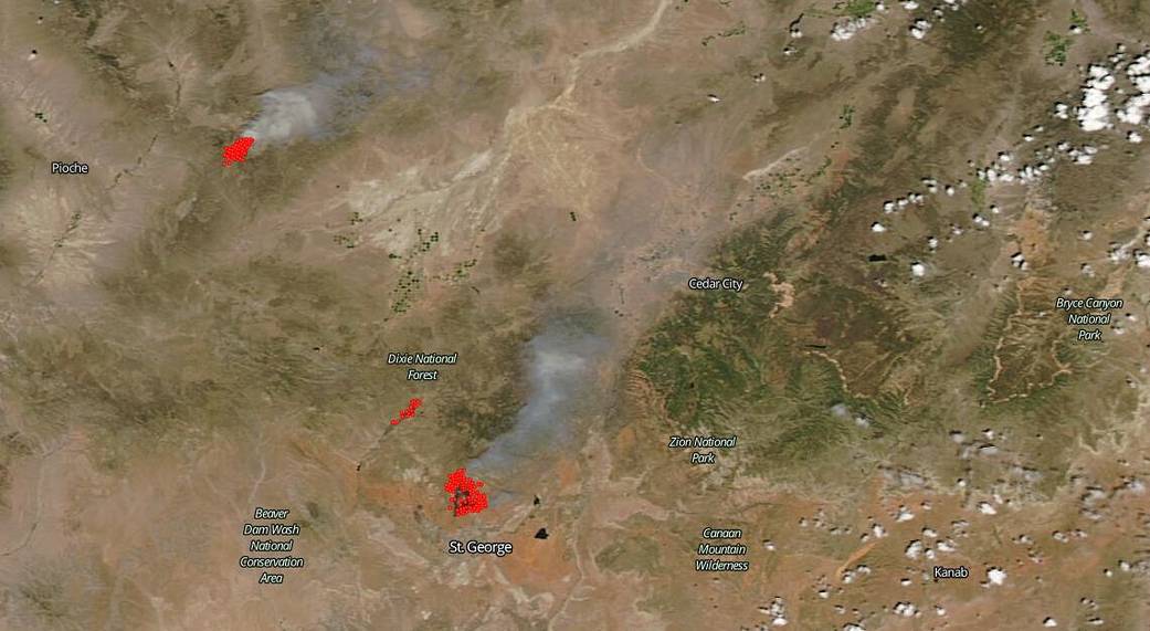
NASA’s Aqua satellite took this image of several fires in Utah, including one on the border with Nevada, by using the MODIS (Moderate Resolution Imaging Spectroradiometer) instrument on July 14, 2020. The fire on the border of Utah and Nevada is the Big Summit fire. The fire located just north of St. George in Utah is the Turkey Farm Road fire, and the smallest fire just northwest of the Turkey Farm Road fire, located in the Dixie National Forest is the Veyo West fire.
The Big Summit fire is located 17 miles northeast of Panaca, Nevada, and the cause of the fire is under investigation. This fire which began on July 13, 2020, has grown to 4,000 acres and is 10 percent contained. The fuels burning in this fire are timber, brush, and short grass. The weather forecast is not favorable for firefighters. Firefighters expect red flag conditions with high winds, low humidity, and extreme heat.
The Turkey Farm Road fire began late on July 13, 2020 and the cause of this fire was illegal use of fireworks which sparked a blaze in the dry conditions that the area is experiencing. More than 11,000 acres have burned and there is no containment of the fire as yet. There are no evacuations for this fire and one outbuilding has been destroyed. Local weather forecasts call for extreme heat (105+ degrees Fahrenheit) for the next several days, winds to 14 mph, low humidity, and no precipitation in the area. This forecast encompasses the Veyo West fire, discussed below, as well. Red flag warnings are in effect for both the Turkey Farm Road fire and the Veyo West fire below.
The Veyo West fire located just west of the Turkey Farm Road fire and one mile west of Veyo, Utah, began on July 13, 2020, and it is reported that it might have been caused by an improperly extinguished campfire, however, investigations are continuing into its origin. The fire has grown to 2,900 acres and is not contained at present.
NASA’s satellite instruments are often the first to detect wildfires burning in remote regions, and the locations of new fires are sent directly to land managers worldwide within hours of the satellite overpass. Together, NASA instruments detect actively burning fires, track the transport of smoke from fires, provide information for fire management, and map the extent of changes to ecosystems, based on the extent and severity of burn scars. NASA has a fleet of Earth-observing instruments, many of which contribute to our understanding of fire in the Earth system. Satellites in orbit around the poles provide observations of the entire planet several times per day, whereas satellites in a geostationary orbit provide coarse-resolution imagery of fires, smoke and clouds every five to 15 minutes. For more information visit: https://www.nasa.gov/mission_pages/fires/main/missions/index.html
NASA’s Earth Observing System Data and Information System (EOSDIS) Worldview application provides the capability to interactively browse over 700 global, full-resolution satellite imagery layers and then download the underlying data. Many of the available imagery layers are updated within three hours of observation, essentially showing the entire Earth as it looks “right now.” Actively burning fires, detected by thermal bands, are shown as red points. Image Courtesy: NASA Worldview, Earth Observing System Data and Information System (EOSDIS). Caption: Lynn Jenner with information from Inciweb and Utah Wildfire Info.