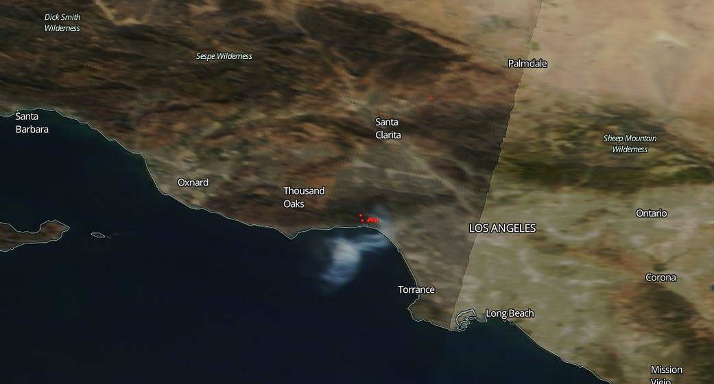
On October 21, 2019, a one-acre brush fire near the Pacific Palisades area outside of Los Angeles, Calif. broke out and quickly grew to 40 acres. NASA’s Aqua satellite provided an image that showed smoke from the fire and identified hot spots. According to the Los Angeles Fire Department facebook page, that quick growth prompted swift evacuations by fire officials due to the threat to homes in the area. Authorities urged residents of close to 200 homes to leave as flames came dangerously close to the residential area. Winds were light when the fire broke out on Oct. 21, 2019 which helped to keep the fire in check and also reduced the amount of embers blowing to other structures. Helicopters dropped water on the flames to keep the fire from advancing which served to quell the fire within the hour with no injuries or serious property damage reported. By 8:00 pm that night Los Angeles Fire Department reported that evacuation orders had been lifted. Firefighters also worked through the night to ensure that containment lines held and smoldering hot spots were controlled. It should be noted that the strong Santa Ana winds are to return to Southern California this Thursday, Oct. 24.
This natural-color NASA Aqua satellite image of the remnants of the fire was captured on Oct. 22, 2019 using the Moderate Resolution Imaging Spectroradiometer (MODIS) instrument. Actively burning areas, detected by MODIS’s thermal bands, are outlined in red.
NASA’s satellite instruments are often the first to detect wildfires burning in remote regions, and the locations of new fires are sent directly to land managers worldwide within hours of the satellite overpass. Together, NASA instruments detect actively burning fires, track the transport of smoke from fires, provide information for fire management, and map the extent of changes to ecosystems, based on the extent and severity of burn scars. NASA has a fleet of Earth-observing instruments, many of which contribute to our understanding of fire in the Earth system. Satellites in orbit around the poles provide observations of the entire planet several times per day, whereas satellites in a geostationary orbit provide coarse-resolution imagery of fires, smoke and clouds every five to 15 minutes. For more information: https://www.nasa.gov/mission_pages/fires/main/missions/index.html
Image credit: NASA’s Earth Observing System Data and Information System (EOSDIS) Worldview application provides the capability to interactively browse over 700 global, full-resolution satellite imagery layers and then download the underlying data. Many of the available imagery layers are updated within three hours of observation, essentially showing the entire Earth as it looks “right now.” Caption: Lynn Jenner with information from the Los Angeles Fire Department Facebook page


