


Satellite Sees Tropical Depression Greg as a Ghostly Swirl of Clouds
Tropical Depression Greg appears as a ghostly swirl of low clouds on satellite imagery from NOAA’s GOES-West satellite on July 27.
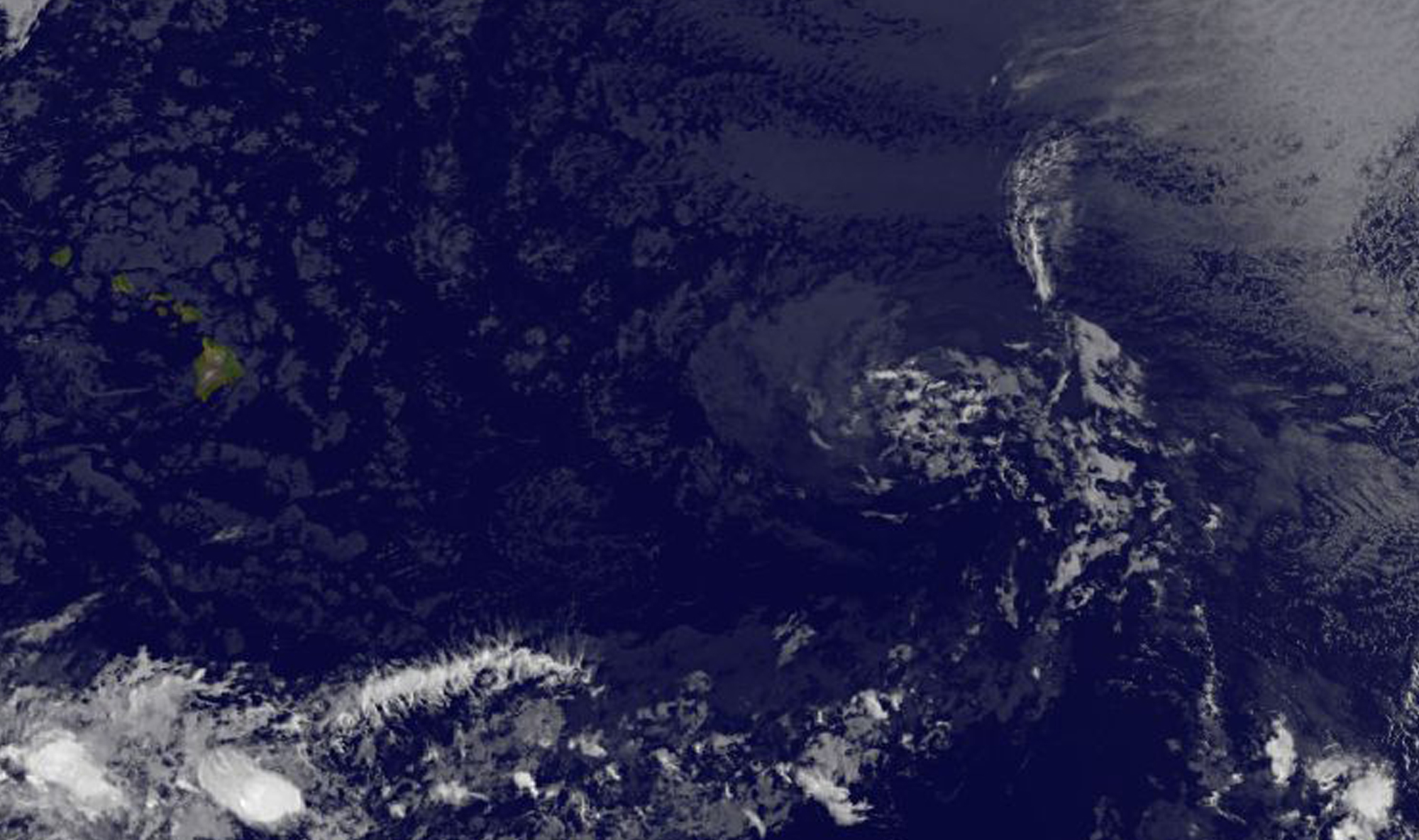
NOAA’s GOES-West satellite captured an infrared image of Greg on July 26 at 11 a.m. EDT (1500 UTC). The image showed that Greg’s circulation consists of a tight swirl of low clouds with a few small patches of deep convection. Strong vertical wind shear is affecting Greg now, pushing the clouds away from the center of circulation.
The National Hurricane Center (NHC) noted at 11 a.m. EDT (1500 UTC), the center of Tropical Depression Greg was located near 18.1 degrees north latitude and 141.0 degrees west longitude. It was about 965 miles (1,550 km) east of South Point, Hawaii.
The depression was moving toward the west near 12 mph (19 kph), and this motion is expected to continue today and Thursday, July 27. Maximum sustained winds are near 30 mph (45 kph) with higher gusts.
Greg is forecast to become a remnant low later today.
By Rob Gutro
NASA’s Goddard Space Flight Center
July 25, 2017 – Satellite Shows Tropical Storm Greg Being Affected by Wind Shear
NOAA’s GOES-East satellite provided an infrared look at a disorganized Tropical Storm Greg as it continues to weaken and get battered by wind shear in the Eastern Pacific Ocean.
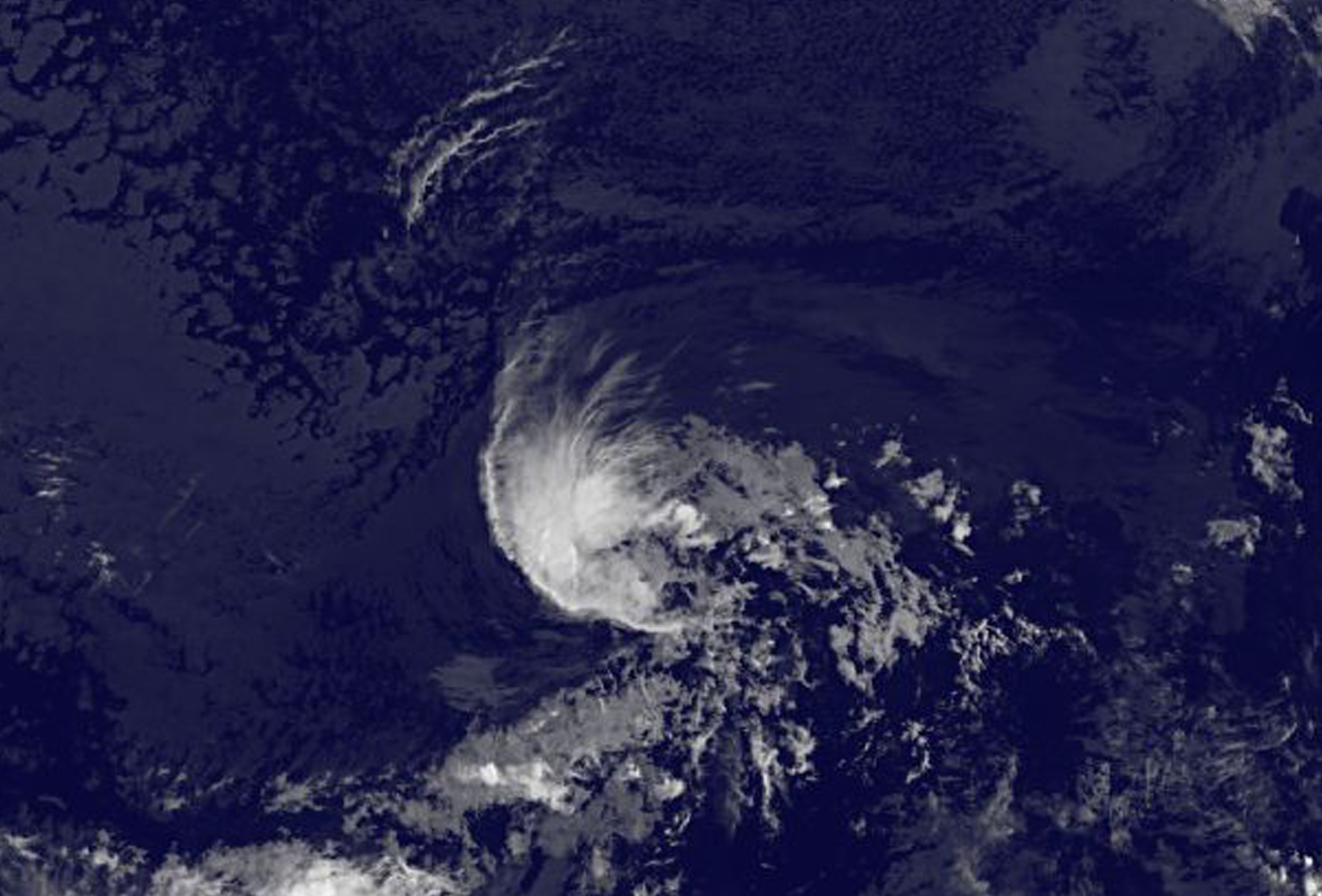
On July 25 at 8 a.m. EDT (1200 UTC) NOAA’s GOES-East satellite provided an infrared image of Tropical Storm Greg and showed that wind shear was affecting the storm. The National Hurricane Center (NHC) said that convection associated with Greg is currently very disorganized and confined to the northwestern quadrant. Southwesterly vertical winds were pushing the storms and clouds to the northwest of the center.
At 5 a.m. EDT (0900 UTC), the center of Tropical Storm Greg was located near 15.2 degrees north latitude and 135.7 degrees west longitude. That’s about 1,345 miles (2,165 km) east of South Point, Hawaii. Greg was moving toward the west-northwest near 9 mph (15 kph) and NHC forecasters expect a turn toward the northwest later today, followed by a gradual turn toward the west by Wednesday night.
Maximum sustained winds are near 45 mph (75 kph) with higher gusts. The estimated minimum central pressure is 1003 millibars. Some weakening is forecast during the next two days.
The National Hurricane Center noted that Greg is forecast to move into a drier air mass, encounter increasing vertical wind shear, and move over decreasing sea surface temperatures during the next two to three days. That combination should result in the system degenerating to a remnant low pressure area.
For updates and forecasts, visit the NHC website: www.nhc.noaa.gov
By Rob Gutro
NASA’s Goddard Space Flight Center
July 24, 2017 – Satellite Shows Tropical Storm Greg Losing Shape
Tropical Storm Greg appears to be less-rounded and more elongated on satellite imagery from NOAA’s GOES-West satellite. Greg is still over 1,500 miles east of Hawaii.
NOAA’s GOES-West satellite captured an infrared image of Tropical Storm Greg on July 24 at 8 a.m. EDT (1200 UTC). The image revealed a less-rounded tropical cyclone. The National Hurricane Center noted the reason for the change in shape: “Greg’s convective structure is gradually deteriorating, likely due to very dry air in the surrounding atmosphere.”
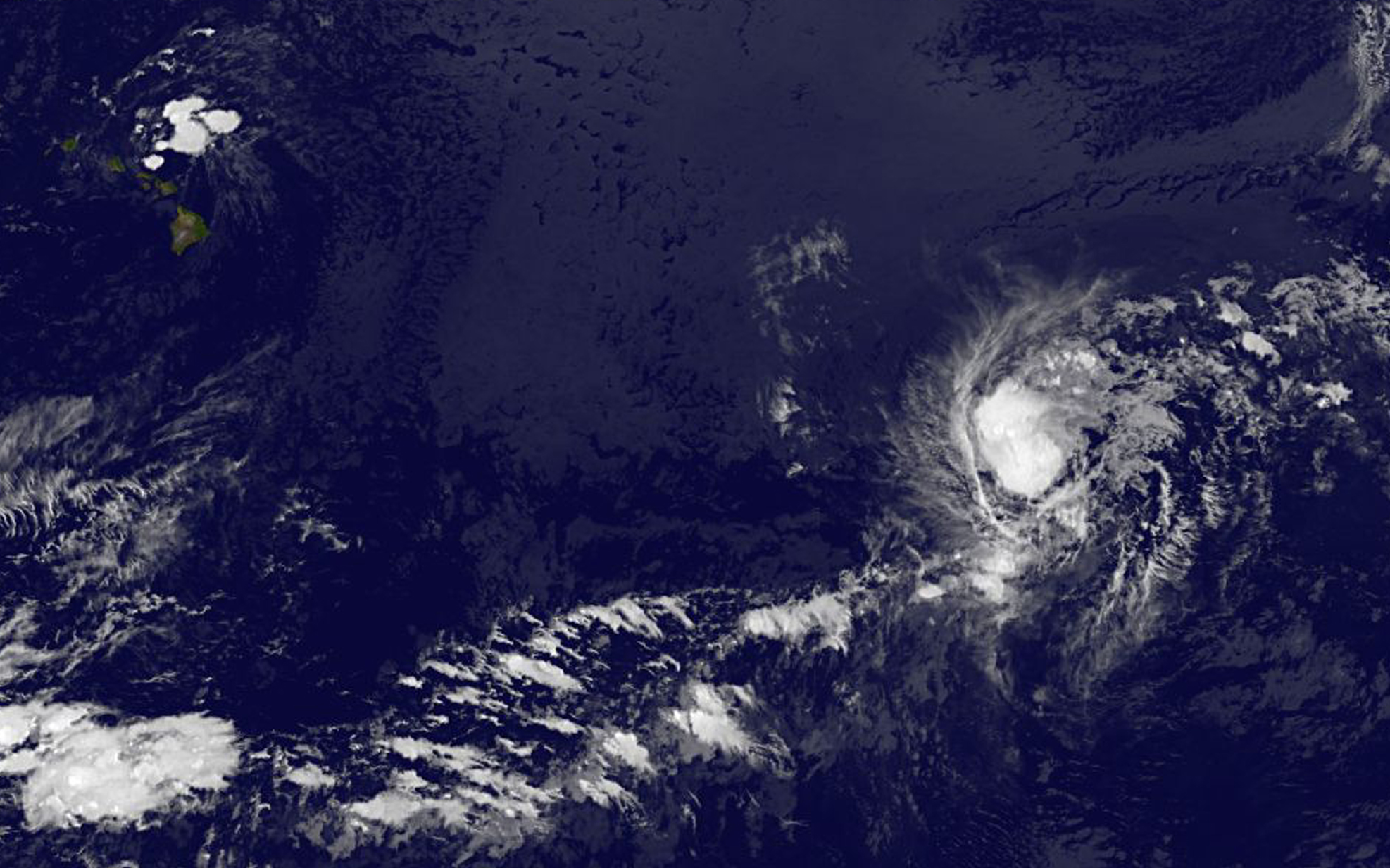
NOAA manages the GOES series of satellites, and NASA uses the satellite data to create images and animations. The image was created by the NASA/NOAA GOES Project at NASA’s Goddard Space Flight Center in Greenbelt, Maryland.
At 11 a.m. EDT (1500 UTC), the center of Tropical Storm Greg was located near 14.6 degrees north latitude and 133.2 degrees west longitude. That’s about 1,515 miles (2,440 km) east of South Point Hawaii. Greg was moving toward the west near 12 mph (19 kph). A west-northwestward or northwestward motion at a slower forward speed is expected during the next couple of days.
Maximum sustained winds are near 45 mph (75 kph) with higher gusts. Weakening is forecast during the next 48 hours. Greg will likely be a tropical depression by about July 26 and then a remnant low by July 27.
For updated forecasts, visit: www.nhc.noaa.gov.
By Rob Gutro
NASA’s Goddard Space Flight Center
July 21, 2017 – Satellite Sees Tropical Storm Greg After ‘Eating’ a Depression
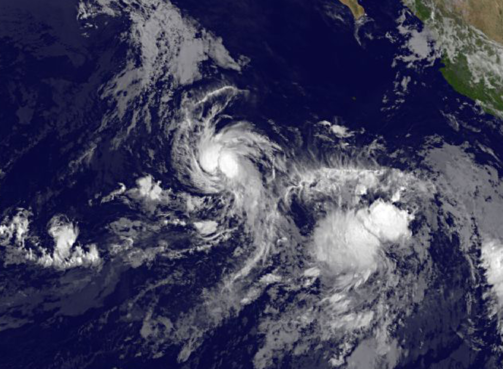
Tropical Storm Greg is intensifying after absorbing the moisture from the remnants of former Tropical Depression 8E. NOAA’s GOES-West satellite captured an image of Greg as it moves west in the Eastern Pacific.
NOAA’s GOES-West satellite captured an infrared image of Greg on Friday, July 21, 2017 at 8 a.m. EDT (1200 UTC). The image showed two large areas of convection in Greg with a band of thunderstorms spiraling into the low-level center from the north and south. Located to the southeast of Greg are an amorphous area of clouds from the remnants of Tropical Depression 8E.
The National Hurricane Center (NHC) issued an advisory on the storm at 11 a.m. EDT (1500 UTC) and noted that the center of Tropical Storm Greg was located near 15.1 degrees north latitude and 119.2 degrees west longitude. That’s about 810 miles (1,305 km) southwest of the southern tip of Baja California, Mexico.
Greg was moving toward the west-northwest near 10 mph (17 kph) and NHC expects a continued westward to west-northwestward motion with a slight increase in forward speed through the weekend. Maximum sustained winds have increased to near 60 mph (95 kph) and Greg is forecast to become a hurricane by Sunday, July 23.
By Rob Gutro
NASA’s Goddard Space Flight Center, Greenbelt, Md.
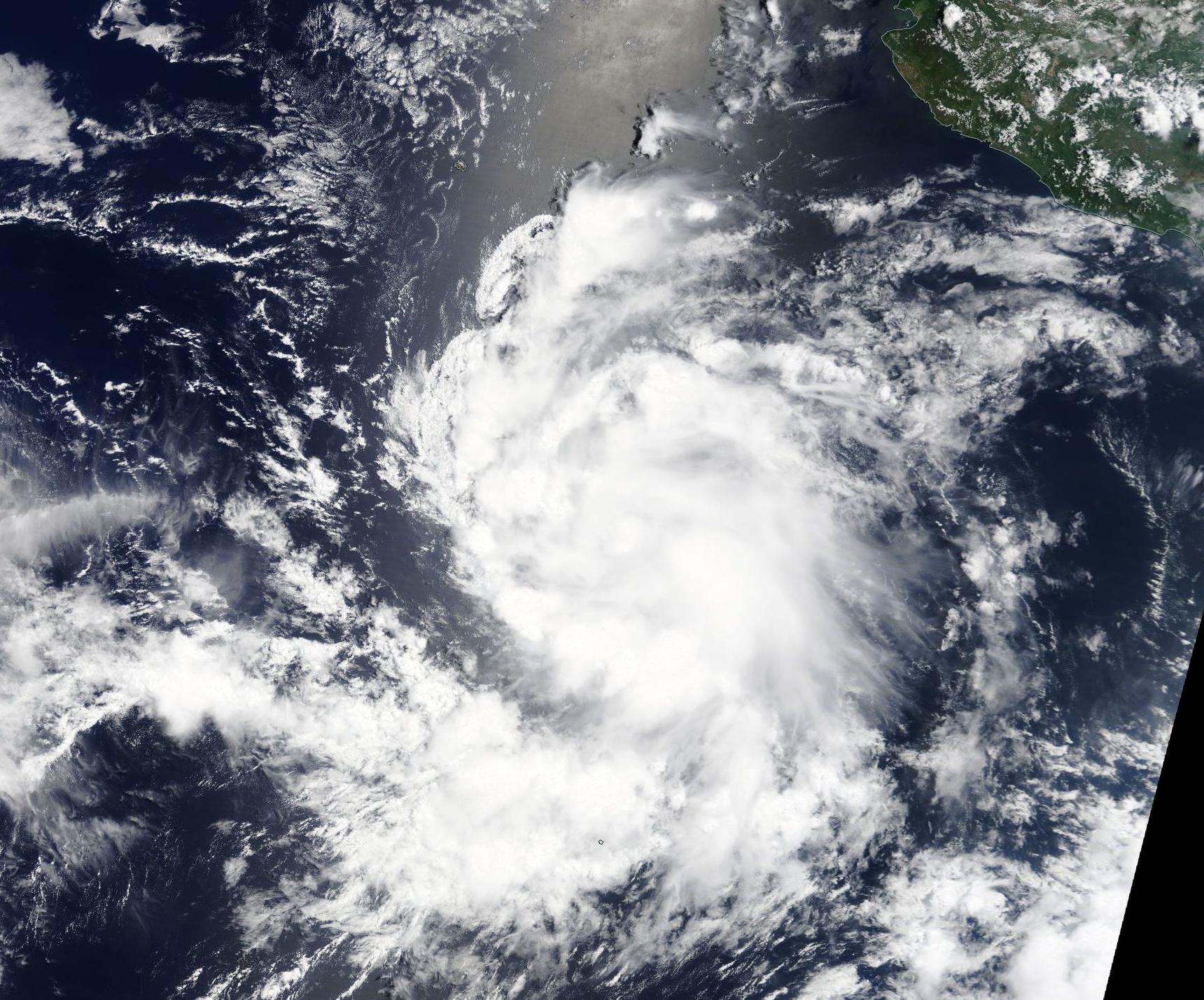
July 19, 2017 – NASA’s Terra Satellite Watching Tropical Storm Greg
NASA Terra satellite provided a clear view of Tropical Storm Greg, located off the southwestern coast of Mexico. Greg is one of three tropical cyclones in the Eastern Pacific Ocean and is the closest to land.
On July 18 at 4:30 p.m. EDT (2030 UTC) the Moderate Resolution Imaging Spectroradiometer or MODIS instrument aboard NASA’s Terra satellite captured visible-light image of Tropical Storm Greg. The image showed powerful, high thunderstorms surrounding the center of circulation and bands of thunderstorms wrapping into the low-level center from the north and south. At the time, Greg’s maximum sustained winds were near 40 mph (65 kph) and it was strengthening. Greg peaked in intensity by 11 p.m. EDT that day when its maximum sustained winds reached 50 mph (85 kph).
On July 19 at 5 a.m. EDT (0900 UTC), NOAA’s National Hurricane Center (NHC) noted that Greg had weakened, but that’s only temporary. Maximum sustained winds were near 45 mph (75 kph) with higher gusts. The NHC said that gradual strengthening is forecast during the next 48 hours. The estimated minimum central pressure is 1,005 millibars.
The center of Tropical Storm Greg was located near 14.3 degrees north latitude and 111.0 degrees west longitude. That’s about 550 miles (885 km) southwest of Manzanillo, Mexico. Greg lies to the west of struggling Tropical Depression 8E and is preventing that depression from strengthening.
Greg was moving toward the west near 10 mph (17 kph) and NHC expects a turn toward the west-northwest with an increase in forward speed by Thursday.
For updated forecasts on Eugene, visit: www.nhc.noaa.gov.
By Rob Gutro
NASA’s Goddard Space Flight Center, Greenbelt, Md.
July 18, 2017 – NASA Sees Tropical Storm Greg Come Together
The Eastern Pacific Ocean’s sixth tropical storm developed from an area of low pressure south of the coast of Mexico. NASA’s Aqua satellite analyzed cloud top temperatures and found some powerful thunderstorms in the new tropical cyclone.
On July 17 at 11 a.m. EDT Tropical Depression 7E formed about 340 miles (550 km) south of Manzanillo, Mexico. By July 18 at 5 a.m. EDT the depression had strengthened into a tropical storm and was renamed Greg.
The center of Tropical Storm Greg was located near 14.6 degrees north latitude and 107.6 degrees west longitude. That’s about 375 miles (600 km) south of Manzanillo, Mexico. Greg was moving toward the west-northwest near 9 mph (15 kph). Maximum sustained winds are near 40 mph (65 kph) with higher gusts. The northwesterly shear currently affecting Greg is expected to gradually lessen over the next couple of days, so some strengthening is forecast during the next couple of days.
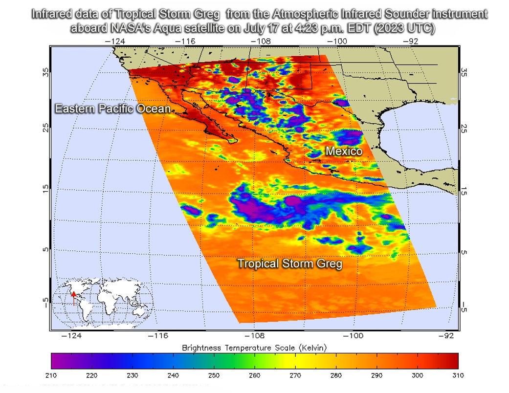
On July 17 at 4:23 p.m. EDT (2023 UTC) the Atmospheric Infrared Sounder instrument aboard NASA’s Aqua satellite provided infrared temperature data on Tropical Storm Greg’s clouds. The data showed cloud top temperatures were near 230 kelvin (minus 45.6 degrees Fahrenheit / minus 43.1 degrees Celsius) in thunderstorms circling the low-level center of circulation and in a large band extending west of the center.
The National Hurricane Center expects Greg to move in a westward to west-northwestward motion with a slight increase in forward speed during the next 48 hours. On the forecast track, the cyclone is expected to move away from southern Mexico.
The NHC discussion noted that the depression will likely degenerate to a remnant low pressure area in 4 to 5 days when it moves over sea surface temperatures below the 80 degree Fahrenheit (26.6 degree Celsius) threshold needed to maintain tropical cyclones.
For updated forecasts, visit: www.nhc.noaa.gov
By Rob Gutro
NASA’s Goddard Space Flight Center, Greenbelt, Md.