


In November 1962, NASA approved the Mariner Mars 1964 Project to send two spacecraft to fly by Mars and take photographs and make other measurements during the encounter. The Jet Propulsion Laboratory in Pasadena, California, managed the project, building on its experience with the Mariner 2 encounter with Venus in December 1962. Each spacecraft weighed 575 pounds and carried seven science instruments:
- The television imaging system enabled topographic reconnaissance of the Martian surface.
- The Helium Magnetometer measured magnetic field strength around the planet.
- The Ionization Chamber and particle flux detector measured the omnidirectional flux of particle radiation near Mars and in interplanetary space.
- The Cosmic Dust Detector measured dust particle momentum and mass distribution.
- The Cosmic Ray Telescope measured charged particles.
- The Trapped Radiation Detector consisted of three Geiger-Muller detectors to measure any charged particles that may be trapped by a Martian magnetic field.
- The Solar Plasma Probe measured the density, velocity, temperature, and direction of movement of protons streaming from the Sun.
Four solar panels generated 310 watts of electric power to operate the spacecraft’s systems and science instruments. During the eight-month cruise phase to Mars, the spacecraft took measurements on the conditions of interplanetary space and transmit the data to Earth. During the flyby of the planet, the spacecraft recorded the images onboard for playback to Earth after the encounter.
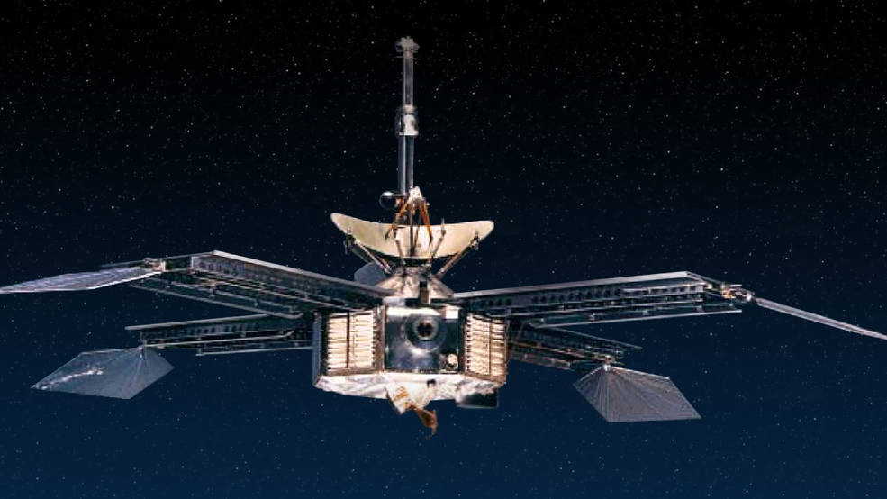
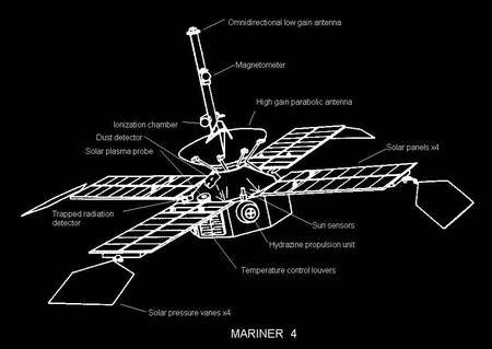
Left: Photograph of the Mariner 3 and 4 spacecraft.
Right: Schematic of the Mariner 4 spacecraft indicating the science instruments.
The first of the two spacecraft, Mariner 3, launched from Cape Kennedy, Florida, on Nov. 5, 1964, atop an Atlas-Agena D rocket. The initial phases of the launch proceeded normally, but the fiberglass payload shroud protecting the spacecraft during the ascent through the atmosphere failed to separate. The spacecraft’s solar panels could not deploy and the onboard batteries depleted after 8 hours and 43 minutes. Mariner 3 sailed on into solar orbit as an inert spacecraft. An investigation pinpointed the cause of the failure and engineers quickly redesigned, fabricated, and tested a new all-metal shroud. The second spacecraft, Mariner 4, successfully launched on Nov. 28, just two days before the close of the launch window, and the new shroud worked as designed. Had the spacecraft remained on its initial trajectory it would have missed Mars by about 155,000 miles, but a course correction on Dec. 5 reduced the flyby distance.
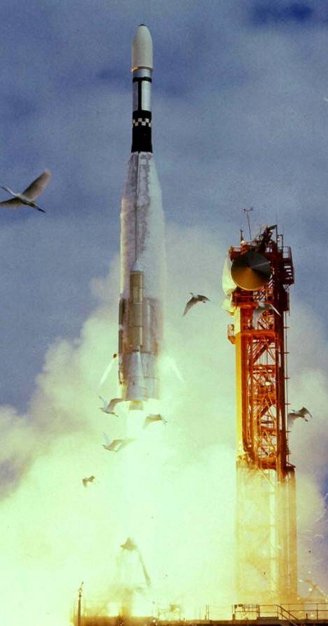
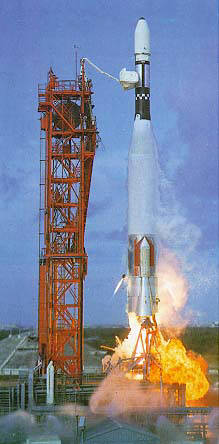
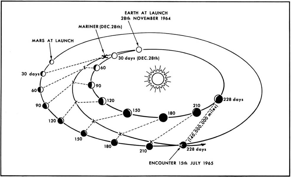
Left: Launch of Mariner 3. Middle: Launch of Mariner 4. Right: Trajectory of Mariner 4 to Mars.
On July 14, 1965, after a 228-day cruise from Earth, Mariner 4 passed within 6,118 miles of Mars, snapping 22 photographs of the planet and taking scientific measurements. The spacecraft passed behind the planet as seen from Earth, allowing a radio occultation study to estimate the density of the Martian atmosphere. Playback of the flyby imagery began soon after Mariner 4 emerged from behind Mars and continued until Aug. 3.
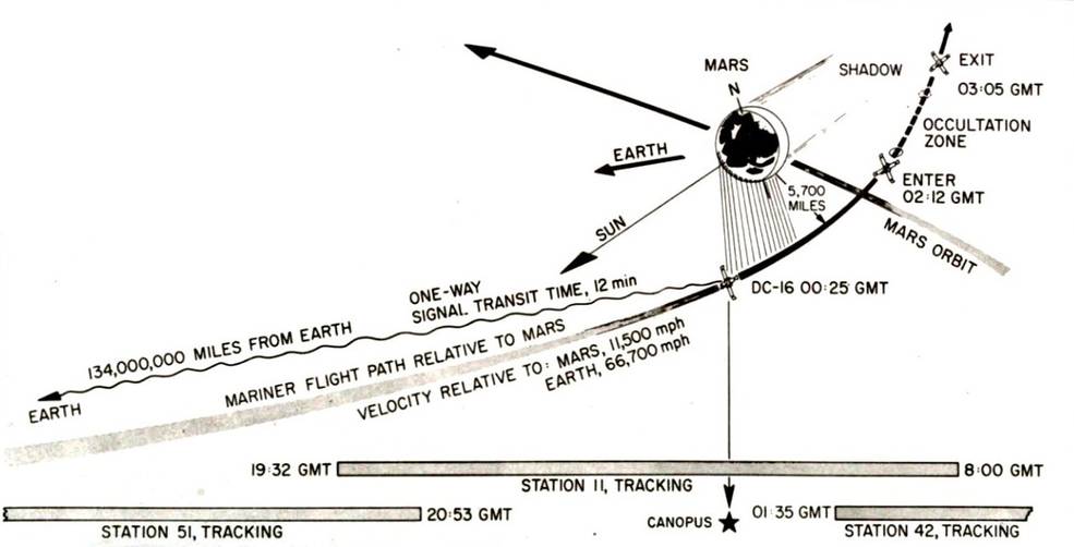
Schematic representation of Mariner 4’s flyby of Mars.
The data Mariner 4 beamed back to Earth surprised many scientists. The radio occultation results indicated a very low surface atmospheric pressure, about 1 % that at Earth’s sea level. Scientists estimated the surface temperature at about -100o C and the spacecraft detected no magnetic field or trapped radiation belts around the planet. The photographs revealed a cratered surface resembling the Moon, although the photographs covered less than 1 % of the Martian surface and did not represent Mars as we know it today. All in all, these findings dashed many scientists’ expectations of Mars as a place hospitable to life.
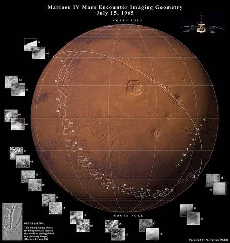
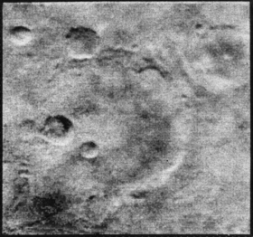
Left: Global image of Mars indicating the areas imaged by Mariner 4. Right: The clearest of the Mariner 4 photographs taken from a distance of 7,830 miles showing a cratered surface.