


NASA’s mission to pioneer the future in space exploration, scientific discovery, and aeronautics research necessitates the proactive development and implementation of a number of GPS applications, to enable greater spacecraft autonomy and more advanced space science and Earth monitoring applications.
Space Communication
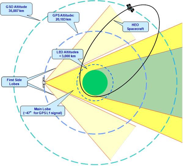
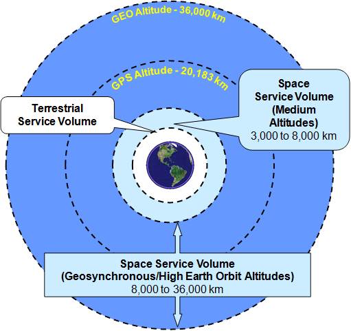
NASA users in orbit can determine their position and time using communications channel tracking via the Deep Space Network (DSN), Near Space Network (NSN), or by on-board means of processing one-way radio-navigation signals from Global Navigation Satellite Systems (GNSS), such as the US Global Positioning System (GPS). The DSN is also capable of supporting tracking from Low Earth Orbit (LEO) through interplanetary transfer domains. While NASA missions primarily use communication channel tracking by the DSN and NSN for trajectory analysis, individual missions may choose to also use GPS measurements as an observable or backup out to Geosynchronous Orbit (GEO – 36,000 Km) as acceptance of GPS for a positioning source becomes more widespread.
Autonomy of Spacecraft Operations
GPS, and other GNSS systems such as the Russian GLONASS constellation, may be used to enable more on-board autonomous navigation. GPS-based navigation uses one-way signals from GPS satellites to determine the spacecraft’s trajectory through its on-board instruments and data processing. GPS currently provides real-time on-board three dimensional position and time with a 95% accuracy of approximately 10 meters horizontally and 20 meters vertically per performance standards, however in reality the actual mission performance can be much better depending on the scenario or application. GPS may also provide accurate time synchronization and attitude determination (in lieu of other sensors, such as star trackers). The actual User Ranger Error (URE) on a global average has been demonstrated to be as precise as one meter or better in recent years.
GPS and Science Applications
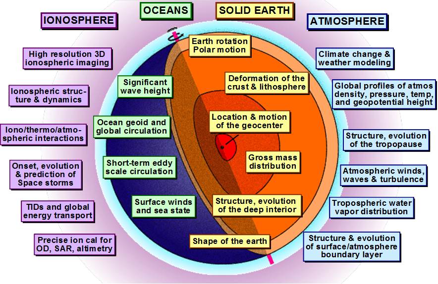
SCaN and NASA’s Science Mission Directorate (SMD) are partnering to improve the performance of the GPS constellation through policy advocacy for modernization improvements via the GPS requirements process, the National Space-based PNT Executive Committee, and the National Space-based PNT Advisory Board. One example is NASA leadership of an interagency team working to place laser retro-reflectors on the next generation of GPS, known as GPS III. Enabling satellite laser ranging to GPS and other GNSS constellations allows for systematic errors in the radiometric data to be identified and corrected. This information could then be used to improve the Earth-centered terrestrial reference frame that GPS positioning is based on, leading to millimeter level accuracies. This would generate a terrific increase in performance and precision that would allow scientists the word over to do such things as measure climate change effects by monitoring ice melt or sea levels. SMD is planning to purchase the reflectors, while also continuing its funding to the International Laser Ranging System (ILRS), which is an international network of ground laser tracking stations. The primary mission of ILRS is to support geodetic and geophysical research.