


NASA AND NAVAL RESEARCH LAB STUDY COASTAL EDDIES
April 14, 2003
Release: 03-22
Printer Friendly Version
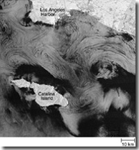
Swirling waters off southern California will be studied by NASA and the Naval Research Laboratory (NRL) this month. These coastal eddies can be important in bringing nutrients from deep to surface waters where they provide stimulus for ocean plant growth. Eddies can transport pollutants that originated on land, recirculating this material for several days. This may have both good and bad consequences for life in the ocean.
Scientists from NASA’s Jet Propulsion Laboratory and the Naval Research Laboratory, Washington, D.C., are interested in spiral-shaped slicks, or glassy water, on the ocean’s surface that may result from small-scale eddies in the ocean. Theories predict the spirals take several days to evolve. These eddies are generally between three and six miles in diameter.
NASA will fly its specially-instrumented airborne sciences DC-8 jet, based at the Dryden Flight Research Center, Edwards, Calif., over the Southern California Bight, the area between Point Conception and San Diego, to locate eddies using Airborne Synthetic Aperture Radar (AIRSAR).
During daily flights, the AIRSAR, designed and built by NASA’s Jet Propulsion Laboratory in Pasadena, Calif., will capture sequences of eddy images in rapid succession to enable researchers to measure the motion caused by currents. The DC-8 is vital to this project because it can be positioned with precision where needed over consecutive days.
“We can study the currents as they wind-up the ocean slicks into spiral patterns, and we can study the types of currents that either create or do not create eddies,” said George Marmorino, coastal eddies lead scientist for NRL.
Once a clear ocean eddy is detected from the DC-8, the position of the eddy will be relayed to oceanographers on the Sea World UCLA, a research vessel that can measure the deeper currents and density structure associated with the eddy. Additional satellite imagery will also help to identify eddy locations.
While such small-scale eddies are common in the global coastal seas, surprisingly little is known about these eddies. The eddies’ small size and transient nature have made it very difficult for ships to locate and measure their properties. Scientists hope the unique combination of the AIRSAR flights, ship measurements and satellite ocean sensors provide the best opportunity to understand the characteristics of these small but important coastal features. Collaborating in the study are the University of California, Los Angeles, departments of Civil and Environmental Engineering and Atmospheric Sciences and the Scripps Institution of Oceanography, University of California, San Diego.
For information about AIRSAR: http://airsar.jpl.nasa.gov the DC-8: /centers/dfrc/Research/ For information about ocean coastal eddies: http://airsea-www.nasa.gov/centers/jpl/cos/california/
-nasa-
Note to Editors: