


NASA’s Artemis Rover to Land Near Nobile Region of Moon’s South Pole
by Katie Cousins
Lee esta nota de prensa en español aquí.
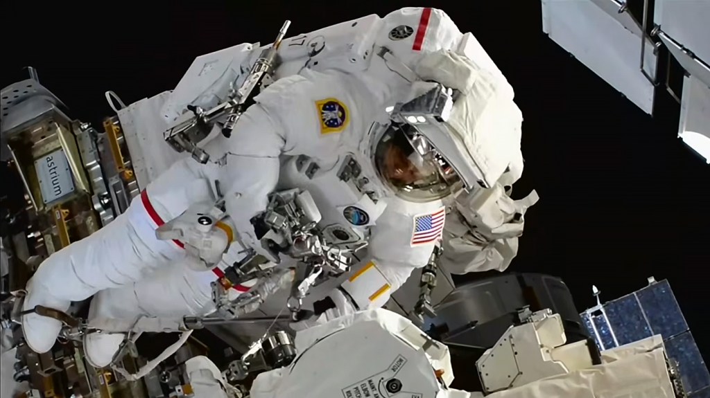
In 2023, NASA’s Volatiles Investigating Polar Exploration Rover (VIPER) will land near the western edge of the Nobile Crater at the Moon’s South Pole to map and explore the region’s surface and subsurface for water and other resources. Part of Artemis, VIPER will launch on a SpaceX Falcon-Heavy rocket for delivery to the Moon by Astrobotic’s Griffin lander under NASA’s Commercial Lunar Payload Services initiative.
The Moon’s South Pole is one of the coldest areas in our solar system. No prior missions to the Moon’s surface have explored it – scientists have thus far only studied the region using remote sensing instruments, including those on NASA’s Lunar Reconnaissance Orbiter and the Lunar Crater Observation and Sensing Satellite.
Data from these and other missions helped scientists conclude that ice and other potential resources exist in permanently shadowed areas of the Moon near the poles. After an extensive landing site selection process, the mountainous area west of Nobile Crater was chosen as VIPER’s landing site due to its rover-accessible terrain and array of nearby sites of scientific interest, including permanently shadowed areas.
“Once on the lunar surface, VIPER will provide ground truth measurements for the presence of water and other resources at the Moon’s South Pole, and the areas surrounding Nobile Crater showed the most promise in this scientific pursuit” said Thomas Zurbuchen, associate administrator for science at NASA Headquarters. “The data VIPER returns will provide lunar scientists around the world with further insight into our Moon’s cosmic origin, evolution, and history, and it will also help inform future Artemis missions to the Moon and beyond by enabling us to better understand the lunar environment in these previously unexplored areas hundreds of thousands of miles away.”
Nobile Crater is an impact crater that was formed through a collision with another smaller celestial body, and is almost permanently covered in shadows, allowing ice to exist there. Smaller, more accessible craters surrounding Nobile’s perimeter, will also provide VIPER with ideal locations to investigate in its search for ice and other resources.
“Selecting a landing site for VIPER is an exciting and important decision for all of us,” Daniel Andrews, VIPER project manager, said. “Years of study have gone into evaluating the polar region VIPER will explore. VIPER is going into uncharted territory—informed by science—to test hypotheses and reveal critical information for future human space exploration.”
Landing Site Selection
NASA’s team evaluated viable rover traverse paths, taking into account where VIPER could use its solar panels to charge and stay warm during its 100-day journey. The area near Nobile Crater provided a lot of flexibility.
VIPER’s currently planned trajectory allows the rover to visit at least six sites of scientific interest, with additional time to spare.
“Our evaluation of the landing site was driven by science priorities,” said Anthony Colaprete, VIPER lead project scientist at NASA’s Ames Research Center in Silicon Valley, California. “We seek answers to some pretty complex questions and studying these resources on the Moon that have stood the test of time will help us answer them.”
The VIPER team aims to address how frozen water and other resources arrived on the Moon in the first place. They also plan to identify where they came from, how they remained preserved for billions of years, how they escape, and where they go.
VIPER’s Journey Across the Nobile Region
The area VIPER will study in the Nobile region covers an approximate surface area of 36 square miles (93 square kilometers), 10 to 15 miles (16 to 24 km) of which VIPER is expected to traverse through during the course of its mission. During this time, the rover will visit carefully chosen areas of scientific interest that will provide further insight into a wide array of different kinds of lunar environments. The VIPER team will look to characterize ice and other resources in these areas using VIPER’s sensors and drill.
As VIPER moves among each area of scientific interest, it will collect samples from at least three drill locations. Analysis of these samples from a variety of depths and temperatures will help scientists to better predict where else ice may be present on the Moon based on similar terrain, allowing NASA to produce a global resource map. This map, and the other science VIPER will produce, will allow scientists to better understand the distribution of resources on the Moon and help inform future crewed missions to establish a long-term presence on the lunar surface.
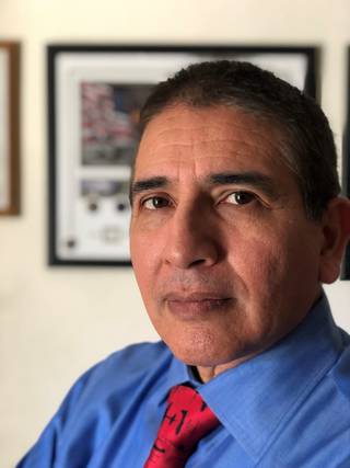
Donald Mendoza, Ph.D., Selected as the Lifetime Achievement Award Winner by Great Minds in STEM
by Maria C. Lopez
Dr. Donald (Don) Mendoza was selected by HENAAC Great Minds in STEM (GMiS) to receive the Lifetime Achievement Award in Government! Lifetime Achievement winners are individuals who are not executives; however, they have given 30 or more years of amazing service and commitment to STEM.
Mendoza’s journey to NASA is incredible and inspirational. He is the youngest of eight siblings and was born and raised on an isolated farm along California’s San Joaquin River. As a child, he started working in the crop fields at the age of six and did not leave this labor-intensive work, often performed seven days a week from sun rise to sundown in 110-degree heat, until he left for college.
Mendoza’s family loved and supported him. They worked long hours so he wouldn’t have to and most importantly, they encouraged him to do well in school. He was gratefully aware of his family’s efforts to pave a path for him that was different from their own. They were pointing him towards a path that led to a college education and a professional career. He was resolved to honor them by taking that path.
While toiling in the fields at the age of six, he often noticed the birds in the sky. He was captivated by the concept of flight. He saw the birds as free. He made up his mind to be a military pilot and an aeronautical engineer to help protect what he believed the American dream to be. He read books about airplanes and rockets so that he could build and experiment with his own creations. He discovered and cherished his role models: fighter/test pilot Chuck Yeager, engineering pioneers Theodore Von Karmen and Kelly Johnston, and astronaut Michael Collins, from the historic Apollo 11 crew.
In junior high school, Mendoza became very interested in science and realized he needed to develop a plan to reach his goals of earning a degree in aerospace engineering and becoming an Air Force pilot. To attain these goals, he invested any time he was not working in studying, experimenting with rockets, and reading about aerospace.
Outside of the farm and his hidden aspirations, he needed another outlet and a way to make friends; what came naturally was sports. He played sports of all kinds but favored football. Soon, most of his friends were fellow teammates. Mendoza was one of the few athletes at his high school taking college preparatory classes and successfully competing with students that concentrated on academics.
He decided that the California Polytechnic State University in San Luis Obispo (Cal Poly) was the ideal school to help him fulfill his dreams. Cal Poly was a fascinating place with its own airstrip and hanger as well as a rodeo arena on campus. It seemed a great place for a small-town farm boy to transition into the world of science and engineering. High school counselors and teachers told him that his goals were unrealistic. Nevertheless, he applied to and was accepted into Cal Poly. Although it was his dream to attend Cal Poly, he made the difficult decision to attend the local community college, so he could continue working on the farm to help his family. Mendoza earned a two-year engineering degree with honors and was re-accepted into Cal Poly, where he earned an aeronautical engineering degree with honors.
Just before agreeing to attend the Navy’s Aviation Officer Candidate School in Pensacola Florida to become a Weapons Systems Officer, he accepted a job with the company, Morton-Thiokol, that made the space shuttle solid rocket motor boosters. Weeks later the Challenger tragedy occurred, and he decided to accept a position with United States Air Force at the Flight Test Center (AFFTC) at Edwards Air Force Base in California instead. Here, Mendoza fulfilled some of his earliest dreams as he worked on and flew in F-15, T-38 and F-16 jets. Here, he also met one of his heroes, retired General Chuck Yeager, becoming further motivated to pursue his dreams. He also teamed up with past and future astronauts as a student at the USAF Test Pilot School and a member of a flight test squadron aimed at ensuring the nation maintained its air superiority over its adversaries.
During his time at the AFFTC, he made critical contributions towards protecting pilots from flaming out their engines during combat maneuvers, which were being explored for the air campaign in Operation Desert Storm. His findings were published in the F-15’s “dash-1” or flight manual and informed the pilots when they were at risk of suffering a flame out. Mendoza’s last assignment at the AFFTC was to ensure the YF-22 would meet the nation’s future air superiority requirements. With this mission complete, he turned his attention towards academia.
Mendoza left the AFFTC to attend graduate school at the University of California at Berkeley. The exposure to such a rich diversity of cultures and peoples at UC Berkeley combined with his upbringings to always respect and value people as individuals regardless of their gender, race, or color would serve him significantly in his future. Mendoza completed his Ph.D. with honors and has been with NASA Ames Research Center ever since.
During his career at Ames, Mendoza has held many positions and responsibilities including system safety and mission assurance engineer, systems engineer, Lessons Learned Committee Chairperson, Knowledge Management Officer, Risk Management Office, Mishap Review Board Chairperson, Quality Management System Manager, and Chief of the System Safety and Mission Assurance (SS&MA) Division. While his NASA career spans multiple decades, there is a common thread throughout his accomplishments in that they have all been in the service of others. He has authored many documents governing Ames’ work and was among the earliest to transition Ames towards a risk-based approach to optimize the effectiveness and efficiency of the workforce’s efforts. He has been recognized via various awards and commendations for his contributes to agency-level documents in systems engineering and the SS&MA domains.
Mendoza has been both an agent of change and a force multiplier during his career. His most recent efforts have contributed to Ames achieving, in SS&MA, what other institutions sometimes need double and triple the staff to achieve. He has accomplished this by valuing and championing employee empowerment, trust, and diversity. While building on his own history – which ran through the farmlands of the San Joaquin Valley, the nation’s breadbasket and landing place for many immigrants; the high desert of the Mojave, the gateway to the frontier of space; and the halls of UC Berkeley – he built one of Ames’ most diverse and inclusive technical organizations. Mendoza considers this to be his most significant accomplishment to date.
As Hispanic Heritage Month is Sept. 15 to Oct. 15, the Hispanic Advisory Committee for Employees, or HACE, is excited to feature Dr. Donald Mendoza and celebrates his family; his significant impact in aerospace research propelling the nation; and his commitment to diversity, equity, inclusion, and accessibility – opening doors for others and advancing NASA.
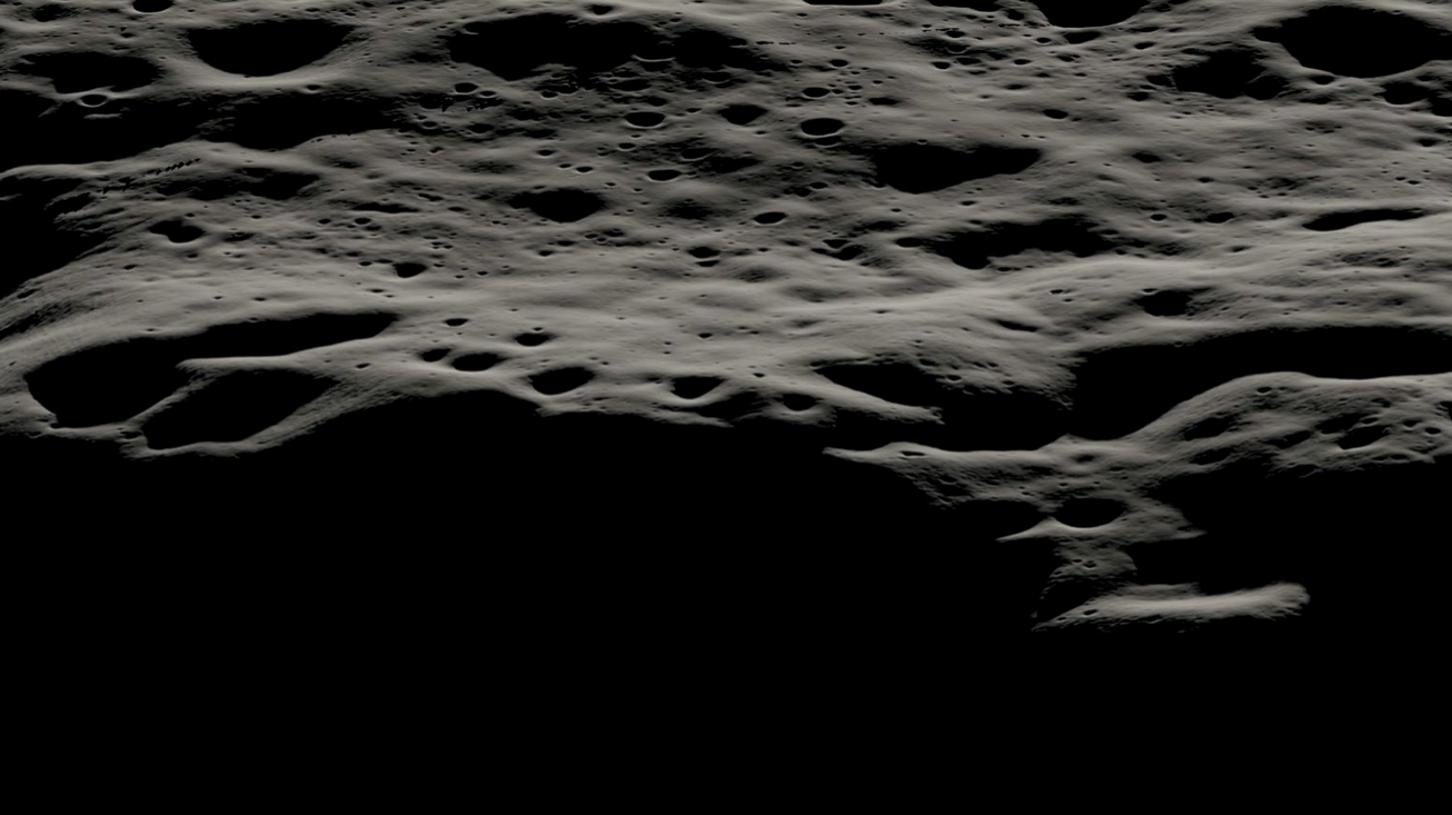
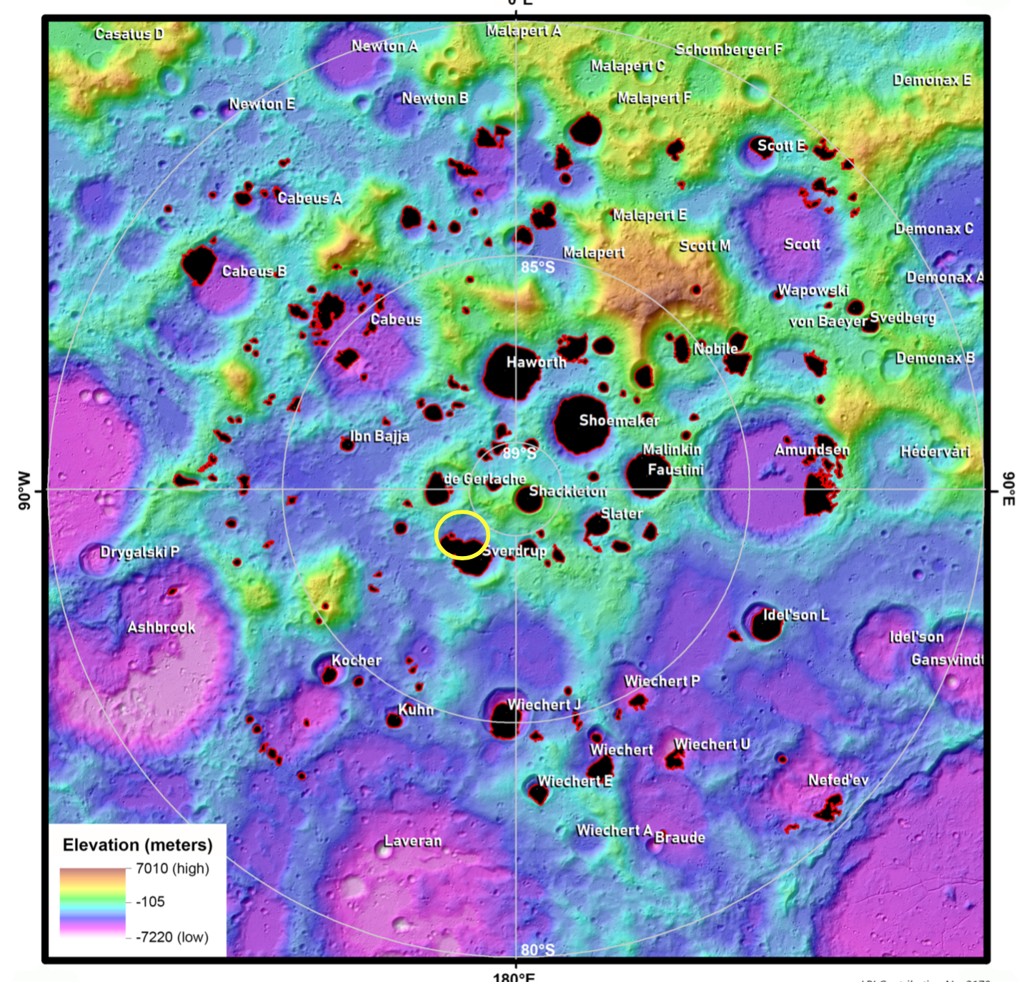
Lunar Crater Named After Arctic Explorer Matthew Henson by International Astronomical Union, Accepting NASA/LPI Proposal
by Frank Tavares
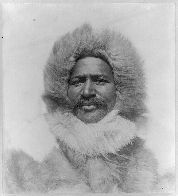
The International Astronomical Union has named a crater at the Moon’s south pole after the Arctic explorer Matthew Henson, a Black man who in 1909 was one of the first people to stand at the very top of the world. The proposal to name the crater after Henson came from Jordan Bretzfelder, an Exploration Science summer intern with the Lunar and Planetary Institute, in Houston, TX, which is a member of the Solar System Exploration Research Virtual Institute, headquartered at NASA’s Ames Research Center in California’s Silicon Valley.
“Creating an inclusive community and achieving equity in the sciences begins by recognizing the contributions of people from all backgrounds,” said Bretzfelder, who is a PhD student at the University of California Los Angeles. “It felt like a disservice that Henson hasn’t been appropriately recognized for his contributions to polar science, and I’m proud to be a part of rectifying that.”
In NASA’s missions today, putting the diverse backgrounds of humanity at the forefront of space exploration is a core part of the agency’s values. Located between Sverdrup and de Gerlache craters at the south pole of the Moon, Henson Crater is in the same region the Artemis program aims to land the next slate of lunar explorers, which will be selected from NASA’s increasingly diverse astronaut pool.
NASA’s Artemis program provides a cornerstone both to study planetary processes and to create the infrastructure to advance human exploration at the Moon and then Mars – a fitting continuation of the incredible journeys Earth explorers like Henson took over a century ago.
Bretzfelder spent her internship working with David Kring of the Lunar and Planetary Institute, mapping out potential landing sites for future Artemis missions at the Moon’s south pole with collaborating students Indujaa Ganesh of the University of Arizona, Nandita Kumari of Stony Brook University, and Antonio Lang of the State University of New York at Buffalo. With so many unnamed features in that region, Bretzfelder thought that naming this crater would both make discussions regarding landing site selection smoother and be an opportunity to highlight an overlooked historical figure in polar exploration.
Henson was an experienced explorer and skilled as a carpenter and craftsman. He was on the front lines of almost a dozen Arctic expeditions organized by Robert Peary over the course of 18 years, including the one that ultimately reached the North Pole.
The final push of that expedition was made by Henson, Peary, and four Inuit companions named Ooqueah, Ootah, Eningwah and Seegloo, all traveling by dog sledge. Henson was in the lead of the group as they searched for the pole.
On that day, because of a mist that covered the Sun, they were unable to tell their precise location. The next morning, they discovered they had overshot the Pole by several miles the day prior – when Henson was out in front. Circling back, Henson found his footprints were first at the North Pole.
Whether Henson was the very first human to ever reach the North Pole is hard to know, as it’s very possible Indigenous people in the Arctic explored the area in the thousands of years they have been present in the region. But it’s clear by his account that he was the first at the pole in Peary’s expedition, and the first person in recent history to have reached the very top of our globe.
Henson was born in 1866 in Maryland, the year after slavery was abolished in the United States. Henson did receive accolades at the time for his historic achievement. However, because many were hesitant to credit a Black man with successfully completing a mission that many others had attempted and failed for centuries, there was controversy that diminished Henson’s role, often giving credit to Peary instead.
“Henson exemplifies the kind of exploration the NASA of today strives to do,” said Jim Green, chief scientist at NASA Headquarters. “When Artemis sends the next generation of astronauts to the lunar surface, it will be our honor to have Henson’s name on our lunar maps.”
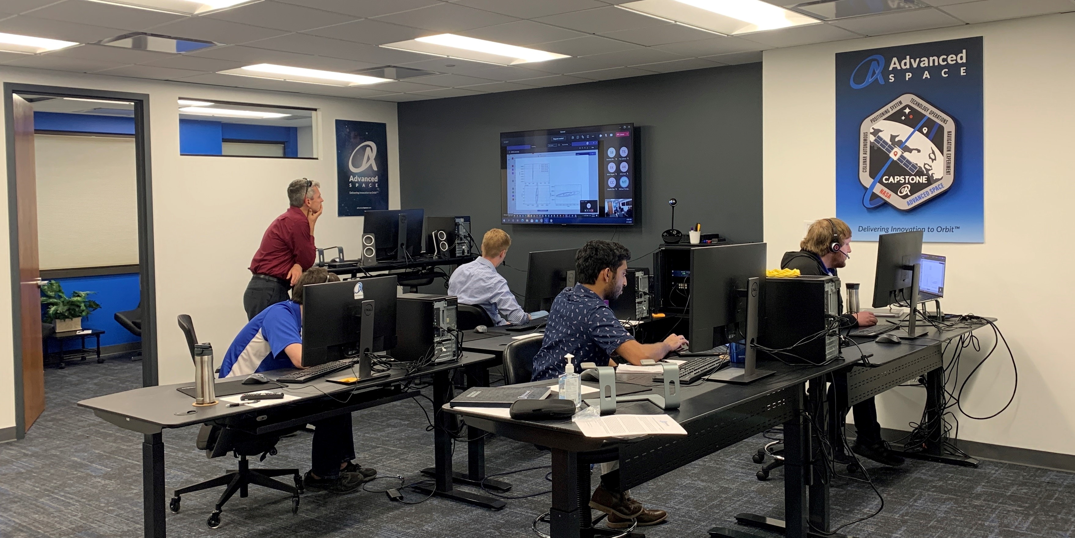
CAPSTONE Team Keeps CubeSat on Track During Simulated Flight
by Gianine Figliozzi
Practice makes perfect. As a Moon-bound CubeSat prepares for launch, the Cislunar Autonomous Positioning System Technology Operations and Navigation Experiment (CAPSTONE) team at Advanced Space’s operations center in Westminster, Colorado, conducted a series of mission simulations. The simulations virtually put the CubeSat through its orbital dynamics paces.
CAPSTONE, a technology demonstration mission, will test a unique lunar orbit that is intended for Gateway, the Moon-orbiting outpost for NASA’s Artemis program. CAPSTONE will demonstrate the ability of its spacecraft – a microwave-oven sized CubeSat – to enter into and maintain this special lunar orbit for approximately six months. The dynamics of this orbit, formally called a lunar near rectilinear halo orbit, or NRHO, have not been tested in spaceflight before. The NRHO takes advantage of a precise balance point in the gravity fields of Earth and the Moon. Spacecraft in this orbit will have a continuous, unobstructed view of Earth that will allow constant communications with mission controllers on Earth.
For the test, the team processed simulated CAPSTONE spacecraft tracking data provided by NASA’s Deep Space Network, to create an accurate prediction of the spacecraft’s location and future trajectory. The mission simulation tests included the team performing the precise, time-critical orbit insertion maneuver into the NRHO. This critical maneuver reduces the spacecraft’s energy so it is captured by lunar gravity. Following the NRHO insertion maneuver, the team executed insertion correction maneuvers, which clean up errors and allows the team to transition to the next expected operations at the Moon. The test also allowed the team to practice responses to potential anomalies during simulated flight to ensure the spacecraft stays on course.
CAPSTONE is commercially owned and operated by Advanced Space in Westminster, Colorado. It represents an innovative collaboration between NASA and industry to provide rapid results and feedback to inform future exploration and science missions.
NASA’s Small Spacecraft Technology program within the agency’s Space Technology Mission Directorate (STMD) funds the demonstration mission. The program is based at NASA’s Ames Research Center in California’s Silicon Valley. The development of CAPSTONE’s navigation technology is supported by NASA’s Small Business Innovation Research and Small Business Technology Transfer (SBIR/STTR) program, also within STMD. Advanced Exploration Systems within NASA’s Human Exploration and Operations Mission Directorate funds the launch and supports mission operations. The Launch Services Program at NASA’s Kennedy Space Center in Florida manages the launch service.
NASA Prototypes New Tracking Tag for Sea Otters and other Wildlife with USGS and Monterey Bay Aquarium
by Frank Tavares
When you think of technology development at NASA, your first thought may be spacecraft and satellites. But one of the latest inventions to come out of the agency’s lead maker space isn’t made for astronauts or engineers – but for sea otters.
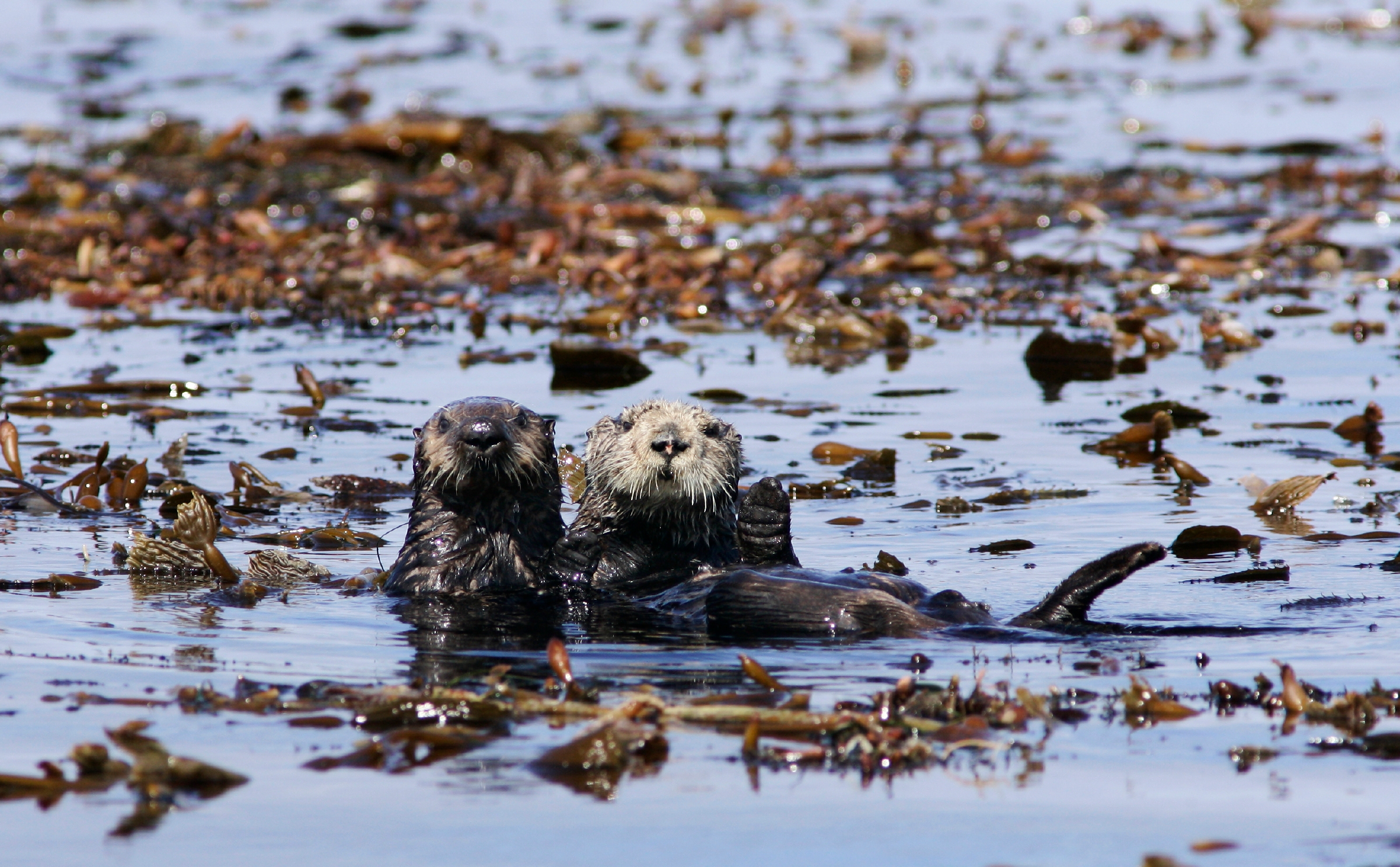
Sea otters are important mammals in marine ecosystems and are essential to maintaining balance in kelp forests. That’s why the Space Shop, a maker space at NASA’s Ames Research Center in California’s Silicon Valley, is developing a modern tracking device designed to humanely fit onto the hind flippers of sea otters. This new and improved tracking device is still being tested, but once it’s ready to be deployed, scientists will be able to track sea otter populations with far more precision and frequency than was previously possible. In the future, the same technology could be used to track other wild animals.
“We’re bringing state-of-the-art tech to the challenge of tracking wildlife,” said Chad Frost, the principal investigator for the project at Ames. “Using modern networking technologies and economical prototyping techniques like 3D printing, this collaboration is creating a new kind of tag that will fundamentally change the scale of science that can come out of tracking wildlife like sea otters.”
The project draws on NASA’s electronics design and fabrication capabilities while partnering with the United States Geological Survey and the Monterey Bay Aquarium for their scientific expertise. The tags have also gone through initial testing with sea otters at the Monterey Bay Aquarium, with more to follow as the project develops.
Previous generations of trackers for sea otters were bulky and expensive, depended on special batteries, and only provided an approximate location of the otter. Today’s technology offers far better solutions, creating a network of animal trackers that can deliver accurate, GPS-enabled otter locations more frequently, in a much smaller, low-cost, and minimally invasive solar-powered tag.
Printing a New Tag
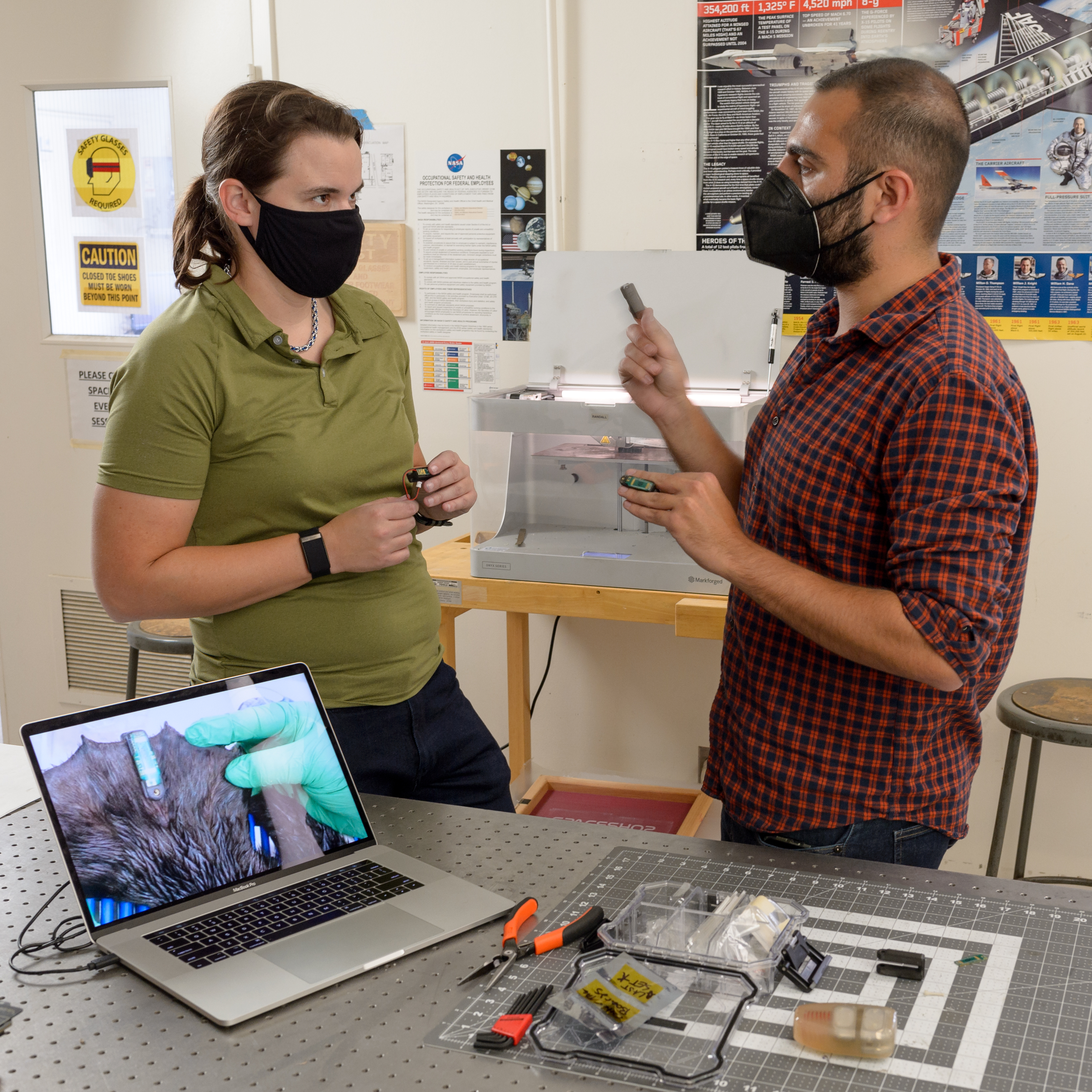
The Space Shop at Ames is one of NASA’s main facilities for plastic 3D printing, making it the ideal place to prototype and produce the otter tag’s housing, which keeps the electronics of the tag safe and secured to the otter.
“Designing a tag for an otter is very different than normal electronics enclosures,” said Elizabeth Hyde, a research engineer with USGS who previously worked at NASA on this same project. “Not only do you have the rigors of a marine environment to deal with, but also the unique anatomy and behavior of the otters as well.”
The team had to fabricate a device to withstand salt water and the sea otter’s strong jaws and teeth, designed for crushing the hardest of shellfish, all while not harming the otter and protecting the electronics that are housed inside.
Early prototypes were quickly mocked up using 3D printing, with cheaper materials to experiment with different designs, iterating to find the exact design that works for scientists and the otter.
Then, the team broached the question of what permanent material to use. It needed to be something flexible enough to withstand impacts without breaking, and be strong and durable. The team converged on a material mostly made of nylon, with carbon fiber particles as well for added strength.
“This was a really exciting design challenge for us,” said Alex Mazhari, manager at the Space Shop’s Rapid Prototyping Lab. “Being able to rapidly prototype a cost-effective solution to enable better science speaks to the value of the Space Shop not just for NASA, but our partners as well.”
A Key to Marine Ecosystems
Sea otters are what are known as a keystone species. That means that their effect on local ecosystems is especially important, and that changes to the sea otter population can have a cascading impact. For example, a primary food source for otters are sea urchins, which consume kelp. Without sea otters, kelp forests can be totally depleted by urchin populations allowed to surge in the absence of a major predator.
Beyond being a home for all kinds of marine life, kelp forests can also absorb carbon dioxide that otherwise lingers in the atmosphere, contributing to global warming.
Understanding how otters and other animals interact with their changing environments is critical for deciphering the impacts of climate change on wildlife and ecosystems. The technology produced for this tag can be repurposed for all kinds of wildlife and will feed into another project being developed in parallel for tracking birds and other animals.
“When we have these significant gaps in tracking, we can miss how these species are interacting with their ecosystems as they are impacted by climate change,” said John Stock, the director of the USGS’s National Innovation Center. “We have a responsibility to understand how endangered and threatened species are reacting.”
The sea otter tags will continue to be tweaked and tested for some time before they are ready to be deployed on sea otters in the wild by the USGS’s Western Ecological Research Center. But once they do, the tags will be the start of a new generation of wildlife tracking and a key tool in understanding how climate change is impacting one of the most important species to our marine environments.
Wildfire Workshop Finds Ways NASA Aero Tech Can Fight Fires
by Rachel Hoover
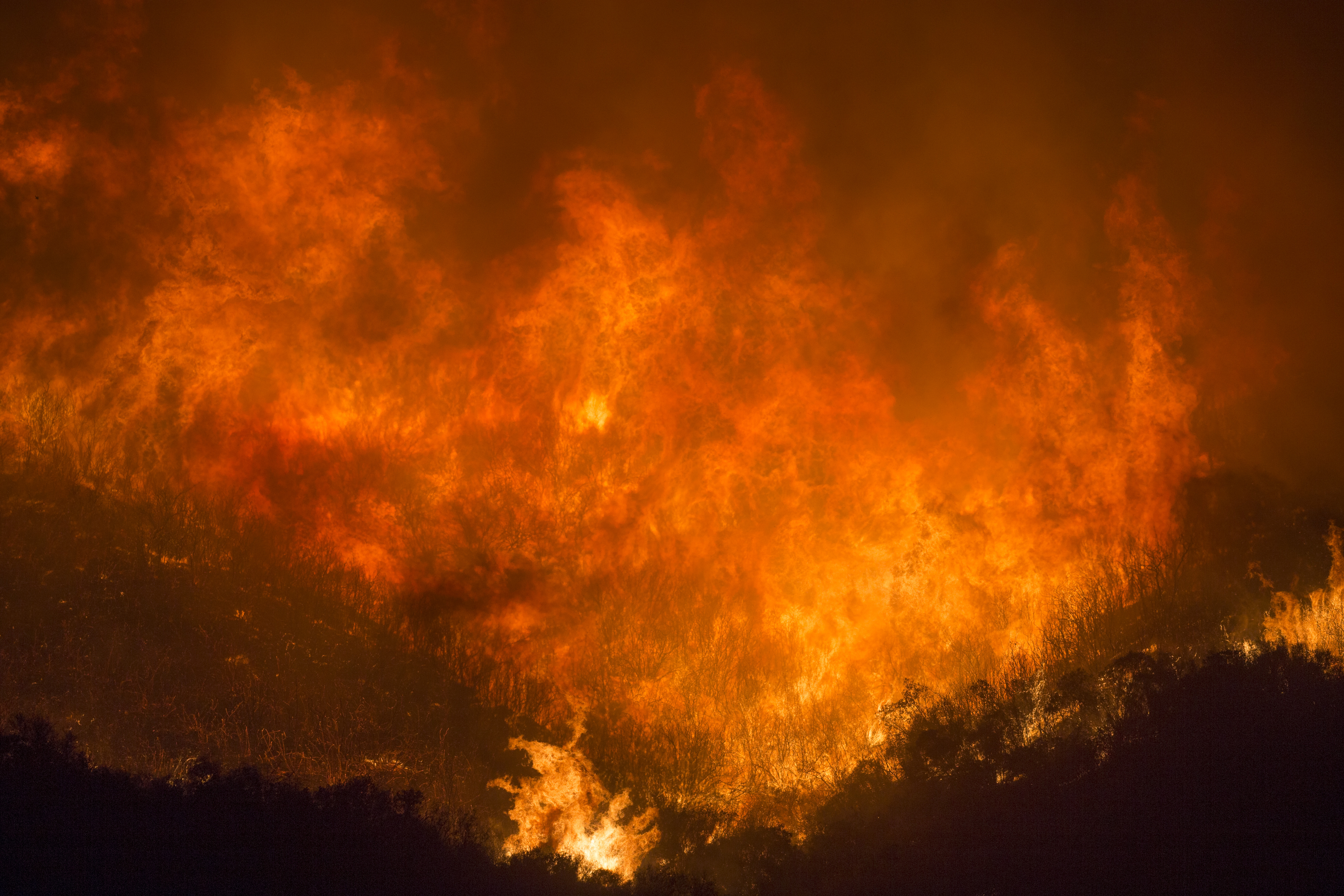
Wildfires in the United States are bigger, increasingly dangerous, and more costly than ever before. California and other states are facing a prolonged drought along with hotter temperatures brought about by a changing climate. This means once a wildfire takes hold, more acres succumb to intense flames, which puts more people and homes in harm’s way. But there are wildfire prevention and firefighting solutions that could help organizations better manage these emergencies.
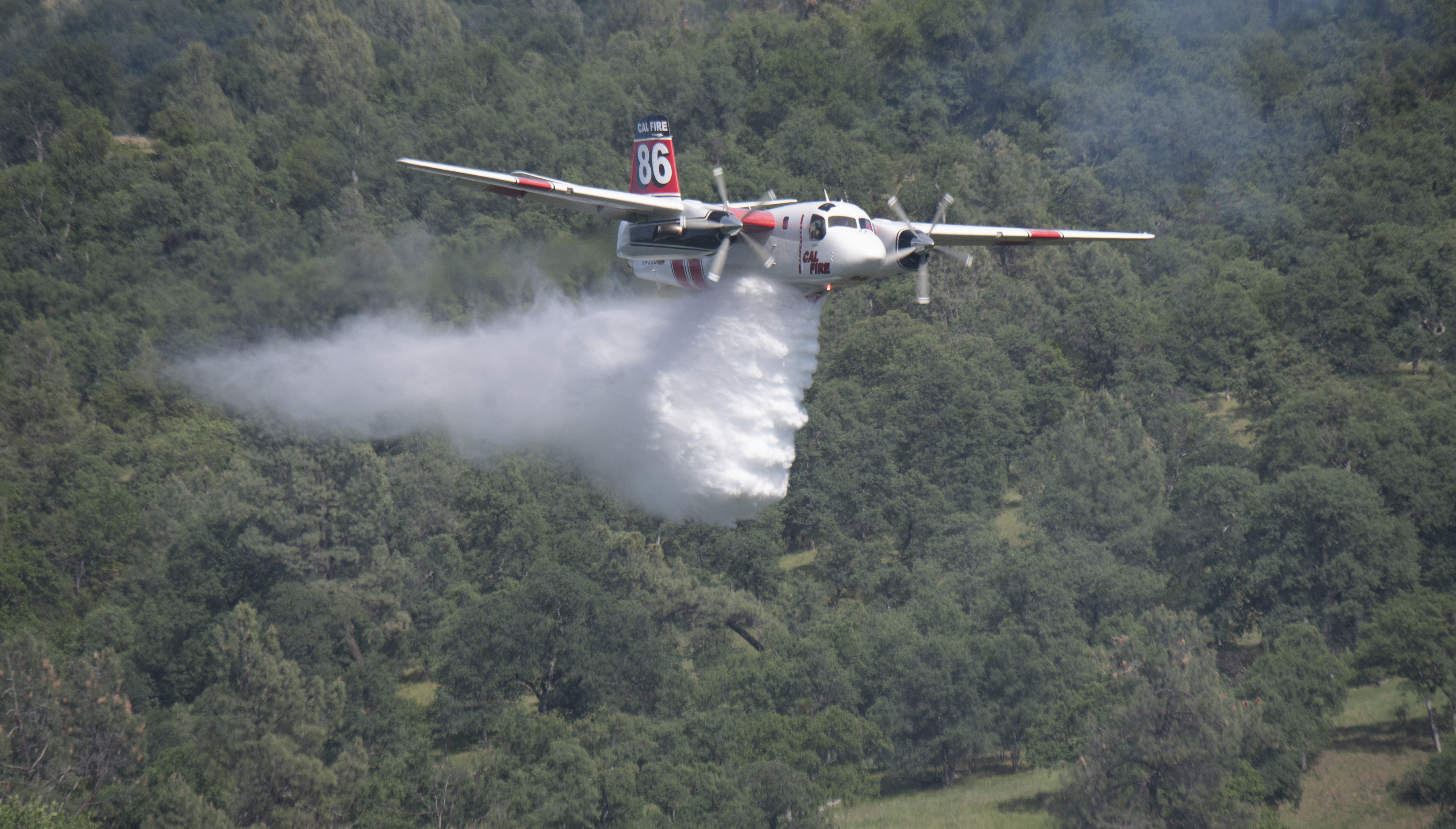
That’s why NASA hosted a virtual Wildfire Management Workshop in May 2021 on behalf of the agency’s Aeronautics Research Mission Directorate. Members from across the agency along with the wildfire management community, including government, private, and academic organizations, gathered to share insights into the needs, challenges, and solutions to be more effective.
The findings from this workshop will help inform NASA’s contributions to future wildfire management and prevention efforts. NARI recently posted a report from this workshop to the agency’s website.
“From this workshop we learned more ways NASA can leverage our aviation expertise, technologies, and assets to better enhance others’ ability to detect and suppress wildfires,” said Robert Pearce, associate administrator of NASA’s Aeronautics Research Mission Directorate.
One possible contribution to help manage firefighting and mitigation efforts are the powerful NASA-developed decision support tools used to coordinate airspace operations. These tools, referred to as unmanned aircraft systems traffic management, or UTM, help manage large numbers of drones flying at low altitude, along with other airspace users. For example, NASA’s Scalable Traffic Management for Emergency Response Operations, or STEReO, research activity has been exploring the use of UTM technologies and concepts to improve collaboration and provides frontline firefighters the high-resolution, real-time information they need.
NASA’s aeronautics community is exploring additional ways to utilize its technologies on aircraft – including drones – and put them into service to help fight fires and collect data.
“Each year, millions of people across the globe are impacted by wildfires – fire management is a national priority, and NASA has a lot to offer,” said Parimal Kopardekar, director of the NASA Aeronautics Research Institute, or NARI, at the agency’s Ames Research Center in California’s Silicon Valley. “NASA is positioned to provide assistance and solutions – including tools for collecting data as well as data access and management, modeling, and collaboration – to better meet the needs of the firefighting community.”
NASA is assessing the workshop outcomes to identify opportunities for NASA to further support wildfire management, and could lead to leveraging NASA technologies to support other public disasters including volcanoes, earthquakes, or floods. Firefighters already benefit from NASA satellite data for remote sensing, instrumentation, mapping, data fusion, and prediction tools provided by NASA’s Science and Space Technology Mission Directorates.
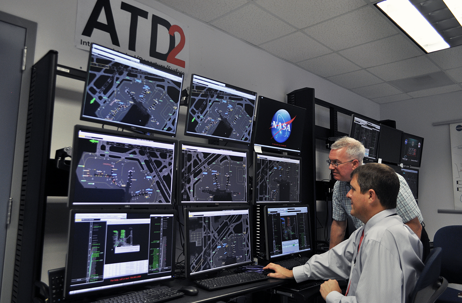
What is the Airspace Technology Demonstration 2?
NASA technology helps air travelers get smoothly from gate to sky
by Abigail Tabor
After more than a year of pandemic-related travel restrictions, many people excitedly boarded planes to take them on long-awaited vacations. Plenty then sighed and settled in for a long wait: their takeoff was delayed, and they’d be sitting on the tarmac a while. Commercial air travel relies on intricate operations at the airport, and, with so many variables in play, inefficiencies can easily crop up.
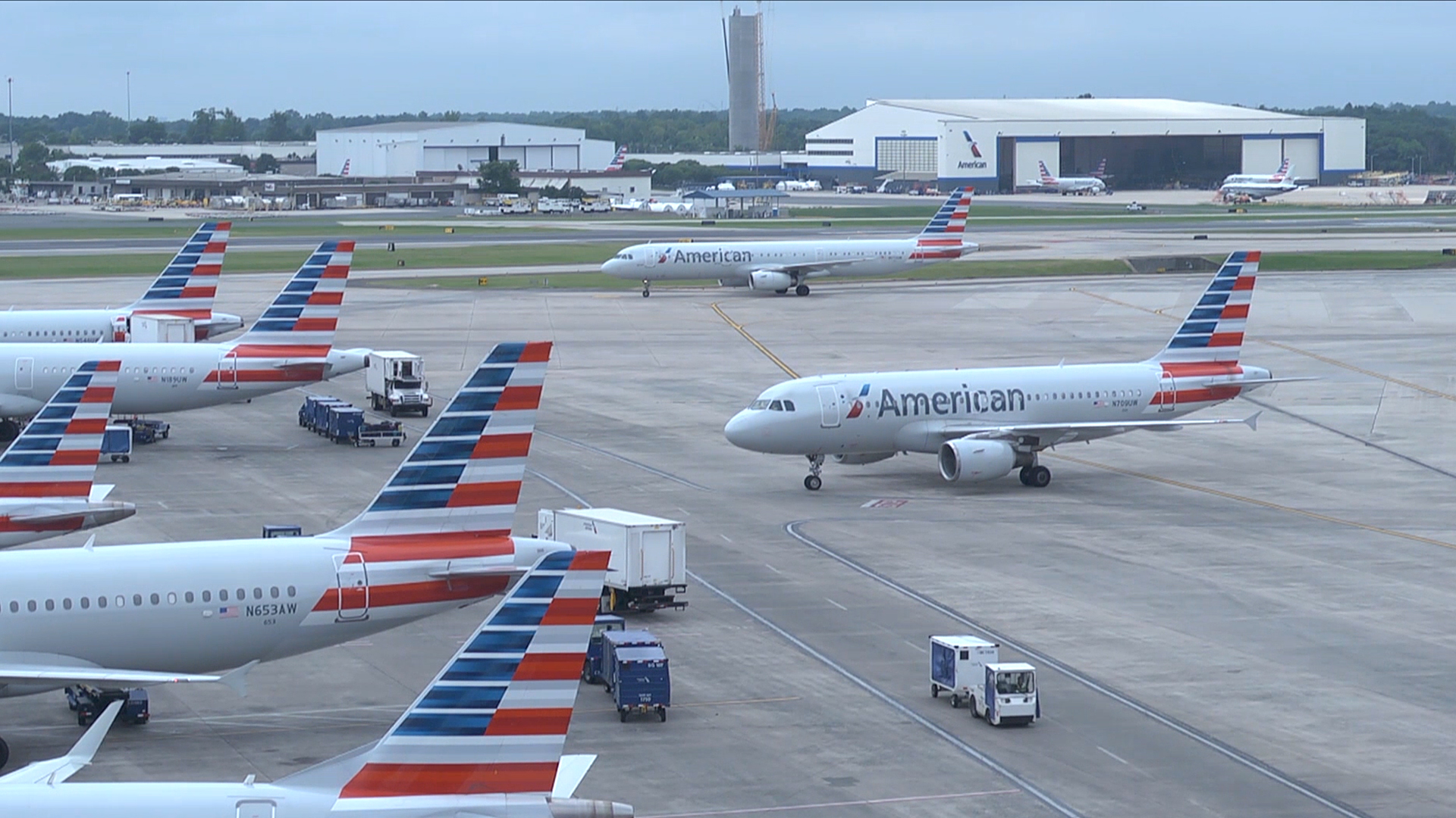
That’s something NASA’s Airspace Technology Demonstration 2, or ATD-2, project aimed to change. One of a trio of projects tackling challenges faced in air traffic management, ATD-2 developed technologies that predict airport traffic conditions and determine the best time for departing flights to push back from the gate.
This both reduces delays and shifts wait time to the gate, instead of on the taxiway with engines running. The ultimate goal is to get travelers from gate to runway to the sky with minimal delay. And the benefits – for schedules, passengers, airlines, and the environment – are already adding up.
Optimizing the Flow of Flights
Most of us take for granted everything that goes into running a functional airport. But a great deal of information on arrivals, departures, surface traffic, delays, sudden changes in weather, and more must be tracked, communicated, and adjusted for by different groups of people.
The current system handles all this using a simple physical queue: when a plane is ready for departure, it gets in line and waits to use the runway. But, when unexpected problems arise, this queue can quickly back up, affecting both departures and arrivals. To protect against those consequences, air traffic managers may add more buffer time to flight schedules – an additional inefficiency.
By making the movements of aircraft from surface to sky more predictable, NASA researchers aimed to help reduce that buffer, and optimize the flow of flights through airports. The ATD-2 tools help get planes queued up in the best way to take their designated spot in the air traffic overhead.
More Communication, More Efficient Flights
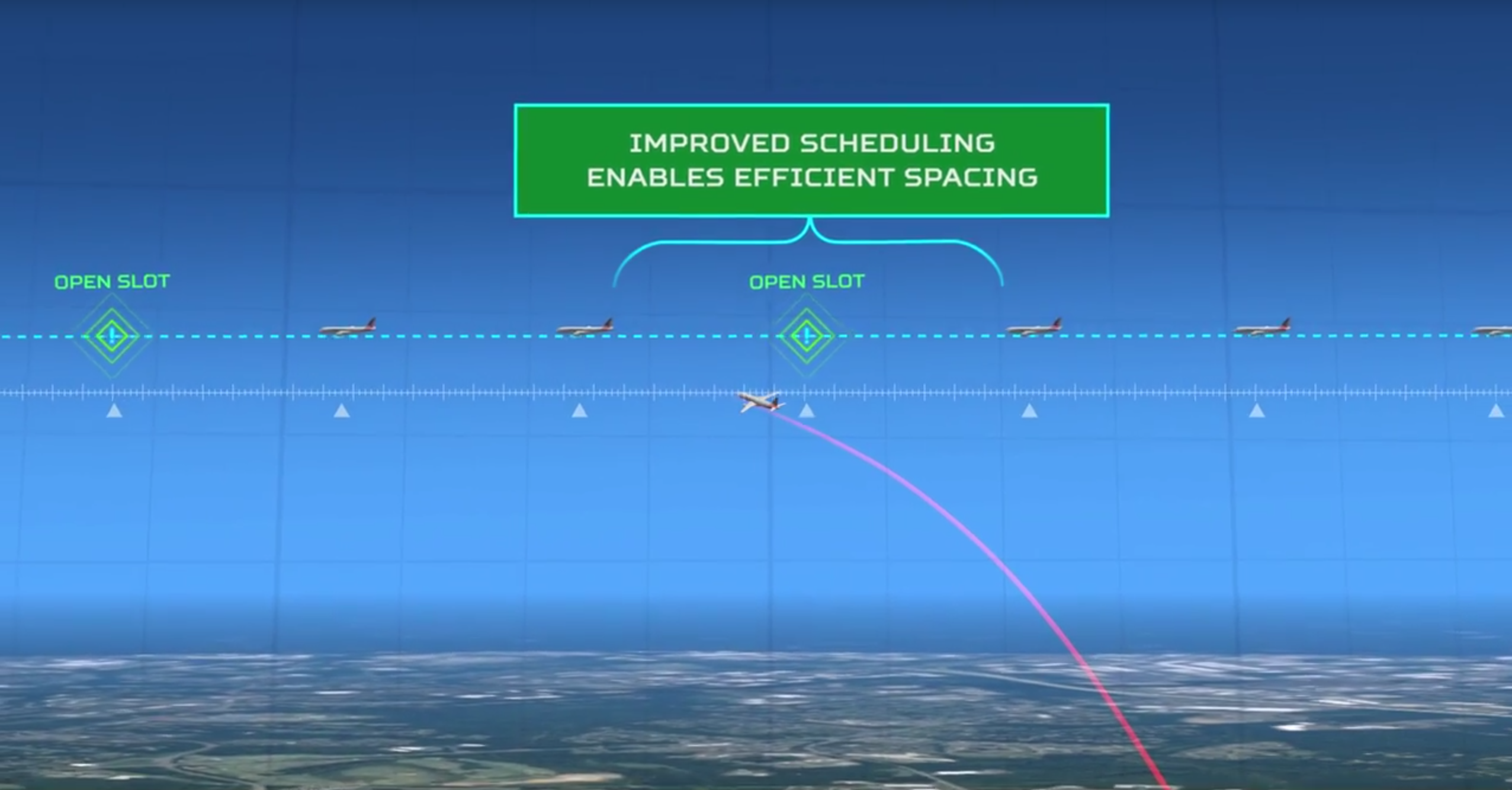
At the heart of ATD-2’s approach is integrating numerous inputs of data from the Federal Aviation Administration and airlines and transforming that data so it’s easily shared across the various systems at work. The system is at work during parts of a flight controlled by the FAA and those where the airlines are in charge, on the ground.
A key realization underlying ATD-2 is that traffic congestion on the airport surface can’t be solved in isolation. You also have to account for the traffic operating in the surrounding airspace. Instead of having separate systems for arrivals, departures, and surface traffic, ATD-2 created one system to manage all these phases of flight. The software is called Integrated Arrival/Departure/Surface Traffic Management, or IADS.
Rather than having planes line up in a physical queue as soon as they’re ready to leave, the IADS scheduler creates a virtual queue, like a restaurant reservation system. That way, wait time can be spent at the gate with the engines off and the door open rather than on the ramp or taxiway burning fuel. The result is a more efficient and environmentally friendly operation.
By integrating data from previously independent systems, the ATD-2 IADS system provides operators in different facilities with a shared understanding of the airport traffic situation. ATD-2’s tools also include apps that users consult to know which aircraft should be in position, and when, for the whole process to work most efficiently. Everyone involved can see the different factors in play and the common goal to work towards.
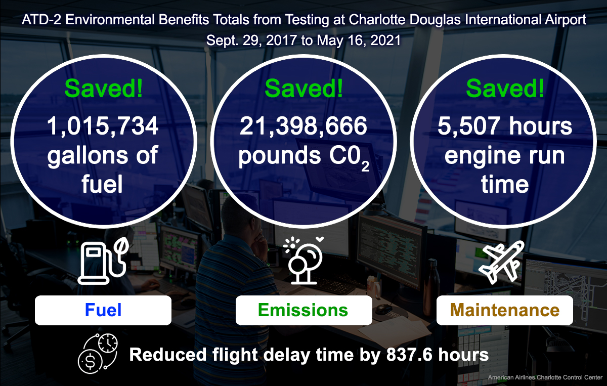
One Million Gallons Saved
The ATD-2 team first put their air traffic scheduling technology to the test with real-world users in September 2017 at Charlotte-Douglas International Airport in North Carolina. With partners from the FAA, commercial airlines, and the air traffic controllers’ union, they were able to show how improvements from ATD-2’s approach can drastically cut down delays and reduce emissions.
By May 2021, the IADS tools had saved more than one million gallons of jet fuel. The amount of carbon dioxide emissions avoided was equivalent to planting more than 159,000 trees in an urban environment. Those savings were made possible by reducing jet engine run time, which also decreases maintenance costs. Overall, passengers were spared 837 hours in flight delays and saved an estimated $4 million in value of time. Airlines also saved an estimated $1.2 million in flight crew costs.
And that’s only at one airport. The benefits will be sky high if the ATD-2 tools are one day put into action at airports around the nation. With the end of the project in September 2021, NASA passed its research results and technology developed to the FAA and industry partners. The FAA’s Terminal Flight Data Manager program will roll out IADS capabilities – made possible by NASA’s pathfinding work – to 27 major airports in the coming years.
ATD-2 included two separate field demonstrations of the Integrated Arrival Departure Surface, or IADS, system:
A single-airport demonstration at Charlotte Douglas International Airport in North Carolina (Sep. 2017-Sep. 2020)
NASA developed core components of the IADS system and used them to validate concepts developed by the FAA and industry. In addition to the technology that was transferred by NASA, lessons were learned from the demonstration that reduced risk for the FAA’s implementation of the ATD-2 capabilities and established the business case for required industry investments.
A multi-airport demonstration at Dallas/Ft. Worth International and nearby Dallas Love Field airports in Texas (April-Sep. 2021)
The team extended the single-airport tools to improve the efficiency of surface operations at neighboring airports, where departing flights compete for limited airspace resources. Using IADS’ surface traffic predictions, NASA’s terminal scheduler tool assessed demand to use the airspace versus its capacity and provided recommendations for efficient rerouting of flights.
Milestones:
ATD-2 included two separate field demonstrations of the Integrated Arrival Departure Surface, or IADS, system:
- A single-airport demonstration at Charlotte Douglas International Airport in North Carolina (Sep. 2017-Sep. 2020)
NASA developed core components of the IADS system and used them to validate concepts developed by the FAA and industry. In addition to the technology that was transferred by NASA, lessons were learned from the demonstration that reduced risk for the FAA’s implementation of the ATD-2 capabilities and established the business case for required industry investments.
- A multi-airport demonstration at Dallas/Ft. Worth International and nearby Dallas Love Field airports in Texas (April-Sep. 2021)
The team extended the single-airport tools to improve the efficiency of surface operations at neighboring airports, where departing flights compete for limited airspace resources. Using IADS’ surface traffic predictions, NASA’s terminal scheduler tool assessed demand to use the airspace versus its capacity and provided recommendations for efficient rerouting of flights.
Partners:
The Airspace Technology Demonstration 2 was run out of the Aviation Systems Division at NASA’s Ames Research Center in California’s Silicon Valley, in collaboration with the Federal Aviation Administration. The project was managed by NASA’s Airspace Operations and Safety Program. American Airlines, Southwest Airlines, the National Air Traffic Controllers Association, Charlotte Douglas International Airport, Dallas/Ft. Worth International Airport and Dallas Love Field Airport all partnered with NASA in the field demonstrations.
NASA Small Business Partners Advance Lunar Technologies
by Rachel Hoover
Small businesses around the country have played a critical part in NASA technologies that enable our missions. As NASA returns to the Moon via the Artemis program, in an enhanced, sustainable way; the agency has selected five U.S. small businesses to receive a total of nearly $20 million to accelerate the development of novel lunar capabilities.
The investments support NASA’s Artemis strategy of collaborating with commercial partners. These technologies all aim to tackle key and critical lunar capabilities, environmental challenges, and risks. Should these efforts be successful, they will enable a range of approaches, functionality, and improvements for multiple NASA programs, missions, and collaborators in our return to the Moon.
The companies began maturing the technologies and demonstrated their potential under previous Small Business Innovation Research and Small Business Technology Transfer (SBIR/STTR) contracts. These follow-on Sequential Phase II awards aim to accelerate the development of technologies that NASA, and potential partners and commercial companies, need in the near future that will enable and enhance our sustainable lunar science and exploration. It is the second year NASA has made this small business award, valued at $2.5-5 million per company.
- Advanced Cooling Technologies Inc. in Lancaster, Pennsylvania, will mature thermal technologies into systems that may enable Moon rovers, vehicles, and landers to survive, explore, and conduct science during the frigid and long lunar night.
- Alameda Applied Sciences Corporation in Oakland, California, will develop a beyond low-Earth orbit small satellite propulsion system that will enable a range of new and more affordable approaches to distributed science missions, lunar communications networks, and more.
- Ashwin-Ushas Corp Inc. in Marlboro, New Jersey, also will advance a thermal control technology that may enable rovers to conduct science and explore more of the challenging and dynamic lunar environment, including traveling into and out of the Moon’s dark, permanently shadowed craters.
- Motiv Space Systems Inc. in Pasadena, California, is creating an integrated, scalable drive actuation system that could operate in various extreme environments. This technology could be integrated into rovers, landers, and more, for a range of movement and robotics needs; helping aid construction, maintenance, scouting, and other applications on the Moon and Mars.
- Troxel Aerospace Industries Inc. in Gainesville, Florida, will advance a new approach that may enable high performance computing avionics that are not radiation-hardened to operate in the high radiation environment beyond low-Earth orbit. This innovation could enable new avionics for radiation-tolerant spacecraft displays, spacesuit heads-up displays, improved science data processing systems, hazard avoidance systems during entry, descent, and landing, among others.
While NASA looks to benefit from the technology development, small businesses see broader benefits.
“The side effects of being able to work these programs is significant to the growth of our company,” said Tom McCarthy, vice president of Motiv Space Systems. Motiv has worked with NASA SBIR/STTR since the early 2000s. “It has allowed us to sustain, hire, and bring in new talent and keep up the technical edge for future customers that need unique solutions.”
NASA’s SBIR/STTR program worked closely with other agency programs to identify key technical challenges and risks for near-term mission requirements, demonstration possibilities, and infusion opportunities. Earlier this year, NASA released a call for white papers to previous SBIR/STTR Phase II awardees from the last decade to meet these needs. NASA invited select companies to submit full proposals. These technology acceleration efforts will be overseen in conjunction with key NASA projects, programs, and stakeholders. Future sequential calls for white papers and awards are possible.
Through the SBIR/STTR program, NASA pilots initiatives to help small businesses accelerate infusion into space missions and commercialization into the marketplace. NASA invests in disruptive capabilities in emerging markets, increasing the country’s competitive advantage and generating opportunities for job creation across the country. The program is part of the Space Technology Mission Directorate (STMD) and is managed by NASA’s Ames Research Center in California’s Silicon Valley.
NASA Lab Studies Sleepiness and Use of Automated Systems
by Abigail Tabor
Drowsy driving accounts for a large proportion of car crashes, according to the National Highway Traffic Safety Administration. So, you might think self-driving cars would fix that. After all, computers just don’t get sleepy.
But today’s vehicles are only partially automated, requiring the human driver to stay alert, monitor the road, and take over at a moment’s notice. A new study conducted by the Fatigue Countermeasures Lab at NASA’s Ames Research Center in California’s Silicon Valley suggests this passive role can leave drivers more susceptible to sleepiness – especially when they’re sleep deprived.
The research was carried out to help understand how humans interact with autonomous systems, such as those used in aircraft and in spaceflight systems. The findings will contribute to the agency’s research around the safe introduction of automation in aviation and the growing complexity of advanced systems. They also suggest drowsy drivers may be an important consideration for safe introduction of self-driving features in cars.
Drivers Pave the Way for Pilots and Astronauts
NASA’s Fatigue Countermeasures Lab is primarily interested in sleep, or the lack thereof, as it concerns pilots and astronauts, who may be fighting fatigue when carrying out complex tasks on the job. Autonomous systems are becoming more common in both aviation and spaceflight, and some pilots report using autopilot as backup when coping with sleepiness during a flight.
Knowing that our ability to keep monitoring an uneventful situation goes down when we’re sleep deprived, researchers wanted to understand how this might affect the use of autopilot. Since driving is, in many ways, a similar task to flying and drivers are a lot more common than pilots, the lab decided to study them first.
The team looked at whether people on their ordinary sleep schedules would show more sleepiness supervising a self-driving vehicle, compared to manually controlled driving. The Centers for Disease Control and Prevention report that many people across the country don’t get enough sleep, and study participants had the same range of habits as the general population. Many of them got much less than the recommended seven to eight hours of sleep per night in the week before the study.
Participants in three separate experiments completed two 48-minute sessions in a driving simulator. In one condition, they had full control of the simulator’s steering wheel, gas pedal, and brake. In another, they used self-driving mode and had no control of the vehicle dynamics but were instructed to keep their hands on the steering wheel while monitoring the vehicle. On a screen in front of them, all participants saw a flat, monotonous, two-lane road in the countryside roll by, with little traffic and no stop signs or traffic lights.
The drivers wore electrodes during both sessions to monitor brain activity and eye movements characteristic of falling asleep. Immediately following each drive, they rated their sleepiness on a standard scale and completed a test to evaluate attention.
The results showed that, when supervising – rather than actively operating – the vehicle, participants reported feeling sleepier and showed increased signs of “nodding off.” They also showed slower reaction times compared to actively driving the car. And the more sleep deprived a person was, the stronger these effects were.
“The bottom line is not that self-driving cars are more or less safe than manually driving,” said Erin Flynn-Evans, director of the Fatigue Countermeasures Lab. “It’s that when people don’t get enough sleep, they are vulnerable in both driving scenarios.”
Fatigue in Flight and on the Road
Now that they understand more about the relationship between fatigue and people’s ability to keep tabs on an autonomous system, the researchers will apply this knowledge to their work in aviation. Future studies could include working with pilots using flight simulators and, later, on actual flights.
Since astronauts, too, will likely have highly automated procedures for the Artemis lunar missions and eventual Mars missions, NASA is using this study to help design such procedures and related policies, including scheduling enough time for those astronauts to sleep.
“Our goal is to help NASA understand where there are important targets for future research concerning pilots and astronauts,” said Flynn-Evans. “We hope that our work will help the research community understand how people’s ability to monitor a situation is different from their ability to actively engage in it.”
The findings have implications for commercial truckers and others whose vehicles are using more and more automation. The results also highlight the need to continue studying fatigue and safety in partially autonomous systems. As the operator’s role shifts to one of passive supervision, solutions could be developed to help sleepy drivers stay engaged and alert. Meanwhile, everyone driving should make sure to get enough sleep until, one day, fully autonomous vehicles may be ready to take the wheel.
NASA is Recruiting Candidates for Crew Health and Performance Exploration Analog (CHAPEA)
Applications to participate as crew are being accepted now through 5 p.m. CST Sept. 17, for the one-year analog mission that starts in Fall 2022.
Qualifications:
Crew selection will follow standard NASA inclusion and exclusion criteria for Astronaut Candidate applicants.
- Be a U.S. citizen or permanent resident.
- Be within the ages of 30-55.
- Possess a master’s degree* in a STEM field, including engineering, biological science, physical science, computer science or mathematics, from an accredited institution.
- Have at least two years of related professional experience in a STEM field or at least 1,000 hours pilot-in-command time on jet aircraft.
- Be able to pass the NASA long-duration flight astronaut physical.
*The master’s degree requirement also can be met by:
- Two years (36 semester hours or 54 quarter hours) of work toward a doctoral program in a related science, technology, engineering or math field.
- A completed Doctor of Medicine or Doctor of Osteopathic Medicine degree.
- Completion (or current enrollment that will result in completion by June 2021) of a nationally recognized test pilot school program.
*Participants with a Bachelor’s degree and other specific qualifications (e.g., relevant additional education, military, or at least four years of professional experience in a STEM field) may also be considered.
Application Process:
Finalists will undergo medical evaluations, psychological testing, and psychiatric screening to determine suitability for a physically and mentally demanding long-duration isolation mission. All exams and their associated expenses will be arranged and paid for through NASA. Candidates will not be selected if they have any food allergies, avoidances, or gastrointestinal disorders, as these cannot be accommodated on a long-duration mission. Candidates must be willing to provide requested biological samples on required days and must eat the spaceflight-like diet provided during the mission. Candidates must not be prone to motion sickness with virtual reality equipment. Candidates on specific medications will be disqualified: Examples- blood pressure medications, blood thinners, seizure medications, daily allergy medications, diabetic insulin daily, sleeping aids, ADHD/ADD medications, antidepressants, anxiety medications. Food supplements will not be permitted during the mission. Vitamin D is provided during the missions. All other vitamins are available in the spaceflight food system and added vitamins are not permitted. Candidates will be required to have a COVID-19 vaccine and show proof of full vaccination. Candidates will be required to get their own COVID-19 PCR test and show proof of a negative test. Participants will be required to follow COVID-19 Risk mitigation protocols current to the JSC campus upon visiting.
Candidates who participate in this protocol are not guaranteed selection for the analog missions. The selection process timeline may take up to 13 months, with a maximum of 16 days of active time required by a candidate throughout this time. This includes time filling out the application, travel time, time at JSC for prescreening activities, and time at the National Outdoor Leadership School. Not all candidates will continue to each phase of screening. Crew selection applications will be evaluated in the order received for qualified applicants until all available spots are filled.
Compensation is available, and more information will be provided during the crew candidate screening process.
Risks of participating in this protocol may include loss of subject privacy or confidentiality, minor discomforts and low level radiation exposure from x-rays during medical exams, and physical injury or a highly unlikely chance of death. Mitigations include data protection on authenticated and encrypted systems, use of licensed and approved medical clinics, and safety mechanisms and injury prevention training.
How to Apply:
Qualified candidate test subjects should apply now to have an opportunity to contribute to NASA’s work in preparing to journey to Mars. Learn more at: https://external.jsc.nasa.gov/chapea/
In Memoriam . . .
Lana “Lynn” Albaugh, Ames Imaging Archivist, Passes Away

Lynn was one of the Office of Communications team members from the FILMSS contract at Ames, who interacted with so many across the center and agency.
Men were walking on the moon when Lynn began her career at NASA. She had firsthand knowledge of every photo that had been entered into the Ames Image Library since 1972 and a clear understanding of pictures that make up the photo library since the groundbreaking in 1939 – more than 700,000 images. Lynn spent countless hours researching and retrieving photos that helped tell our story. She provided this level of support not just to the Ames community, but to other NASA centers, government agencies, and public requests from around the world. Lynn was the recipient of a 2018 NASA Honor Award Silver Achievement Medal for her contributions to NASA.
Lynn’s comprehensive knowledge of Ames’ history was an extension of the relationships she nurtured with many across the center. She kept a dish of candy just inside the doorway of the archive that invited people passing by to drop in and share their latest news. The hand that reached though the doorway to grab a chocolate would soon pass a smartphone packed with family pictures for Lynn’s joyful review.
She enjoyed celebrating the holidays by decorating her office area and loved cooking her favorite dishes during special staff lunches. This included St. Patrick’s Day with her famous corned beef and cabbage and other delicious crock pot dishes. She liked to travel overseas and visited such places as Ireland and Scotland. Lynn really enjoyed country and western music, gardening and crossword puzzles. Her garden included vegetables of all kinds as well as flowers of all types and colors. She especially loved yellow daffodils. She loved her cats and her little dog Jacob.
The news of her passing is very difficult, especially during these already challenging and trying times. The Employee Assistance Program, or EAP, (company code is: NASA Ames) is available for civil servants and offers counseling services and a wide array of other resources. NASA’s EAP also provides a 24-hour service that can be reached for urgent matters outside of business hours at 800-344-4222. Many companies have similar services, and contractors can contact their employers for details about their benefits. Please do not hesitate to reach out for these important services and for support.
Lynn will be cremated, and her ashes spread at sea at the Farallon Islands per her wishes. Due to the COVID-19 pandemic, the family has not yet finalized memorial service arrangements. She is survived by her son Mike Albaugh, daughter Pamela Musladin, grandson Garrick Musladin, daughter-in-law Astrid Albaugh and her son Henry Terlep and wife Aurora Terlep, her daughter Chelsea Colin and husband Luis Colin and their son Keanu Colin.
A NASA flag will be flown at Ames in remembrance of her tireless service. The loss of Lynn has been felt by many and will continue to be felt for many years to come. She will be greatly missed by her Ames family.