


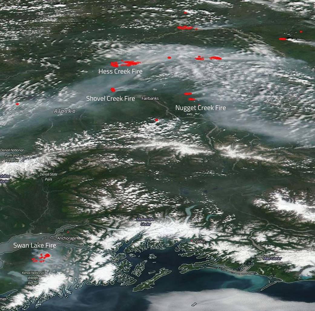
There are many fires ongoing in the state of Alaska, but two of the largest are visible in this satellite image – Hess Creek Fire and Swan Lake Fire.
Hess Creek fire began on June 21 with a lightning strike. The location of the flash point is 29 miles southeast of Steven’s Village, AK. At present the fire area is experiencing near red flag warning conditions however, a frontal passage with cooler temperatures is predicted. Currently, the fire has burned 85,384 acres. The Hess Creek Fire has nearly doubled in acreage during the last few days, burning heavily in black spruce vegetation. The fire is very active and seeing the most growth on the eastern and southwestern edges of the perimeter. Due to the Hess Creek Fire’s size and growth, fire managers do not anticipate pursuing full suppression of this fire. Rather, they will focus firefighting efforts on protecting resources and values at risk.
The Swan Lake Fire located southwest of Anchorage began with a lighting strike on June 5, 2019 in the U.S. Fish and Wildlife Kenai National Wildlife Refuge. At risk are the homes and private properties in and around the community of Sterling, the Sterling Highway and its associated utility right of ways and infrastructure, natural gas pipeline and structures, shelter cabins and the moose research center.
Fire managers have focused all suppression efforts to 5.5 miles east of the community of Sterling. Black spruce is the primary carrier of the fire. There is 40-50% mortality in white spruce stands increasing their flammability. Fuels are becoming critically dry. At present the Swan Lake fire is 70,330 acres in size and is 15% contained at present.
Two smaller incidents are also visible in this satellite image. The Shovel Creek fire and the Nugget Creek fire. The Shovel Creek fire is not a small fire by any means at 10,639 acres but is smaller than the very large fires discussed above. This fire was ignited on June 21, 2019, the same day as the Hess Creek fire and with the same start type. Lightning strikes in the area from a storm caused the ignition of this fire as well. This fire is located 20 miles northwest of Fairbanks. Currently, the fire is threatening 36 private properties with structures to the north on the Chatanika River. The closest of these is less than 0.5 miles directly to the north of the fire. In the next 72 hours, 145 structures in the Murphy, Lincoln, McCloud, Perfect Perch, and Martin Subdivision will also be threatened. Although the area is currently seeing some rain in the forecast, the weather for next week will have it return to weather that will promote burning conditions similar to those seen last week. Temperatures return to around 80 degrees and humidity falls to around 30% by Friday. The Nugget Creek fire began on June 21 with the Shovel Creek and Hess Creek fires with a lightning strike. This fire is 1,688 acres in size and is 16 miles northeast of North Pole, AK. With this blaze there are fire scars that exist to the west and east which will potentially limit the spread of the fire to in those directions if the fire reaches those areas.
The image was collected by the Suomi NPP satellite on June 29, 2019 using the VIIRS (Visible Infrared Imaging Radiometer Suite) instrument. Suomi NPP is managed by NASA and NOAA. Actively burning areas, detected by MODIS’s thermal bands, are outlined in red. Caption by Lynn Jenner with information from Inciweb.