


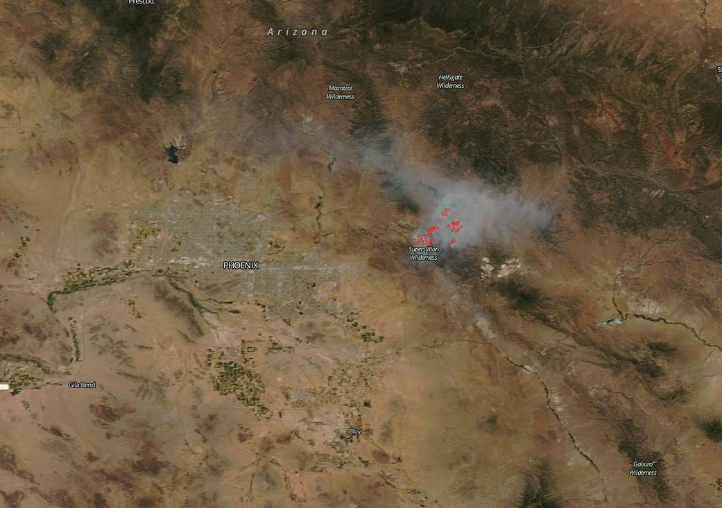
Imagery from NASA’s Aqua satellite revealed plumes of smoke generated from the Woodbury Fire, burning east of Phoenix, Arizona on June 24, 2019.
The Woodbury Fire continues to rage in the Superstition Wilderness of the Tonto National Forest. The fire is located about 5 miles northwest of Superior, Arizona. It is in the jurisdiction of the Tonto National Forest, Arizona State Land and the Arizona-Bureau of Land Management, and National Park Service.
On June 24, the Tonto National Forest website noted several areas of very high or extreme fire danger. Very high areas of danger include Payson and Pleasant Valley. A warning for “Extreme fire danger,” was in effect for the Tonto Basin, Globe and Mesa/Cave Creek area. The USDA Forest Service reported on June 24, the fire covers 96,307 acres and is 25 percent contained.
The MODIS or Moderate Resolution Imaging Spectroradiometer instrument that flies aboard NASA’s Aqua satellite provided a visible image that showed light brown streams of smoke from burning fires were blowing to the northeast. Actively burning areas, detected by MODIS are outlined in red.
For information about evacuations, shelters, livestock and pet shelters call: 928-402-8888. For details on the current operations, visit: https://www.fs.usda.gov/detail/tonto/news-events/?cid=FSEPRD639899
NASA’s Earth Observing System Data and Information System (EOSDIS) Worldview application provides the capability to interactively browse over 700 global, full-resolution satellite imagery layers and then download the underlying data. Many of the available imagery layers are updated within three hours of observation, essentially showing the entire Earth as it looks “right now.” Actively burning fires, detected by thermal bands, are shown as red points and when accompanied by smoke, as in this image, are indicative of fire.
For updates from Inciweb, visit: https://inciweb.nwcg.gov/incident/6382
For updates from the Tonto National Forest on Facebook: www.facebook.com/TontoNationalForest/
Image Courtesy: NASA Worldview, Earth Observing System Data and Information System (EOSDIS).
Caption: Rob Gutro with information from Inciweb.