


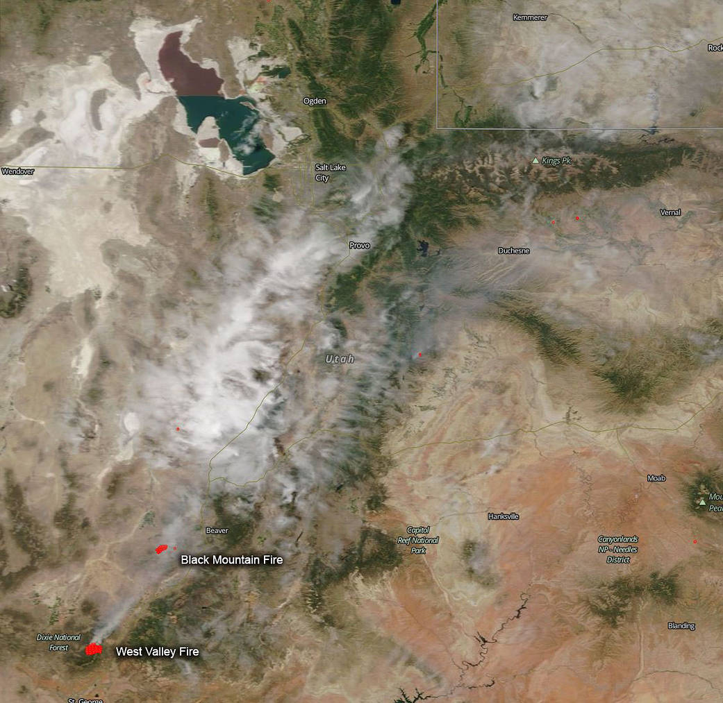
The West Valley Mountain fire located on Pine Valley Mountain and north of the city of St. George, Utah, began on Wednesday, June 27, 2018, and continued to actively burn throughout the day, aided by critical fire weather conditions. On Thursday, the West Valley Fire double in size from 4,700 acres to 7,200 acres overall, according a West Valley Fire information officer. The cause of the fire outbreak is unknown. Firefighters are not getting a break from weather conditions. A red flag warning was issued by the National Weather Service Thursday morning and has been extended until Saturday at midnight. Southwest winds 15 to 25 mph with gusts 30 to 35 mph will shift to gusty northwest winds. The winds combined with relative humidity falling to between 10 and 15 percent in the afternoon through Saturday will create critical fire weather conditions, which will most likely accelerate the spread of the fire.
North of the West Valley Mountain fire is the Black Mountain fire which is located just two miles south of Minersville. This fire has already consumed over 5,000 acres. This fire began on Thursday, June 28, with a vehicle crash. A vehicle drifted out of its lane and overcorrected causing it to roll over several times ending up in dry brush. A spark from the crash began the fire which then spread. The driver sustained only minor injuries. A passerby had called 911 to report the accident and the fire that had begun. Attempts were made to put out the fire by people in area, but the winds were too aggressive and the fire jumped the highway. The fire threatened Minersville but then abruptly changed course although a wind change could cause the track of the fire to head back to town. Utah Fire Info said a local Type 3 Team will takeover fire fighting operations today, June 29, and critical fire weather was expected.
NASA’s Terra satellite captured this image of the fire and smoke blowing from it on June 28, 2018 with the Moderate Resolution Imaging Spectroradiometer, MODIS, instrument. Actively burning areas (hot spots), detected by MODIS’s thermal bands, are outlined in red. Each hot spot is an area where the thermal detectors on the MODIS instrument recognized temperatures higher than background. When accompanied by plumes of smoke, as in this image, such hot spots are diagnostic for fire. NASA image courtesy of the NASA/Goddard Space Flight Center Earth Science Data and Information System (ESDIS) project. Caption by Lynn Jenner with information from local highway and fire officials.