


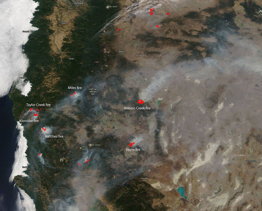
Fires have been breaking out all over the western United States due to weather conditions which favor fire outbreak and copious amounts of very dry fire fuel in timber, grasses, and underbrush. In Oregon there are 15 large ongoing fires and 231,278 acres have been burned. The satellite image above shows several of the larger fires in both Oregon as well as California. California has 10 large fires including the two largest to date, the Ferguson fire and the Mendocino Complex. California has seen 716,276 acres burned this year.
In Oregon, the Taylor Creek and Klondike Fires are burning in the Rogue River-Siskiyou National Forest. Both fires were started by lightning on July 15. These two fires were split into zones on Saturday, Aug. 18. The fires are now referred to as “Taylor Creek and Klondike East Fires,” managed by the Alaska Incident Management Team and the “Klondike West Fire” which is managed by California Interagency Incident Management Team 4. California Interagency was called in to continue with the aggressive fight to fully suppress the fire. That will allow the Alaska Incident Management Team to focus its effort on controlling the southeast corner of the fire that is directly threatening the communities of Selma and Cave Junction. As of the morning of Aug. 20, the Taylor Creek Fire is estimated 52,588 acres and is 79 percent contained. The Klondike Fire is estimated at 72,074 acres and is 28 percent contained.
The Miles Fire is the new name for the fire previously named the Sugar Pine. The Miles Fire and Sugar Pine fire have merged. On Sunday July 15, lightning started hundreds of fires across Southwest Oregon. The Miles fire has currently affected 47,015 and is 38% contained at present. Today some instability will swing into the area with the threat of some isolated showers or a thunderstorm. Continued smoke in the valleys will moderate daytime temperatures but will also continue to affect air quality for local communities.
The Watson Creek fire is currently burning on the Paisley Ranger District of the Fremont-Winema National Forest. It was discovered Wednesday, August 15 at 2:15 p.m. The fire is currently burning in heavy fuels, primarily dead and down lodge pole pine. This fire has burned 25,778 acres. The cause of the blaze is under investigation. There are several closures due to this fire that can be found at this website: https://inciweb.nwcg.gov/incident/article/6153/46264/
In California, right on the Oregon/California line between Happy Camp, CA and Cave Junction, OR is the Natchez fire which has been burning since lightning struck on July 15, 2018. The 697 personnel assigned to the incident are working to implement suppression actions that will most effectively and safely limit fire growth. Currently 20,275 acres have burned and the fire is 70% contained. Fire area closures are in place on the Rogue River-Siskiyou and Klamath National Forests.
The Stone fire began on August 15 with a lightning strike. The current fire size 22,610 acres. Weather concerns for this fire include extremely dry conditions and low humidity. The fire was active last night and fire crews made great progress along the fire edge to control the fire spread and provide structure defense.
NASA’s Earth Observing System Data and Information System (EOSDIS) Worldview application provides the capability to interactively browse over 700 global, full-resolution satellite imagery layers and then download the underlying data. Many of the available imagery layers are updated within three hours of observation, essentially showing the entire Earth as it looks “right now.” This satellite image was collected on August 19, 2018. Actively burning fires, detected by thermal bands, are shown as red points. Image Courtesy : NASA Worldview, Earth Observing System Data and Information System (EOSDIS). Caption: Lynn Jenner with information from Inciweb.