


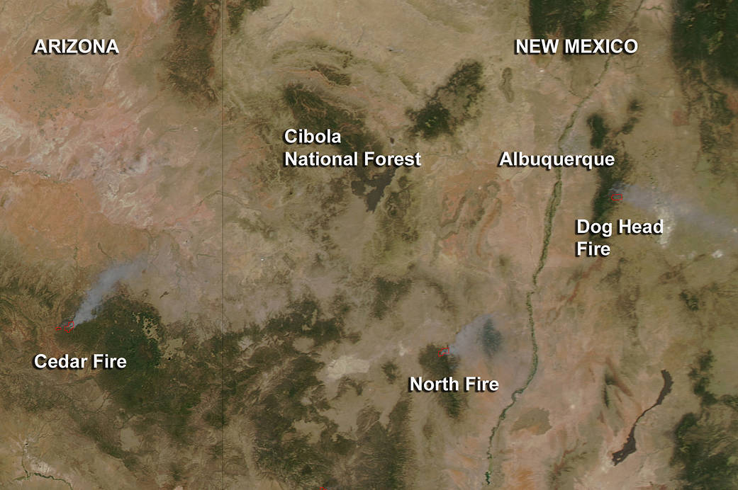
Fires are raging in Arizona and New Mexico, and NASA’s Terra satellite captured an image of smoke and detected heat from several of them on June 17.
The Moderate Resolution Imaging Spectroradiometer (MODIS) instrument that flies onboard NASA’s Aqua satellite captured an image of smoke from the Cedar Fire in Arizona and the Dog Head and North fires in New Mexico on June 17, 2016 at 2050 UTC (4:50 p.m. EDT). The large red pixels are the heat signature from the fire as detected by MODIS. Smoke appears as a light brown color.
The Cedar Fire in Arizona began on June 15, 2016. The circumstances surrounding how it began are still under investigation. For the NASA June 20 update, visit: https://www.nasa.gov/image-feature/goddard/2016/cedar-fire-in-arizona-continues-to-spread
The Dog Head Fire, located southeast of Albuquerque, New Mexico, began on Tuesday, June 14th, 2016 at approximately 11 a.m. MDT, about 6 miles northwest of Tajique, New Mexico. According to Inciweb, an interagency all-risk incident information management system that coordinates with federal, state and local agencies to manage wildfires, the Dog Head Fire covered 17,944 acres as of June 20.
South of Albuquerque lies the North Fire. Inciweb reported that the lightning-caused fire started on May 21 and is located in the San Mateo Mountains about 25 miles southwest of Magdalena, New Mexico. The North Fire grew in size on June 19 and is now covering 36,110 acres and is at 30% containment.
For updates on all fires, visit the Inciweb website: http://inciweb.nwcg.gov.
NASA image courtesy Jeff Schmaltz LANCE/EOSDIS MODIS Rapid Response Team, GSFC. Caption by Rob Gutro with information from Inciweb.