


NASA Sees Post-Patricia Moisture, Winds Stalking the Mid-Atlantic
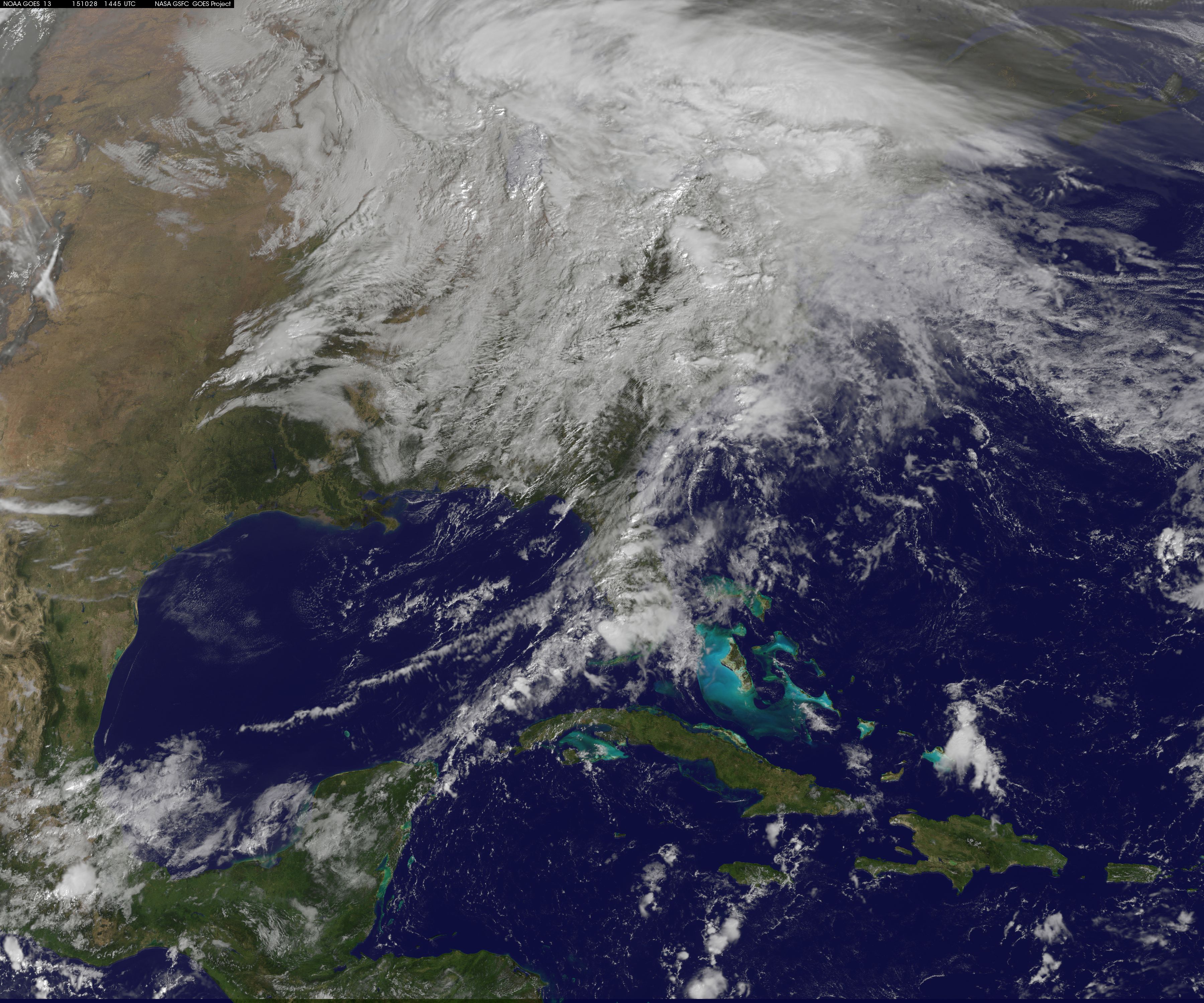
The remnant moisture from what was once Hurricane Patricia and moisture from the Gulf of Mexico were being transported north by a trough of low pressure over Wisconsin. The clouds and moisture were streaming into the Eastern third of the U.S. on October 28, 2015. The hybrid system was generating windy conditions which were seen from NASA’s RapidScat instrument, while NOAA’s GOES-East satellite captured an image of the impressive and sizeable cloud cover.
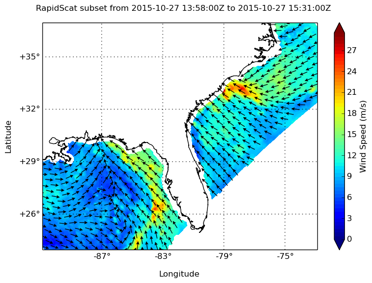
On Oct. 27, the RapidScat instrument aboard the International Space Station measured surface winds over the Gulf of Mexico and off the U.S. Atlantic coast. At 11 a.m. EDT strongest winds were along Florida’s west coast near 18 meters per second/40.2 mph/ 64.8 kph. Stronger winds up to 27 meters per second/60.4 mph/97.2 kph were seen off the coast of the Carolinas. RapidScat measures wind speed at the surface which is always lower than speeds at higher altitude.
NOAA’s GOES-East satellite captured an image of the clouds associated with the large system on October 28, 2015 at 1315 UTC (9:15 a.m. EDT). The low pressure center was located over southern Wisconsin, and the associated cold front draped from the low, south through the Tennessee Valley and over the Gulf of Mexico near the western Florida Panhandle. To the east of the cold front, was a warm front moving north through the Carolinas, bringing up more moisture and warm temperatures to the Mid-Atlantic.
On October 28, 2015, The National Weather Service’s Weather Prediction Center (NPC) said that large upper-level trough (elongated area) of low pressure anchoring the Great Plains/Mississippi Valley region will continue to transport abundant moisture into the eastern third of the country. NPC said “This enhanced Gulf moisture combined with sufficient lift from embedded disturbances within the upper trough will support widespread rainfall over the northeastern United States. The WPC precipitation forecast indicates the heaviest amounts should be along the I-95 corridor stretching from the Upper Mid-Atlantic into New England. 2 to 3 inches of rainfall are possible through Friday morning across these regions.”
On October 28, 2015, the National Weather Service’s Weather Prediction Center expected widespread rainfall across much of the eastern third of the U.S. as the frontal system moves across the region. The heaviest rainfall will be across the Mid-Atlantic and New England, where 2 to 3 inches of rainfall is expected through early Friday, October 30. High winds are also possible from the Appalachians to New England.”
The low pressure area is forecast to move into eastern Canada by October 30, and the associated cold front is expected to be off-shore in the Atlantic at that time, with another cold-front behind it, along the U.S. East coast. For updated forecasts, visit the NWS at www.weather.gov.
Rob Gutro
NASA’s Goddard Space Flight Center
Oct. 27, 2015 – NASA Looks at Winds, Cloud Extent of Patricia’s Remnant Hybrid System
NASA’s RapidScat analyzed the winds in the Gulf of Mexico that were associated with the hybrid storm the included the remnants of former Eastern Pacific Ocean Hurricane Patricia. NOAA’s GOES-East satellite showed the extent of the hybrid system’s cloud cover over the southeastern U.S. on October 27.
Patricia’s remnants merged with an upper-level low pressure area after it made landfall, and that system has plagued the U.S. Gulf coast states with heavy rains and gusty winds since Sunday, Oct. 25.
NASA’s RapidScat instrument flies aboard the International Space Station and can detect the speed and direction of surface winds over open waters. “On October 26 at 1500 UTC (11 a.m. EDT) RapidScat got another view of the Gulf of Mexico which showed moderately high winds over a very broad area as well as a low pressure area centered over Louisiana,” said Doug Tyler of the RapidScat team at NASA’s Jet Propulsion Laboratory, Pasadena, California.

RapidScat saw a small area of strongest winds over the Gulf of Mexico, just south of the Florida Panhandle at 27 meters per second (60.4 mph/97.2 kph). Near the center of the low pressure area, RapidScat measured a large area of sustained winds near 18 meters per second (40 mph/64 kph) over the Gulf of Mexico, and just south of Louisiana.
On October 27, the National Weather Service discussion said “The area of low pressure that brought heavy rain to the Gulf Coast will begin moving northward on Tuesday, bringing rain to the Ohio Valley and Appalachians before moving toward the Northeast on Wednesday. Rainfall amounts will generally be less than those across the southern Plains and Gulf Coast over the past few days.”
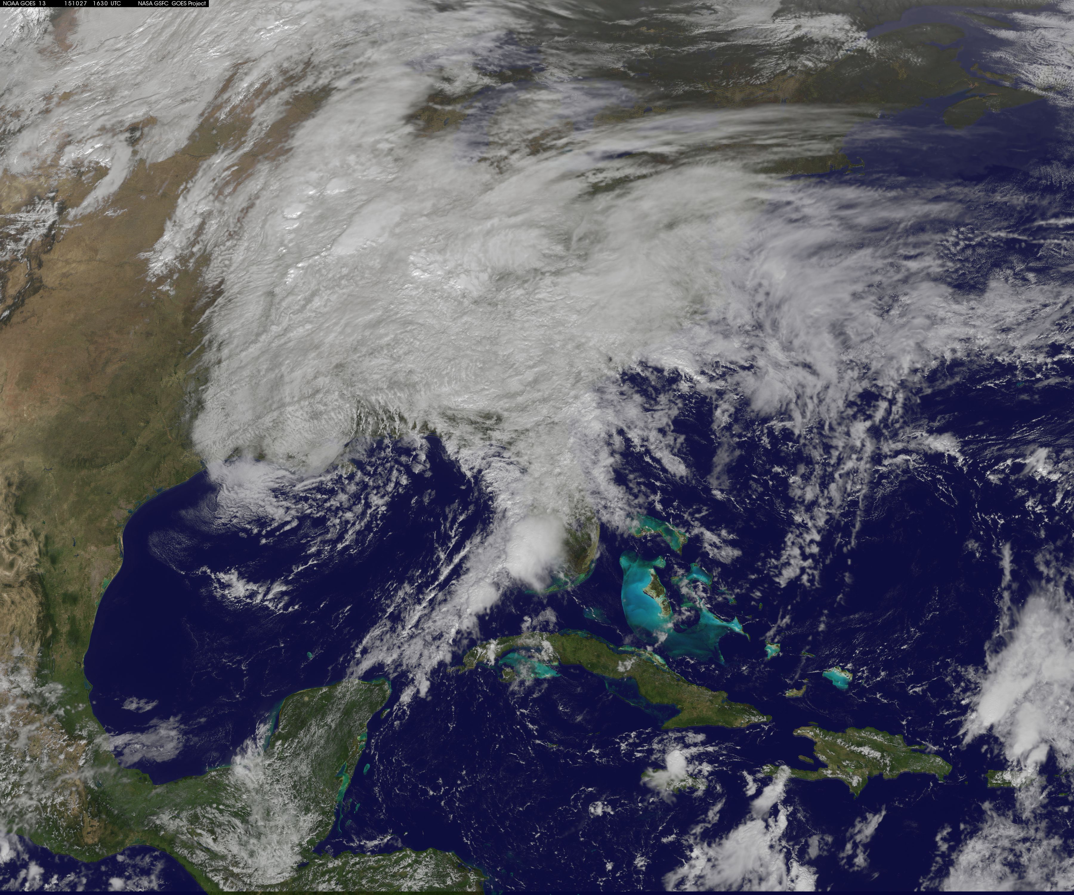
A visible image of the clouds associated with Patricia-hybrid system were seen in a visible image from NOAA’s GOES-East satellite on October 27, 2015 at 1630 UTC (12:30 p.m. EDT). Clouds associated with the system stretch from Florida west to Louisiana and over the Mississippi and Tennessee Valleys north to the Mid-Atlantic States. NOAA manages the GOES series of satellites, and NASA/NOAA’s GOES Project at NASA’s Goddard Space Flight Center in Greenbelt, Maryland creates images and animations using the satellite data.
At 10 a.m. EDT the surface low with a central pressure of 1006 millibars was located about 60 miles northwest of New Orleans, Louisiana. The National Weather Service explained that an occluded front extended from the low pressure center and was moving north through southern Mississippi and Alabama. Also, there was a cold front extending from the east-central Gulf of Mexico and a quasi-stationary frontal boundary that stretched across the Alabama/Florida border and Georgia/Florida border and into the western Atlantic Ocean
The GOES image showed the clouds associated with the tropical moisture that continued to stream into the southeastern states ahead of an upper level system located in the Deep South. For forecast updates, visit the National Weather Service: www.weather.gov.
Rob Gutro
NASA’s Goddard Space Flight Center
Oct. 26, 2015 – NASA Tracks Hurricane Patricia’s Remnants Through Gulf States
As the remnants of Hurricane Patricia continue to generate flooding rainfall as it moved through the Gulf Coast states on October 26, NASA and NOAA satellites provided data on the storm.
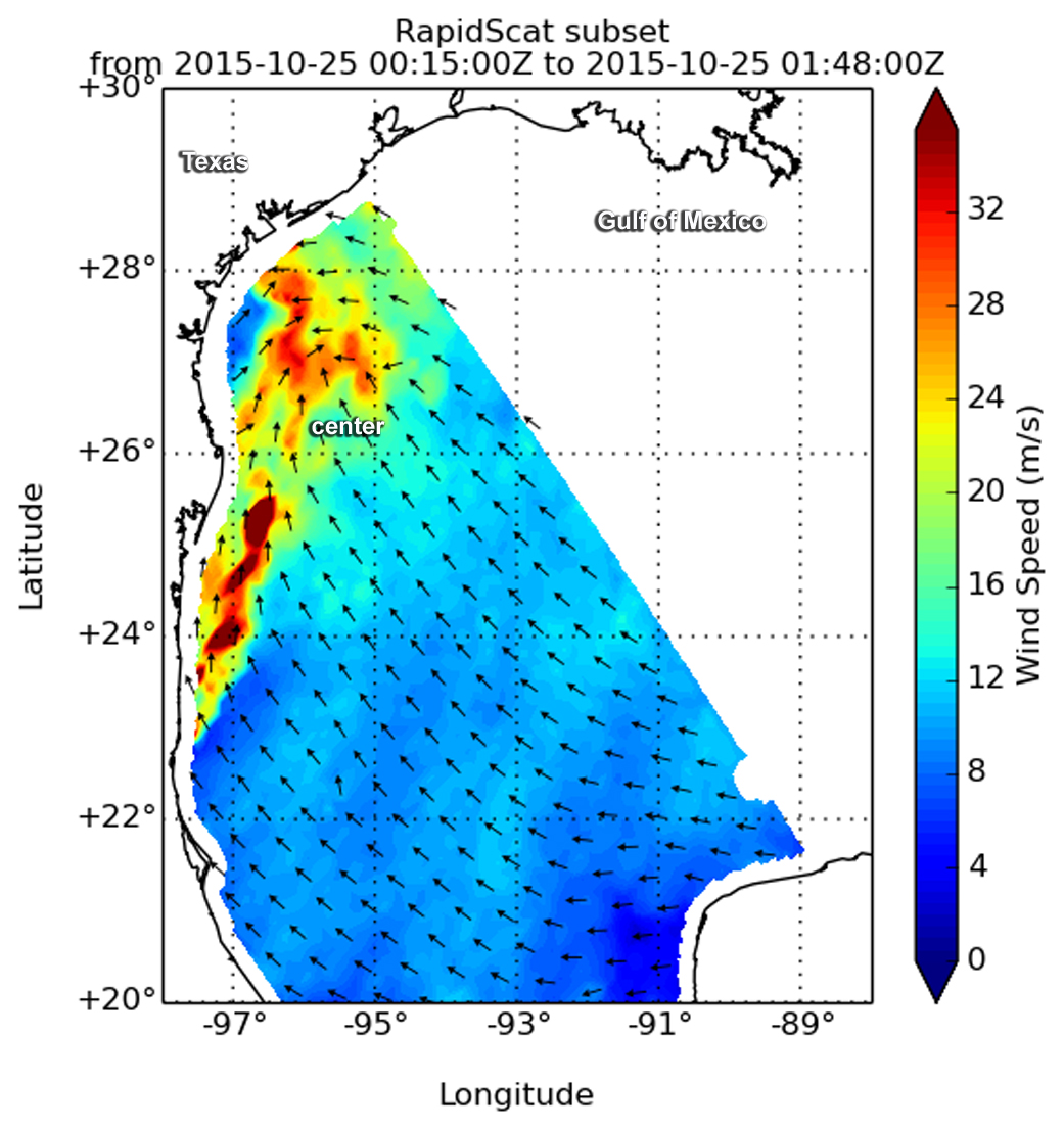
RapidScat gathered wind speed and direction data on the remnants of Hurricane Patricia on Oct. 24 at 9 p.m. EDT. RapidScat is an instrument that flies aboard the International Space Station and measures surface winds over open waters of oceans. RapidScat showed that the strongest sustained winds were near 36 meters per second/70 knots/80.5 mph/129.6 kph north and west of the center, which RapidScat showed over the western Gulf of Mexico.” RapidScat caught a view of the Gulf of Mexico where gulf wind speeds are very high just adjacent to the flooding in Texas,” said Doug Tyler of the RapidScat team at NASA’s Jet Propulsion Laboratory in Pasadena, California.
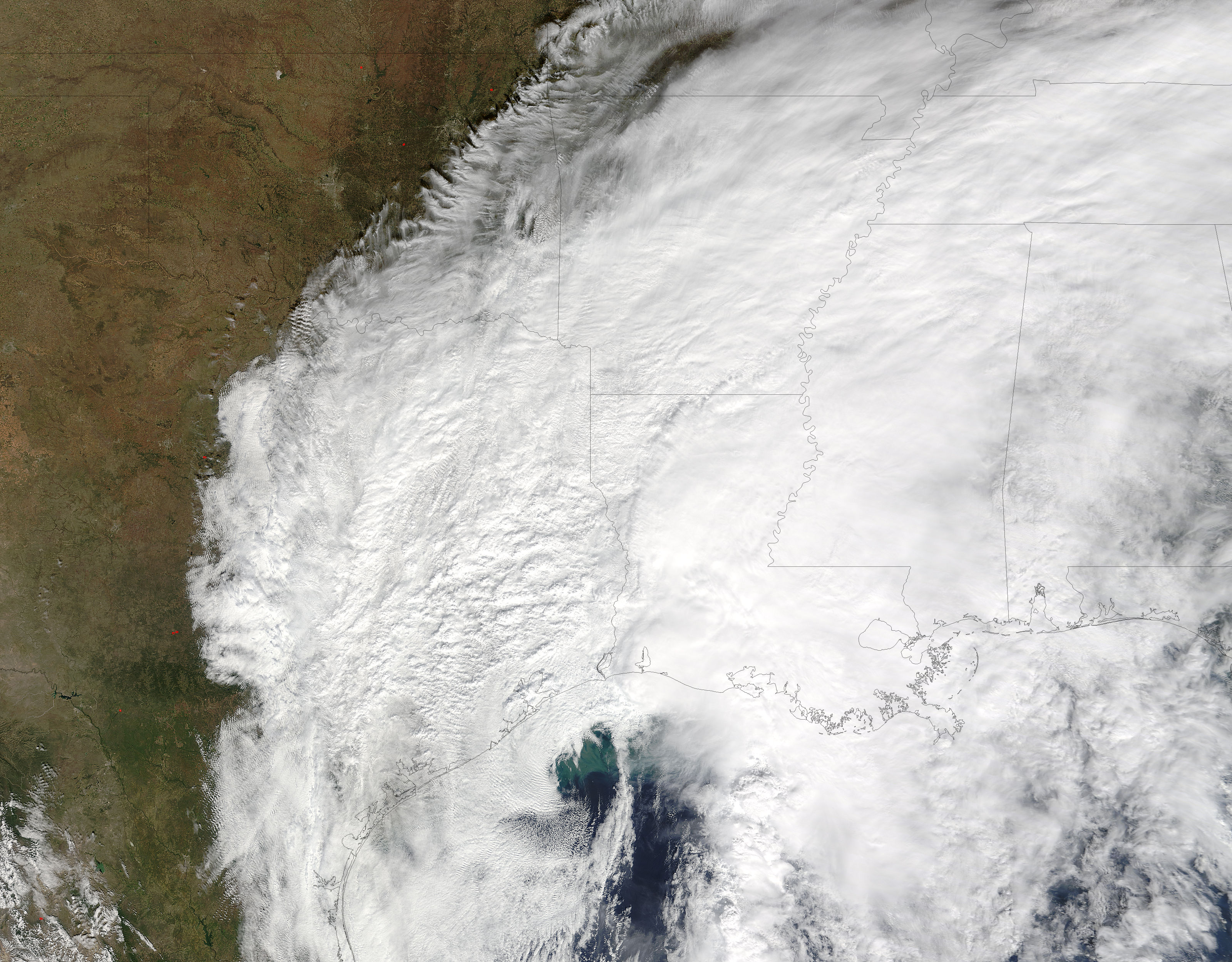
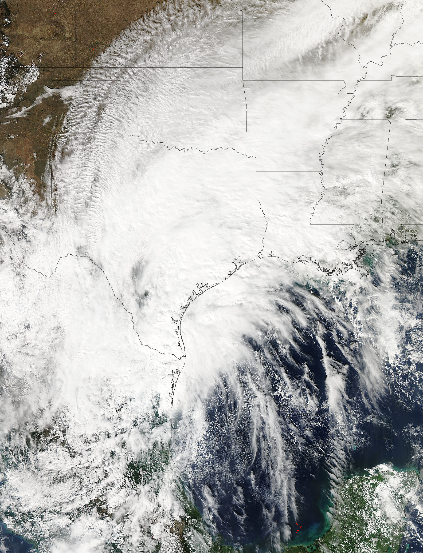
On Oct. 25 at 17:15 UTC (1:15 p.m. EDT) the Moderate Resolution Imaging Spectroradiometer that flies aboard NASA’s Terra satellite saw the remnants of Hurricane Patricia over Texas, Louisiana and Mississippi. The visible image showed the center over the northwestern Gulf of Mexico and powerful thunderstorms over the Gulf States. The image was created by the NASA MODIS Rapid Response Team at NASA’s Goddard Space Flight Center in Greenbelt Maryland.
Credits: NASA/NOAA GOES Project
A 21 second animation of infrared and visible imagery from NOAA’s GOES-East satellite over the period of Oct. 24 to 26 showed the remnants of Hurricane Patricia wrapped into a low pressure area move through the Gulf of Mexico and Gulf Coast States. On October 24, strong thunderstorms were seen developing over the Texas east coast and then over eastern Texas, Louisiana and Mississippi as it moved into the Mississippi Valley. The animation was created by the NASA/NOAA GOES Project at NASA Goddard.
NOAA’s National Weather Service said on October 26, that “the system that brought heavy rainfall and flash flooding to parts of the southern Plains and western Gulf Coast over the past several days continues to push eastward, with the greatest potential for heavy rain and flash flooding on Monday across parts of the lower Mississippi Valley and Southeast. There is also a Marginal Risk for severe thunderstorms across the region.”
For updated forecasts, visit the National Weather Service website at: www.weather.gov.
Rob Gutro
NASA’s Goddard Space Flight Center
Oct. 25, 2015 – NASA Sees Patricia’s Remnants Combine With Storm System Over Texas
Patricia, the most powerful hurricane on record in the Western Hemisphere, quickly lost power as it moved over Mexico. As the remnants moved to the northeast, NASA and JAXA’s GPM satellite and NASA’s Aqua satellite observed the clouds, showers and moisture as it combined with an upper-level low pressure system.
After landfall along the southwestern coast of Mexico on Friday night, October 23, Patricia weakened to a depression quickly and then a remnant low pressure area that had combined with a low pressure area over Texas to drop very heavy rainfall in the state.
The MODIS instrument aboard NASA’s Aqua satellite captured a visible image of clouds associated with Tropical Depression Patricia over Texas, Louisiana, Oklahoma Arkansas and Mississippi on Oct. 24 at 1935 UTC (3:35 p.m. EDT).
On Sunday October 25, 2015 eastern Texas, Louisiana and Mississippi were also warned of flooding as extreme rainfall moved eastward along the Gulf Coast.
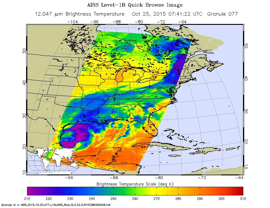
At 3:41 a.m. EDT (0741 UTC) on Sunday, October 25, infrared imagery from the Atmospheric Infrared Sounder instrument aboard NASA’s Aqua satellite showed the remnants over the western Gulf of Mexico. The remnants contained thunderstorms with very cold cloud top temperatures in excess of minus 63 degrees Fahrenheit (minus 53 degrees Celsius) indicating high, powerful storms with the capability to generate heavy rainfall.
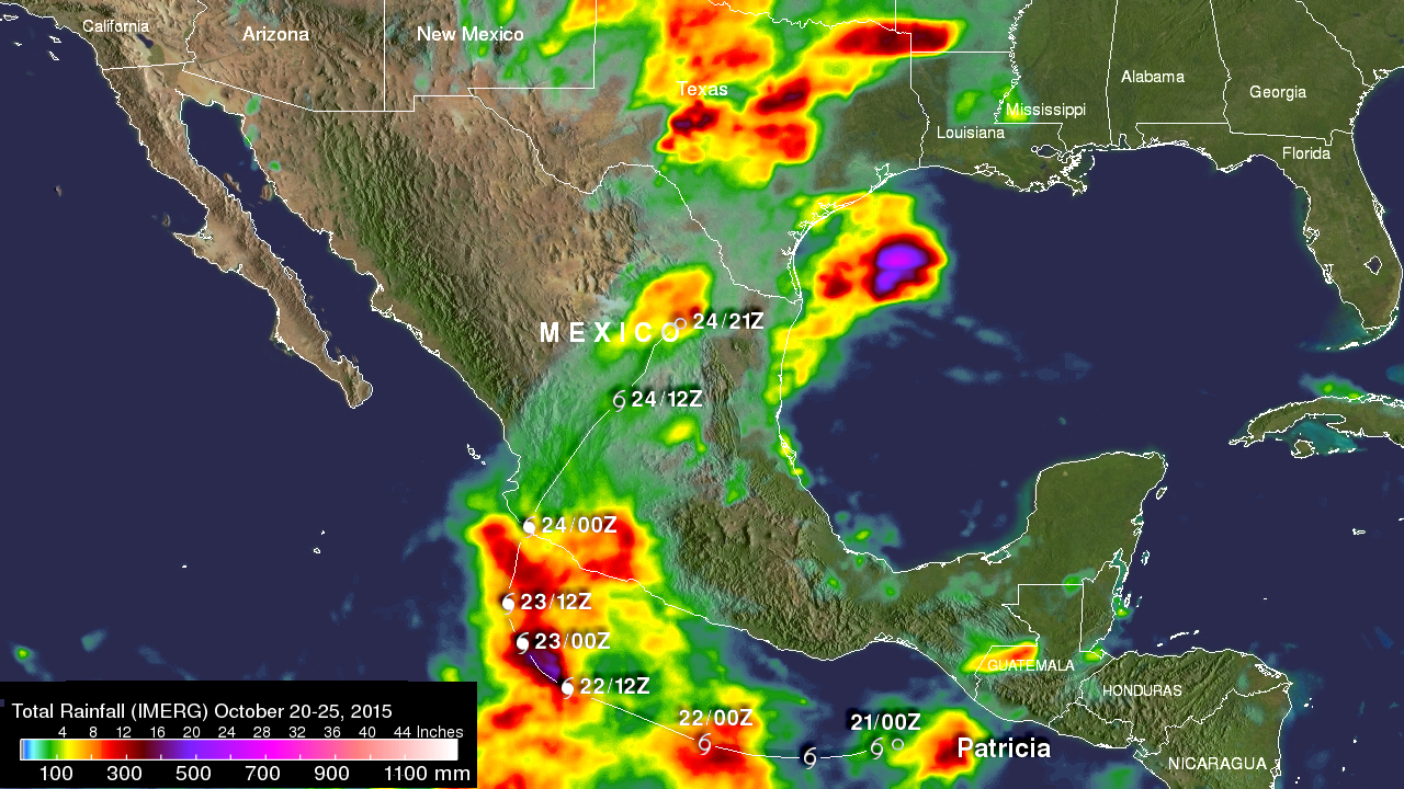
Rainfall data from the Global Precipitation Measurement or GPM core satellite was used to create a map of Patricia’s precipitation. The GPM satellite, managed by both NASA and the Japan Aerospace Exploration Agency, showed Patricia’s highest rainfall totals over 409 mm (16.1 inches) from Oct. 20-25. Rain totals of over 203 mm (8 inches) were located where Patricia made landfall. During that time, GPM saw a larger rainfall (not associated with Patricia) in the Gulf of Mexico where over 507 mm (almost 20 inches) of rain fell.
NOAA’s National Weather Service (NWS) issued Flash Flood Watches along the Gulf coast on Sunday, October 25 for eastern Texas, most of Louisiana, southern Mississippi, southern Alabama and the panhandle of Florida.
The NWS office at Houston/Galveston noted a new record daily maximum rainfall at 2:40 a.m. CDT on Sunday, October 25. The record was set at the Houston Intercontinental airport where 5.54 inches fell on October 24. That broke the previous record of 2.13 inches set 66 years ago in 1949.
NWS noted that the heaviest rain is expected on Sunday, October 25 across southeastern Texas, Louisiana and parts of Mississippi before moving into the central Gulf on Monday, October 26.
Rob Gutro
NASA’s Goddard Space Flight Center
Oct. 24, 2015 – NASA Analyzes Historic Hurricane Patricia’s Landfall, Heavy Rains, and more
Hurricane Patricia made landfall at 7:15 p.m. EDT on Friday, October 24, 2015 along the southwestern coast of Mexico and less than 16 hours later it had weakened to a tropical depression but continued dropping large amounts of rain. NASA’s Aqua satellite captured Patricia making landfall, while the Global Precipitation Measurement mission (GPM) core satellite added up Patricia’s high rain totals.
Satellite imagery and surface observations on October 24 at 11 a.m. EDT indicated that the mid- to upper-level center is located northeast of the center of circulation at the surface. In addition, there is little organized convection (developing thunderstorms) associated with the cyclone.
Landfall as a Category 5 Hurricane
Satellite images indicated that the center of the eye of Patricia made landfall at approximately 7:15 p.m. EDT/6:15 p.m. CDT/2315 UTC on Friday, October 23 along the coast of southwestern Mexico near Cuixmal. It was 55 miles (85 km) west-northwest of Manzanillo, Mexico. That was also about 55 miles (85 km) west-northwest of Manzanillo, Mexico. The maximum winds were estimated to be 165 mph (270 kph) at the time of landfall. That means the sustained winds had dropped by 35 mph from 200 mph just before landfall. Regardless, Patricia was still a Category 5 hurricane on the Saffir-Simpson Wind Scale at landfall.
Adding Up Patricia’s Heavy Rainfall from Space
Data from NASA’s Integrated Multi-satellitE Retrievals for GPM (IMERG) were used to estimate the amount of rain that fell during the short time period when hurricane Patricia explosively developed and circled back to hit Mexico. This analysis included data collected from October 20-24, 2015 and showed rainfall for the East Pacific, Mexico and the surrounding region. This preliminary rainfall total analysis showed that by early October 24, the heaviest rain from Patricia fell over the open waters of the Eastern Pacific. Rainfall totals there were found to be over 409 mm (16.1 inches). Rain totals of over 203 mm (8 inches) were located where Patricia made landfall.
Credits: NASA/JAXA/SSAI, Hal Pierce
An even rainfall greater total, that was not associated with Patricia, was located in the Gulf Of Mexico where over 507 mm (almost 20 inches) of rain fell during this short period.
GPM is a joint mission between NASA and the Japanese space agency JAXA.
Location and Statistics on Saturday, October 24
According to the National Hurricane Center, at 11 a.m. EDT (1500 UTC) on Saturday, October 24, the center of Tropical Depression Patricia was located near latitude 23.9 North, longitude 101.6 West. That’s about 95 miles (155 km) northeast of Zacatecas, Mexico. Maximum sustained winds had decreased to near 35 mph (55 kph) with higher gusts.
The depression was moving toward the northeast near 24 mph (39 kph) and this motion is expected to continue through tonight, October 24. On the forecast track, the center of Patricia is forecast to move across central and northeastern Mexico on Saturday, October 24. The estimated minimum central pressure is 1002 millibars.
How Patricia Made History
Research meteorologist Steve Lang and NASA’s Goddard Space Flight Center in Greenbelt, Maryland explained how Hurricane Patricia made history in a number of ways.
“Hurricane Patricia made history early Friday morning, October 23 when it became the strongest storm ever recorded in the Western Hemisphere with maximum sustained winds reported at 200 mph by the National Hurricane Center (NHC) at 4:00 a.m. CDT (5 a.m. EDT) October 23, based on Hurricane Hunter aircraft measurements collected in the eye of the storm,” Lang said.
“Patricia’s estimated minimum central pressure of 880 millibars was also the lowest ever recorded in the Western Hemisphere, besting Hurricane Wilma’s 882 millibars in 2005 and Hurricane Gilbert’s 888 millibars in 1988; those storms both had maximum sustained winds of 185 mph. For comparison, Hurricane Katrina, the costliest storm in U.S. history, had a minimum central pressure of 902 millibars and peak sustained winds of 175 mph while Super typhoon Haiyan, which devastated the central Philippines in 2013, had peak sustained winds of 195 mph, but those were estimated from satellite and thus less precise. The lowest pressure ever recorded in a tropical cyclone was 870 millibars in Typhoon Tip west of Guam in the western Pacific back in 1979. Its maximum sustained winds were measured by aircraft at 190 mph.
Not only is Patricia historic in terms of its overall intensity, it is also one of the fastest strengthening storms on record. At 4 a.m. CDT on the morning of Thursday October 22, Patricia was a run-of-the-mill Category 1 hurricane with a minimum central pressure of 980 millibars and maximum sustained winds of 85 mph. Twenty-four hours later at 4 a.m. CDT on the October 23, after undergoing what is known as a rapid intensification cycle, the pressure had fallen 100 millibars to 880 millibars, and the peak sustained winds had increased by 115 mph to 200 mph. This rate of wind intensification supercedes the previous record rate in the eastern Pacific of ~100 mph (85 knots) in 24 hours set by Hurricane Linda back in 1997, which was until Patricia the strongest hurricane on record in the East Pacific, and Wilma’s increase of 105 mph in 24 hours in the western Caribbean. Patricia’s 100 millibars pressure fall in 24 hours well exceeds Linda’s 81 millibars in 24 hours and just exceeds Hurricane Wilma’s 97 millibar fall in 24 hours.”
Rapid Intensification
Such rapid intensification indicates that the environmental conditions for the storm are ideal, namely very little wind shear, no dry air intruding into the storm, and warm sea surface temperatures, in this case very warm sea surface temperatures, which provide the fuel for such storms.
Lang said that the current 2015 El Nino is setting up to be one of the strongest on record. As a result, sea surface temperatures are well above average over a vast area of the equatorial East Pacific. However, El Nino is not the only story. For about the past two years, “the Blob” has also been lurking along the West Coast of North America. This large mass of above-normal sea surface temperatures extends from the Bering Sea all the way down to the Pacific Coast of Mexico and is likely part of the Pacific-Decadal Oscillation, akin to the El Nino/Southern Oscillation or ENSO, it goes through warm and cold phases. The PDO is currently in a warm phase, which is manifest by above-normal sea surface temperatures along the Pacific Coast of North America. The juxtaposition of these two large masses of warm water has contributed to the ideal conditions for the development and rapid intensification of Hurricane Patricia southwest of Mexico.
What’s Next for Patricia?
NHC forecasters said that Patricia is expected to degenerate to a remnant low pressure area later today or tonight over northeastern Mexico. However, the abundant moisture that this former Category 5 hurricane contains will keep moving.
Forecaster Beven at NHC noted in the 11 a.m. Discussion “Patricia is expected to produce total rainfall accumulations of 8 to 12 inches, with isolated maximum amounts of 20 inches, over the Mexican states of Nayarit, Jalisco, Colima, Michoacan, and Guerrero through Saturday. In addition, the heavy rain threat ahead of Patricia or its remnants will increase Saturday across northeast Mexico into coastal sections of Texas.”
Patricia and Another System
Over the weekend the remnants of Patricia are also expected to add to the extreme rainfall in Texas. Rainfall from a stalled front that has been causing flooding in northern and central Texas will be combined with Patricia’s remnants in southern Texas.
Rob Gutro / Steve Lang
NASA’s Goddard Space Flight Center
Oct. 23, 2015 – Update #3 – NASA Analyzes Record-Breaking Hurricane Patricia
NASA satellites and instruments have been monitoring the record-breaking Hurricane Patricia as it rapidly intensified off the southwestern coast of Mexico on October 23. NASA-NOAA’s Suomi NPP saw frigid cloud top temperatures, NOAA’s GOES-West satellite provided imagery and animations that showed the extent of the storm, NASA’s Terra satellite provided visible data, and the RapidScat instrument aboard the International Space Station measured its surface winds.

Suomi NPP Satellite Sees Frigid High Clouds
When NASA-NOAA’s Suomi NPP satellite passed over Patricia on October 23 at 5:20 a.m. EDT the Visible Infrared Imaging Radiometer Suite or VIIRS instrument that flies aboard Suomi NPP looked at the storm in infrared light. “Cloud top temperatures of thunderstorms around the eyewall were between 180K (-135.7F/ -93.1C) and 190 Kelvin (-117.7F/ -83.1C),” said William Straka III of the University of Wisconsin, Madison. “Then, as you go into the eye itself, it gets warmer.”
The higher the cloud tops, the colder they are as temperatures get colder with altitude in the troposphere. Storms with cloud top temperatures that cold have the capability of generating heavy rainfall.
Credits: NASA/NOAA GOES Project
GOES Satellite Animation Shows Rapid Intensification
On October 22, Patricia was a Category one hurricane. By 8 a.m. EDT on October 23, 2015, the National Hurricane Center reported Patricia became the strongest eastern north pacific hurricane on record with sustained winds near 200 mph.
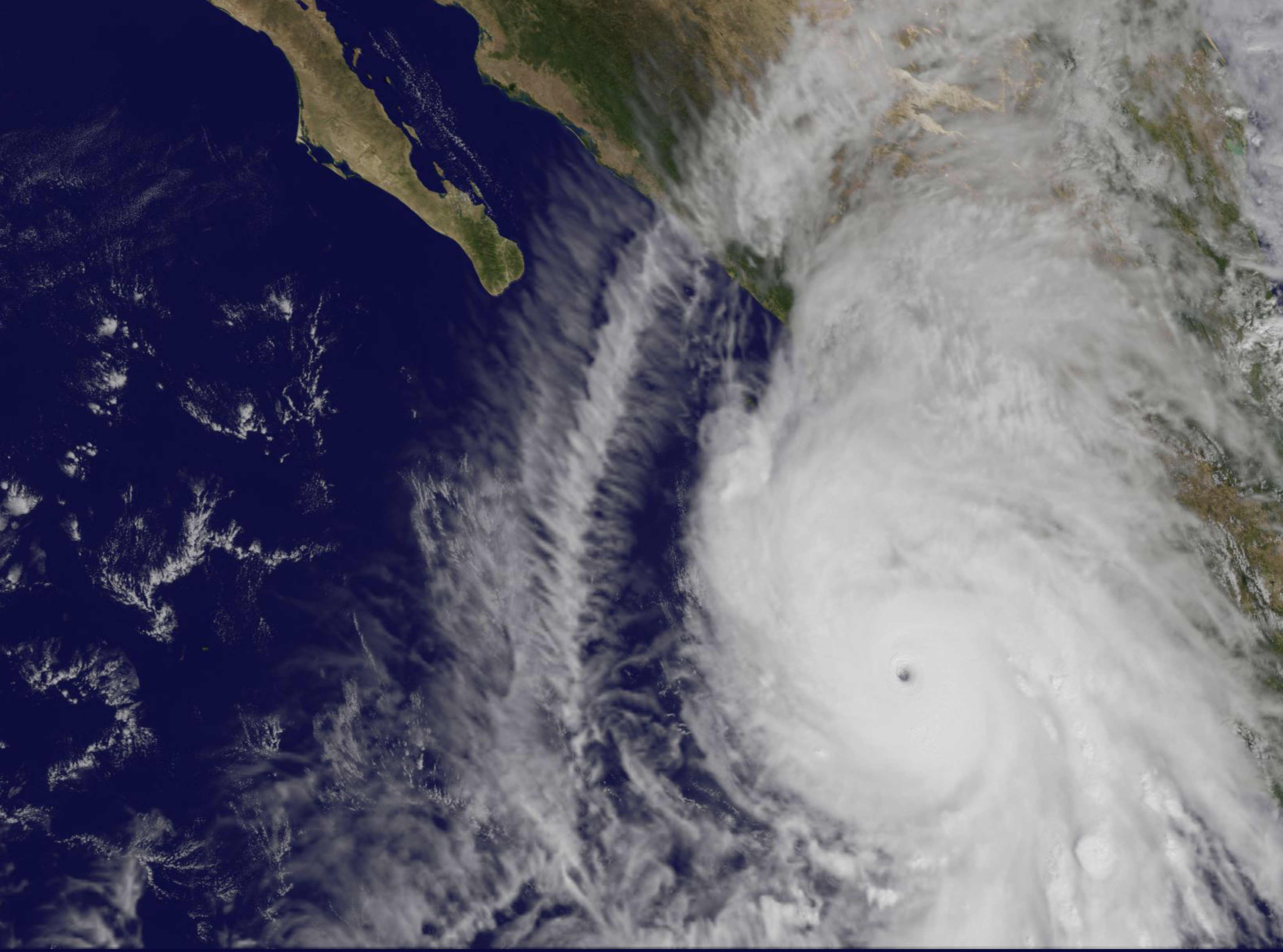
An animation of images captured from October 20 to 23 from NOAA’s GOES-West satellite showed Hurricane Patricia intensify within 24 hours and develop a clear eye near the coast of western Mexico. The animation was created at NASA/NOAA GOES Project at NASA’s Goddard Space Flight Center, Greenbelt, Maryland.
NASA’s Terra Satellite Sees Northeastern Quadrant Already Over Mexico
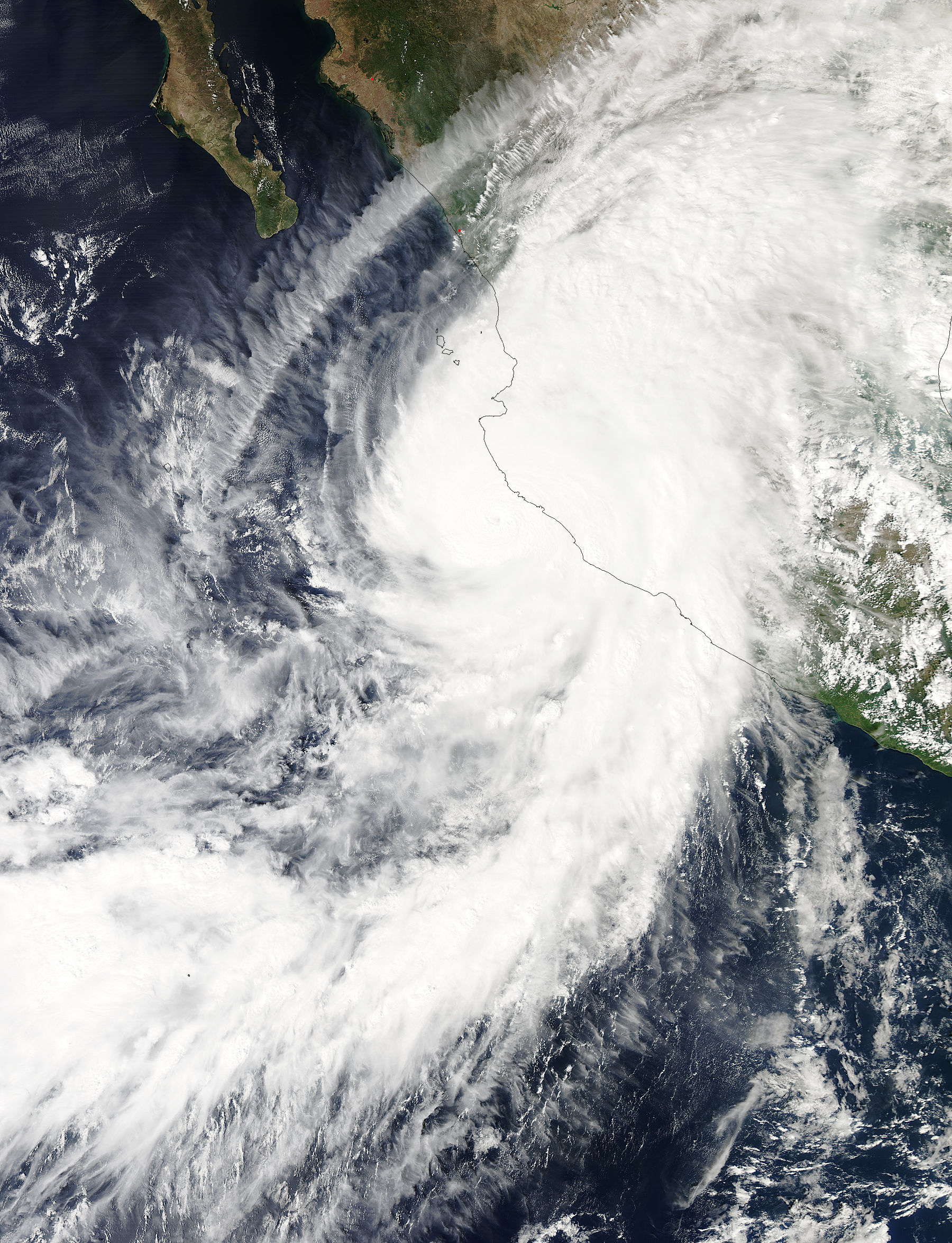
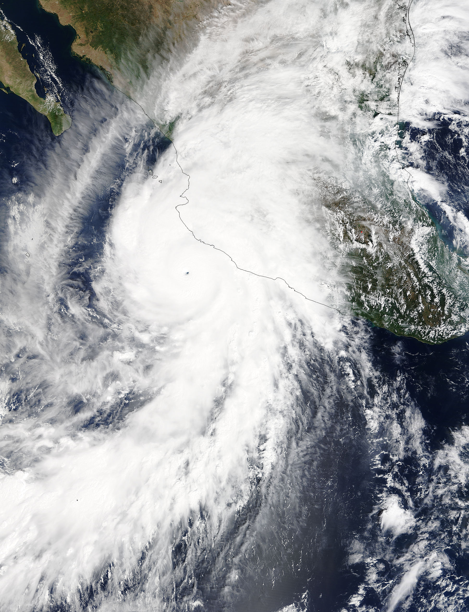
On Oct. 23 at 17:30 UTC (1:30 p.m. EDT) the Moderate Resolution Imaging Spectroradiometer instrument aboard NASA’s Terra satellite saw the eastern quadrant of Hurricane Patricia over Mexico and the storm’s pinhole eye.
Watches and Warnings on October 23, 2015
A Hurricane Warning is in effect from San Blas to Punta San Telmo and a Hurricane Watch is in effect from east of Punta San Telmo to Lazaro Cardenas. A Tropical Storm Warning is in effect from east of Punta San Telmo to Lazaro Cardenas and north of San Blas to El Roblito.
Two Records Broken
The National Hurricane Center reported that Patricia is the strongest hurricane on record in the National Hurricane Center’s area of responsibility (AOR) which includes the Atlantic and the eastern North Pacific basins. The minimum central pressure estimated from the aircraft data, 880 millibars, is the lowest ever for our AOR. The National Hurricane Center noted “It seems incredible that even more strengthening could occur before landfall later today [October 23]. The official forecast shows only a little more strengthening before landfall.”
Status of Hurricane Patricia on October 23 at 2 p.m. EDT
At 2 p.m. EDT (1800 UTC) on October 23, the center of Hurricane Patricia was located near latitude 18.2 North, longitude 105.3 West. Patricia was moving toward the north near 12 mph (19 kph). On the forecast track, the center of Patricia should cross the coast in the hurricane warning area during the next several hours. After landfall, the center of Patricia is expected to move quickly north-northeastward across western and northern Mexico.
Reports from a NOAA Hurricane Hunter aircraft indicate that maximum sustained winds remain near 200 mph (325 kph) with higher gusts. Patricia is a category 5 hurricane on the Saffir-Simpson Hurricane
Wind Scale. Patricia is expected to remain an extremely dangerous category 5 hurricane through landfall. After landfall, Patricia is forecast to rapidly weaken over the mountains of Mexico. Hurricane force winds extend outward up to 35 miles (55 km) from the center and tropical storm force winds extend outward up to 175 miles (280 km). The minimum central pressure estimated from the NOAA aircraft data was 879 millibars.
Landfall Expected at Night, October 23/Early October 24 as a Category 5
Forecaster Beven of the National Hurricane Center stated in a discussion that Patricia is expected to make landfall as a Category 5 hurricane in southwestern Mexico in less than 12 hours. After landfall, a combination of the mountainous terrain of Mexico and increasing shear should cause the cyclone to rapidly weaken, with the system likely to dissipate completely after 36 hours.
Despite dissipation, the National Hurricane Center said that development of another low pressure area is expected to draw significant amounts of moisture from Patricia’s remnants, and could result in locally heavy rainfall over portions of the northwestern Gulf of Mexico coastal area within the next few days.
For updated forecasts, watches and warnings, visit: www.nhc.noaa.gov.
Rob Gutro
NASA’s Goddard Space Flight Center
Oct. 23, 2015 – Update #2 – Hurricane Patricia Seen From the International Space Station
Credits: NASA
Oct. 23, 2015 – Update #1 – NASA-NOAA’s Suomi NPP Satellite Sees Record-Breaking Hurricane Patricia
At 8 a.m. EDT on October 23, 2015, the National Hurricane Center said that Hurricane Patricia had grown into a monster hurricane. In fact, it is the strongest eastern north pacific hurricane on record. NASA-NOAA’s Suomi NPP satellite analyzed the temperatures and structure within the storm as it passed overhead.
On October 23, a Hurricane Warning was in effect from San Blas to Punta San Telmo. A Hurricane Watch was in effect from east of Punta San Telmo to Lazaro Cardenas and a Tropical Storm Warning was in effect from east of Punta San Telmo to Lazaro Cardenas.
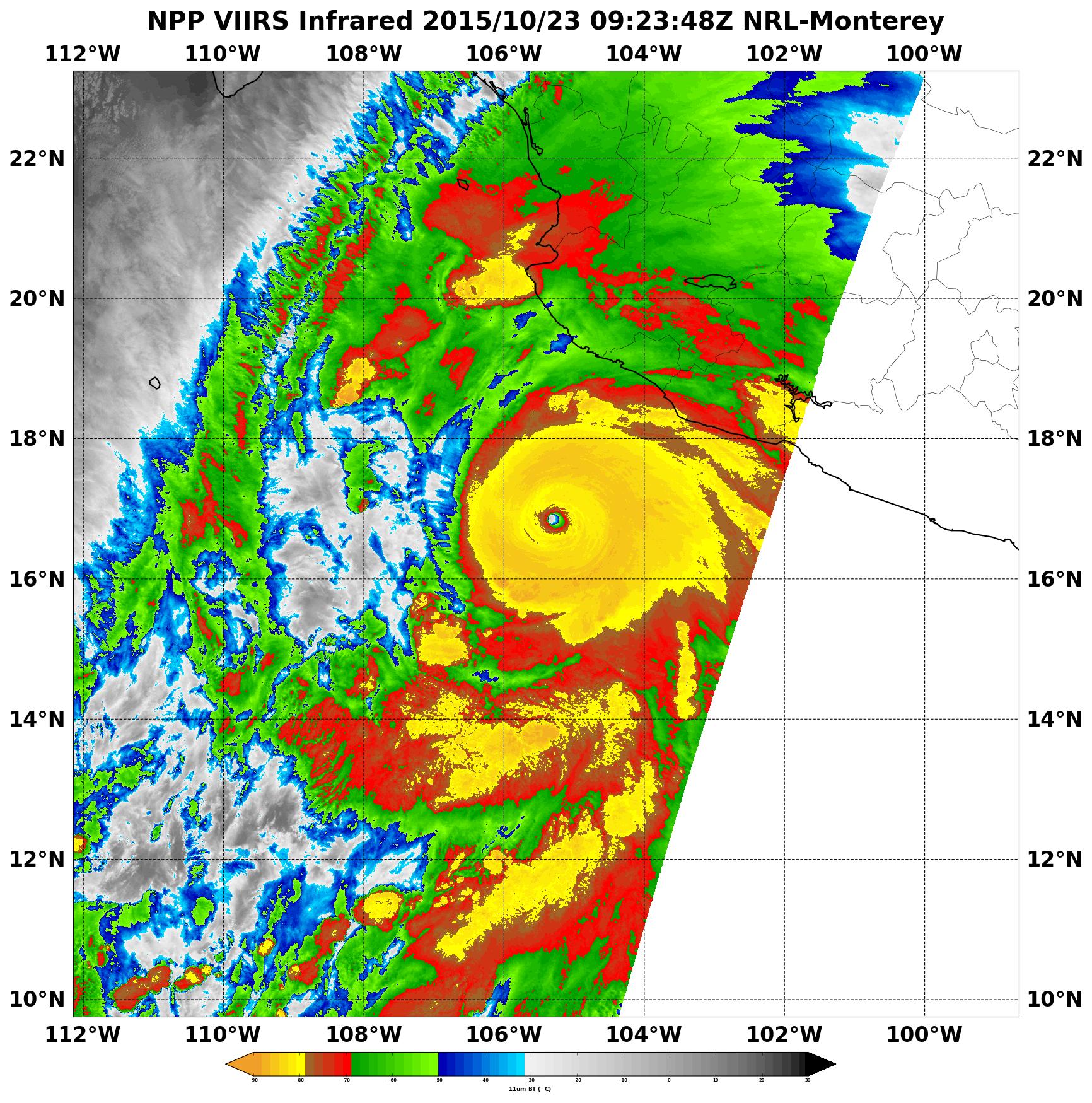
When NASA-NOAA’s Suomi NPP satellite passed over Patricia on October 23 at 0923 UTC (5:23 a.m. EDT) the Visible Infrared Imaging Radiometer Suite or VIIRS instrument that flies aboard Suomi NPP looked at the storm in infrared light. Cloud top temperatures of thunderstorms around the eyewall were near minus 90 Celsius (minus 130 Fahrenheit). Recent microwave imagery shows hints of a concentric eyewall developing. If the trend toward an eyewall replacement continues, it would cause the intensity to at least level off later today.
Two Records Broken
The National Hurricane Center reported that Patricia is the strongest hurricane on record in the National Hurricane Center’s area of responsibility (AOR) which includes the Atlantic and the eastern North Pacific basins. The minimum central pressure estimated from the aircraft data, 880 millibars, is the lowest ever for our AOR. The National Hurricane Center noted “It seems incredible that even more strengthening could occur before landfall later today. The official forecast shows only a little more strengthening before landfall.”
Latest Statistics and Location
At 8 a.m. EDT (1200 UTC) on Oct. 23, the eye of Hurricane Patricia was located near latitude 17.3 North, longitude 105.6 West. That’s about 145 miles (235 km) southwest of Manzanillo, Mexico and about 215 miles (345 km) south of Cabo Corrientes, Mexico.
Patricia was moving toward the north-northwest near 12 mph (19 kph) and a turn toward the north is expected later this morning, followed by a turn toward the north-northeast this afternoon. On the forecast track, the core of Patricia will make landfall in the hurricane warning area today, October 23, 2015 during the afternoon or evening.
Maximum sustained winds remain near 200 mph (325 kph) with higher gusts. The National Hurricane Center (NHC) said that Patricia is a category 5 hurricane on the Saffir-Simpson Hurricane Wind Scale. Some fluctuations in intensity are possible today, but Patricia is expected to remain an extremely dangerous category 5 hurricane through landfall. Hurricane force winds extend outward up to 30 miles (45 km) from the center and tropical storm force winds extend outward up to 175 miles (280 km). The estimated minimum central pressure is 880 millibars.
Winds, Rainfall, Storm Surge
NHC said that Hurricane conditions are expected to first reach the hurricane warning area this afternoon. Tropical storm conditions are beginning to spread across portions of the warning area. Patricia is expected to produce total rainfall accumulations of 8 to 12 inches, with isolated maximum amounts of 20 inches, over the Mexican states of Nayarit, Jalisco, Colima, Michoacan and Guerrero through Saturday. These rains could produce life-threatening flash floods and mud slides. An extremely dangerous storm surge is expected to produce significant coastal flooding near and to the right of where the center makes landfall. Near the coast, the surge will be accompanied by large and destructive waves.
Swells generated by Patricia are already affecting portions of the southern coast of Mexico, and will spread northwestward during the next day or so. These swells are likely to cause life-threatening surf and rip current conditions.
NHC forecasters said that Patricia is heading for potentially catastrophic landfall in southwestern Mexico later today. NHC Forecaster Pasch said “in addition to the coastal impacts, very heavy rainfall is likely to cause life-threatening flash floods and mud slides in the Mexican states of Jalisco, Colima, Michoacan and Guerrero continuing into Saturday.
Given the very mountainous terrain that Patricia should encounter after landfall, the cyclone should weaken even faster over land than predicted by the normal inland decay rate.”
Updated forecasts can be found at: www.nhc.noaa.gov
Rob Gutro
NASA’s Goddard Space Flight Center
Oct. 22, 2015 – NASA Sees Tropical Storm Patricia’s Lopsided Heavy Rains Along Mexican Coast
NASA’s GPM satellite saw that the western side of Tropical Storm Patricia was packing most of the storm’s moderate and heavy rainfall when it passed overhead in space. Patricia was close to the coast of western Mexico, and triggered warnings and watches. Patricia intensified into a hurricane on October 22.
Tropical Depression Twenty-E (TD20E) formed on October 20, 2015 off the Mexican coast southeast of Puerto Escondido, Mexico. Later that evening TD20E was upgraded to tropical Storm Patricia.
GPM Sees Lopsided Rainfall
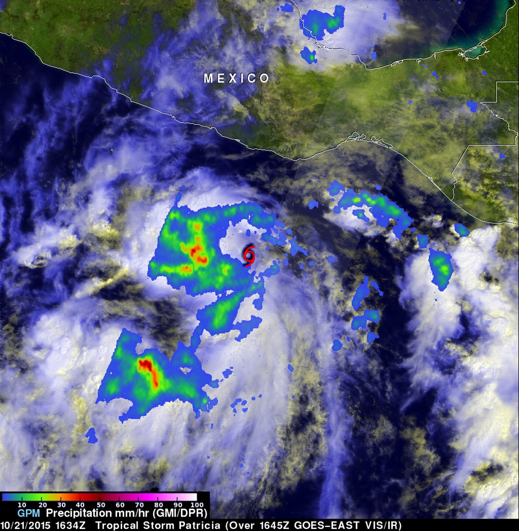
On October 21, 2015 at 1634 UTC (11:34 a.m. CDT) the GPM or Global Precipitation Measurement mission core observatory satellite flew over tropical storm Patricia. GPM is co-managed by NASA and the Japan Aerospace Exploration Agency and can measure rainfall rates from space.
GPM’s Microwave Imager (GMI) instrument had good coverage of the rainfall associated with the tropical storm. At NASA’s Goddard Space Flight Center in Greenbelt, Maryland, a complete picture of the storm came together that included rainfall and clouds. Rainfall data derived from GMI were overlaid on a visible/infrared image from NOAA’s GOES-West satellite that was captured at 1645 UTC (11:45 a.m. CDT). GPM’s Dual-Frequency Precipitation Radar (DPR) instrument scanned along an area east of Patricia’s center of circulation. Rain was measured by GMI falling at a rate of over 55 mm (2.16 inches) per hour in storms west of Patricia’s center.
Heavy Rains for Four Mexican States Expected on October 22
The heavy rains seen in the GPM imagery are expected to affect southwestern Mexico on October 22. The National Hurricane Center noted that Patricia is expected to produce total rainfall accumulations of 6 to 12 inches, with isolated maximum amounts of 20 inches, over the Mexican states of Jalisco, Colima, Michoacan and Guerrero later today, October 22, into Saturday, October 24.
Warnings and Watches on October 22
On October 22, 2015, Patricia had become a hurricane and at 8 a.m. EDT, the National Hurricane Center noted that the storm was intensifying quickly. Several warnings and watches were in effect. A Hurricane Warning is in effect from Cabo Corrientes to Punta San Telmo, and a Hurricane Watch is in effect from the east of Punta San Telmo to Lazaro Cardenas.
A Tropical Storm Warning is in effect from east of Punta San Telmo to Lazaro Cardenas, and a Tropical Storm Watch is in effect from east of Lazaro Cardenas to Tecpan De Galeana.
Patricia’s Stats on October 22, 2015
The National Hurricane Center (NHC) reported that at 8 a.m. EDT (1200 UTC) on October 22, the center of Hurricane Patricia was located near latitude 14.7 degrees north and longitude 103.0 degrees west. That put the center about 235 miles (375 km) south-southwest of Lazaro Cardenas, Mexico, and about 310 miles (500 km) south-southeast of Manzanillo, Mexico.
Patricia was moving toward the west-northwest near 17 mph (28 kph), and a turn toward the northwest is expected later today or tonight, followed by a turn toward the north on Friday. NHC said “On the forecast track, the center of the hurricane will be crossing the coast of Mexico in the hurricane warning area by Friday evening, October 23.”
Maximum sustained winds have increased to near 90 mph (150 kph) with higher gusts. Hurricane force winds extend outward up to 25 miles (35 km) from the center and tropical storm force winds extend outward up to 115 miles (185 km). The estimated minimum central pressure is 973 millibars. Continued strengthening is forecast, and Patricia is likely to become a major hurricane later today or tonight. Thereafter, additional strengthening is forecast until landfall.
NHC noted that a dangerous storm surge is expected to produce significant coastal flooding near and to the right of where the center makes landfall. Near the coast, the surge will be accompanied by large and destructive waves. Swells generated by Patricia are affecting portions of the coast of southern Mexico. These swells are likely to cause life-threatening surf and rip current conditions.
Hurricane conditions, heavy rainfall, dangerous storm surge, and ocean swells are all forecast by NHC. For updated forecasts, visit: www.nhc.noaa.gov.
Harold F. Pierce / Rob Gutro
NASA’s Goddard Space Flight Center
Oct. 21, 2015 – Satellite Sees Tropical Storm Patricia Form Near Western Mexico Coast
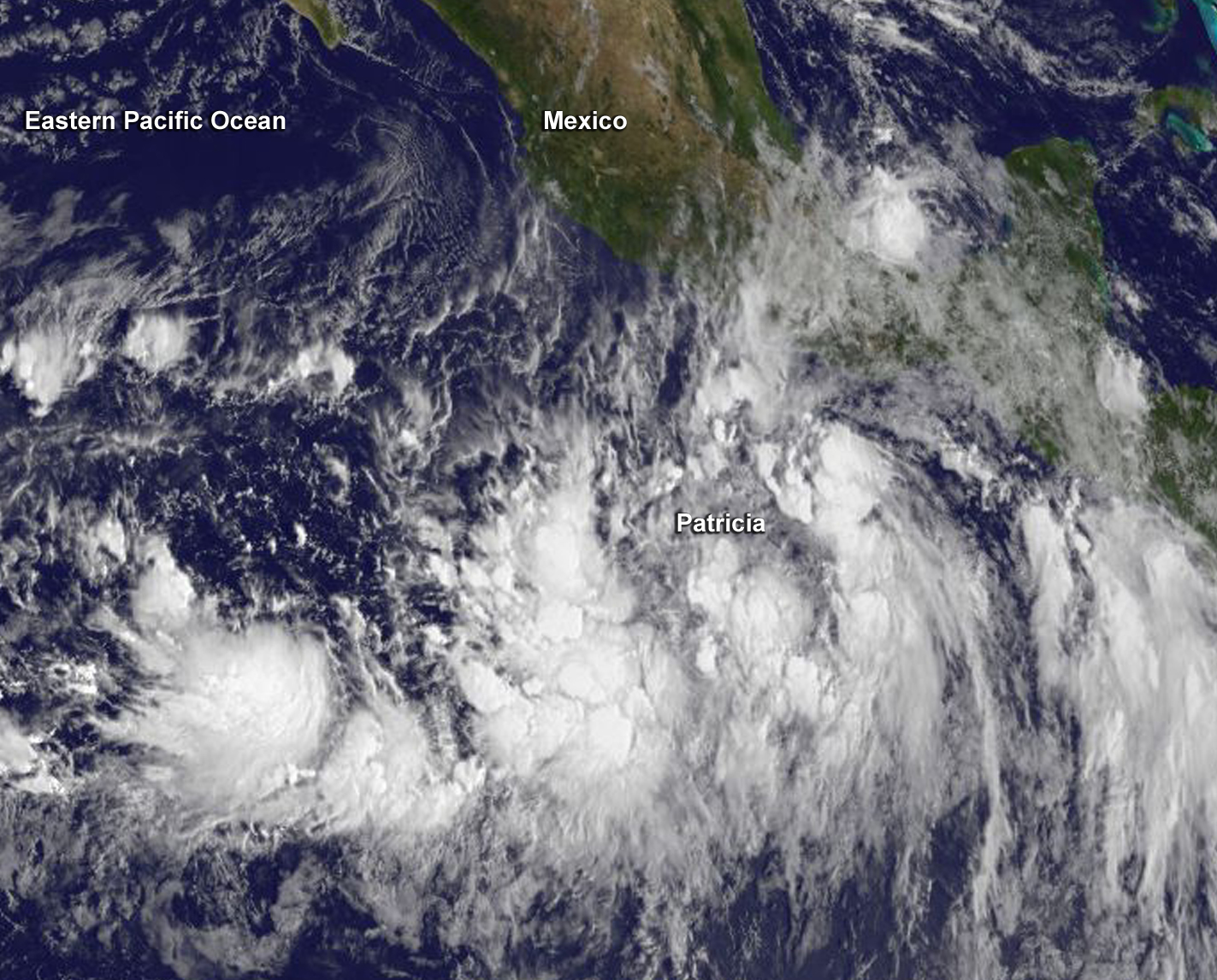
The low pressure area that was designated as System 97E on October 20 developed into the Eastern Pacific Ocean’s twentieth tropical depression of the season at 11 a.m. EDT. By 11 p.m. the depression became Tropical Storm Patricia and was seen strengthening by NOAA’s GOES-West satellite.
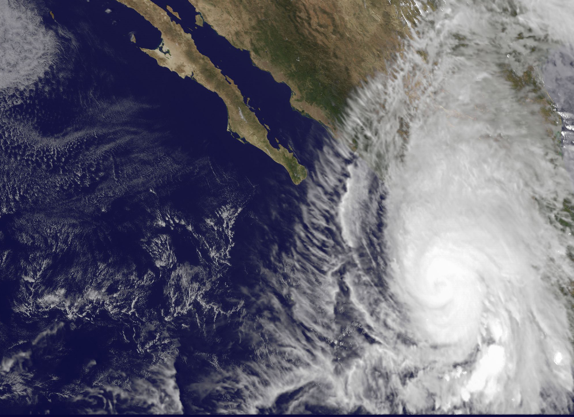
An image of the tropical storm was captured by NOAA’s GOES-West satellite that showed the storm near the coast. GOES-West is managed by NOAA, but the image was created by the NASA/NOAA GOES Project at the NASA Goddard Space Flight Center, Greenbelt, Maryland.
Visible and microwave satellite data showed that Patricia remains poorly organized at 11 a.m. EDT on October 21, 2015. The low-level circulation appeared elongated from north to south. According to the National Hurricane Center, convection (and the thunderstorm development and precipitation) is occurring mainly in an almost linear area west and south of the center.
A Hurricane Watch is in effect from Lazaro Cardenas to Playa Perula and a Tropical Storm Watch is in effect from east of Lazaro Cardenas to Tecpan De Galeana. Hurricane conditions are possible within the hurricane watch area by early Friday, October 23. Tropical storm conditions are possible within the watch areas by late Thursday or early Friday.
At 11 a.m. EDT (1500 UTC) on October 21, 2015 the center of Tropical Storm Patricia was located near latitude 12.9 degrees north and longitude 97.5 degrees west. That’s about 320 miles (515 km) south-southeast of Acapulco, Mexico. Patricia was moving toward the west near 12 mph (19 kph) and is expected to turn toward the west-northwest at night, then to the northwest on October 22. On the forecast track, the center of Patricia should approach the coast of southwestern Mexico on Friday, October 23.
Maximum sustained winds are near 40 mph (65 kph) with higher gusts and strengthening is forecast during the next 48 hours. The National Hurricane Center expects Patricia to become a hurricane Thursday or Thursday night.
The National Hurricane Center noted that Patricia is expected to produce total rainfall accumulations of 6 to 12 inches, with isolated maximum amounts of 20 inches, over the Mexican states of Jalisco, Colima, Michoacan and Guerrero later Thursday into Saturday, October 24. These rains could produce life-threatening flash floods and mud slides.
For updated forecasts on Patricia, visit the National Hurricane Center website:
www.nhc.noaa.gov
Rob Gutro
NASA’s Goddard Space Flight Center, Greenbelt, Md.