


Remnants of Ex-Tropical Storm Linda Spreading Inland
NOAA’s GOES-West satellite saw the remnants of former Tropical Storm Linda begin to spread inland over the northern Baja Peninsula of Mexico, and they are expected to affect the southwestern U.S. over the next couple of days.
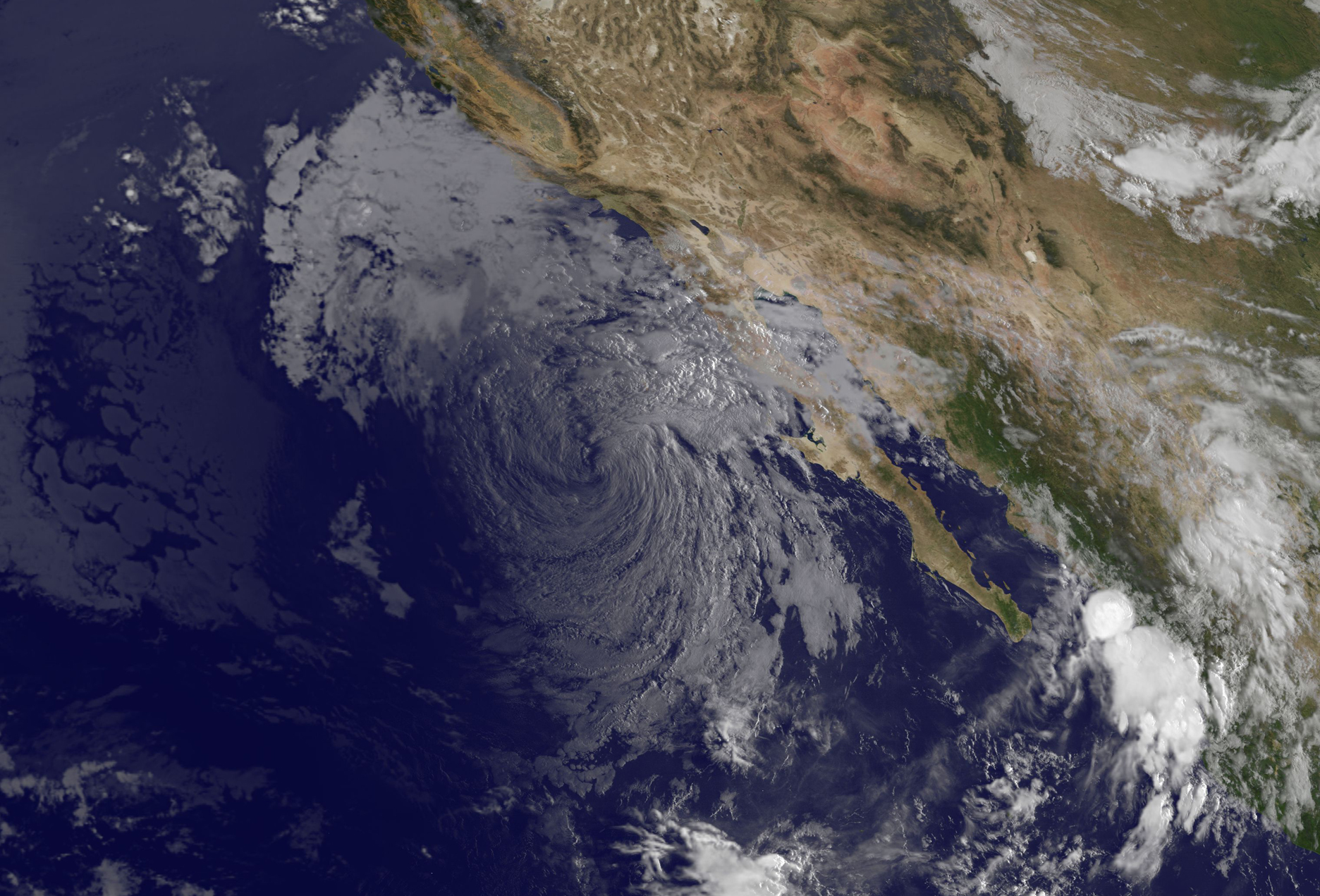
An image of the remnants of Tropical Storm Linda was taken from NOAA’s GOES-West satellite on Sept. 11 at 10:15 a.m. EDT and showed the eastern side its associated clouds over the northern Baja peninsula.
The last advisory issued on Linda from the National Hurricane Center came on September 10 at 2100 UTC (5 p.m. EDT). At that time, Post-tropical cyclone Linda was located near 26.0 North and 118.6 West, about 260 nautical miles west-southwest of Punta Eugenia, Mexico and moving northwest at 6 knots. Maximum sustained winds were near 40 knots at the time. The NHC noted that Linda had ceased to qualify as a tropical cyclone.
By September 11 at 1005 UTC (7:05 a.m. EDT), Linda’s remnants were centered near
26.5 North latitude and 119.5 West longitude. Winds of 20 to 30 knots were still occurring up to 150 nautical miles northeast of the center and out to 90 nautical miles southwest of the center.
The National Hurricane Center noted that moisture associated with the remnant low of Linda is spreading northward into northern Baja California and portions of the southwestern U.S., which could trigger some shower and thunderstorm activity.
In addition to the showers the Linda can bring inland, ocean swells are still affecting the Baja California peninsula, and continue to propagate toward the U.S. southern California coastline. These swells will result in an increased risk of rip currents and dangerous high surf through at least through September 11.
NHC noted that the low will continue to gradually spin down during the next few days with winds diminishing to 20 knots or less and seas subsiding to less than 8 feet by Saturday morning, September 12.
Rob Gutro
NASA’s Goddard Space Flight Center
Sep. 10, 2015 – Satellite Sees Tropical Storm Linda Weakening Near Baja California
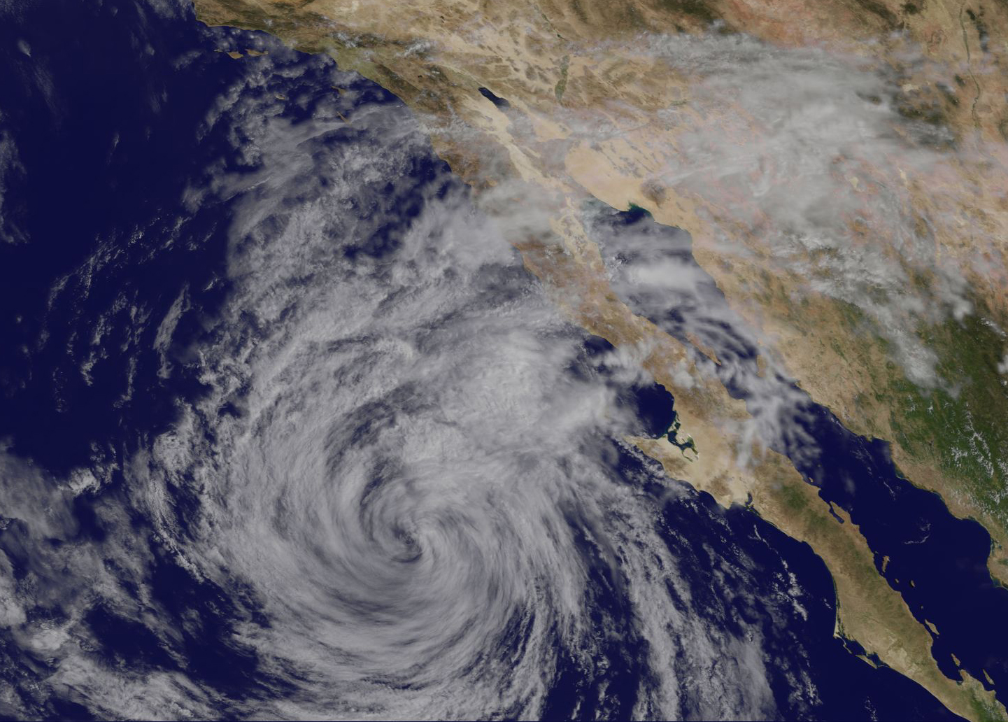
NOAA’s GOES-West satellite saw a much weaker Tropical Storm Linda near the Baja California Peninsula of Mexico on September 10. The infrared image showed Linda as a swirl of clouds with strongest thunderstorms on the eastern side.
Although Linda was downgraded to a tropical storm it was close enough to the Baja California coast to cause concern with ocean conditions. The Pacific coasts of Baja California will be affected by swells, which will generate life-threatening surf and riptide conditions.
At 11 a.m. EDT (1500 UTC), the center of Tropical Storm Linda was located near latitude 26.0 North, longitude 118.6 West. That’s about 250 miles (400 km) west-southwest of Punta Eugenia, Mexico.
Linda was moving toward the northwest near 7 mph (11 kph) and the National Hurricane Center forecast expects that this motion is expected to continue today. A turn toward the west-northwest and a decrease in forward speed are expected tonight. Maximum sustained winds have decreased to near 40 mph (65 kph) with higher gusts.
Additional weakening is forecast, and Linda is expected to become a remnant low later on September 10 as it continues to turn to the west-northwest and away from land.
Rob Gutro
NASA’s Goddard Space Flight Center
Sep. 09, 2015 – NASA Saw Linda’s Hurricane-Force Winds Up to 30 Miles from Center

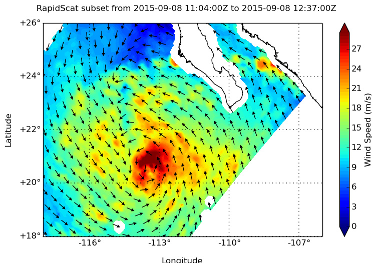
Hurricane Linda is rapidly weakening after reaching major hurricane status in the Eastern Pacific Ocean. When NASA’s RapidScat observed Linda, data showed those hurricane-force winds extended about 30 miles from the center.
RapidScat data on September 8 at 7 a.m. EDT showed that the strongest sustained winds concentrated around the center of Linda’s tight circulation and were stronger than 30 meters per second (108 kph/67 mph). At that time, hurricane force winds extended outward up to 30 miles (45 km) from the center and tropical storm force winds extend outward up to 105 miles (165 km). The image was created by the RapidScat team at NASA’s Jet Propulsion Laboratory, Pasadena, California.
On September 8 at 5:10 p.m. EDT (21:10 UTC) the MODIS instrument aboard NASA’s Aqua satellite captured a visible image of Hurricane Linda that showed its center west of Baja California, Mexico. The image also showed Linda maintained an eye and that the clouds in the hurricane’s eastern quadrant were over the southern Baja.
On September 9 at 5 a.m. EDT (2 a.m. PDT/0900 UTC), the center of Hurricane Linda was located near latitude 23.2 North, longitude 116.3 West. That puts the center of Linda about 405 miles (655 km) west of the southern tip of Baja California, Mexico.
Linda was moving toward the northwest near 12 mph (19 kph). The National Hurricane Center forecast calls for a northwestward motion with some decrease in forward speed is expected through Thursday, September 10.
Maximum sustained winds have decreased to near 100 mph (155 kph) with higher gusts. Rapid weakening is expected during the next 48 hours, and Linda is forecast to weaken to a tropical storm by early Thursday, and become a remnant low by Friday morning. The estimated minimum central pressure is 969 millibars.
Infrared satellite imagery showed that Linda’s cloud top temperatures have warmed indicating less uplift in the storm to create powerful thunderstorms. The National Hurricane Center noted that the cloud pattern has continued to deteriorate overnight and Linda’s eye had become much less distinct.
There are no coastal watches or warnings in effect. However, Hurricane Linda is generating rough surf along the southern coasts of Baja California. Those are expected to spread northward into southern California by Thursday, September 10.
Rain from the edge of Linda could affect southern Baja California as the storm continues moving north toward the southwestern U.S. over the next several days.