


El Niño years can have a big impact on the littlest plants in the ocean, and NASA scientists are studying the relationship between the two.
In El Niño years, huge masses of warm water – equivalent to about half of the volume of the Mediterranean Sea – slosh east across the Pacific Ocean towards South America. While this warm water changes storm systems in the atmosphere, it also has an impact below the ocean’s surface. These impacts, which researchers can visualize with satellite data, can ripple up the food chain to fisheries and the livelihoods of fishermen.
El Niño’s mass of warm water puts a lid on the normal currents of cold, deep water that typically rise to the surface along the equator and off the coast of Chile and Peru, said Stephanie Uz, ocean scientist at Goddard Space Flight Center in Greenbelt, Maryland. In a process called upwelling, those cold waters normally bring up the nutrients that feed the tiny organisms, which form the base of the food chain.
“An El Niño basically stops the normal upwelling,” Uz said. “There’s a lot of starvation that happens to the marine food web.” These tiny plants, called phytoplankton, are fish food – without them, fish populations drop, and the fishing industries that many coastal regions depend on can collapse.
This video is public domain and can be downloaded at the Scientific Visualization Studio
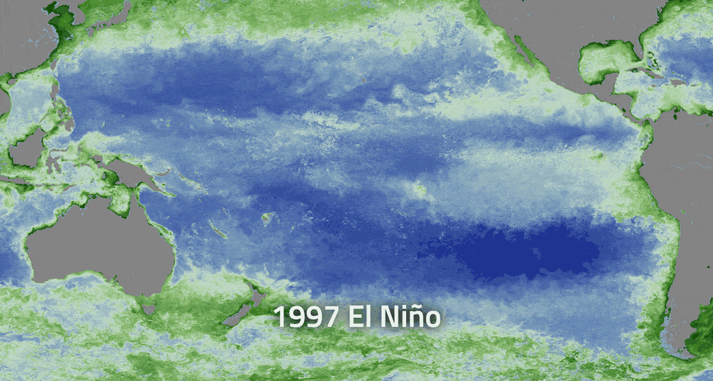
With NASA satellite data, and ocean color software called SeaDAS, developed at the Ocean Biology Processing Group at Goddard, Uz has been mapping where these important phytoplankton appear. Orbiting instruments like the Moderate Resolution Imaging Spectrometer on the Aqua satellite, and the Visible Infrared Imaging Radiometer Suite on the Suomi NPP satellite collect data on the color of the ocean. From shades of blue and green, scientists can calculate the amount of green chlorophyll – and therefore the amount of phytoplankton present.
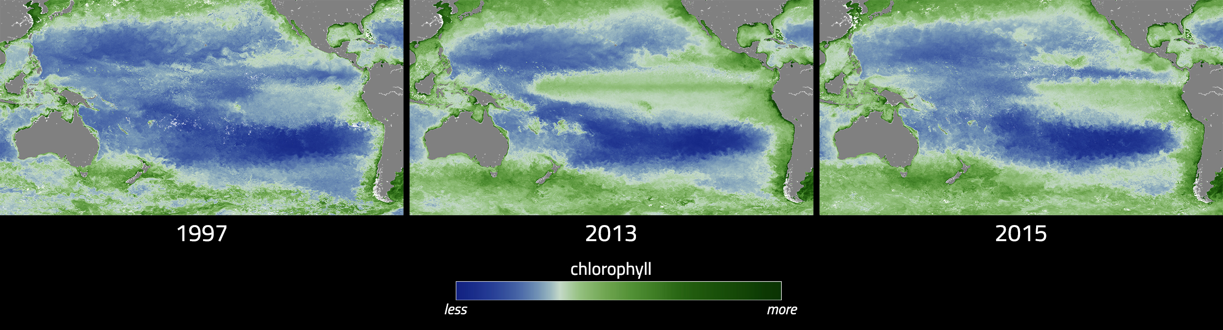
The ocean color maps, based on a month’s worth of satellite data, can show that El Niño impact on phytoplankton. In December 2015, at the peak of the current El Niño event, there was more blue – and less green chlorophyll – in the Pacific Ocean off of Peru and Chile, compared to the previous year. Uz and her colleagues are also watching as the El Niño weakens this spring, to see when and where the phytoplankton reappear as the upwelling cold water brings nutrients back to the region.
“They can pop back up pretty quickly, once they have a source of nutrients,” Uz said.
Researchers can also examine the differences in ocean color between two different El Niño events. During the large 1997-1998 El Niño event, the green chlorophyll virtually disappeared from the coast of Chile. This year’s event, while it caused a drop in chlorophyll primarily along the equator, was much less severe for the coastal phytoplankton population. The reason – the warmer-than-normal waters associated with the two El Niño events were centered in different geographical locations. In 1997-1998, the biggest ocean temperature abnormalities were in the eastern Pacific Ocean; this year the focus was in the central ocean. This difference impacts where the phytoplankton can feed on nutrients, and where the fish can feed on phytoplankton.
“When you have an East Pacific El Niño, like 1997-1998, it has a much bigger impact on the fisheries off of South America,” Uz said. But Central Pacific El Niño events, like this year’s, still have an impact on ocean ecosystems, just with a shift in location. Researchers are noting reduced food available along the food chain around the Galapagos Islands, for example. And there has been a drop in phytoplankton off the coast of South America, just not as dramatically as before.
Scientists have more tools on hand to study this El Niño, and can study more elements of the event, Uz said. They’re putting these tools to use to ask questions not just about ocean ecology, but about the carbon cycle as well.
“We know how important phytoplankton are for the marine food web, and we’re trying to understand their role as a carbon pump,” Uz said. The carbon pump refers to one of the ways the Earth system removes carbon dioxide from the atmosphere. When phytoplankton die, their carbon-based bodies sink to the ocean floor, where they can remain for millions of years. El Niño is a naturally occurring disruption to the typical ocean currents, she said – so it’s important to understand the phenomenon to better attribute what occurs naturally, and what occurs due to human-caused disruptions to the system.
Other scientists at Goddard are investigating ways to forecast the ebbs and flows of nutrients using the center’s supercomputers, incorporating data like winds, sea surface temperatures, air pressures and more.
“It’s like weather forecasts, but for bionutrients and phytoplankton in the ocean,” said Cecile Rousseaux, an ocean modeler with Goddard’s Global Modeling and Assimilation Office. The forecasts could help fisheries managers estimate how good the catch could be in a particular year, she said, since fish populations depend on phytoplankton populations. The 1997-1998 El Niño led to a major collapse in the anchovy fishery off of Chile, which caused economic hardships for fishermen along the coast.
So far, Rousseaux said, the phytoplankton forecast models haven’t shown any collapses for the 2015-2016 El Niño, possibly because the warm water isn’t reaching as far east in the Pacific this time around. The forecast of phytoplankton populations effort is a relatively new effort, she said, so it’s too soon to make definite forecasts. But the data so far, from the modeling group and others, show conditions returning to a more normal state this spring.
The next step for the model, she said, is to try to determine which individual species of phytoplankton will bloom where, based on nutrient amounts, temperatures and other factors – using satellites and other tools to determine which kind of microscopic plant is where.
“We rely on satellite data, but this will go one step further and give us even more information,” Rousseaux said.
For more information, visit: