


NASA Sees Wind Shear End Tropical Cyclone Amos
On Sunday, April 24, Tropical Cyclone Amos ran into increasing wind shear that tore the storm apart. A composite satellite image from two satellites showed waning precipitation and lack of thunderstorm development from wind shear.
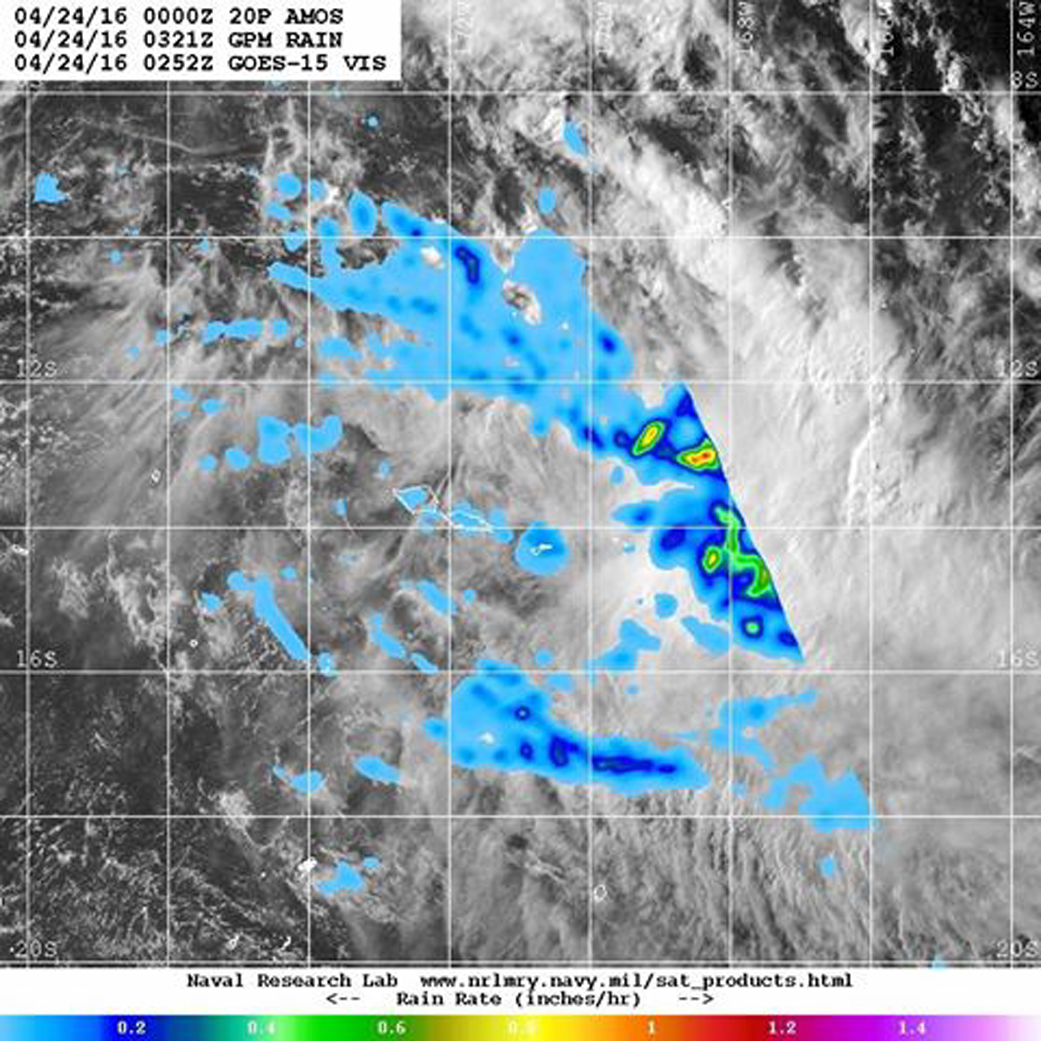
Visible imagery from NOAA’s GOES-West on April 24 at 0252 UTC (April 23 at 10:52 p.m. EDT) and precipitation data from NASA and the Japan Aerospace Exploration Agency’s Global Precipitation Measurement (GPM) Mission on April 24 at 0321 UTC (April. 23 at 11:21 a.m. EDT) was combined at the U.S. Naval Research Laboratory in Washington, D.C. The imagery showed the storm had elongated because of the wind shear. Heaviest rainfall, at about 1 inch (25 mm) per hour appeared in the northwestern quadrant of the storm on GPM radar.
By 1500 UTC (11 a.m. EDT) on April 24, Amos moved past Pago Pago and continued on an easterly track at 7 knots (8 mph/12.9 kph) while weakening. At that time, Amos’ maximum sustained winds were near 40 knots (46 mph/74 kph) and it was weakening quickly.
By the end of the day, Amos had dissipated in the Southern Pacific Ocean.
Rob Gutro
NASA’s Goddard Space Flight Center
Apr. 22, 2016 – NASA Sees Tropical Cyclone Amos Threatening American Samoa
As the seven islands of American Samoa were bracing for Tropical Cyclone Amos, NASA’s Aqua satellite saw the storm affecting the Southwestern Pacific Islands of Wallis and Futuna. Warnings were already in effect for American Samoa on April 22 as the storm continued moving east toward the islands.
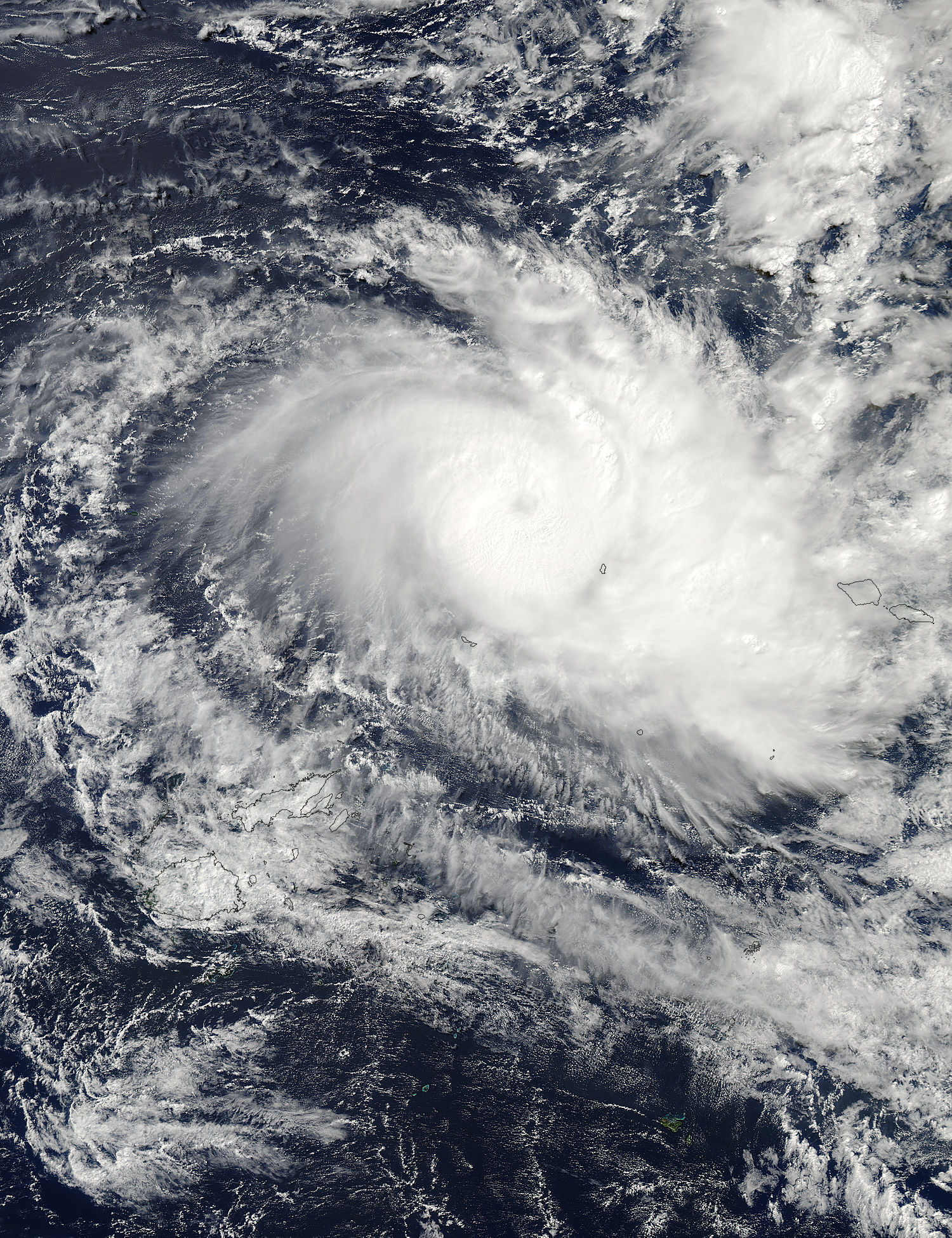
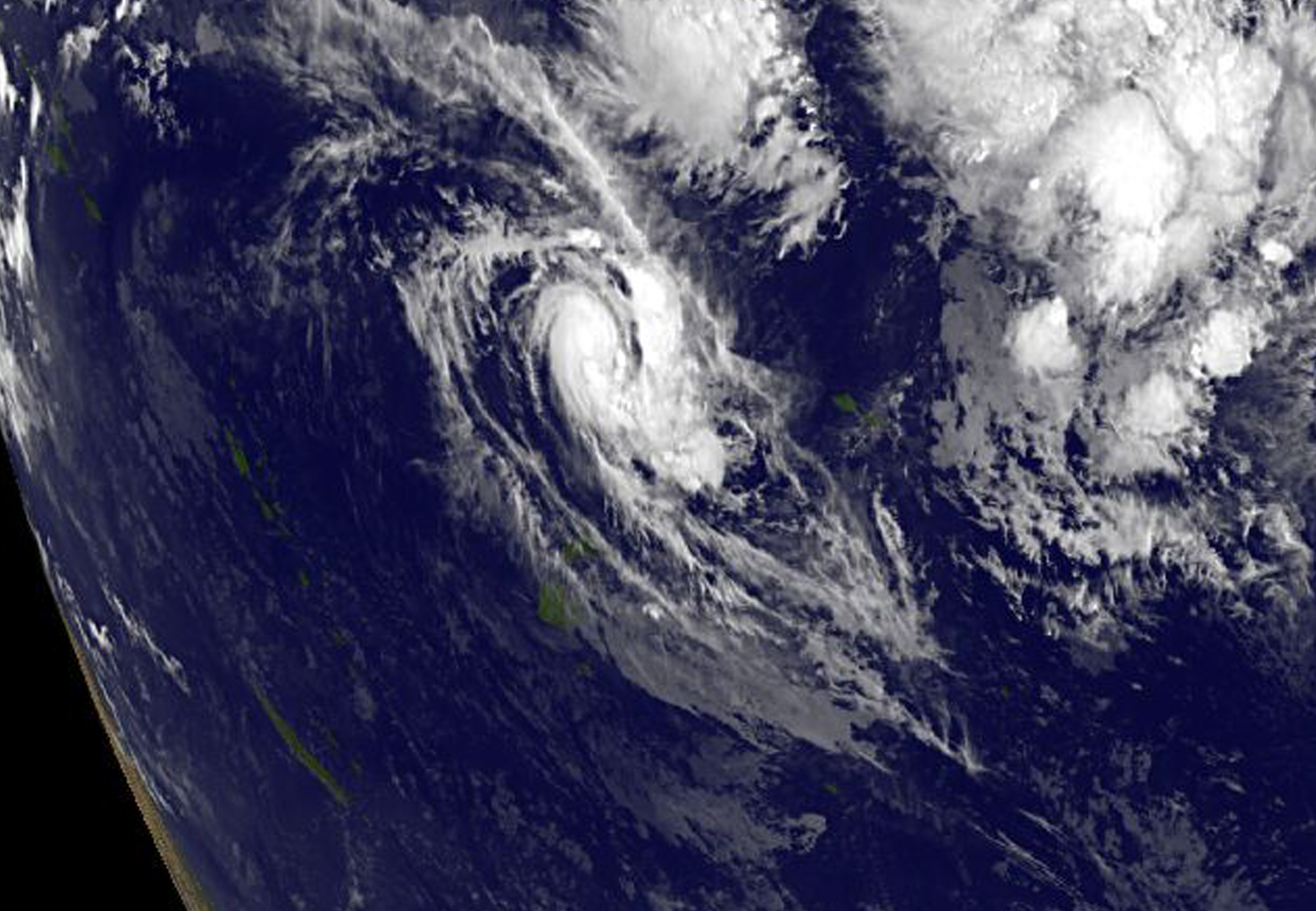
A visible image of Amos was taken on April 22 at 0145 UTC (April 21 at 9:45 p.m. EDT) from the Moderate Resolution Imaging Spectroradiometer instrument aboard NASA’s Aqua satellite. In the image, the southeastern fringe of strong thunderstorms circling the storm’s center was near the island of Mata Utu, the capital of Wallis and Futuna, France. A large band of thunderstorms feeding into the center from the east is seen just west of American Samoa. American Samoa is a U.S. territory covering seven islands and atolls. The largest island, Tutuila, is the home of Pago Pago, the capital city.
On Friday, April 22 at 1500 UTC (11 a.m. EDT) Tropical Cyclone Amos’ maximum sustained winds increased to 90 knots (103.6 mph/ 166.7 kph). The storm was moving to the east at 8 knots (9.2 mph/14.8 kph).
The 2:25 a.m. local time on Friday, April 22, the National Weather Service (NWS) in Pago Pago issued a high surf warning for all shores of American Samoa. NWS said that Hurricane Amos will generate dangerous surfs of 14 to 16 feet Friday afternoon along the southwest, west, northwest and north facing reefs, then building to near 18 to 22 feet Friday night into Saturday.
A high surf warning indicates dangerous large breaking waves will pound the shoreline in the warning area producing deadly rip currents and localized beach erosion. Also it is extremely dangerous to fish or observe waves from rocks during high surf conditions. Unwary beach walkers can be caught off guard as waves suddenly race farther up the beach than normal.
For updated forecasts from the NWS, Pago Pago, visit: http://www.weather.gov/ppg.
Forecasters at the Joint Typhoon Warning Center expect the storm to move east and intensify further to 115 knots (132.3 mph/213 kph), before a weakening trend begins as the storm turns to the south.
Rob Gutro
NASA’s Goddard Space Flight Center
Apr. 21, 2016 – NASA Sees Tropical Cyclone Amos Intensifying
Tropical Cyclone 20P, now named Amos, has continued to organize and strengthen in the Southern Pacific and is now threatening Pago Pago. NOAA’s GOES-West satellite captured an image of the storm on April 21 as a Flash Flood Watch continued for all islands in American Samoa.
From its geostationary position over the Eastern Pacific Ocean, NOAA’s GOES-West satellite captured an image of Tropical Cyclone Amos near Fiji on April 21 at 1200 UTC (8 a.m. EDT) that showed the storm had developed a more organized circulation. The image was created by the NASA/NOAA GOES Project at NASA’s Goddard Space Flight Center in Greenbelt, Maryland.
Animated multispectral satellite imagery showed that the low-level circulation center was slowly consolidating and there were strong thunderstorms obscuring a ragged but defined center. Microwave data showed that a well-defined eye feature had developed underneath the cloud cover. JTWC forecasters noted “This excellent low-level structure, in combination with the radial outflow, suggests an Imminent rapid intensification phase.”
At 0900 UTC (5 a.m. EDT) Tropical Cyclone Amos’ maximum sustained winds had increased to 45 knots (51.7 mph/83.3 kph). The Joint Typhoon Warning Center noted that the storm appears to be intensifying rapidly and is expected to become a hurricane by April 22.
Amos was centered near 13.0 degrees south latitude and 179.3 degrees west longitude, about 507 nautical miles (583.4 miles/939 km) west of Pago Pago, Samoa. Amos was moving to the southeast at 4 knots (4.6 mph/7.4 kph).
The National Weather Service in Pago Pago has issued a Flash Flood Watch for all islands of American Samoa through Saturday, April 23. The NWS noted “increasing rainfall activities and thunderstorms are expected through the weekend. An active surface trough will linger over the Samoan Islands…and this trough will trigger numerous showers through Friday morning (Apr. 22) before the arrival of another series of rainfall activities associated with tropical cyclone Amos during Friday afternoon into Saturday night. The potential threat for flash flooding is possible.” For updated warnings and forecasts, visit NWS, Pago Pago: http://www.weather.gov/ppg.
Amos is forecast to accelerate eastward to southeastward as it tracks along the edge of a near-equatorial steering ridge (elongated area) of high pressure.
Rob Gutro
NASA’s Goddard Space Flight Center
April 20, 2016 – NASA Sees Birth of Tropical Cyclone 20P, Threatens American Samoa
As Tropical Cyclone 20P formed in the Southern Pacific Ocean NASA’s Aqua satellite analyzed storm cloud top temperatures while the RapidScat instrument looked at surface winds. The National Weather Service in Pago Pago expects the tropical storm to affect American Samoa by the weekend.
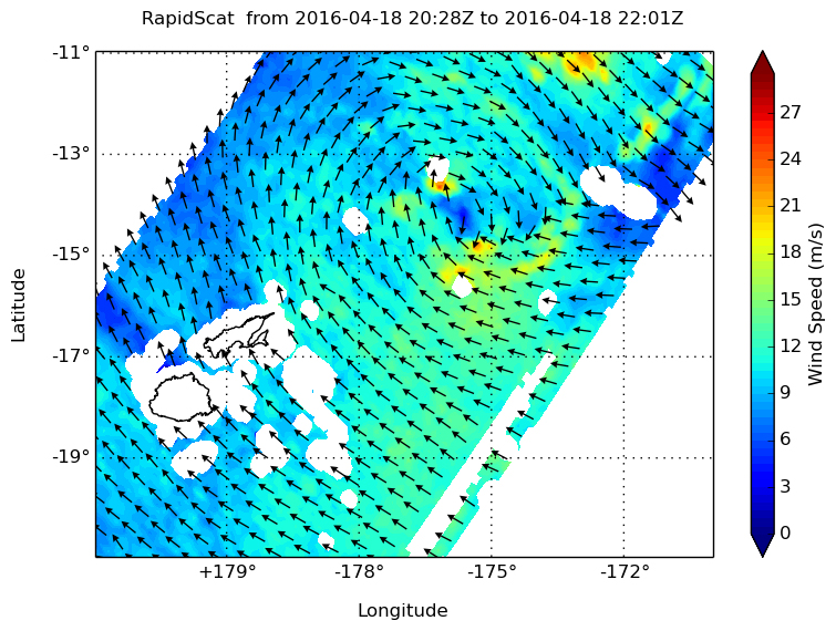
Before it became a tropical storm today, April 20, NASA’s RapidScat instrument spied tropical-storm-force winds on the southern side of the developing tropical low pressure area on April 18. RapidScat saw strongest sustained surface winds south of the center of circulation near 21 meters per second (46.9 mph/75.6 kph).
RapidScat is a scatterometer instrument that flies aboard the International Space Station. It measures surface wind speeds and direction over open waters of oceans. Images from RapidScat data are made into images at NASA’s Jet Propulsion Laboratory in Pasadena, California where the mission is managed.
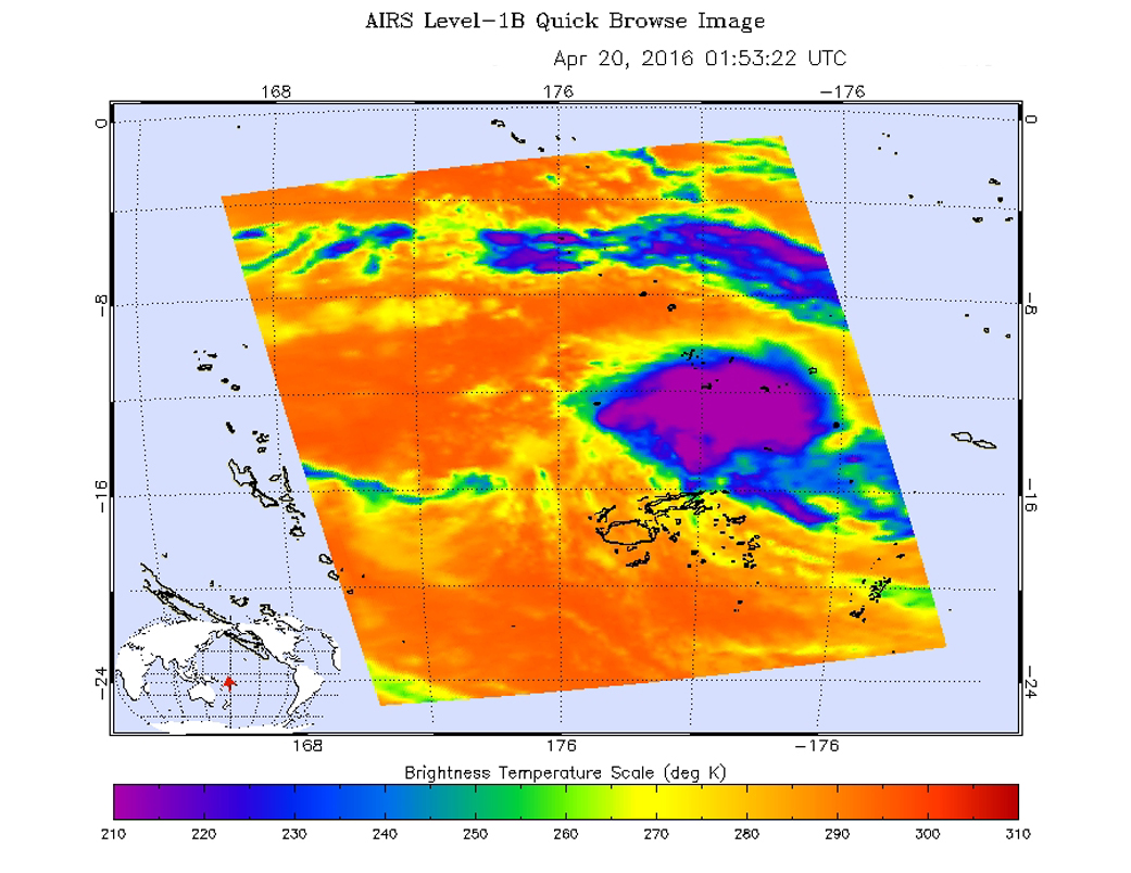
On April 20 at 01:53 UTC (April 19 at 9:53 p.m. EDT) infrared temperature data from the Atmospheric Infrared Sounder instrument that flies aboard NASA’s Aqua satellite looked at the tropical low pressure area. The developing Tropical depression, located northeast of Fiji showed cold cloud top temperatures near minus 63 degrees Fahrenheit (minus 52 Celsius) indicating some strong storms.
At 0900 UTC (5 a.m. EDT), Tropical cyclone 20P had maximum sustained winds near 35 knots (40 mph/62 kph) making it a tropical storm. It was centered near 12.9 degrees south latitude and 178.8 degrees west longitude, about 352 nautical miles (405.3 miles/ 652.3 km) west of Avata, Samoa. 20P was moving to the west-northwest at 6 knots (6.9 mph/11.1 kph).
The National Weather Service in Pago Pago issued a high surf advisory on April 20 that includes warnings for rip currents. NWS noted “An active surface trough will continue to linger over the Samoan islands through the week. An intensifying tropical cyclone will turn and move over the Samoan islands by at least Saturday. Hazardous seas will continue to build through the weekend…reaching extremely dangerous heights by Friday night.
A flash flood watch is in effect for all islands of American Samoa through Saturday, April 23. NWS noted that “an active trough will remain nearly stationary over the Samoan islands through the week. This trough will continue to increase the potential for flash flooding across the territory…especially since grounds have been saturated.”
The Joint Typhoon Warning Center forecast calls for 20P to curve to the east and intensify to 60 knots (69 mph/111 kph) before weakening south of Pago Pago.