


Carlos (was 03E – Eastern Pacific)
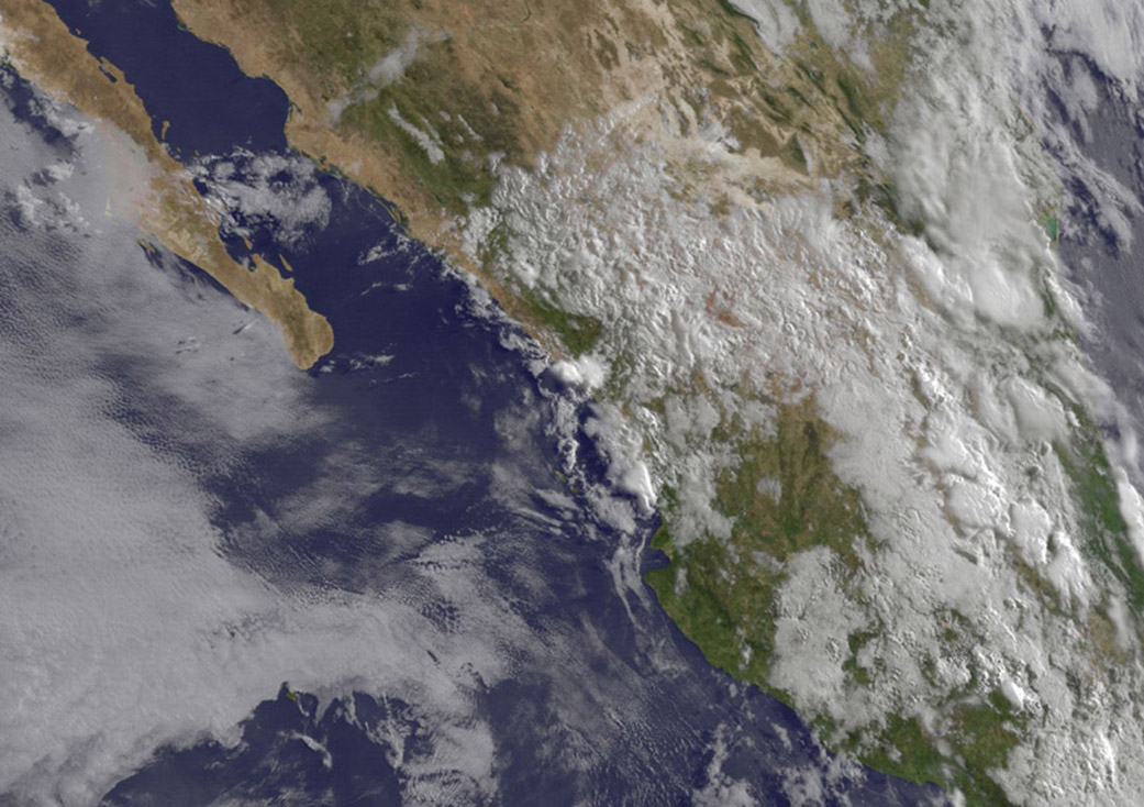
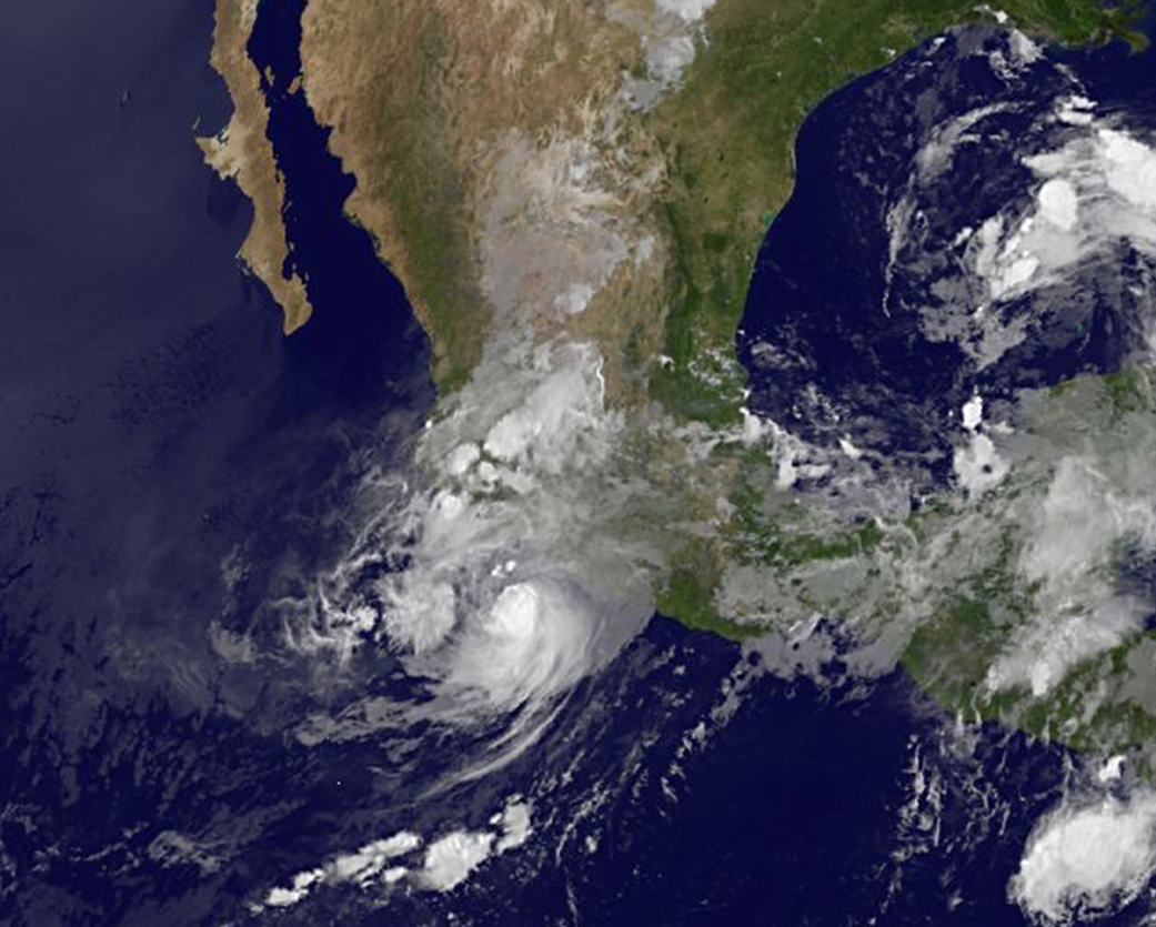
Former Hurricane Carlos is now just a memory as the former tropical cyclone dissipated over western Mexico early on June 18.
NOAA’s GOES-West satellite captured an image of some of Carlos’ remnant clouds at 13:45 UTC (9:45 a.m. EDT). The National Hurricane Center noted that there were no other areas in the Eastern Pacific Ocean suspect for development over the next couple of days.
Rob Gutro
NASA’s Goddard Space Flight Center
June 17, 2015 – NASA Shows a Weaker Compact Tropical Storm Carlos
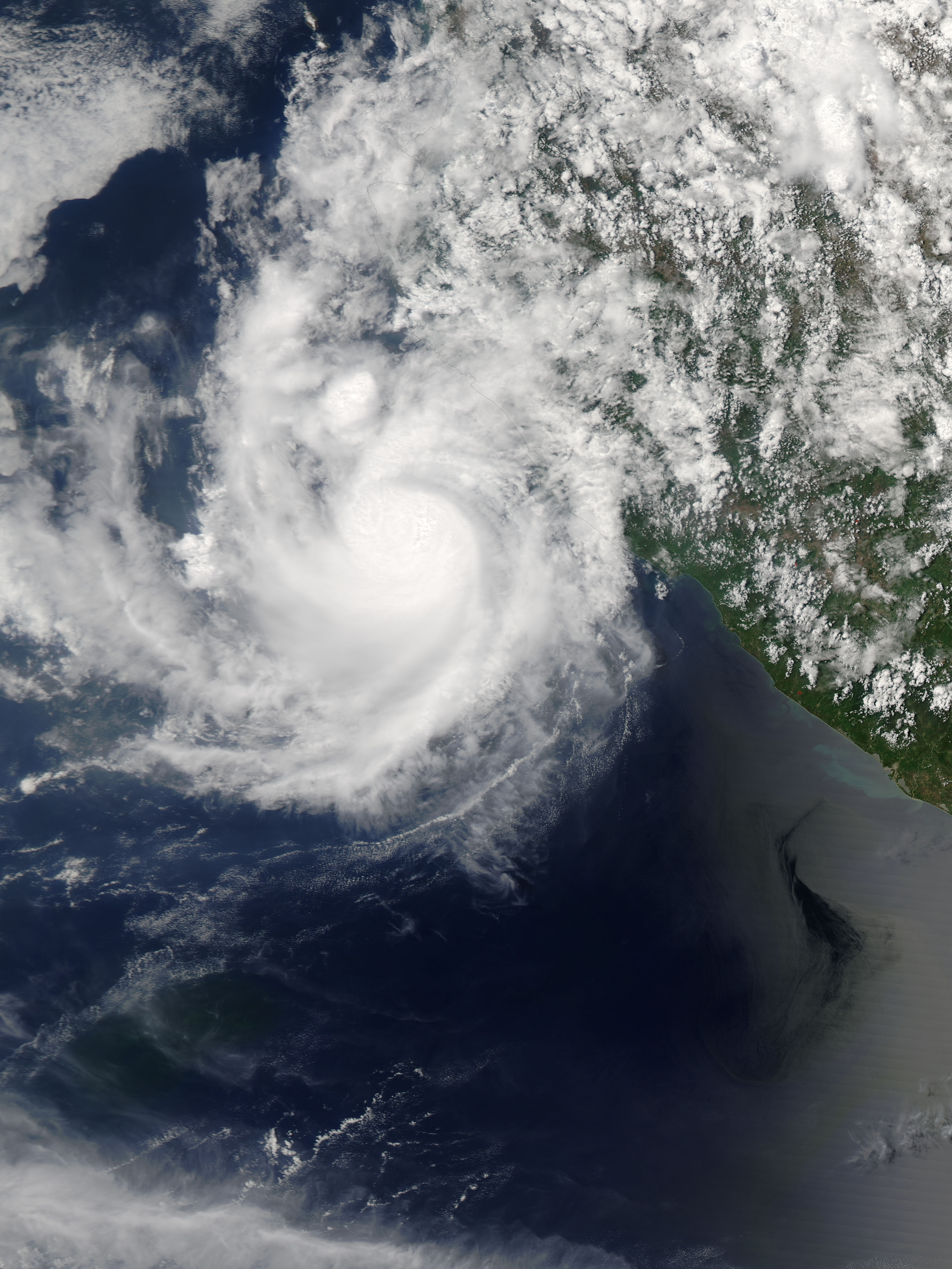
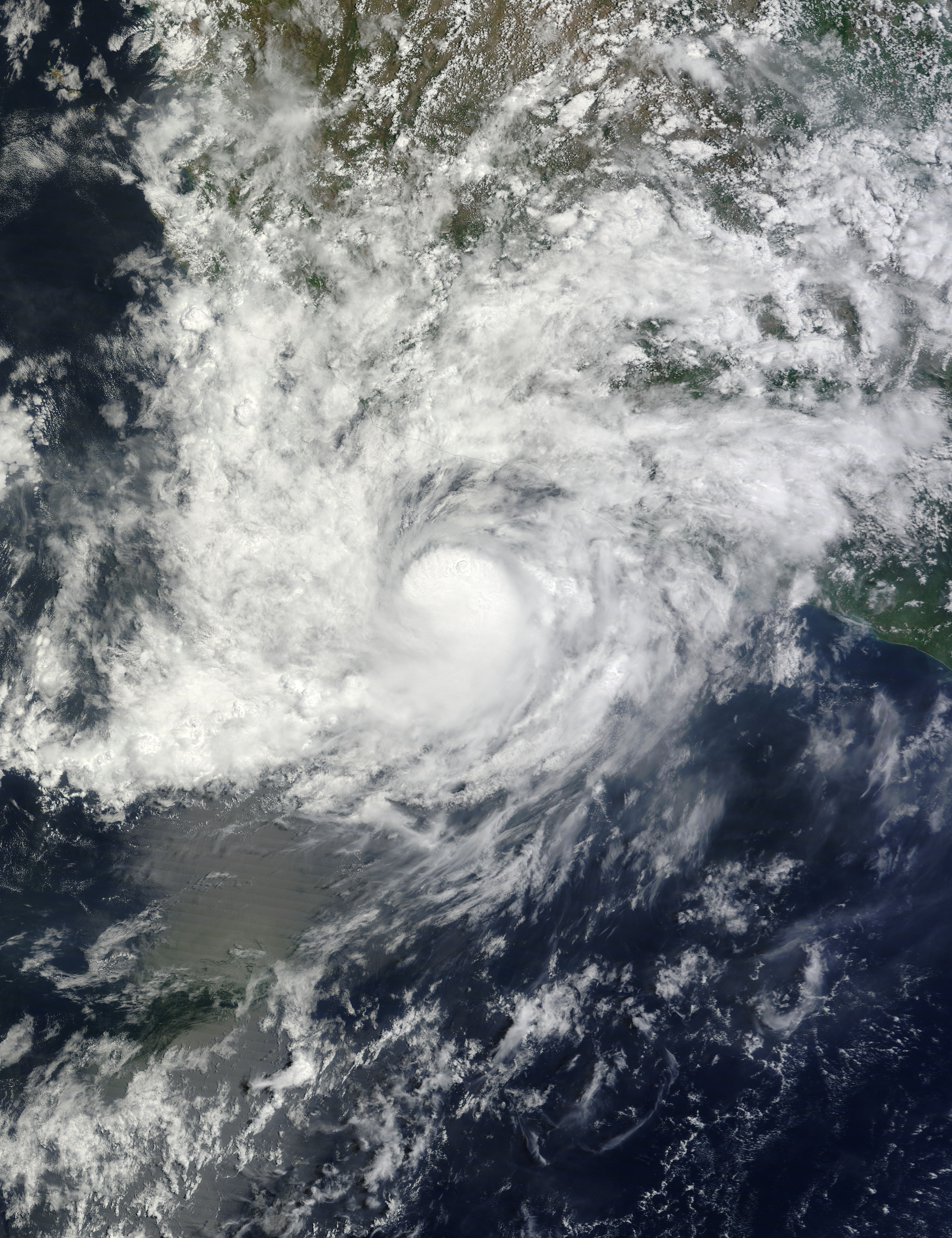
Hurricane Carlos weakened to a tropical storm on June 17 and remains a small storm that appears tightly wound on satellite imagery. Carlos is expected to spin down quickly.
On June 17, a Tropical Storm Warning was in effect from Punta San Telmo to Cabo Corrientes, Mexico as Carlos continued to move along the coast of western Mexico.
The MODIS instrument aboard NASA’s Aqua satellite captured a visible image of Hurricane Carlos off the west coast of Mexico on June 16 at 19:55 UTC (3:55 p.m. EDT). On June 17 at 13:30 UTC (9:30 a.m. EDT), NOAA’s GOES-West satellite also showed Carlos’ very compact area of clouds and showers hugging the coastline. Both images showed a very compact storm with thunderstorms wrapped tightly around the center of circulation. Tropical-storm-force winds extend outward up to 35 miles (55 km) from the center.
At 8 a.m. EDT (1200 UTC), the center of Tropical Storm Carlos was located near latitude 19.4 North, longitude 105.1 West. That puts the center about 10 miles (20 km) south of Playa Perula, Mexico and about 75 miles (125 km) south-southeast of Cabo Corrientes, Mexico.
Carlos was moving toward the north-northwest near 9 mph (15 kph) and that general motion is expected to continue until dissipation occurs on Friday. The estimated minimum central pressure is 1000 millibars.
Maximum sustained winds have rapidly decreased to near 45 mph (75 kph) with higher gusts. Additional rapid weakening is expected as Carlos moves near or over the coast of western Mexico today.
Carlos is expected to produce additional rainfall accumulations of 1 to 3 inches across the Mexican states of Michoacan, Colima, Jalisco, Nayarit through June 18. These rains may produce life-threatening flash floods and mud slides, especially in areas of higher terrain. In addition, the southwestern Mexico coastline is expected to continue experiencing ocean swells for the next day or two.
The National Hurricane Center (NHC) discussion on June 16 cited moderate northerly vertical wind shear and mid to upper-level dry, stable, air penetrating the cloud pattern from western Mexico as factors that have been weakening Carlos. NHC forecaster Roberts noted “Small, compact, tropical cyclones such as Carlos are notorious for spinning down as quickly as they can rapidly intensify.”
For updated forecasts on Carlos, visit the NHC website at: www.nhc.noaa.gov
NHC expects Carlos to become a tropical depression by night-time on June 16, and weaken further to a remnant low pressure system by June 17 as it moves off of the coast of Mexico and into the southern Gulf of California.
Rob Gutro
NASA’s Goddard Space Flight Center
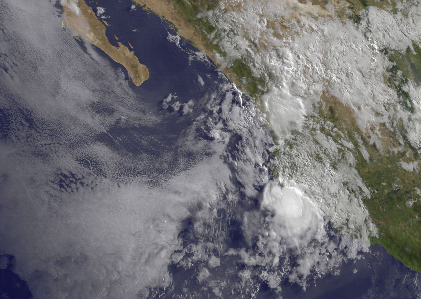
June 16, 2015 – NASA Sees Hurricane Carlos Causing Coastal Complications
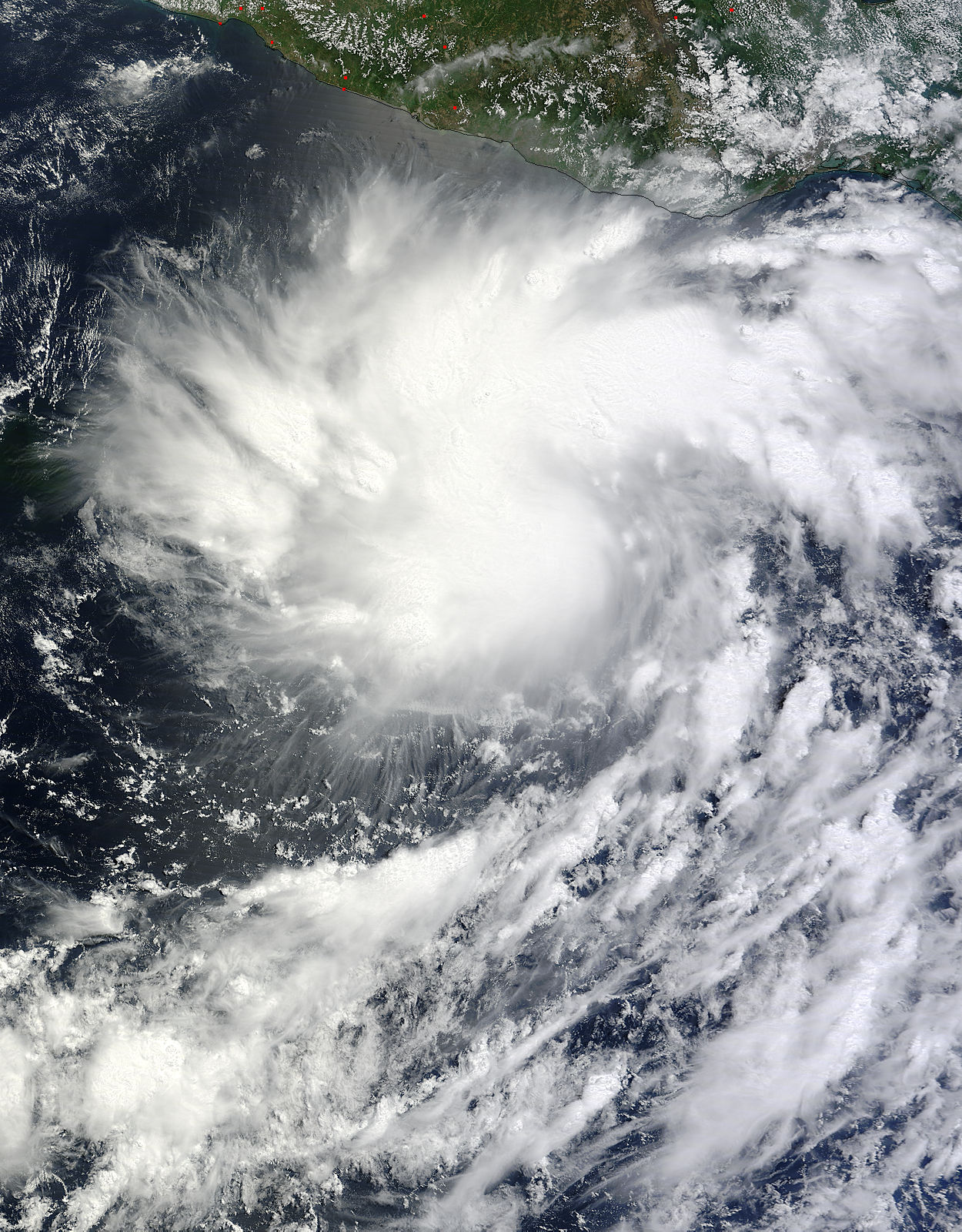
Hurricane Carlos has been crawling up the coast of southwestern Mexico, weakening and re-strengthening to hurricane force. NASA’s Terra satellite captured an image of the hurricane as it continued to cause coastal complications for the residents of western Mexico.
On June 15 at 17:45 UTC 1:45 p.m. EDT) the MODIS instrument aboard NASA’s Terra satellite captured an image of Hurricane Carlos over western Mexico. The MODIS image showed that Carlos is a compact storm with strong thunderstorms tightly circling the center. Carlos’ hurricane force winds extend outward up to 10 miles (20 km) from the center, and tropical storm force winds extend outward up to 60 miles (95 km). No eye was visible in the MODIS image as it was obscured by clouds, however the eye was seen using microwave data from satellite.
On June 16, a Hurricane Watch was in effect from Punta San Telmo to Playa Perula, Mexico and a Tropical Storm Warning was in effect from Punta San Telmo to Cabo Corrientes, Mexico
At 11 a.m. EDT (1500 UTC) Carlos was a minimal Category 1 hurricane on the Saffir-Simpson Wind Scale with maximum sustained winds near 75 mph (120 kph). The National Hurricane Center (NHC) expects little change in strength over the next day with weakening to begin on June 17.
Carlos’ center was located near latitude 17.5 North, longitude 104.3 West. That puts the storm’s center about 105 miles (165 km) south of Manzanillo, Mexico. Carlos was moving toward the west-northwest near 5 mph (7 kph). The NHC expects Carlos to turn to the northwest later on June 16 or on June 17. The estimated minimum central pressure is 989 millibars.
Hurricane-force winds, heavy rain, inland flooding and rough surf are the complications created from Carlos being so close to the coast. The NHC noted that Carlos is expected to produce heavy rains in the Mexican states of Guerrero, Michoacan, Colima, Jalisco, Nayarit, Durango, and Sinaloa with rainfall accumulations of 3 to 6 inches possible through Thursday morning, June 18. Isolated maximum amounts of 10 inches are also possible. As always with heavy rainfall in these area, the rains may produce life-threatening flash floods and mud slides, especially in areas of higher terrain.
The southwestern coast of Mexico continues to experience ocean swells and those are expected for the next few days. These swells could cause life-threatening surf and rip currents.
On the forecast track, Carlos should move parallel to and just offshore of the southwestern coast of Mexico over the next couple of days. For updates on Carlos’ strength, position and forecast, visit the NHC website: www.nhc.noaa.gov.
Rob Gutro
NASA’s Goddard Space Flight Center
June 15, 2015 – NASA Sees Tropical Storm Carlos Hugging Mexico’s West Coast
Tropical Storm Carlos approached the southwestern coast of Mexico over the past weekend of June 13-14, and satellite imagery shows the storm continues to hug the coast.
On Saturday, June 13, NASA’s RapidScat instrument showed Carlos’ sustained strongest winds were located southwest and north of its center. Those sustained winds were up to 35 mps (meters per second)/78.2 mph/126 kph. Carlos was a hurricane on June 13.
RapidScat is a scatterometer instrument that flies aboard the International Space Station and can measure surface winds over the ocean. Sustained winds around the rest of Carlos’ center were near 20 mps/44.4 mph/72 kph). Those tropical storm-force winds were affecting Mexico’s coast. The RapidScat image also showed that the low had good circulation.
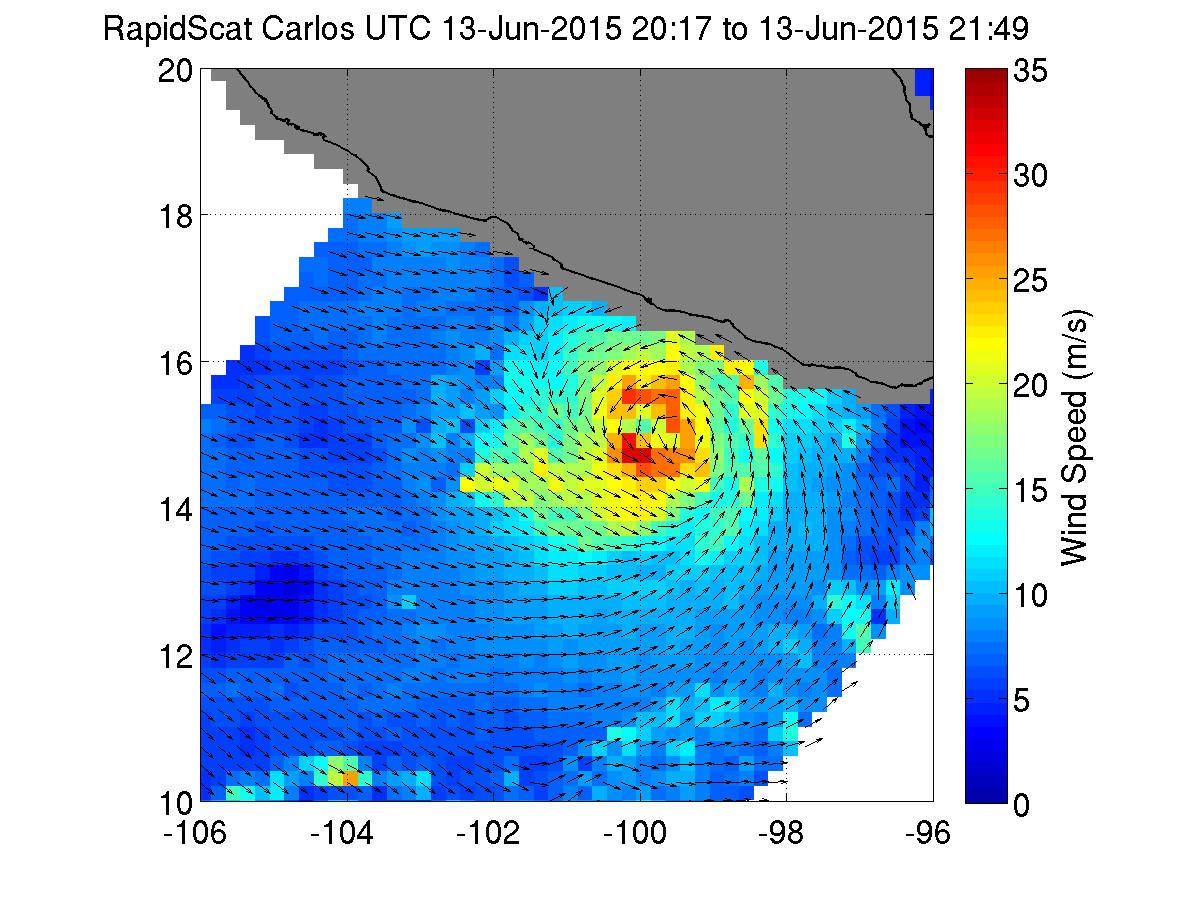
On Monday, June 15, NOAA’s GOES-West satellite captured an infrared image of Tropical Storm Carlos still hugging the southwestern Mexico coastline. The circulation appeared less structured than the previous two days on satellite imagery. There were still powerful thunderstorms surrounding the center of circulation, but the eye was not visible. Carlos is small cyclone. Tropical-storm-force winds only extend outward up to 45 miles (75 km) from the center.
The National Hurricane Center (NHC) posted a Hurricane Warning on June 15 from Punta San Telmo to Tecpan de Galeana, and a Hurricane Watch is in effect from west of Punta San Telmo to Playa Perula.
At 8 a.m. EDT (1200 UTC), the center of Tropical Storm Carlos was located near latitude 16.9 North, longitude 102.3 West. Carlos was moving toward the west-northwest near 6 mph (9 kph). The NHC said that this general motion is expected to continue through Tuesday (June 16), followed by a turn toward the northwest on Wednesday. Maximum sustained winds remain near 70 mph (110 kph) with higher gusts. The estimated minimum central pressure is 988 millibars (29.18 inches).
The NHC forecast calls for Carlos to move in a northwesterly direction over the next couple of days, hugging the coast of Mexico. Some strengthening is expected and Carlos is forecast to become a hurricane again by early Tuesday, June 16. Shortly thereafter, Carlos Is forecast to weaken back into a tropical storm and finally to a depression on June 17 all the while remaining just off the west coast of Mexico.
Rob Gutro
NASA’s Goddard Space Flight Center
June 12, 2015 – Tropical Storm Carlos Lingering off Mexico’s Southwestern Coast

NOAA’s GOES-West satellite is keeping an eye on slowly developing Tropical Storm Carlos as it lingers of the southwestern coast of Mexico. Carlos became the third tropical storm of the Eastern Pacific Ocean season on June 11 when Tropical Depression 03E intensified.
On June 12 at 15:00 UTC (11:00 a.m. EDT) NOAA’s GOES-West satellite captured a visible image of Tropical Storm Carlos that showed bands of thunderstorms being pushed south and west of the center as a result of northeasterly wind shear. Clouds and showers in the northern quadrant of the storm were lacking. The image was created by the NASA/NOAA GOES Project at NASA’s Goddard Space Flight Center, Greenbelt, Maryland.
At 11 a.m. EDT on June 12, the National Hurricane Center noted that a Tropical Storm Watch is in effect from Acapulco to Zihuatanejo. A Tropical Storm Watch means that tropical storm conditions are possible within the watch area, in this case within 36-48 hours. Tropical storm conditions are possible within the watch area by Saturday night, June 13. Locally heavy rains could spread over portions of the southern coast of Mexico, primarily in the states of Oaxaca and Guerrero, during the next couple of days.
On June 12 at 11 a.m. EDT, Tropical Storm Carlos’ maximum sustained winds were near 60 mph (95 kph). Carlos was centered near latitude 14.7 North, longitude 100.7 West. That puts the center of the storm about 160 miles (260 km) south-southwest of Acapulco Mexico, and about 215 miles (345 km) south-southeast of Zihuatanejo Mexico.
Carlos was stationary and is expected to move slowly northwest over the next couple of days. The estimated minimum central pressure is 997 millibars.
Ocean swells associated with Carlos are expected to increase near the coast of southern Mexico during the next few days. These swells could cause life-threatening surf and rip current conditions.
Forecaster Blake at the National Hurricane Center noted that “Carlos continues to be affected by northeasterly shear with the center on the north side of the convection. While an overnight microwave pass showed some increase in organization of the inner core, radar from Acapulco and the latest satellite images suggest that the system has become less organized since then.”
According to the National Hurricane Center (NHC), during the next day or two, the northeasterly shear is forecast to persist, so only a gradual intensification of Carlos is anticipated. Carlos is expected to become a hurricane over the weekend. For updated forecasts, visit NHC: www.nhc.noaa.gov.
Rob Gutro
NASA’s Goddard Space Flight Center
June 11, 2015 – NASA Saw Tropical Depression 3-E Coming Together
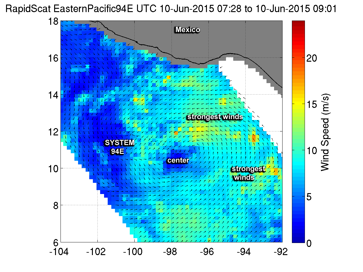
The third tropical depression of the active Eastern Pacific Ocean hurricane season formed and NASA’s RapidScat saw its winds coming together as it formed. NASA’s Terra satellite provided an image of the storm’s cloud extent showing bands of thunderstorms wrapping into its center.
RapidScat is a scatterometer instrument that flies aboard the International Space Station and can measure surface winds over the ocean. On June 10 from 07:28 to 09:01 UTC (3:28 to 5:01 a.m. EDT) RapidScat collected wind data on the strengthening tropical low pressure area known as System 94E. Strongest sustained winds during that time period were near 15 meters per second (mps)/33.5 mph/54 kph) in areas north and east of the center. Sustained winds around the rest of the low were weaker. The RapidScat image also showed that the low had good circulation.
As System 94E continued organizing NASA’s Terra satellite passed overhead at 17:25 UTC (1:25 p.m. EDT). The Moderate Resolution Imaging Spectroradiometer or MODIS instrument aboard captured infrared data on the tropical low pressure area, revealing a powerful, thick band of thunderstorms spiraling into the center from the northern quadrant of the storm. The storm continued to consolidate overnight and by June 11, Tropical Depression 03E was born.
At 5 a.m. EDT (0900 UTC) the National Hurricane Center (NHC) placed the center of Tropical Depression Three-E near latitude 13.1 North and longitude 100.2 West. That’s about 265 miles (425 km) south of Acapulco, Mexico. Maximum sustained winds remain near 35 mph (55 kph) with higher gusts. The estimated minimum central pressure is 1003 millibars (29.62 inches). The depression is moving toward the northwest near 8 mph (13 kph). A turn toward the north and a decrease in forward speed are expected to occur later today or tonight.
TD03E is close enough to the coast to cause ocean swells, bring rainfall and gusty winds. The NHC noted that locally heavy rains could spread over portions of the southern coast of Mexico, primarily in the states of Oaxaca and Guerrero, during the next couple of days. In addition, swells associated with the depression are expected to increase near the coast of southern Mexico during the next few days.
These swells could cause life-threatening surf and rip current conditions.
Strengthening is forecast during the next 48 hours, and the depression is expected to become a tropical storm later today.
Rob Gutro
NASA’s Goddard Space Flight Center