


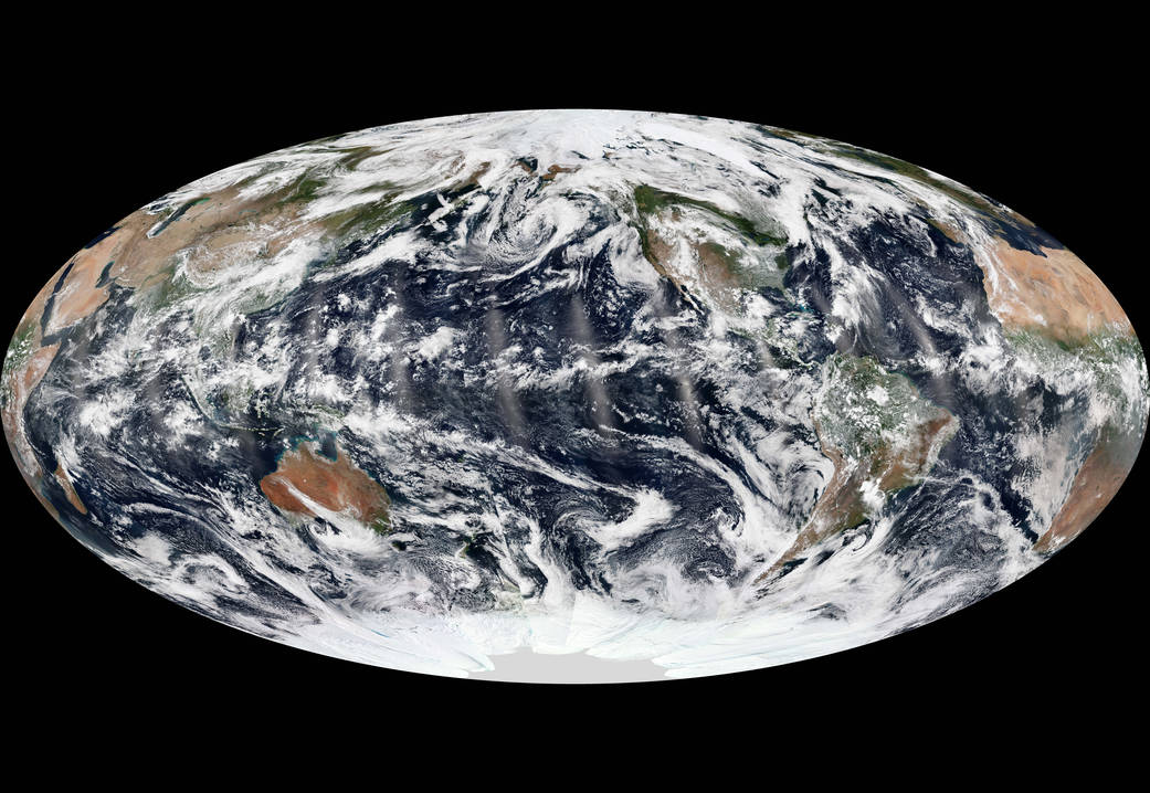
We live on a dynamic, restless planet. On any given day, there is usually a cyclone, tropical depression, or extra-tropical storm brewing somewhere on the Earth. But for a brief moment this week, the skies over all of the oceans were relatively calm.
The image above is a composite of fourteen polar satellite passes, or swaths, stitched together from September 8, 2013. The natural-color images were acquired by the Visible Infrared Imaging Radiometer Suite (VIIRS) on the Suomi National Polar-orbiting Partnership (Suomi NPP) satellite.
At the time of those near-midday passes, there were no hurricanes, cyclones, or tropical storms in the Atlantic, Pacific, or Indian Ocean basins—a relatively rare occurrence at the height of the hurricane/cyclone season in the northern hemisphere. There was plenty of cloud cover, of course, and smaller storm systems. In the eastern Pacific, remnants of tropical storm Lorena were breaking up near the Baja Peninsula. In the eastern Atlantic, the pieces of tropical depression #9 were starting to gather near the islands of Cape Verde; by the next day, tropical storm Humberto would form.
In its May and August 2013 outlooks, the National Hurricane Center forecasted a 70 percent chance of a “more active than normal” season, with 13 to 20 named storms and 7 to 11 hurricanes. A “normal” season typically produces 12 named storms, including 6 hurricanes. Through the second week of September (the midpoint of the Atlantic hurricane season), there have been nine named storms—keeping pace with predictions—but just one that reached hurricane strength.
The one hurricane, Humberto, was observed on September 11, 2013, by the Moderate Resolution Imaging Spectroradiometer (MODIS) on NASA’s Terra satellite. Humberto became a hurricane around 5 a.m. on September 11, just hours short of becoming the latest date for the first hurricane in a season. By September 13, Humberto had weakened to a tropical storm. Forecasts were calling for the northwest-moving storm to reach hurricane status again by September 19, when it will be in the middle of the Atlantic Ocean and well away from land.The slow start does not necessarily mean the hurricane season will be mild. “What happens in the early part of the season is generally not a good predictor of the second half of the season, which is when the majority of hurricanes and major hurricanes form,” said Gerry Bell, lead seasonal hurricane forecaster for the National Oceanic and Atmospheric Administration. “NOAA’s outlooks are for the season as a whole, and not for any particular month during the season.”
In the period from 1981 to 2010, the Atlantic basin has averaged six hurricanes per year, and 61 percent of all Atlantic named storms form from September through November. “The 2013 hurricane season was billed as a stud, but up through mid-September, it has been a dud,” said Bill Patzert, climatologist at NASA’s Jet Propulsion Laboratory. “Stay vigilant, though. Hurricanes could be late and active. Remember hurricane Sandy in late October last year.”
Image Credit: NASA Earth Observatory image by Jesse Allen, using VIIRS data from the Suomi National Polar-orbiting Partnership. Suomi NPP is the result of a partnership between NASA, the National Oceanic and Atmospheric Administration, and the Department of Defense. Caption Credit: Michael Carlowicz.Instrument: Suomi NPP – VIIRS