


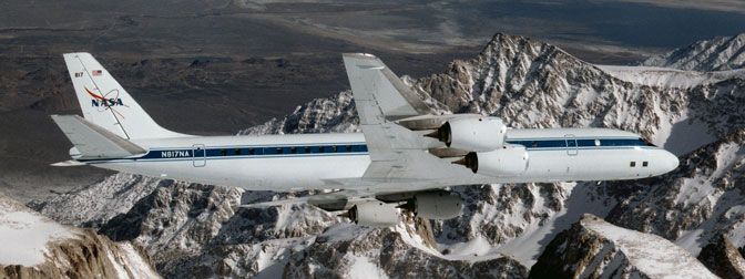
 NASA’s DC-8 airborne science laboratory soars over the Pinnacles near Mt. Whitney, Calif., during a checkout flight in the winter of 1998. The aircraft will validate several specialized instruments for the future Global Precipitation Measurement satellite during a six-week airborne campaign over Ontario, Canada in late January through February. (NASA / Jim Ross) › View Larger Image
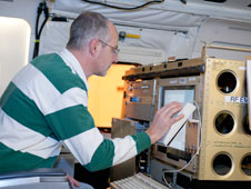 Steve Durden, Jet Propulsion Laboratory’s principal investigator for the Airborne Precipitation Radar or APR-2, checks out the instrument after installation on NASA’s DC-8 airborne science laboratory. APR-2 will provide radar data during for the GPM Cold-season Precipitation Experiment, or GCPEx, flown out of Bangor, Maine over a six- weeks period in late January through February 2012. (NASA / TomTschida) › View Larger Image PALMDALE, Calif. – Beginning Jan. 17, NASA will fly an airborne science laboratory above Canadian snowstorms to tackle a difficult challenge facing the upcoming Global Precipitation Measurement (GPM) satellite mission – measuring snowfall from space.
GPM is an international satellite mission that will set a new standard for precipitation measurements from space, providing next-generation observations of worldwide rain and snow every three hours. It is also the first mission designed to detect falling snow from space.
“Snow is notoriously hard to measure as it falls,” said Walter Petersen, the GPM ground validation scientist at NASA’s Wallops Flight Facility in Virginia. “Snowflakes contain varying amounts of air and water, and they flutter, wobble and drift as they leave the clouds.”
Knowing how “wet” a snowflake is allows scientists to measure overall water content. A wet, heavy snow can shut down a city, and melted snow is a crucial source of freshwater in many areas.
Working with Environment Canada, NASA’s GPM Cold-season Precipitation Experiment (GCPEx) will measure light rain and snow in Ontario from Jan. 17 to Feb. 29. The field campaign is designed to improve satellite estimates of falling snow and test ground validation capabilities in advance of the planned launch of the GPM Core satellite in 2014.
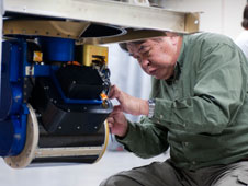 NASA Goddard engineer Zhaonan Zhang adjusts the Conical Scanning Millimeter-wave Imaging Radiometer, or CoSMIR, scan head prior to installation in NASA’s DC-8 flying science laboratory. The instrument is being used in the GCPEx airborne study of snowfall in Canada and the northeastern United States. (NASA / Tom Tschida) › View Larger Image NASA’s DC-8 airborne science laboratory will fly out of Bangor, Maine, carrying radar and a radiometer that will simulate the measurements to be taken from space by GPM. At an altitude of 33,000 feet (10 kilometers), the DC-8 will make multiple passes over an extensive ground network of snow gauges and sensors at Environment Canada’s Center for Atmospheric Research Experiments north of Toronto.
The GCPEx field experiment will help scientists match measurements of snow in the air and on the ground with the satellite’s measurements.
“We will be looking at the precipitation and the physics of precipitation, such as snowflake types, sizes, shapes, numbers and water content,” Petersen said. “These properties affect both how we interpret and improve our measurements.”
GPM’s Core satellite is being built at NASA’s Goddard Space Flight Center in Greenbelt, Md., with instruments provided by NASA and its mission partner, the Japanese Aerospace and Exploration Agency (JAXA). The spacecraft will orbit Earth at a 65-degree inclination, covering the world from the Antarctic Circle to the Arctic Circle.
GPM will carry a microwave radiometer and a dual-frequency precipitation radar that distinguishes a snowflake’s size and shape, which affects how much water it holds. Knowing these microphysical properties will lead to more accurate estimates of rain and snowfall, especially during winter and at high latitudes where snow is the dominant form of precipitation.
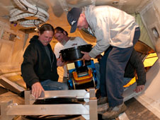 Dryden mechanic Larry Phillips (right), assisted by crew chief Pat Lloyd (left) and mechanic Donny Bailes (rear), mounts the Conical Scanning Millimeter-wave Imaging Radiometer, or CoSMIR, on a frame in the belly of NASA’s DC-8 airborne science laboratory. CoSMIR will simulate measurements to be taken from space by theGlobal Precipitation Measurement satellite when launched in 2014. (NASA / Tom Tschida) › View Larger Image The Ontario region is prone to both lake effect snow squalls and widespread snowstorms. If the opportunity exists, the DC-8 also will fly over blizzards along the northeastern United States. While the converted four-engine jetliner flies above the clouds, two other aircraft, one from the University of North Dakota and another from Canada, will fly through the clouds, measuring the microphysical properties of the raindrops and snowflakes inside.
Advanced ground radars will scan the entire air column from the clouds to the Earth’s surface.
“These multiple measurements of snowfall provide a complete picture, a complete model, of the snowfall process from top to bottom,” Petersen said.
NASA’s Dryden Flight Research Center in Edwards, Calif., manages the DC-8 flights for the GCPEx mission. The aircraft is based at the center’s aircraft operations facility in Palmdale, Calif. NASA’s Marshall Space Flight Center in Huntsville, Ala., is providing aircraft tracking and guidance through the Real Time Mission Monitor, as well as GCPEx real-time data and personnel support for the ground instruments in Canada.
For more information on the GCPEx ground validation, visit:
– end –
text-only version of this release
To receive status reports and news releases issued from the Dryden Newsroom electronically, send a blank e-mail message to dfrc-subscribe@newsletters.nasa.gov. To unsubscribe, send a blank e-mail message to dfrc-unsubscribe@newsletters.nasa.gov. The system will confirm your request via e-mail.
Steve Cole
Headquarters, Washington
202-358-0918
stephen.e.cole@nasa.gov
Beth Hagenauer
Dryden Flight Research Center
661-276-7960
beth.hagenauer@nasa.gov
Rani Gran
Goddard Space Flight Center, Greenbelt, Md.
301-286-2483
rani.c.gran@nasa.gov